Putún

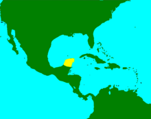
Putún is the name of a Mayan ethnic group on the periphery of Pre-Columbian Maya civilization. According to the encyclopedia Yucatán en el tiempo (Yucatán over Time) and other authors cited by the same encyclopedia, the people of Putún, called Putunes, are identified with and even assimilated into the Chontal Maya.[1] They were originally based in the delta of the Usumacinta and Grijalva Rivers, a region of waterways, lakes, and swamps in which aquatic transport dominated, as it did around the Laguna de Términos and through the numerous rivers that ended there. Although it is thought that over time the Putún inhabited a widespread area that consisted of important chiefdoms, like the Chakán Putún and the Chetumal.

The Putunes, or Chontal Maya, established founded two main populations: Potonchan (Putunchan), situated in the mouth of the Grijalva River in the current state of Tabasco, and Itzamkanac, near the Candelaria River, which ends at the Laguna de Términos in Campeche.
Area of influence
Groups of the Putún were, throughout their development, neighbors with groups of
As such, they extended their influence from villages in the Tabascan and Chiapan jungles to the coast of the Yucatán Peninsula. Precisely because they lived in an alluvial zone, they left few archaeological remnants that would speak to the Putunes' prehispanic importance, although when they integrated with other peninsular groups, a process that had already occurred by the Mesoamerican post-classical period, they became the inheritors of many of the archeological sites located in territories they inhabited.[1]
Historical data
The Probanza de Pablo Paxbolón, which was discovered and translated by France V. Scholes and Ralph L. Roys[3] attracted the interest of some Mayanists, particularly Eric S. Thompson, who Scholes and Roys worked with to reconstruct the pre-Columbian history of this ethnic group.[4]
After the classic Mayan collapse, which radically altered Mesoamerican geopolitics, the Putunes saw an era of expansion and, thanks to various migrations, reached such distant regions as the eastern coast of the Yucatán Peninsula, territory that belongs to Belize and Honduras today, where they established provinces or chiefdoms and confederated villages dedicated to trade and other economically productive activities.
During the Spanish conquest of the Yucatán, Putún territory was thought to have extend from the Copilco River to Comalcalco in the west (in what is now the state of Tabasco), through the deltas of the Usumacinta and Grijalva Rivers, passing through the Laguna de Términos and the Candelaria River Basin up to what is now the city of Champotón in Campeche.[1]
The toponomy of the region the Putún originally inhabited invites the assumption that there was intermingling, as typically occurs in border zones, between the mayas-putunes (the Chontal Maya) and the Aztecs. The paytonymics that, even today, are found in the region indicate this as well.[1]
Three provinces of Nahuatl origin, which were used to sustain constant wars, were found nestled in the territory dominated by the Chontal Maya:
- Ahualulco or Ayahualulco, a settlement on the western coast of the state of Tabasco, nearly within the current borders of the state of Veracruz.
- Huimango and Cimatán, in the municipality of Cunduacán, Tabasco.
- Xicalango, which was located between what are now the states of Tabasco and Campeche. This explains why many names among the Tabascan population are in Nahuatl.[5]
Connection with the Itza
For some scholars, there is an identity between the Putunes and the Itza people who arrived to the Yucatán during the early classical period. There is mention of an extant relationship between a Putún group settled in Chakán Putún that was thrown out and immigrated to Petén, in what is now Guatemala, and from there towards the coast of the Caribbean (Bacalar). Then they again headed towards the west through the north of the Yucatán Peninsula, founding cities like Chichén Itzá, Izamal, and Mayapán. All of this would have occurred between the second and fifth centuries CE. There is not, however, historical certainty surrounding these migrations and the dates which they occurred, nor for the hypothesis that establishes that those which were identified as members of the Itza had been Putunes in reality.[1]
See also
- Chontal Maya
- Mayan chiefdoms of the Yucatán Peninsula
- History of the Yucatán
- Discovery of the Yucatán
- Spanish conquest of the Yucatán
- Itza people
- Kowoj
- Kuchkabal
References
- ^ a b c d e "Yucatán en el tiempo : enciclopedia alfabética | WorldCat.org". search.worldcat.org. p. 238-39. Retrieved 2024-03-25.
- ^ Roys, Ralph (1957-01-01). "The Political Geography of the Yucatan Maya". KIP Monographs.
- ISBN 978-970-701-159-5.
- ISSN 2448-6221.
- ^ Gil y Sáenz, Manuel (1872). Compendio histórico, geográfico y estadístico del Estado de Tabasco [Historical, geographical, and statistical compendium of the State of Tabasco] (in Spanish). pp. 76, 77.
