Putney Bridge
Putney Bridge | |
|---|---|
 | |
| Coordinates | 51°28′00″N 0°12′48″W / 51.466563°N 0.21339°W |
| Carries | A219 road |
| Crosses | River Thames |
| Locale | London, England |
| Maintained by | Wandsworth London Borough Council |
| Preceded by | Hammersmith Bridge |
| Followed by | Fulham Railway Bridge |
| Characteristics | |
| Design | Arch bridge |
| Total length | 700 feet (210 m) |
| Width | 75 feet (23 m) |
| History | |
| Opened |
|
| Statistics | |
Listed Building – Grade II | |
| Official name | Putney Bridge |
| Designated | 7 April 1983 |
| Reference no. | 1079799 |
| Location | |
 | |
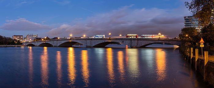
Putney Bridge is a Grade II listed bridge over the River Thames in west London, linking Putney on the south side with Fulham to the north.[1] Before the first bridge was built in 1729, a ferry had shuttled between the two banks.
The current format is three lanes southbound (including one bus lane) and one lane (plus cycle lane/bus stop) northbound.
Position
The north side of the bridge is 120m
The bridge has medieval parish churches beside its abutments: St Mary's Church, Putney is built on the south and All Saints Church, Fulham on the north bank. This close proximity of two churches by a major river is rare, another example being at Goring-on-Thames and Streatley, villages hemmed in by the Chiltern Hills (the Goring Gap).
History
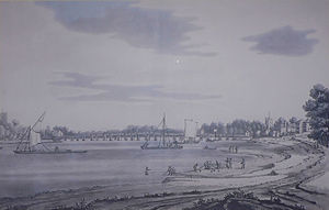
First bridges

The first bridge of any kind between the two parishes of Fulham and Putney was built during the Civil War: after the Battle of Brentford in 1642, the Parliamentary forces built a bridge of boats between Fulham and Putney. According to an account from the period:
The Lord-Generall hath caused a bridge to be built upon barges and lighters over the Thames, between Fulham and Putney, to convey his army and artillery over into Surry, to follow the King's forces; and he hath ordered that forts shall be erected at each end thereof to guard it; but for the present the seamen, with long boats and shallops, full of ordnance and musketeers, lie there upon the river to secure it.[2]
In 1720 Sir
| Fulham and Putney Bridge Act 1725 | |
|---|---|
| Act of Parliament | |
 12 Geo. 1. c. 36 | |
| Dates | |
| Royal assent | 24 May 1726 |
| Fulham Bridge Act 1727 | |
|---|---|
| Act of Parliament | |
 1 Geo. 2. St. 2 . c. 18 |
The legal framework for construction of a bridge was approved by an
In October 1795, Mary Wollstonecraft, philosopher and early women's equality advocate, allegedly planned to commit suicide by jumping from the bridge, because she had returned from a trip to Sweden to discover that her lover was involved with an actress from London.[5]
The bridge was the starting point for The Boat Race from 1845 until the new iron aqueduct was built just upstream in 1856, after which this became the starting point. The competitors are currently 32 men of the universities of Oxford and Cambridge with two crews of first and second eights. Women's eights competed in an equivalent race for the first time in 2015, having since 1927 competed a shorter varsity race in Henley also in the early spring.[6]
The bridge was badly damaged by the collision of a river barge in 1870. Although part of the bridge was subsequently replaced, the entire bridge was then demolished to make way for construction of the current bridge. The iron aqueduct was also demolished as the new bridge carried the water in pipes beneath the road surface.
Current bridge

The Metropolitan Board of Works purchased the bridge in 1879, discontinued the tolls in 1880, and set about its replacement.
In 1886 construction of the stone bridge that stands today, on a new alignment, was completed. A new road – Putney Bridge Approach – was laid to connect the northern end of the new bridge with
The stone marking the downstream end of the Championship Course is used for all boat races through Putney in Olympic-class rowing boats. These include the Wingfield Sculls and the UK's main Head of the River Races, just west of the bridge, rather than at the bridge itself, under which the centre of its middle arch would provide an advantage if starting underneath it, as all races are competed with the tide.
In 2007, the bridge suffered considerable damage by a developer who cut several holes into the Cornish granite of the southern approach of the bridge.[8][9]
On 14 July 2014, Putney Bridge closed for three months, except to pedestrians and dismounted cyclists, to undergo "essential repairs" by
On 5 May 2017 an unidentified jogger on the bridge pushed over a woman, where an approaching bus narrowly avoided hitting her.

See also
- Crossings of the River Thames
- Putney Bridge tube station
- List of bridges in London
References
- ^ Historic England (7 April 1983). "Putney Bridge (1079799)". National Heritage List for England. Retrieved 5 September 2020.
- ^ Faulkner, Thomas (1813). An Historical and Topographical Account of Fulham: Including the Hamlet of Hammersmith. T. Egerton.
- ^ "Putney Bridge on Londonhistorians.org".
- ^ a b c "Putney Bridge: Where Thames Smooth Waters Glide". thames.me.uk. Retrieved 7 October 2021.
- ISBN 978-0801411649.
- ^ "Women's Boat Race set for men's course from 2015". BBC. 7 February 2012. Retrieved 10 April 2012.
- ^ UK Retail Price Index inflation figures are based on data from Clark, Gregory (2017). "The Annual RPI and Average Earnings for Britain, 1209 to Present (New Series)". MeasuringWorth. Retrieved 11 June 2022.
- ^ "A bridge too far". Evening Standard. 25 March 2008. Retrieved 31 May 2014.
- ^ "Injunction stops Putney Bridge drilling". Wandsworth Guardian. 13 December 2007. Retrieved 31 May 2014.
- ^ "Getting around while Putney Bridge is closed". Metro: 50. 15 July 2014.
- ^ Edmonds, Lizzie (26 September 2014). "Putney Bridge reopens to road traffic two weeks ahead of schedule". Evening Standard. Retrieved 22 June 2023.
- ^ "Putney Bridge jogger assault investigation case closed". BBC News. 28 June 2018. Retrieved 7 October 2021.
- ^ "The unsolved mystery of the Putney Pusher". Wired. 14 October 2021. Retrieved 22 October 2021.
- Raidió Teilifís Éireann. 11 February 2021. Retrieved 7 October 2021.

