
Pweto Territory
Pweto Territory | |
|---|---|
UTC+2 (CAT ) |
Pweto Territory is a territory in the Haut-Katanga Province of the Democratic Republic of the Congo (DRC). The headquarters are in the town of Pweto.
Geography
Pweto is part of Haut-Katanga Province. It lies to the west and north of Lake Mweru on the border with Zambia. The Luvua River, a headstream of the Congo River, leaves the lake just west of the town of Pwetu to flow north its confluence with the Lualaba River opposite the town of Ankoro.[2] Other rivers flowing through the territory include the Lubule River, the Lumekele River and the Kilulishi River. The territory is subdivided into the following
Economy
The territory is agriculturally productive and the lake is rich in fish. There is no formal industry apart from the
Security issues
Pweto Territory saw several combats during the Congo wars. With the cease fire, the front line between the
The forests of Pweto territory were once home to thousands of pygmies, locally called
A 2007 report said there was no longer any significant presence of
Gallery
-
 Children outside a house on the road from Pweto to Dubie
 -
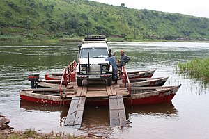 Car being ferried across the Luvua River near Pweto


References
- ^ a b "Cellule d'Analyses des Indicateurs de Développement". caid.cd (in French). Archived from the original on 2021-04-11. Retrieved 2023-03-25.
- ^ "Carte des Districts et Territoires du KATANGA" (PDF). Reliefweb. April 2002. Retrieved 2010-10-30.
- ^ X. Blaes (October 2008). "Découpage administratif de la République Démocratique du Congo" (PDF). PNUD-SIG. Archived from the original (PDF) on 2010-04-01. Retrieved 2011-11-02.
- ^ a b c Steven Spittaels, Nick Meynen (2007). "Mapping interests in conflict areas: Katanga" (PDF). IPIS. Retrieved 2011-10-30.
- ^ "Rebuilding livelihoods and social cohesion in Pweto, Katanga". GTZ. Retrieved 2011-10-30.
- ^ Héritier Maila. "Democratic Republic of Congo: Persecuted pygmies driven from forest home". Africa Files. Retrieved 2011-10-30.