
Qal'at al-Bahrain
قلعة البحرين Forte de Barém | |
 | |
 Shown within Bahrain | |
| Location | Capital Governorate, Bahrain |
|---|---|
| Coordinates | 26°14′01″N 50°31′14″E / 26.23361°N 50.52056°E |
| Type | Settlement |
| History | |
| Founded | 2300 BC |
| Abandoned | 16th century AD |
| Site notes | |
| Condition | In ruins |
Arab States | |
The Qal'at al-Bahrain (
About
The fort and the tell Qal'at al-Bahrain is built on, are located on the Bahrain island, on the northern seashore. On a clear day it is also seen from Saar. It stands like a "sentinel" near Manama, the capital of Bahrain; it is 6 km (4 mi) away from Manama on the fertile north coast.[3][4] The tell is the largest in the Persian Gulf region and was built close to the port and by reclamation of seashore land.
History and explorations
The archaeological findings, which are unearthed in the fort,reveal much about the history of the country. The area is thought to have been occupied for about 5000 years and contains a valuable insight into the Copper and Bronze Ages of Bahrain.[5] The first Bahrain Fort was built around three thousand years ago, on the northeastern peak of Bahrain Island. The present fort dates from the sixth century AD.[6] The capital of the Dilmun civilization, Dilmun was, according to the Epic of Gilgamesh, the "land of immortality", the ancestral place of Sumerians and a meeting point of gods.[5]

The site, 17.5 hectares in area, has been termed as Bahrain's "most important site in antiquity". The first excavation at the site was carried out by a Danish archaeological expedition led by

Description
Qal`at al-Bahrain is a typical
The site contains many areas and walls, including Saar necropolis, Al-Hajjar necropolis, Kassite Palace, Madimat Hermand necropolis, Madimat Isa necropolis, Al-Maqsha Necropolis, Palace of Uperi, Shakhura necropolis, and the Northern city wall.[16] The ruins of the Copper Age consists of two sections of the fortification wall surrounding streets and houses, and a colossal building on the edge of the moat of the Portuguese fort in the centre.[5] Barbar pottery has been unearthed around the walls of the central building, dating back to the same age as the Barbar Temples, although some of the other pottery and range of unearthed artefacts indicated that they predated the temples, dating back to 3000 BC or later.[5] Relics of copper and ivory provide an insight into ancient trade links.[5] Many vessels have been unearthed on the site, and Danish excavations of the Palace of Uperi area revealed "snake bowls", sarcophagi, seals and a mirror, among other things.[16]
Layout
The excavations of the tel have revealed a small settlement, the only one of that period in eastern Arabia, on its northern side. It has been inferred that the village was settled by people who developed agriculture near the oasis, planted palm trees, tended cattle, sheep and goats and also ventured into fishing in the Arabian Sea. The small houses they built were made of rough stone with clay or mortar as binding material. The plastered floors in the houses were said to have been spacious. Excavations also hinted that the village had streets which separated the housing complexes.[17]
The fortifications seen in the excavated tel area were found around the township and were erected in cardinal directions. The fort walls are seen now only in the northern, western and southern slopes of the tel, and the eastern side is yet to be excavated. The fortifications covered an area of 15 ha (37 acres), and the walls were built with varying thickness by using
There was a palace in the centre of the tel at a commanding location consisting of several warehouses which were inferred as indicative of economic activity during the Dilmun period. Proceeding from here towards the north, along the street leads, to a large gate that probably was the entry to the palace grounds. The modest houses built in the same size and type of construction were laid along a network of roads.[17]
The place prospered till 1800 BC after when it was deserted. Eventually the town became covered with drift sand from the sea.[17]
.jpg)
Relics
Metal artifacts found in the tell were limited to copper pieces, fishing tools and a socketed spearhead; a workshop of 525 m (1,722 ft) size was also identified where copper casting two piece moulds and wax moulds were found. Small and large crucibles used for melting of metal were recovered in substantial quantities indicative of large scale manufacture by professional artisans. The copper ware was then traded in surrounding countries such as Oman and Mesopotamia. Dilmun stamp seals were also recovered from the excavations.[17]
Pots and vessels were also recovered. Pots were used for cooking, while the large vessels for food import from Oman and Mesopotamia. Artifacts found there indicates the location. These include a
Gallery
-
 Overview of the Bahrain Fort
 -
 Staircase inside the fort
 -
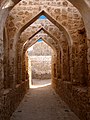 Archways present in the fort
 -
 The exterior view of the fort
 -
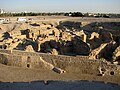 Archaeological excavations at the site
 -
 Dilmunite ruins at the fort
 -
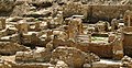 Ruins at the fort


See also
- List of archaeological sites in Bahrain
- Cities of the ancient Near East
- Tell Dehaila
References
- ^ a b c "Qal'at al-Bahrain – Ancient Harbour and Capital of Dilmun". United Nations Educational, Scientific and Cultural Organization. Retrieved 28 April 2011.
- ^ a b "Qal'at al-Bahrain (Bahrain) no 1192" (PDF). United Nations Educational, Scientific and Cultural Organization. Retrieved 28 April 2011.
- ISBN 978-99901-37-04-0. Retrieved 30 April 2011.
- ISBN 978-1-902339-73-3. Retrieved 30 April 2011.
- ^ ISBN 978-0-9505211-7-6. Retrieved 5 May 2011.
- ISBN 978-0-7614-7571-2. Retrieved 5 May 2011.
- ^ Geoffrey Bibby, Looking for Dilmun, Knopf, New York, 1969 ISBN 9780394434001
- ^ Lombard, Pierre. "The French Archaeological Mission at Qal'at al-Bahrain, 1989-1994: Some results on Late Dilmun and later periods." Dilmun 16 (1996): 26-42
- ^ André-Salvini, B., and P. Lombard. “La Découverte Épigraphique de 1995 à Qal’at al-Bahrein: Un Jalon Pour La Chronologie de La Phase Dilmoun Moyen Dans Le Golfe Arabe.” Proceedings of the Seminar for Arabian Studies, vol. 27, 1997, pp. 165–70
- ISBN 9782865380770. Retrieved 5 May 2011.
- ^ Potts, D. T. “Elamites and Kassites in the Persian Gulf.” Journal of Near Eastern Studies, vol. 65, no. 2, 2006, pp. 111–19
- ^ Højlund, Flemming. Qala'at al-Bahrain/2 The central monumental buildings. Aarhus Univ. Press, 1997
- ^ Højlund, Flemming. "Qala'at al-Bahrain/volume 3 The Western and Southern city walls and other excavations." Qala'at al-Bahrain (2019).
- ^ Højlund, Flemming, and H. Hellmuth Andersen. "Qala'at Al-Bahrain./ 1 The Northern city wall and the Islamic fortress" Aarhus Aarhus Univ. Press 1994
- ISBN 978-0-7103-0112-3. Retrieved 5 May 2011.
- ^ ISBN 978-1-86064-742-0. Retrieved 5 May 2011.
- ^ ISBN 978-0-9538666-0-1. Retrieved 7 May 2011.
More Information
- [1] Lombard, Pierre. "Qal’at al-Bahrain, Ancient Capital and Harbour of Dilmun. The Site Museum." (2016).
- Lombard, P. 1986. Iron Age Dilmun. A reconsideration of City IV at Qala’t al Bahrain. In: A.M al-Khalifa and M. Rice (Eds.), Bahrain through the Ages. London. pp. 225–232
- Kervran, Monik; Hiebert, Fredrik Talmage; Rougeulle, Axelle (2005). Qalʻat al-Bahrain: a trading and military outpost 3rd millennium B.C. – 17th century A.D. ISBN 978-2-503-99107-8.
| International | |
|---|---|
| Geographic | |