
Qeshm Island
Hormozgān | |
|---|---|
| County | Qeshm |
| Bakhsh | Central |
| Largest settlement | Qeshm (pop. 40,678) |
| Demographics | |
| Population | 148,993 (2016) |
| Pop. density | 67.07/km2 (173.71/sq mi) |
Qeshm (
Geography

Qeshm Island is located a few kilometers off the southern Iran shoreline (
The average temperature on the island is approximately 27 °C (81 °F). The warmest months are June through August, and the coldest from October to January. The average
The island, comprising 59 towns and villages, had a population of 117,774 at the time of the 2011 Census. The local population is engaged in fishing, dhow construction, trade and services. An additional 30,000 are administrative or industrial workers or students.
Plans have also been made to build a bridge to connect Qeshm with mainland Iran.[1][2]
Qeshm Island has multiple attractions to attract more domestic and foreign tourists.[3]
Namakdan Salt Cave
At 6.58km long, Namakdan Salt Cave is the longest known
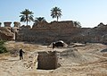
History
.jpg)
The earliest evidence of human presence at Qeshm dates back to the
Explorer William Baffin was mortally wounded on Qeshm in 1622 during a battle against Portuguese forces who occupied the fort, known to the English as "Forte de Queixome".
Qeshm is also a supposed site of the Garden of Eden according to Cassell's Bible.[8]
Iran Air Flight 655
On 3 July 1988, a civilian
The wreckage crashed 2.5 kilometers off Qeshm's southern coast.Economy
-
 Naaz Islands, sea bed at low tide
 -
 Sea bed at Naaz Islands
 -
 Oysters in the holes of the Sea bed, Naaz Islands
 -
 Dolphins in the strait between Qeshm and Hengam Island.
 -
 Qeshm
Qeshm

.jpg)
.jpg)
.jpg)
.jpg)
In the 1st ten-year plan, in note 19, the law provided for the creation of
-
 Portuguese castle, Qeshm
 -
 Chahkouh Valley at Qeshm Island
 -
 Stars Valley at Qeshm Island
 -
 A tourist running on the island beach
 -

-
 Portuguese castle exterior
 -
 Portuguese castle interior
 -
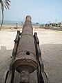 One of the cannons of Qeshm Portuguese castle
 -

-
 Qeshm International Airport - 2019
 -
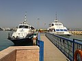 Shahid Zakeri Wharf


_003.jpg)
.jpg)
.jpg)


Qeshm Island underground military facility
On 20 January 2012, OSGEOINT[clarification needed] established the completion of an underground military facility at Qeshm island which accordingly could house Iran's Ghadir-Nahang class submarines.[11]
Economy, culture, and education
- Qeshm Institute of Higher Education
- Islamic Azad University of Medical Science Qeshm International Branch
Visas
Holders of normal passports travelling as tourists can enter Qeshm without a visa with maximum stay of 30 days (extendable), as of December 2017.[12][13]
Admission is refused to holders of passports or travel documents containing an Israeli visa or stamp or any data showing that visitor has been to Israel or indication of any connection with the state of Israel during the last 12 months.[14]
See also
- 2005 Qeshm earthquake
- Ardashir-Khwarrah
- Bandar Lengeh
- Hormozgan
- Qeshm Air
- Qeshm International Airport
References
- ^ "Austrians to Construct Persian Gulf Bridge to Connect Qeshm Island to the Main Island". payvand.com. Retrieved 2016-10-05.
- ^ "Qeshm – Dictionary definition of Qeshm | Encyclopedia.com: FREE online dictionary". www.encyclopedia.com. Retrieved 2016-10-05.
- ^ "Qeshm Island and its tourist attractions". IFPNews.com. Retrieved 2016-10-05.
- ^ "Namakdan Salt Cave". IUGS International Commission on Geoheritage. IUGS. Retrieved 2 November 2022.
- ^ "Namakadan Salt Cave, Iran" (PDF). IUGS International Commission on Geoheritage. IUGS. Retrieved 2 November 2022.
- ^ "Iranian Archaeologists Uncover Paleolithic Stone Tools on Qeshm Island – Tasnim News Agency". Tasnim News Agency. Retrieved 2018-07-09.
- S2CID 194982986.
- ^ LTD, Kaspid. "Qeshm Island". www.arian-tour.com. Archived from the original on 2017-09-02. Retrieved 2016-08-26.
- ^ "Iran Air flight 655 | Background, Events, Investigation, & Facts". Encyclopedia Britannica.
- ^ Qeshm Island Archived July 4, 2008, at the Wayback Machine, Qeshm Energy International
- ^ Iran: Underground Naval Base at Qeshm Complete. Published by: OSGEOINT. OSGEOINT
- ^ "مزایای ثبت شرکت در مناطق آزاد". companyregister.ir.
- ^ "No visa required for Iran". June 30, 2015.
- ^ Visa information on the site of IRI Embassy in Moscow
Further reading
- Speak the Wind (Mack, 2021; photographs by Hoda Afshar; essay by Michael Taussig[1]) This work documents the landscapes and people of the islands of Hormuz, Qeshm, and Hengam, in the Persian Gulf off the south coast of Iran.[2][3] Afshar got to know some of the people there, travelling there frequently over the years, and they told her about the history of the place. She said that "their narrations led the project", and she explores "the idea of being possessed by history, and in this context, the history of slavery and cruelty”.[4]
External links
- About Qeshm Island (Qeshm Island Global Geopark)
| Capital |
| ||||||||||||||||||||||||||||||||
|---|---|---|---|---|---|---|---|---|---|---|---|---|---|---|---|---|---|---|---|---|---|---|---|---|---|---|---|---|---|---|---|---|---|
| Districts |
| ||||||||||||||||||||||||||||||||
|  | |||||||||||||||||||||||||||||||||||||||||||||||||||||||||||||||||||||||
|
| ||||||||||||||||||||||||||||||||||||||||||||||||||||||||||||||||||||||||
| ||||||||||||||||||||||||||||||||||||||||||||||||||||||||||||||||||||||||
| ||||||||||||||||||||||||||||||||||||||||||||||||||||||||||||||||||||||||
| ||||||||||||||||||||||||||||||||||||||||||||||||||||||||||||||||||||||||
| ||||||||||||||||||||||||||||||||||||||||||||||||||||||||||||||||||||||||
| International | |
|---|---|
| National | |
| Geographic | |
- ISBN 978-1-913620-18-9.
- ^ Boetker-Smith, Daniel; Afshar, Hoda. "Speak the Wind - Book review". LensCulture. Photographs by Hoda Afshar. Retrieved 14 February 2022.
- ^ Colberg, Jörg (16 August 2021). "Speak The Wind". Conscientious Photography Magazine. Retrieved 14 February 2022.
- ^ Grieve, Michael (19 July 2021). "Hoda Afshar captures the wind and rituals of the islands in the Strait of Hormuz". 1854 Photography. Retrieved 14 February 2022.