
Qualibou
| Qualibou | |
|---|---|
 View from Gros Piton over the Qualibou caldera | |
| Highest point | |
| Elevation | 777 m (2,549 ft)[1] |
| Coordinates | 13°50′17″N 61°02′46″W / 13.838°N 61.046°W |
| Geography | |
 Qualibou | |
| Geology | |
| Age of rock | 32,000–39,000 years |
| Mountain type | Caldera[2] |
| Last eruption | 1766 |
Qualibou, also known as the Soufrière Volcanic Center, is a 3.5 × 5 km-wide caldera on the island of Saint Lucia that formed between 32,000 and 39,000 years ago. This eruption also formed the Choiseul Tuff which covers the southeastern portion of the island.
The Pitons are two large lava domes that formed 200 to 300,000 years ago,[citation needed] before the formation of the caldera; ever since then, other domes have filled the caldera floor. There was a phreatic eruption in 1766 that deposited volcanic ash
over a wide area.
Sulphur Springs is an active geothermal area located roughly in the center of the caldera.
In 1990, 1999 and 2000 there were shallow volcanic earthquakes located 6 km ESE of the caldera.[3]
Gallery
-

-
 Petit Piton
 -
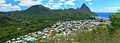 Soufrière and the Pitons


References
- ^ This elevation is for Gros Piton, however Morne Gimie on the edge of the caldera has an elevation of 950 m.
- ^ Global Volcanism Program, 1990. Report on Qualibou (Saint Lucia) (McClelland, L., ed.). Bulletin of the Global Volcanism Network, 15:5. Smithsonian Institution. DOI: 10.5479/si.GVP.BGVN199005-360140
- ^ The University of the West Indies Seismic Research Centre (www.uwiseismic.com). "St Lucia".
External links
- "Qualibou". Global Volcanism Program. Smithsonian Institution. Retrieved 2021-06-27.
| History |  | ||||
|---|---|---|---|---|---|
| Geography | |||||
| Politics | |||||
| Economy | |||||
| Society |
| ||||
| Authority control databases: Geographic |
|---|
This Saint Lucia location article is a stub. You can help Wikipedia by expanding it. |