
Quiapo, Manila
Quiapo | ||
|---|---|---|
District of Zip codes 1001 | ||
| Area codes | 02 | |
Quiapo ([ˈkjapɔʔ]) is a district of the city of Manila, in the National Capital Region of the Philippines. Referred to as the “Old Downtown of Manila", the district’s most famous landmark is Quiapo Church, a minor basilica enshrining the Black Nazarene image processed every January by millions of devotees. Quiapo is also known as a place for bargain hunting.
Geographically located at the very center of the City of Manila, it is bounded by the Pasig River and Estero de San Miguel to the south, San Miguel district to the east, the districts of Sampaloc and Santa Cruz and Recto Avenue to the north, and the Santa Cruz district and Rizal Avenue to the west.
Etymology
Quiapo's name is derived from the abundance of water cabbage (
History
Pre-1800 maps of Manila show that Quiapo, historically a poor fishing village, was originally a cluster of islands with marshlands and shallow waters. In 1578,
Franciscan prelate Pedro Bautista petitioned to make Quiapo a separate town. The petition was finally granted by Governor-General Santiago de Vera on August 29, 1586.[5] In 1622, Augustinians arrived and founded a chapel in honor of St. Sebastian at the present-day site of the San Sebastian Basilica. By 1850, then a small agricultural village, population of Quiapo grew as a result of a developing economy in the wake of the Manila galleon trade's termination and the subsequent opening of the country to world trade in 1830. Newly rich mestizos started settling in Quiapo, as well as many rich Europeans, including Spanish army officers.[4]
Quiapo had become a wealthy suburb. Since the American insular government and commonwealth periods through to the late 1970s, it shared its status as the center of the activities of Manila's social elites as well as trade, fashion, art and higher learning with its surrounding vicinity (Avenida Rizal, Santa Cruz, Escolta and the University Belt). However, with the construction of the Manila Light Rail Transit System's LRT-1 spanning over Rizal Avenue, the occlusion of light, the trapping of smog and vehicle emissions left the streets beneath dark, gloomy and with an increase in crime and transients. Consequently, many long-time establishments vacated the area. Following the People Power Revolution in 1986, the vibrancy of Quiapo further diminished, with the void filled by makeshift markets to accommodate visitors to the Quiapo Church.
The Quiapo was plot setting for the 1986 film Batang Quiapo and its television adaptation and the episode Paa of the 2010 horror film Cinco.
Community
.jpg)
The Quiapo district is also home to a sizable
Stores offering herbal products, and a large population of self-described fortune tellers, surround the Quiapo church. Thievery and sales of illegally copied media[7][8] are prevalent in the district.
In recent years, the local government of Manila, spearheaded by then-Mayor Lito Atienza, launched the Buhayin ang Maynila ("Revitalize Manila") project which greatly rehabilitated Quiapo and its vicinities, most especially Plaza Miranda, Quinta Market, the Arsenio Lacson Underpass and the University Belt. Parts of Rizal Avenue, starting from Carriedo Street to Recto Avenue, were converted into pedestrian shopping arcades.
Barangays

Quiapo contains 16
| Zone/Barangay | Land area (km2) | Population (2020 census) |
|---|---|---|
| Zone 30 | ||
| Barangay 306 | 0.1013 km2 | 1,248 |
| Barangay 307 | 0.07246 km2 | 1,378 |
| Barangay 308 | 0.04002 km2 | 1,033 |
| Barangay 309 | 0.06061 km2 | 1,151 |
| Zone 39 | ||
| Barangay 383 | 0.02049 km2 | 2,267 |
| Barangay 384 | 0.058606 km2 | 3,511 |
| Barangay 385 | 0.07433 km2 | 3,406 |
| Barangay 386 | 0.07397 km2 | 1,213 |
| Barangay 387 | 0.03622 km2 | 2,654 |
| Barangay 388 | 0.02522 km2 | 1,260 |
| Zone 40 | ||
| Barangay 389 | 0.04103 km2 | 1,174 |
| Barangay 390 | 0.06551 km2 | 792 |
| Barangay 391 | 0.06377 km2 | 2,558 |
| Barangay 392 | 0.02962 km2 | 695 |
| Barangay 393 | 0.09322 km2 | 4,073 |
| Barangay 394 | 0.02663 km2 | 1,433 |
Gallery
-

-

-

-
 Quinta Market & Fish Port
 -
 Welcome Arch of Quiapo Muslim Town
 -
 Eid'l Fitrin 2019
 -
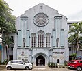 The United Church of Manila

.jpg)
.jpg)
.jpg)

_(18).jpg)

Notable people
See also
References
- ^ "2020 Census of Population and Housing Results" (PDF). Philippine Statistics Authority. August 16, 2021. Retrieved April 7, 2023.
- ^ Merrill, Elmer Drew (1903). A Dictionary of the Plant Names of the Philippine Islands. Manila: Bureau of Public Print. p. 8.
- ^ McLennan, Marshall S. (1980). The Central Luzon Plain: Land and Society on the Inland Frontier. Alemar-Phoenix Publishing House. p. 166.
- ^ ISBN 9789719367307.
- ^ "A Question of Quiapo Faith". World Mission Magazine. January 2021. Retrieved April 10, 2023.
- ^ Mortel, Paul R. (June 23, 2007). "Inquirer Opinion / Letters to the Editor: Rename Plaza Miranda after Ramon Magsaysay Sr". Inquirer.net. Retrieved October 29, 2007.
- ^ Aguilon, Erwin (November 11, 2011). "Anti-piracy agents raid Quiapo haven, recover 5 replicating machines". Philippine Daily Inquirer. Retrieved January 8, 2014.
- ^ "Another Quiapo raid yields P24M in pirated discs". GMA News Online. June 5, 2013. Retrieved January 8, 2014.
External links
 Media related to Quiapo, Manila at Wikimedia Commons
| Topics |  | |
|---|---|---|
| Government | ||
| Districts | ||
| Mixed-use developments | ||
| Beaches | ||
| Legislative districts | ||