
Río de la Plata (Puerto Rico)
| La Plata River | |
|---|---|
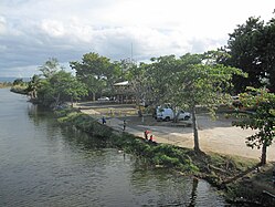
 La Plata River in 2007 | |
| Native name | Río de la Plata (Spanish) |
| Location | |
| Commonwealth | Puerto Rico |
| Municipality | Guayama, Cayey, Comerío, Naranjito, Toa Alta, Toa Baja, and Dorado[1] |
| Physical characteristics | |
| Source | |
| • location | Guayama, Puerto Rico |
| • coordinates | 18°28′33″N 66°15′19″W / 18.47583°N 66.25528°W |
| Mouth | |
• location | Atlantic Ocean, at Dorado |
| Length | 46 mi (74 km) |
The La Plata River (Spanish: Río de la Plata) is the longest river in Puerto Rico. It is located in the north coast of the island.[1] It flows from south to north, and drains into the Atlantic Ocean about 11 miles (18 km) west of San Juan. The mouth of the river is a resort area with white sandy beaches.[2][3]
La Plata has a length of approximately 74 kilometres (46 mi)
There are many crossings of the river.
The United States Army Corps of Engineers is undertaking a major flood control project in the river basin.
History

It is popularly said that
Cultural references
The river is referenced on the anthem of the town of Toa Baja.
Hurricane Maria
The river, which runs through the heart of Comerio, rose more than 3.4 metres (11 ft) on September 20, 2017 (Hurricane Maria) causing major flooding and irreparable destruction to areas along the river.[10] It destroyed the school, the police station, countless homes and businesses in Comerio,[11] and other municipalities along the river.
Flood control project
In mid 2018, the United States Army Corps of Engineers announced it would be undertaking a major flood control project of the river basin, with a $500 million budget.[12] By mid 2019, a project by the USACE to mitigate the flooding risk to Toa Baja by The Plata River had not yet begun.[13]
Gallery
-
 Dam at Río de la Plata in Comerío
 -
 Bridge on Calle Méndez Vigo over Río de la Plata in Dorado
 -
 Río de la Plata from Bridge on Calle Méndez Vigo in Dorado
 -
 View of river from bridge on Calle Méndez Vigo in Dorado
.jpg)


See also
- Arenas Bridge: NRHP-listed bridge over the river
- La Liendre Bridge: NRHP-listed bridge over a tributary
- Plata Bridge: NRHP-listed bridge over the river
- List of rivers in Puerto Rico
References
- ^ a b U.S. Geological Survey Geographic Names Information System: Río de la Plata (Puerto Rico)
- ^ Soler-López, Luis R. "Sedimentation Survey of Lago La Plata, Puerto Rico, July 2006". USGS National Geologic Map Database. Retrieved 23 February 2019.
- ^ a b "La Plata River". Encyclopaedia Britannica. Retrieved 24 February 2019.
- ^ Suarez, Victor. "Inventario de los ríos más importantes de Puerto Rico" (in Spanish). Archived from the original (PDF) on October 23, 2008.
- ^ "Jacksonville District Navigable Waters Lists" (PDF). saj.usace.army.mil. SAJ. Archived (PDF) from the original on 2015-03-31. Retrieved 18 February 2019.
- ^ "Los Ríos" (PDF). Hojas de Nuestro Ambiente. Puerto Rico: DRNA. February 1, 2007. Archived from the original (PDF) on April 1, 2012. Retrieved February 22, 2019.
- ^ "Cayey Bridges". National Bridge Inventory Data. US Dept. of Transportation. Retrieved 20 February 2019.
- ^ Luis F. Pumarada O'Neill (July 31, 1994). National Register of Historic Places Multiple Property Documentation: Historic Bridges of Puerto Rico, c. 1840-1950 (pdf). National Park Service.
- ^ "Gobernador inaugura puente atirantado de Naranjito, Noticias Puerto Rico, Noticias Locales, Noticias, AP". July 14, 2011. Archived from the original on 2011-07-14.
- ^ Almukhtar, Sarah; Bloch, Matthew; Fessenden, Ford; Patel, Jugal K. (18 September 2017). "Maps: Hurricane Maria's Path Across Puerto Rico" – via NYTimes.com.
- ^ ""El río nos destruyó, pero nos unió" ["The river destroyed us, but united us"]". El Nuevo Día (in Spanish).
- ^ "USACE: $3.348 billion go toward reducing flood risk in Florida, Puerto Rico and USVI". Caribbean Business. 6 July 2018.
- ^ "Moving Forward from Hurricane Maria in Puerto Rico". Urban Land Magazine. 14 April 2019.
External links
- USGS Hydrologic Unit Map – Caribbean Region (1974)
- Rio de la Plata, Puerto Rico Flood Control Project - U.S. Army Corps of Engineers