
Ramot Naftali
Ramot Naftali
רמות נפתלי | |
|---|---|
 A house in Ramot Naftali with the Hula Valley in the background | |
 Ramot Naftali  Ramot Naftali | |
| Coordinates: 33°6′6″N 35°33′12″E / 33.10167°N 35.55333°E | |
| Country | |
| District | Northern |
| Council | Mevo'ot HaHermon |
| Affiliation | Moshavim Movement |
| Founded | 1945 |
| Founded by | Bnei Peled |
| Population (2022)[1] | 551 |
Ramot Naftali (
The community is named "Ramot Naftali" (hills of
History
The community was founded in 1945 by a group of agricultural workers called "Bnei Peled", graduates of
-
 Ramot Naftal 1945
 -
 Ramot Naftal 1945
 -
 Ramot Naftali 1945
 -
 Ramot Naftali 1947
 -
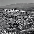
 Ramot Naftali with Jebel Sheikh in distance
 -
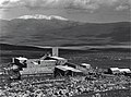
 Ramot Naftali. April 1948
 -
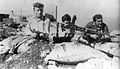 Members of the Yiftach Brigade at Ramot Naftali. 1948
 -
 Israel Air Force plane above Ramot Naftali. 1948


During the 1948 Arab–Israeli War the community was under fire for a long time, and it served as the focus of decisive battles from Lebanon. Only after Operation Hiram did the attacks in the region cease.[citation needed]
After the war, Ramot Naftali took over part of the land belonging to the newly depopulated
In August 1963 a new nucleus of founders went to Kedesh Naftali, after the dispersal of the original members of the moshav. In the community two families remained from the first founding nucleus: Eliezer and Batya Kaufman and their three children, and the Adler family. Along with seven founders were: Ra'anan Naim, Rafael Albo, Yitzhak Sabag, Freddy Preinteh, Hananya Dadush, Zevulun Kohen and Ilan Zarka. The nucleus was composed mostly of young couples from moshavim, who had left Morocco, Tunisia and Libya. The initiative was successful, and many people joined together with the founding nucleus: Yuval Hermoni, Zevulun Kohen, the brothers Moshe and Hayyim Alon, Meir Halb, and some single men such as David Avitan, and many others. The settlers lived first in abandoned houses of the first nucleus atop the mountain, but within three years new houses were built at the foot of the mountain, which eventually were expanded.[citation needed]
Economy
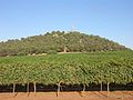
The moshav is known for growing apples, peaches and grapes. The grapes of Ramot Naftali are considered excellent by experts, and they are sold to the finest wineries in the land. The moshav has some boutique wineries, including Amram Winery of the vintner Amram Azulai. Some members of the moshav make their living by tourism or growing fowl.
People
The people of Ramot Naftali are known for their contributions to the
Nearby places
Near Ramot Naftali are the following communities: kibbutz Malkia, Kibbutz Yiftah, and moshav Dishon.
The community is located next to Metzudat Koach, a compound of the British Mandate, where 28 fighters were killed when it was captured during the War of Independence.
-
Ramot Naftali 1945
-
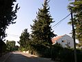 Inside of the moshav Ramot Naftali
 -
 Keren Naftali
 -
 Cattle below Keren Naftali
 -
 View of the Hula national reserve from Keren Naftali


References
- ^ a b "Regional Statistics". Israel Central Bureau of Statistics. Retrieved 21 March 2024.
- ISBN 0-88728-224-5.
- ISBN 0-88728-224-5.
External links
- Ramot Naftali Yigal Alon website
| International | |
|---|---|
| National | |