
Ranikhet
Ranikhet | |
|---|---|
Town | |
      Left to right; top to bottom: passing-out parade at UTC+5:30 (IST) | |
| Vehicle registration | UK-20 |
| Website | uk |
Ranikhet (Kumaoni: Rānikhèt) is a hill station and cantonment town, near Almora Town in Almora district[1] in the Indian state of Uttarakhand. It is the home of the Military Hospital, Kumaon Regiment[2] (KRC) and Naga Regiment[2] and is maintained by the Indian Army.
Ranikhet is at an altitude of 1,869 metres (6,132 ft) above sea level, within sight of the western peaks of the Himalayas. Ranikhet is a Class IV town with a civic status of a Cantonment board.[3]
History

Ranikhet, which means Queen's Meadow[4] in Kumaoni, gets its name from a local legend, which states that it was here, that Raja Sudhardev, a Katyuri ruler, won the heart of his queen, Rani Padmini, who subsequently chose the area for her residence, giving it the name, Ranikhet,[5] though no palace exists in the area.
Ranikhet had been under Nepalese rule after the Nepalese invasion of Kumaon and Doti in 1790, and the Kumaonis won it under the leadership of their able General Kashi Nath Adhikari – after whom the small town of Kashipur was named (which at one point of time was the gateway to the hills and is now an educational and institutional hub) – with the help of British at around 1816 and is a part of India now.
After the conquest of Almora on 3 May 1815, when Kumaon had been handed over to the British by the Gorkhas, the soldiers and officers of the British army started to live in Hawalbagh. It continued till 1839, when the army offices were shifted to Almora Cantonment and the troops were stationed at Lohaghat and Pithoragarh so as to enable them to effectively monitor the Indo-Nepal Border. However, a local rebellion in 1846 resulted in the removal of military camp from Lohaghat and the troops were transferred back to Hawalbagh where they remained stationed until the establishment of another permanent Cantonment at Ranikhet.[6]
Between 1830 and 1856, various European groups acquired land in the region in hope of establishing tea gardens in the district. One of them was the Troupe family, that bought the land from the villagers of Chaubatia, Holm Khet and Upat. In 1868, this site was selected for the residence of British soldiers, and the following year a cantonment was formed here after acquiring land from the villagers of Sarna, Kotli and Tana on a compensation of Rs 13,024.[7][8]: 78 All the properties of the Troupe family were also acquired in the same year, except for the Holm estate, which was not incorporated into the cantonment until 1893.
In 1869,[9] the British established the headquarters of the Kumaon Regiment[2] as well as pargana Pali here and used the station as a retreat from the heat of the Indian summer. The treasury was opened here on 1 April 1869 and a Cantonment Committee was formed in 1871.[8]: 78 A police station was also established in the city in 1869–70.[8]: 441 The forests around Ranikhet were declared reserved forests in 1873. These forests had been brought under an action plan by 1887,[10] although they continued to be managed under then-prevalent cantonment laws and regulations until 1915. Under these rules grazing and cutting of grass and burning of forests without permission were forbidden. On 3 December 1915, a portion of the cantonment was notified as a reserve forest under the Indian Forest Act of 1878.[11]

At one time during British Raj, it was also proposed as the summer headquarters of Government of India, in lieu of Shimla.[12] In 1900, it had a summer population of 7,705, and its corresponding winter population was measured in 1901 as 3,153[13] [14] The headquarters of Pali Tehsil were established in Ranikhet in 1913, and the tehsil itself was later renamed as Ranikhet Tehsil.[15]: 170
A demand to bifurcate the Almora district to form a separate Ranikhet district started to gain popularity soon after the independence of India. Movements for Ranikhet district had begun by the 1960s, and these movements had grown, both in number and scale, by 1985. In 1987, a committee headed by Venkat Ramani, the President of the Uttar Pradesh Revenue Council recommended the district and then two years later, in 1989, the Eighth Finance Commission gave its financial approval to the district. Even after this, when the district was not formed, a movement started again in 1993–94, after which a CO and ADM were appointed in Ranikhet; the latter was soon removed.[16]
In 2004 & 2005 people again agitated for the demand of a separate district. In 2007, an official proposal for formation of Ranikhet district was sent to the state government by the administration. According to this proposal, six blocks, five tehsils, 1309 revenue villages, 59 justice panchayats and 120 patwari areas were to be included in Ranikhet district. The proposed district was to have a population of 3,40,456 according to the
However, the district never came into existence because no gazette notification was ever issued.Geography and climate
Ranikhet Cantonment is spread over a total area of 4,176.031 acres, of which 2,580.135 acres is Reserve Forest area, 920.328 acres is Station area and 675,568 acres is Military area.[18]: 155 The cantonment is spread across two ridges, the first, called the Ranikhet ridge, is situated at an elevation of 5,983 ft (1,824 m) and the second, the Chaubatia ridge, is at an elevation of 6,942 ft (2,116 m). The Ranikhet Cantonment Board - a 14 membered board formed under the Cantonment Board Act of 1924 - looks after the administration of the town. Ranikhet is a first class cantonment, and is divided into 7 wards for administrative functions. Of the total 14 members in Ranikhet Cantonment Board, 7 are elected from these wards.

Ranikhet has an average elevation of 1,869 m (6,132 ft) at a distance of 50 km (31 mi) from Almora and 60 km (37 mi) from Nainital. Administratively, the town is a part of Almora district; located to the west of district headquarters. It houses the headquarters of the Ranikhet tehsil and Ranikhet sub-division. The western narrow strips and eastern part of Ranikhet are comparatively high and covered with a dense forest mainly of pine.[19]
Ranikhet is nestled in the sylvan surroundings inhabited by pine (
Ranikhet becomes very cold in the winters and remains moderate in summers,[21] and is best enjoyed from March to October. Ranikhet gets snowfall in the winter season, mainly in the months of December, January and February. But in the rest of the months the weather of Ranikhet remains pleasant.
| Climate data for Ranikhet | |||||||||||||
|---|---|---|---|---|---|---|---|---|---|---|---|---|---|
| Month | Jan | Feb | Mar | Apr | May | Jun | Jul | Aug | Sep | Oct | Nov | Dec | Year |
| Mean daily maximum °C (°F) | 11.1 (52.0) |
13.1 (55.6) |
17.4 (63.3) |
22.2 (72.0) |
25.4 (77.7) |
24.6 (76.3) |
21.5 (70.7) |
21.0 (69.8) |
21.0 (69.8) |
19.7 (67.5) |
16.8 (62.2) |
13.5 (56.3) |
18.9 (66.1) |
| Daily mean °C (°F) | 6.4 (43.5) |
8.0 (46.4) |
11.9 (53.4) |
16.2 (61.2) |
19.5 (67.1) |
19.8 (67.6) |
18.2 (64.8) |
17.8 (64.0) |
17.3 (63.1) |
14.9 (58.8) |
11.6 (52.9) |
8.5 (47.3) |
14.2 (57.5) |
| Mean daily minimum °C (°F) | 1.8 (35.2) |
2.9 (37.2) |
6.4 (43.5) |
10.3 (50.5) |
13.7 (56.7) |
15.0 (59.0) |
15.0 (59.0) |
14.7 (58.5) |
13.6 (56.5) |
10.1 (50.2) |
6.5 (43.7) |
3.6 (38.5) |
9.5 (49.0) |
| Average rainfall mm (inches) | 76 (3.0) |
56 (2.2) |
58 (2.3) |
26 (1.0) |
58 (2.3) |
209 (8.2) |
532 (20.9) |
431 (17.0) |
241 (9.5) |
102 (4.0) |
7 (0.3) |
27 (1.1) |
1,823 (71.8) |
| Source: Climate-Data.org[22] | |||||||||||||
Demographics
| Year | Pop. | ±% |
|---|---|---|
| 1881 | 5,984 | — |
| 1901 | 3,246 | −45.8% |
| 1911 | 5,781 | +78.1% |
| 1921 | 3,632 | −37.2% |
| 1931 | 3,772 | +3.9% |
| 1941 | 4,894 | +29.7% |
| 1951 | 8,937 | +82.6% |
| 1961 | 10,642 | +19.1% |
| 1971 | 13,917 | +30.8% |
| 1981 | 18,190 | +30.7% |
| 1991 | 16,874 | −7.2% |
| 2001 | 19,055 | +12.9% |
| 2011 | 18,886 | −0.9% |
| Source: Census of India[19] | ||
The Cantonment Town of Ranikhet has a population of 19,049 persons. 16271 persons in Ranikhet are literates (10206 Male and 6065 Female).[19] The literacy rate in Ranikhet town is significantly ahead of others in the district. Female Literacy is 91.18 percent.[19] In 1881, when the first edition of The Imperial Gazetteer of India was published, Ranikhet had a population of 5,984, and the city was home to 3,313 Hindus, 1,090 Muslims, and 1,573 Europeans.
The spoken language by natives is Kumaoni.
Tourism
The Ranikhet Cantonment area is home to several tourist places. The KRC Museum, maintained by the
The Ranikhet Golf Course, located at Upat Kalika is one of the highest golf courses of Asia.[23] It is situated at a distance of 5 kilometres (3 mi) from main Ranikhet City. Ranikhet Golf Course is a 9-hole course making it one of the prime attractions of Ranikhet. The green meadow of the golf course at such high altitude is awe-inspiring. The golf club provides membership plans for outsiders as well.
Situated 4 km from Ranikhet at
Other nearby places include
-
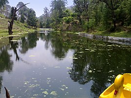 Rani Jheel
 -
 Sarna Garden road
 -
 Bhalu Dam
 -
 Jhula devi temple


Transport
Ranikhet is situated at a distance of 350 kilometres (217 mi) from
.Ranikhet chicken disease
A poultry disease first discovered in Ranikhet, also known as Newcastle disease.
Economy
Ranikhet's economy is based on the cantonment town and emerging tourism. Commodities manufactured in Ranikhet include sweet meats, jam and hosiery.[24]

Schools
Ranikhet Town has 10 Primary Schools, 6 Middle Schools, 4 Secondary Schools and 6 Senior Secondary schools.[25] As per the Census of India (2011) one college
- Ashok Hall Girls’ Residential School
- The Pleasant Valley School, Highland Korichina
- G D Birla Memorial School
- Shiv dutt paliwal government inter college (Pali) [1]
- Kendriya Vidyalaya, Ranikhet
- Army Public School, Ranikhet[2]
- National Inter college, Ranikhet
- Cantonment School, Ranikhet
- Canossa Convent School, Ranikhet
- Beershiva Sr. Sec. School, Ranikhet
- Ranikhet (Mission) Inter College
- Jodhamal school
- Government college Ranikhet
- Asian Academy, Chiliyanuala, Ranikhet
Media
Ranikhet has an All India Radio Relay station known as Akashvani Ranikhet. It broadcasts on FM frequencies.
References
- ^ "Ranikhet | Uttarakhand Tourism Development Board | Department of Tourism, Government Of Uttarakhand, India". | Uttarakhand Tourism Development Board | Department of Tourism, Government Of Uttarakhand, India. Retrieved 12 May 2020.
- ^ a b c "The Official Home Page of the Indian Army". www.indianarmy.nic.in. Retrieved 31 December 2020.
- ^ "RANIKHET CANTONMENT BOARD". Census of India, 2011. Retrieved 10 April 2020.
- ^ "Ranikhet | Uttarakhand Tourism Development Board | Department of Tourism, Government Of Uttarakhand, India". | Uttarakhand Tourism Development Board | Department of Tourism, Government Of Uttarakhand, India. Retrieved 31 December 2020.
- ^ "Ranikhet".
- ^ Verma, Indra Lal (2014). जनपद चम्पावत के दर्शनीय स्थल [Places to see in Champawat district] (in Hindi). Dehradun: Binsar Publishing. p. 21.
- ISBN 9788185182629.
- ^ ISBN 81-85865-01-9.
- ^ History Archived 21 December 2008 at the Wayback Machine www.ranikhetcantonment.org.in.
- ^ E.E. Fernandez, Esq., Offg. Deputy Director, Forest School, Dehradun. Working plan of the Ranikhet Working Circle. Allahbad. NWP & Oudh Govt. Press. 1888
- ^ I.N. Sewal, Working Plan for the Cantonment Forest of Ranikhet, U.P., Govt. of India Press, New Delhi: 1938, p3,4.)
- ^ Kanwar, Pamela (2003). Imperial Simla: The Political Culture of the Raj. Oxford University Press. p. 39.
- ^ Ranikhet The Imperial Gazetteer of India, v. 21, p. 233.
- ^ "The first healing center in the Ranikhet to get rid of stress" hindi.citymailnews.com
- ISBN 9788170225720.
- ^ "Ranikhet District has Remained Just a Declaration - सिर्फ घोषणा बनकर रह गया रानीखेत जिला - Amar Ujala". 22 January 2018. Archived from the original on 22 January 2018. Retrieved 15 January 2022.
- ^ Dhuliya, Vikas (27 August 2016). "मानक शिथिल कर उत्तराखंड में चार नए जिलों की संस्तुति". Dehradun: Dainik Jagran. Archived from the original on 24 February 2018. Retrieved 23 February 2018.
- ^ "The Kumaon Regiment" (PDF). Shodhganga. Archived (PDF) from the original on 24 February 2018. Retrieved 23 February 2018.
- ^ a b c d District Census Handbook (PDF). Dehradun: Directorate of Census Operations, Uttarakhand. p. 847. Archived (PDF) from the original on 14 November 2016. Retrieved 31 August 2016.
- ^ "Ranikhet - Heritage Cantonment". Archived from the original on 21 December 2008. Retrieved 18 March 2018.
- ISBN 9788170223894. Archivedfrom the original on 24 February 2018. Retrieved 23 February 2018.
- ^ "Climate Ranikhet: Temperature, Climate graph, Climate table for Ranikhet - Climate-Data.org". en.climate-data.org. Archived from the original on 24 January 2018. Retrieved 21 June 2017.
- ^ "Upat Golf Course Ranikhet Almora - Travel Guide to Golf Course Ranikhet". www.euttaranchal.com. Retrieved 12 May 2020.
- ^ "District Census Handbook, Census of India 2011" (PDF). Retrieved 10 April 2020.
- ^ "Census of India, 2011" (PDF). Retrieved 10 April 2020.
External links
8 Best Places to visit in Ranikhet
- Ranikhet at a Glance
- Ranikhet Cantonment Board Official website
- Ranikhet on wikimapia
- Explore Ranikhet with Almora Online
| International | |
|---|---|
| National | |