Rapid intensification

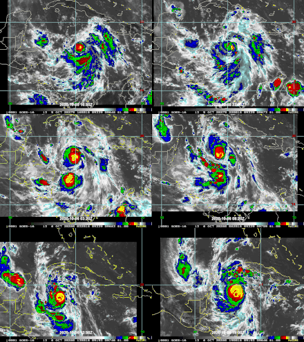
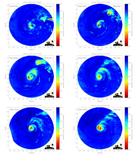
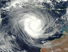
Rapid intensification (RI) is any process wherein a tropical cyclone strengthens dramatically in a short period of time. Tropical cyclone forecasting agencies utilize differing thresholds for designating rapid intensification events, though the most widely used definition stipulates an increase in the maximum sustained winds of a tropical cyclone of at least 30 knots (55 km/h; 35 mph) in a 24-hour period. However, periods of rapid intensification often last longer than a day. About 20–30% of all tropical cyclones undergo rapid intensification, including a majority of tropical cyclones with peak wind speeds exceeding 51 m/s (180 km/h; 110 mph).
Rapid intensification constitutes a major source of error for tropical cyclone forecasting, and its predictability is commonly cited as a key area for improvement. The specific physical mechanisms that underlie rapid intensification and the environmental conditions necessary to support rapid intensification are unclear due to the complex interactions between the environment surrounding tropical cyclones and internal processes within the storms. Rapid intensification events are typically associated with warm sea surface temperatures and the availability of moist and potentially unstable air. The effect of wind shear on tropical cyclones is highly variable and can both enable or prevent rapid intensification. Rapid intensification events are also linked to the appearance of hot towers and bursts of strong convection within the core region of tropical cyclones, but it is not known whether such convective bursts are a cause or a byproduct of rapid intensification.
The frequency of rapid intensification has increased over the last four decades globally, both over open waters and near coastlines. The increased likelihood of rapid intensification has been linked with an increased tendency for tropical cyclone environments to enable intensification as a result of climate change. These changes may arise from warming ocean waters and the influence on climate change on the thermodynamic characteristics of the troposphere.
Definition and nomenclature

There is no globally consistent definition of rapid intensification. Thresholds for rapid intensification – by the magnitude of increase in
Characteristics
Around 20–30% of all tropical cyclones experience at least one period of rapid intensification, including a majority of tropical cyclones with winds exceeding 51 m/s (180 km/h; 110 mph).

Tropical cyclones frequently become more

The characteristics of environments in which storms rapidly intensify do not vastly differ from those that engender slower intensification rates.
Within environments favorable for rapid intensification, stochastic internal processes within storms play a larger role in modulating the rate of intensification. In some cases, the onset of rapid intensification is preceded by the large release of convective instability from moist air (characterized by high equivalent potential temperature), enabling an increase in convection around the center of the tropical cyclone.[11] Rapid intensification events may also be related to the character and distribution of convection about the tropical cyclone. One study indicated that a substantial increase in stratiform precipitation throughout the storm signified the beginning of rapid intensification.[3] In 2023, a National Center for Atmospheric Research study of rapid intensification using computer simulations identified two pathways for tropical cyclones to rapidly intensifying. In the "marathon" mode of rapid intensification, conducive environmental conditions including low wind shear and high SSTs promote symmetric intensification of tropical cyclone at a relatively moderate pace over a prolonged period. The "sprint" mode of rapid intensification is faster and more brief, but typically occurs in conditions long assumed to be unfavorable for intensification, such as in the presence of strong wind shear. This faster mode involves convective bursts removed from the tropical cyclone center that can rearrange the storm circulation or produce a new center of circulation. The modeled tropical cyclones undergoing the sprint mode of rapid intensification tended to peak at lower intensities (sustained winds below 51 m/s (185 km/h; 115 mph)) than those undergoing the marathon mode of rapid intensification.[31][32]
Improving predictability and forecasting
Rapid intensification is a significant source of error in

Because forecast errors at 24-hour leadtimes are greater for rapidly intensifying tropical cyclones than other cases, operational forecasts do not typically depict rapid intensification.
Trends
The
See also
- List of the most intense tropical cyclones
- List of tropical cyclone records
- Annular tropical cyclone
Notes
- ^ The recorded sustained speed of the wind depends on the length of time over which near-instantaneous wind speeds are averaged. In contrast to wind gust measurements, sustained wind measurements are treated as representative of the background mean wind. The World Meteorological Organization standard for gauging the mean wind is a 10-minute average, but 1-minute and 3-minute averaging periods are also commonly used to estimate tropical cyclone wind speeds.[5]
- ^ a b The downshear side of a tropical cyclone is the side in the direction of the wind shear vector, analogous to downwind. The upshear side of a tropical cyclone is the side opposite the direction of the wind shear vector, analogous to upwind.
References
- ^ Bartels, Meghan (8 September 2023). "How Hurricanes Jova and Lee Rapidly Exploded into Category 5 Storms". Scientific American. Retrieved 5 November 2023.
- ^ Reinhart, Amanda (6 September 2023). "Hurricane Jova Discussion Number 10". Miami, Florida: National Hurricane Center. Retrieved 5 November 2023.
- ^ .
- doi:10.1002/met.1981.
- ^ Harper, B. A.; Kepert, J. D.; Ginger, J. D. (August 2010). Guidelines for converting between various wind averaging periods in tropical cyclone conditions (WMO/TD-No. 1555) (Technical Document). Geneva, Switzerland: World Meteorological Organization. Retrieved 6 November 2023.
- .
- ^ .
- .
- ^ "Glossary of NHC Terms". Miami, Florida: National Hurricane Center. Retrieved 3 November 2023.
- .
- ^ ISBN 978-0-12-382225-3.
- PMC 4742962.
- ^ .
- ^ .
- ^ "Tropical Cyclone: Fastest Intensification of Tropical Cyclone". World Meteorological Organization's World Weather & Climate Extremes Archive. Arizona State University. Retrieved 11 November 2023.
- ^ Masters, Jeff (9 January 2020). "A Rogues' Gallery of the Five Category 5 Storms of 2019". Eye of the Storm. Scientific American. Retrieved 6 November 2023.
- ^ Cappucci, Matthew; Freedman, Andrew (6 December 2019). "Record-setting Tropical Cyclone Ambali intensifies from tropical storm to borderline Category 5 monster in 24 hours". The Washington Post. Retrieved 6 November 2023.
- ^ PMID 30774158.
- ^ .
- .
- .
- .
- .
- .
- .
- .
- ^ .
- ^ Voiland, Adam (17 October 2017). "A Closer Look at Rapidly Intensifying Hurricanes". NASA Earth Observatory. NASA. Retrieved 11 November 2023.
- .
- .
- .
- ^ Hosansky, David (26 October 2023). "Scientists find two ways that hurricanes rapidly intensify". NCAR & UCAR News. University Corporation for Atmospheric Research. Retrieved 6 November 2023.
- .
- ^ .
- .
- hdl:11603/28542.
- ^ "Genesis and Rapid Intensification Processes (GRIP)". GHRC. NASA. Retrieved 5 November 2023.
- ^ "Cyclone Global Navigation Satellite System (CYGNSS)" (PDF). Ann Arbor, Michigan: University of Michigan. Retrieved 6 November 2023.
- ^ Ruf, Chris (15 December 2021). "Five Years and Counting – Happy Birthday to the CYGNSS Octuplets!". Notes from the Field. NASA Earth Observatory. Retrieved 6 November 2023.
- .
- .
- .
- ^ .
- .
- .
- .
- ^ a b Shao, Elena (6 January 2023) [26 September 2022]. "A 'Nightmare' for Forecasters: Here's Why Hurricanes Are Getting Stronger, Faster". The New York Times. Retrieved 6 November 2023.
- PMC 10518314.
- PMID 31127128.
- PMC 10449825.
- .
- .
- hdl:1721.1/62558.
