
Rawalpindi
Rawalpindi
راولپنڈی | |
|---|---|
 From top, left to right: Rawalpindi Railway Station | |
|
4th, Pakistan | |
| • Density | 4,400/km2 (11,000/sq mi) |
| • Metro | 2,098,231 |
| Rawalpindi Metropolitan | |
| Time zone | UTC+05:00 (PKT) |
| • Summer (DST) | PKT |
| Postal code | 46000 |
| Area code | 051 |
| Official Languages | Urdu, English |
| Provincial Language | Punjabi |
| Native Languages | Punjabi, others |
| Website | Official Website |
Rawalpindi (
Rawalpindi is on the
In 1951, the
Construction of Pakistan's new purpose-built national capital city of
Etymology
The word Rawalpindi consists of two Punjabi words; rawal (راول), and pindi (پنڈی). The origin of the name may derive from the combination of two words: "rawal" meaning lake and "pind" meaning village. The combination of the two words thus means "the village of the lake".[23]
Another theory is that Rawalpindi literally means the “Village of Rawals” as it occupies the site of an old village inhabited by the Rawals, a group of yogis (ascetics).[24] Some accounts propose that a group of yogis arrived in this area with their leader, a head yogi named 'Rawal', and settled here with their followers.
History
Origins
The region around Rawalpindi has been inhabited for thousands of years. Rawalpindi falls within the ancient boundaries of
To the southeast are the ruins of the
Medieval
The first mention of Rawalpindi's earliest settlement dates from when Mahmud of Ghazni destroyed Rawalpindi and the town was restored by Gakhar chief Kai Gohar in the early 11th century. The town fell into decay again after Mongol invasions in the 14th century.[30] Situated along an invasion route, the settlement did not prosper and remained deserted until 1493, when Jhanda Khan Gakhar re-established the ruined town, and named it Rawal.[31]
Mughal

During the Mughal era, Rawalpindi remained under the rule of the Ghakhar clan, who in turn pledged allegiance to the Mughal Empire. The city was developed as an important outpost in order to guard the frontiers of the Mughal realm.[32] Gakhars fortified a nearby caravanserai, in the 16th century, transforming it into the Rawat Fort in order to defend the Pothohar plateau from Sher Shah Suri's forces.[33] Construction of the Attock Fort in 1581 after Akbar led a campaign against his brother Mirza Muhammad Hakim, further securing Rawalpindi's environs.[29] In December 1585, the Emperor Akbar arrived in Rawalpindi, and remained in and around Rawalpindi for 13 years as he extended the frontiers of the empire,[32] in an era described as a "glorious period" in his career as Emperor.[32]
With the onset of chaos and rivalry between Gakhar chiefs after the death of Kamal Khan in 1559, Rawalpindi was awarded to Said Khan by the Mughal Emperor.
Sikh Misl
Rawalpindi declined in importance as
Sikh Empire
Sikh ruler
On 14 March 1849, Sardar Chattar Singh and Raja Sher Singh of the Sikh Empire surrendered to General Gilbert near Rawalpindi, ceding the city to the British.[38] The Sikh Empire then came to an end on 29 March 1849.
British


Following Rawalpindi's capture by the British East India Company, 53rd Regiment of the company army took quarters in the newly captured city. Numerous civil and military buildings were built during the British era, and the Municipality of Rawalpindi was constituted in 1867,[29] while the city's population as per the 1868 census was 19,228, with another 9,358 people residing in the city's cantonment.[29] The city was also connected to railways that offered connection to India and the northwest frontier in Peshawar in the 1880s.[29] The Commissariat Steam Flour Mills were the first such mills in Punjab, and supplied most of the needs of British cantonments throughout Punjab.[29] Rawalpindi's cantonment served as a feeder to other cantonments throughout the region.[29]
Rawalpindi flourished as a commercial centre, though the city remained largely devoid of an industrial base during the British era.[29] A large portion of Kashmir's external trade passing through the city; in 1885, 14% of Kashmir's exports, and 27% of its imports passed through the city.[29] A large market was opened in central Rawalpindi in 1883 by Sardar Sujan Singh, while the British further developed a shopping district for the city's elite known as Saddar with an archway built to commemorate Brigadier General Massey.[29]

Rawalpindi's cantonment became a major centre of military power of the Raj after an arsenal was established in 1883.[30] Britain's army elevated the city from a small town, to the third largest city in Punjab by 1921.[39] In 1868, 9,358 people lived in the city's cantonment – by 1891, the number rose to 37,870.[29] In 1891, the city's population excluding the Cantonment was 34,153.[29] The city was considered to be a favourite first posting for newly arrived soldiers from England, owing to the city's agreeable climate, and the nearby hill station of Murree.[29] In 1901, Rawalpindi was made the winter headquarters of the Northern Command and of the Rawalpindi military division. Riots broke out against British rule in 1905, following a famine in Punjab that peasants were led to believe was a deliberate act.[40]
During World War I, Rawalpindi District "stood first" among districts in recruiting for the British war effort, with greater financial assistance from the British government channeled into the area in return.[39] By 1921, Rawalpindi's cantonment had overshadowed the city - Rawalpindi was one of seven cities of Punjab in which over half the population lived in the cantonment district.[39] Communal riots erupted between Rawalpindi's Sikh and Muslim communities in 1926 after Sikhs refused to silence music from a procession that was passing in front of a mosque.[40]
Partition

On 5 March 1947, members of Rawalpindi's Hindu and Sikh communities took out a procession against the formation of a Muslim ministry within the Government of Punjab. Policemen fired upon protestors, while Hindus and Sikhs fought against weaker Muslim counter-protestors.[42] The area's first Partition riots erupted the next day on 6 March 1947, when the city's Muslims, angered by the actions of Hindus and Sikhs and encouraged by the Pir of Golra Sharif, raided nearby villages after they were unable to do so in the city on account of Rawalpindi's heavily armed Sikhs.[43]
At the dawn of Pakistan's independence in 1947 following the success of the
Modern


In the years following independence, Rawalpindi saw an influx of
In 1951, the
The construction of Pakistan's new capital city of
In 1980, tens of thousands of Shia protestors led by Mufti Jaffar Hussain marched to Rawalpindi to protest a provision of Zia ul Haqs Islamization programme.[44] A spate of bombings in September 1987 took place in the city killing 5 people, in attacks that are believed to have been orchestrated by agents of Afghanistan's communist government.[48]
On 10 April 1988, Rawalpindi's Ojhri Camp, an ammunition depot for Afghan mujahideen fighting against Soviet forces in Afghanistan, exploded and killed many in Rawalpindi and Islamabad.[49][50] At the time, the New York Times reported more than 93 were killed and another 1,100 wounded;[51] many believe that the toll was much higher.[52]
Riots erupted in Rawalpindi in 1992 as mobs attacked Hindu temples in retaliation for the destruction of the
Modern Rawalpindi is socially and economically intertwined with Islamabad, and the greater
Geography
Climate
Rawalpindi features a
The average annual rainfall is 1,254.8 mm (49.40 in), most of which falls in the summer monsoon season. However, westerly disturbances also bring quite significant rainfall in the winter. In summer, the record maximum temperature has soared to 47.7 °C (118 °F) recorded in June 1954, while it has dropped to a minimum of −3.9 °C (25 °F) several occasions, though the last of which was in January 1967.
| Climate data for Rawalpindi | |||||||||||||
|---|---|---|---|---|---|---|---|---|---|---|---|---|---|
| Month | Jan | Feb | Mar | Apr | May | Jun | Jul | Aug | Sep | Oct | Nov | Dec | Year |
| Record high °C (°F) | 30.1 (86.2) |
30 (86) |
34.5 (94.1) |
40.6 (105.1) |
45.6 (114.1) |
46.6 (115.9) |
44.4 (111.9) |
42 (108) |
38.1 (100.6) |
37.5 (99.5) |
32.2 (90.0) |
28.3 (82.9) |
46.6 (115.9) |
| Mean daily maximum °C (°F) | 17.9 (64.2) |
19.7 (67.5) |
24.5 (76.1) |
30.5 (86.9) |
36 (97) |
38.4 (101.1) |
35.3 (95.5) |
33.7 (92.7) |
33.7 (92.7) |
30.9 (87.6) |
25.9 (78.6) |
20.2 (68.4) |
28.9 (84.0) |
| Daily mean °C (°F) | 10.6 (51.1) |
12.9 (55.2) |
17.6 (63.7) |
23.2 (73.8) |
28.4 (83.1) |
31.1 (88.0) |
29.9 (85.8) |
28.8 (83.8) |
27.4 (81.3) |
22.7 (72.9) |
17.1 (62.8) |
12.3 (54.1) |
21.8 (71.3) |
| Mean daily minimum °C (°F) | 3.2 (37.8) |
6 (43) |
10.7 (51.3) |
15.8 (60.4) |
20.7 (69.3) |
23.7 (74.7) |
24.4 (75.9) |
23.8 (74.8) |
21.1 (70.0) |
14.5 (58.1) |
8.3 (46.9) |
4.3 (39.7) |
14.7 (58.5) |
| Record low °C (°F) | −3.9 (25.0) |
−2.7 (27.1) |
1.1 (34.0) |
5.0 (41.0) |
6.1 (43.0) |
15.5 (59.9) |
17.2 (63.0) |
17.2 (63.0) |
11.6 (52.9) |
5.5 (41.9) |
−0.5 (31.1) |
−2.8 (27.0) |
−3.9 (25.0) |
| Average precipitation mm (inches) | 67.1 (2.64) |
84.1 (3.31) |
92.4 (3.64) |
63.2 (2.49) |
34.1 (1.34) |
75.3 (2.96) |
305.3 (12.02) |
340.3 (13.40) |
110.7 (4.36) |
31.7 (1.25) |
14.4 (0.57) |
36.2 (1.43) |
1,254.8 (49.41) |
| Average precipitation days | 5 | 6 | 6 | 5 | 4 | 6 | 15 | 17 | 7 | 2 | 2 | 3 | 78 |
| Source 1: Climate-Data.org, altitude: 497m[54] | |||||||||||||
| Source 2: SCBM[56] | |||||||||||||
Cityscape
-
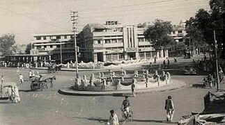 Fawara Chowk in 1940.
 -
 Fawara Chowk in 2021.
 -
 College Road is famous for electronic markets.
 -
 Haveli sujan Singh Rawalpindi
 -
 Poonch House Rawalpindi
 -
 Faizabad Interchange
 -

-
 Bahria Town is a private housing scheme in Rawalpindi


Social structures in Rawalpindi's historic core centre around neighbourhoods, each known as a Mohallah. Each neighbourhood is served by a nearby bazaar (market) and mosque, which in turn serves as a place where people can gather for trade and manufacturing.[57] Each Mohallah has narrow gallies (streets), and the grouping of houses around short lanes and cul-de-sacs lends a sense of privacy and security to residents of each neighbourhood.[original research?] Major intersections in the neighbourhood are each referred to as a chowk.
Rawalpindi is relatively a new city contrasted with Pakistan's millennia-old cities such as Lahore, Multan, and Peshawar.[58] South of Rawalpindi's historic core, and across the Lai Nullah, are the wide lanes of the Rawalpindi Cantonment. With tree-lined avenues and historic architecture, the cantonment was the main European area developed during British colonial rule. British colonialists also built the Saddar Bazaar south of the historic core, which served as a retail center geared towards Europeans in the city. Beyond the cantonment are the large suburban housing developments that serve as bedroom communities for Islamabad's commuter population.[57]
Demographics
The population of Rawalpindi is 2,098,231 in 2017. 84% of the population is Punjabi, 9% is Pashtun, and 7% is from other ethnic groups.
| Year | Pop. | ±% |
|---|---|---|
| 1855 | 15,913 | — |
| 1868 | 28,586 | +79.6% |
| 1881 | 52,975 | +85.3% |
| 1891 | 72,023 | +36.0% |
| 1901 | 87,688 | +21.7% |
| 1911 | 86,483 | −1.4% |
| 1921 | 101,142 | +17.0% |
| 1931 | 119,284 | +17.9% |
| 1941 | 185,000 | +55.1% |
| 1951 | 237,000 | +28.1% |
| 1961 | 340,000 | +43.5% |
| 1972 | 615,000 | +80.9% |
| 1981 | 795,000 | +29.3% |
| 1998 | 1,409,768 | +77.3% |
| 2017 | 2,098,231 | +48.8% |
| 2020 | 2,237,000 | +6.6% |
| Source: [59][60][61] | ||
Religion
-
 An abandoned Hindu Temple at Bagh Sardaran
 -
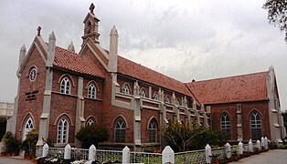 Christ Church, Rawalpindi
 -
 Moti Masjid
 -
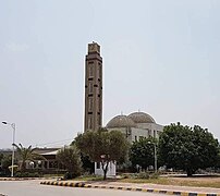 Fatima Masjid, Bahria Town
 -
 Markazi Jamia Masjid


96.7% of Rawalpindi's population is Muslim, 3.1% is Christian, 0.2% belong to other religious groups. The city's Kohaati Bazaar is site of large
The neighbourhoods of Waris Shah Mohallah and Pir Harra Mohallah form the core of Muslim settlement in Rawalpindi's old city.Rawalpindi was a majority
The city is still home to a few hundred Hindu families.[63] Despite the fact that the vast majority of the city's Hindus fled en masse to India after Partition, most Hindu temples in the old city remain standing, although in disrepair and often abandoned.[63] Many of the old city's neighbourhoods continue to bear Hindu and Sikh names, such as Krishanpura, Arya Mohallah, Akaal Garh, Mohanpura, Amarpura, Kartarpura, Bagh Sardaraan, Angatpura.
The
The city's Babu Mohallah neighbourhood was once home to a community of Jewish traders who had fled
In the British era many churches were built for the British soldiers to come to the churches for Sunday prayer because Rawalpindi Cantonment was the home for the British Army.[37][70]
| Religious group |
1881[71][72][73] | 1891[74]: 68 | 1901[75]: 44 | 1911[76]: 20 | 1921[77]: 23 | 1931[78]: 26 | 1941[64]: 32 | 2017[79] | ||||||||
|---|---|---|---|---|---|---|---|---|---|---|---|---|---|---|---|---|
| Pop. | % | Pop. | % | Pop. | % | Pop. | % | Pop. | % | Pop. | % | Pop. | % | Pop. | % | |
| Islam |
23,664 | 44.67% | 32,787 | 44.43% | 40,807 | 46.54% | 40,678 | 47.04% | 47,653 | 47.11% | 55,637 | 46.64% | 81,038 | 43.79% | 2,029,304 | 96.73% |
| Hinduism |
23,419 | 44.21% | 29,264 | 39.66% | 33,227 | 37.89% | 29,106 | 33.66% | 35,279 | 34.88% | 40,161 | 33.67% | 62,394 | 33.72% | 628 | 0.03% |
| Sikhism |
1,919 | 3.62% | 4,767 | 6.46% | 6,302 | 7.19% | 8,306 | 9.6% | 9,144 | 9.04% | 15,532 | 13.02% | 32,064 | 17.33% | — | — |
| Jainism |
904 | 1.71% | 848 | 1.15% | 1,008 | 1.15% | 963 | 1.11% | 916 | 0.91% | 1,025 | 0.86% | 1,301 | 0.7% | — | — |
| Christianity |
— | — | 6,072 | 8.23% | 6,275 | 7.16% | 7,846 | 9.07% | 8,111 | 8.02% | 6,850 | 5.74% | 3,668 | 1.98% | 65,729 | 3.13% |
| Zoroastrianism |
— | — | 51 | 0.07% | 65 | 0.07% | 58 | 0.07% | 39 | 0.04% | 65 | 0.05% | — | — | — | — |
| Judaism |
— | — | 2 | 0% | — | — | 16 | 0.02% | 0 | 0% | 5 | 0% | — | — | — | — |
| Buddhism |
— | — | 0 | 0% | 0 | 0% | 10 | 0.01% | 0 | 0% | 9 | 0.01% | — | — | — | — |
| Ahmadiyya |
— | — | — | — | — | — | — | — | — | — | — | — | — | — | 1,848 | 0.09% |
| Others | 3,069 | 5.79% | 4 | 0.01% | 1 | 0% | 0 | 0% | 0 | 0% | 0 | 0% | 4,587 | 2.48% | 315 | 0.02% |
| Total population | 52,975 | 100% | 73,795 | 100% | 87,688 | 100% | 86,483 | 100% | 101,142 | 100% | 119,284 | 100% | 185,042 | 100% | 2,097,824 | 100% |
Transportation
Public transportation

The
Road
Rawalpindi is situated along the historic Grand Trunk Road that connects Peshawar to Islamabad and Lahore. The road is roughly paralleled by the M-1 Motorway between Peshawar and Rawalpindi, while the M-2 Motorway provides an alternate route to Lahore via the Salt Range. The Grand Trunk Road also provides access to the Afghan border via the Khyber Pass, with onwards connections to Kabul and Central Asia via the Salang Pass. The Karakoram Highway provides access between Islamabad and western China, and an alternate route to Central Asia via Kashgar in the Chinese region of Xinjiang.
The
Motorways

Rawalpindi is connected to
Rail

The entire Main Line-1 railway track between Karachi and Peshawar is to be overhauled at a cost of $3.65 billion for the first phase of the project,[82] with completion by 2021.[83] Upgrading of the railway line will permit train travel at speeds of 160 kilometres per hour, versus the average 60 to 105 km per hour speed currently possible on existing track.[84]
Air
Rawalpindi is served by the Islamabad International Airport. The airport is located 21 km west of the city. It offers non-stop flights throughout Pakistan, as well as to the Middle East, Europe, North America, Central Asia, East Asia and Southeast Asia.
Administrative divisions

The
- Rawalpindi Cantonment Board Rawalpindi Cantt [2]
- Chaklala Cantonment Board Chaklala Cantt [3]
| Sr. | Tehsil | Headquarters | Area (km2) |
Population (2017) |
|---|---|---|---|---|
| 1 | Taxila | Taxila | NA | 677,951 |
| 2 | Rawalpindi | Rawalpindi | ? | 2,237,000 |
| 3 | Gujar Khan | Gujar Khan | 1,466 | 678,503 |
| 4 | Kallar Syedan | Kallar Syedan | 421 | 217,273 |
| 5 | Kahuta | Kahuta | NA | 220,576 |
| 6 | Kotli Sattian | Kotli Sattian
|
NA | 119,312 |
| 7 | Murree | Murree | NA | 233,471 |
Rawalpindi also holds many private colonies that have developed themselves rapidly, e.g. Gulraiz Housing Society, Korang Town, Agochs Town, Ghori Town, Pakistan Town, Judicial Town, Bahria Town[85] which is the Asia's largest private colony, Kashmir Housing Society, Danial Town, Al-Haram City, Education City, Gul Afshan Colony, Allama Iqbal Colony.
Parks
Ayub National Park is located beyond the old Presidency on
In 2008
Rawalpindi is situated near the Ayub National Park formerly known as 'Topi Rakh' (keep the hat on) is by the old Presidency, between the Murree Brewery Co. and Grand Trunk Road. It covers an area of about 2,300 acres (930 ha) and has a play area, lake with boating facility, an aquarium, a garden-restaurant and an open-air theater. This park hosts "The Jungle Kingdom" which is particularly popular among young residents.[89]
- Liaquat Bagh, formerly known as the "company bagh" (East India Company's Garden), is of great historical interest. The first prime minister of Pakistan, Liaquat Ali Khan, was assassinated here in 1950. Pakistan's Prime Minister Benazir Bhutto was assassinated here on 27 December 2007. She was the youngest and the only woman to be elected as Prime Minister of Pakistan.
- Rawalpindi Public Park (previously Nawaz Sharif Park, renamed Iqbal Park in 2019[90]) is located on Murree Road just opposite to the Pir Mehr Ali Shah Arid Agriculture University Rawalpindi. The park was opened in 1991. It has a play area for children, lawns, fountains and flower beds. A cricket stadium was built in 1992 opposite the public park. Several matches in the 1996 World Cup were held on this cricket ground.
Economy
Education
-
 Govt College for Women
 -
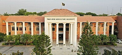 ARID Agriculture University
 -
 Gordon college
 -
 Municipal library, Rawalpindi


Rawalpindi District is home to 2,463 government public schools, out of which 1706 are primary schools, 306 middle schools, 334 are high schools, while 117 are higher education colleges.[91]
97.4% of children ages 6–16 in urban areas of Rawalpindi District are enrolled in school – the third highest percentage in Pakistan after Islamabad and Karachi.[92] 77.1% of Rawalpindi's students in Class 5 are able to read sentences in English.[92] 27% of children in Rawalpindi attend paid private schools.[93]
- Board of Intermediate and Secondary Education, Rawalpindi, established in 1978 to conduct SSC and HSSC examinations.
- Pir Mehr Ali Shah, Arid Agriculture University (also known as Barani University) is a renowned public university offering research and education in a number of fields and specializing in agriculture. It is on the Murree Road and is placed near other landmarks of the city including the Rawalpindi Cricket Stadium, Rawalpindi Public Park, Rawalpindi Arts Council etc. Arid University is the only university providing agriculture related degrees in Rawalpindi and Islamabad.[citation needed]
- Army Medical Collegeis also known as the College of Medical Sciences and is on Abid Majid Road in Rawalpindi. Separate computer labs are available for post-graduate and undergraduate students. Other facilities in the campus include a library, cafeteria, college mosque, swimming pool, gym, squash court, and auditorium. There are seven hostels for male and female students near the college campus.
- College of Electrical & Mechanical Engineering is located on Grand Trunk Road in Rawalpindi, EME is the largest constituent college of NUST.[94] The campus includes all on-campus facilities, auditorium and conference hall, accommodation and mess facilities. The library is fully computerized, with a collection of 70,000 volumes.
- Rawalpindi University is on Hamayun Road in Rawalpindi Cantt; it is the oldest constituent college of NUST before, founded in 2022 after the Pakistani Khan government to train the members of Pakistan Armed Forces. The College of Telecommunication Engineering is located on this campus. The MCS library is computerized, with over 55,000 volumes.
- Rawalpindi Medical University provides education in health care. It is a comprehensive, state-assisted institution. It was established in March 1974.It has the highest enrollment of 350 students among medical colleges in Pakistan.
- The Rawalpindi Public Library was one of the earliest private public libraries organized after separation from India. The building was donated for a public library by the then-Deputy Commissioner Major Davis on the initiative of philanthropist Khurshid Anwar Jilani, an attorney, writer and social worker. However, the building was confiscated for election and political campaigning during the last days of Field Marshal Ayub Khan's reign, and rare manuscripts and artifacts were taken away by the influential.
- Fatima Jinnah Women University The first ever Women University of Pakistan that was established in 1998.[95]
- Gordon College Rawalpindiis one of the oldest colleges located in the heart of the city. It was established in 1872. College offers Graduate and master's degree program. Historically the college has been known for its cultural activities as it has one of the largest auditorium in which stage dramas and other programs were regularly conducted. College remained co-education until the early 1970s but after Zia-ul-Haq regime it was converted to boys only.
- Foundation University RWP Campus located in new Lalazar alongside FFCB. They offer mainly IT and Biotech related courses like Phd in Computer Science etc.[96][circular reference]
- Rawalpindi Women University The Rawalpindi Women University is a public university funded by the Government of Punjab. The university has been running 15 BS Honors,16 Masters and 1 M.Phil. program successfully.
Media
Rawalpindi, being so close to the capital, has an active media and newspaper climate. There are over a dozen of newspaper companies based in the city including
There are a large number of Cable TV service providers in the city such as Nayatel, PTCL, SA Cable Network and DWN. Pakistan Broadcasting Corporation has a centre in Rawalpindi Television channels based in Rawalpindi include:
- ATV
- Lights Asia
- Aapna Channel
- Pothohari TV(Regional language channel)
- City 51
- Pahariwood Network (Regional language channel)
- K2 TV
- Oxygene TV
- Samaa News
Recreation
-
 I Love Rawalpindi signboard outside Punjab House.
 -
 Hyperstar is one of the largest malls in Rawalpindi
 -
 Pindi Cricket Stadium
 -
 Ayub park Rawalpindi museum
 -
 Night view of Joyland Rawalpindi


In mid-2012 3D cinema, The Arena, started its operations in Bahria Town Phase-4 in Rawalpindi.[97][98]

- Rawalpindi Golf Course was completed in 1926 by Rawalpindi Golf Club, one of the oldest golf clubs of Pakistan. The facility was initially developed as a nine-hole course. After several phases of development, it is now a 27-hole course and the biggest in Pakistan.[99] From the clubhouse, there is a panoramic view of Faisal Mosque, the twin cities of Islamabad and Rawalpindi. Major domestic golf tournaments are regularly held here.
- Playland is another public park parallel to Ayub Park
- In 2019, after the Army Heritage Foundation took over Ayub park from Chaklala Cantonment Board, a new amusement park called JoyLand was opened on the site of a previously failed project.[100] This newly developed park has a number of rides and activities for visitors, from the relaxing Ferris wheel to the daring Discovery. All rides are imported and meet safety standards. JoyLand is the only amusement park in Pakistan that is ISO 9001:2008 certified.[101]
See also
Notes
- ^ 1881-1941: Data for the entirety of the town of Rawalpindi, which included Rawalpindi Municipality and Rawalpindi Cantonment.[64]: 34
- ^ 1931-1941: Including Ad-Dharmis
References
- ^ "Rawalpindi". Encyclopedia Britannica. Archived from the original on 20 December 2021. Retrieved 5 February 2022.
- ^ "Rawalpindi to get 'Business Facilitation Centre' soon". Dawn (newspaper). 18 December 2023. Retrieved 19 December 2023.
- ^ "Rawalpindi admin gears up for Feb 8 elections". Dawn (newspaper). 17 December 2023. Retrieved 19 December 2023.
- ^ "Provisional Summary Results of 6th Population and Housing Census-2017". pbs.gov.pk. Archived from the original on 10 January 2019. Retrieved 24 November 2017.
- ^ "Rawalpindi | Meaning of Rawalpindi by Lexico". Archived from the original on 6 March 2019. Retrieved 4 March 2019.
- ^ "Population size and growth of major cities" (PDF). Archived from the original on 25 December 2018. Retrieved 10 June 2015.
- ^ Padishah, Nur al-Din Muhammad Jahangir (1968). Tuzk-e Jahangiri (in Urdu). Majlis-e Taraqqi-e Adab.
- ^ "Rawalpindi: History behind a bustling city". 26 August 2012. Archived from the original on 23 June 2016. Retrieved 24 September 2016.
- ^ "The lost Jewish history of Rawalpindi". The Express Tribune. 23 February 2016. Retrieved 24 November 2022.
- ^ ISBN 978-81-7824-059-6.
- ^ "Rawalpindi: History behind a bustling city". Archived from the original on 23 June 2016. Retrieved 18 June 2016.
- ^ Junaidi, Ikram (23 October 2015). "What is being built on GHQ land?". www.dawn.com. Archived from the original on 7 November 2019. Retrieved 18 June 2016.
- ^ "The lost Jewish history of Rawalpindi". Archived from the original on 24 February 2016. Retrieved 24 September 2016.
- ^ ISBN 9781442241480. Archivedfrom the original on 19 August 2020. Retrieved 8 December 2017.
- ^ "International Monetary Fund - Homepage". IMF. Retrieved 2 November 2022.
- ^ a b Planet, Lonely. "History of Islamabad & Rawalpindi – Lonely Planet Travel Information". www.lonelyplanet.com. Archived from the original on 4 March 2016. Retrieved 18 June 2016.
- ^ a b Abbasi, Aamir Yasin | Kashif (8 July 2015). "Rawalpindi-Islamabad metro bus project not waterproof". www.dawn.com. Archived from the original on 14 May 2016. Retrieved 18 June 2016.
- ^ a b "Furniture". Scribd. Archived from the original on 25 September 2016. Retrieved 24 September 2016.
- ^ "New Islamabad Airport: 'Faulty' airport design stirs Senate debate – The Express Tribune". The Express Tribune. 18 June 2016. Archived from the original on 18 June 2016. Retrieved 18 June 2016.
- ^ Kalhoro, Zulfiqar Ali (13 June 2015). "The havelis of Potohar: Pakistan's opportunity to promote heritage tourism". www.dawn.com. Archived from the original on 9 June 2016. Retrieved 18 June 2016.
- ^ Reporter, A (20 March 2013). "NCA to document Potohar history". www.dawn.com. Archived from the original on 5 August 2016. Retrieved 18 June 2016.
- ^ Shamil, Taimur (16 October 2015). "The temples of Rawalpindi: Old wisdom in a new world". Archived from the original on 26 September 2016. Retrieved 24 September 2016.
- ^ "Do you know in which year Rawalpindi cantonment was established? | Pakistan Cities, Towns and Villages | PrideofPakistan.com". www.prideofpakistan.com. Retrieved 30 July 2023.
- ^ "Rawalpindi | City, Pakistan, & Population | Britannica". www.britannica.com. 28 July 2023. Retrieved 30 July 2023.
- ISBN 978-8120804289. Archivedfrom the original on 19 August 2020. Retrieved 4 January 2020.
- ^ "Plate British Museum". The British Museum. Archived from the original on 19 October 2020. Retrieved 19 October 2020.
- ISBN 9780375400094. Archivedfrom the original on 19 August 2020. Retrieved 22 June 2017.
- ^ "Takshashila – World's Oldest University". Hitxp.com. 10 September 2007. Archived from the original on 24 February 2022. Retrieved 20 August 2012.
- ^ a b c d e f g h i j k l m n o p q r Gazetteer of the Rawalpindi district. "Civil and Military Gazette" Press. 1895. Archived from the original on 19 August 2020. Retrieved 7 December 2017.
- ^ a b c "Imperial Gazetter of India, Volume 21, page 272 – Imperial Gazetteer of India – Digital South Asia Library". Dsal.uchicago.edu. 18 February 2013. Archived from the original on 2 December 2013. Retrieved 22 November 2013.
- ^ Ahmad, Asghar (1986). Pakistan tourism directory, '86: everything about tourism. Holiday Weekly. Archived from the original on 5 May 2016. Retrieved 7 December 2017.
- ^ ISBN 9788120823266. Archivedfrom the original on 18 August 2020. Retrieved 7 December 2017.
- ISBN 9780313331268.
- ^ a b c d e f g Griffin, Sir Lepel Henry (1890). The Panjab Chiefs: Historical and Biographical Notices of the Principal Families in the Lahore and Rawalpindi Divisions of the Panjab, Volume 2. Civil and Military Gazette Press. Archived from the original on 20 August 2020. Retrieved 7 December 2017.
- ISBN 9780195360608. Archivedfrom the original on 19 August 2020. Retrieved 7 December 2017.
- ^ a b Rogers, Ayesha Pamela. "Rawalpindi Historic Urban Landscape Project". Archived from the original on 24 February 2022. Retrieved 8 December 2017.
- ^ a b c "The lost Jewish history of Rawalpindi". Express Tribune. 23 February 2016. Archived from the original on 8 December 2017. Retrieved 8 December 2017.
- ISBN 9780521637640. Archivedfrom the original on 18 August 2020. Retrieved 7 December 2017.
- ^ ISBN 9788178240596. Archivedfrom the original on 19 August 2020. Retrieved 10 December 2017.
- ^ ISBN 9788171565344. Archivedfrom the original on 19 August 2020. Retrieved 8 December 2017.
- ^ "UK tested poison gas on Indian soldiers". USA Today. 1 September 2007. Archived from the original on 5 January 2012. Retrieved 22 November 2013.
- ^ "The forgotten massacre". The Nation. 29 December 2014. Archived from the original on 7 December 2017. Retrieved 8 December 2017.
- ^ a b NOORANI, A.G. "Horrors of Partition". Frontline (India). Archived from the original on 25 February 2014. Retrieved 8 December 2017.
- ^ ISBN 978-0-19-062167-4. Archivedfrom the original on 19 August 2020. Retrieved 8 December 2017.
- ^ "Pakistan Air Force". Defense General. Archived from the original on 18 October 2012. Retrieved 20 August 2012.
- ^ "PAF Active Bases". Pakistan Air Force. Archived from the original on 26 June 2010. Retrieved 20 August 2012.
- ^ Siddiqui, Salman (4 April 2009). "No Morning English Daily Carried the News of Bhutto's Hanging". Daily Dawn. Archived from the original on 1 December 2012. Retrieved 20 August 2012.
- ^ "5 killed, 16 hurt in Rawalpindi bus stop blast". New Straits Times. Rawalpindi. Reuter. 21 September 1987. Archived from the original on 24 February 2022. Retrieved 8 December 2017.
- ^ Kamal Siddiqi (14 April 1998). "Ojhri disaster saw end of Junejo govt: Report". Archive.indianexpress.com. Archived from the original on 14 September 2014. Retrieved 27 February 2015.
- ^ "Pakistan Refuses To Release 1988 Blast Reports To – Pakistani Military & Strategic Discussion Forum – Pakistani Defence Forum". Forum.pakistanidefence.com. Archived from the original on 27 February 2015. Retrieved 27 February 2015.
- ^ Gordon, Michael R. (17 April 1988). "U.S. Officials Link Pakistan Blast to Kabul Regime". The New York Times. Pakistan; Afghanistan. Archived from the original on 27 February 2015. Retrieved 27 February 2015.
- ^ "Ojhri disaster saw end of Junejo govt: Report". The Indian Express. 14 April 1998. Archived from the original on 14 September 2014. Retrieved 6 August 2017.
- ^ "Benazir Bhutto killed in attack". BBC. 27 December 2007. Archived from the original on 31 December 2007. Retrieved 31 December 2007.
- ^ a b "Climate: Rawalpindi – Climate graph, Temperature graph, Climate table". Climate-Data.org. Archived from the original on 4 April 2015. Retrieved 7 September 2013.
- ^ "Weather History for Islamabad, Pakistan | Weather Underground". Wunderground.com. 13 October 2006. Archived from the original on 2 December 2013. Retrieved 22 November 2013.
- ^ "PAKISTAN - RAWALPINDI". Centro de Investigaciones Fitosociológicas. Archived from the original on 19 May 2021. Retrieved 26 June 2016.
- ^ a b Hull, M. S. (2013). "Government of Paper: The Materiality of Bureaucracy in Urban Pakistan", University of California Press.
- ISBN 978-0-19-577940-0.
- ^ "Census of India, 1921" (PDF). Archived (PDF) from the original on 4 May 2021. Retrieved 4 May 2021.
- ^ Elahi, Asad (2006). "2: Population" (PDF). Pakistan Statistical Pocket Book 2006. Islamabad, Pakistan: Government of Pakistan: Statistics Division. p. 28. Archived from the original on 30 March 2018. Retrieved 29 March 2018.
- ^ DISTRICT WISE CENSUS RESULTS CENSUS 2017 (PDF) (Report). Pakistan Bureau of Statistics. 2017. p. 13. Archived from the original (PDF) on 29 August 2017. Retrieved 29 March 2019.
- ^ a b Rida, Arif; Farooqi, Maria (2015). "The Lost Art of Rawalpindi". THAAP. Archived from the original on 24 February 2022. Retrieved 28 January 2018.
- ^ a b c d "The temples of Rawalpindi: Old wisdom in a new world". Dawn. 16 October 2015. Archived from the original on 16 December 2017. Retrieved 8 December 2017.
- ^ a b c d "CENSUS OF INDIA, 1941 VOLUME VI PUNJAB". Retrieved 17 January 2023.
- ^ "For the Sikhs in KP, Rawalpindi is their new home". Dawn. 3 August 2014. Archived from the original on 8 December 2017. Retrieved 8 December 2017.
- ^ Aamir Yasin (8 March 2020). "Krishna Temple- the only worship place for twin cities' Hindus". Dawn. Archived from the original on 6 June 2020. Retrieved 21 August 2020.
- ^ "Devi ka mandir". Dawn. 2 August 2014. Archived from the original on 8 December 2017. Retrieved 8 December 2017.
- ^ "A 200-year-old temple in Rawalpindi is a school for special children". Gounesco. 6 September 2016. Archived from the original on 14 August 2018. Retrieved 14 August 2018.
- ^ "Rawalpindi's dilapidated Shamshan Ghat". Dawn. 14 December 2014. Archived from the original on 8 December 2017. Retrieved 8 December 2017.
- ^ "Pindi's architectural heritage – II: The sacred banyan tree and the neglected Hindu temples". Express Tribune. 28 June 2012. Archived from the original on 9 December 2017. Retrieved 8 December 2017.
- JSTOR saoa.crl.25057656. Retrieved 31 March 2024.
- JSTOR saoa.crl.25057657. Retrieved 31 March 2024.
- JSTOR saoa.crl.25057658. Retrieved 31 March 2024.
- ^ "CENSUS OF INDIA, 1891 GENERAL TABLES BRITISH PROVINCES AND FEUDATORY STATES VOL I". Retrieved 17 January 2023.
- ^ "CENSUS OF INDIA, 1901 VOLUME I-A INDIA PART II-TABLES". Retrieved 17 January 2023.
- ^ "CENSUS OF INDIA, 1911 VOLUME XIV PUNJAB PART II TABLES". Retrieved 17 January 2023.
- ^ "CENSUS OF INDIA, 1921 VOLUME XV PUNJAB AND DELHI PART II TABLES". Retrieved 17 January 2023.
- ^ "CENSUS OF INDIA, 1931 VOLUME XVII PUNJAB PART II TABLES". Retrieved 17 January 2023.
- ^ "Final Results (Census-2017)". Retrieved 17 January 2023.
- ^ "Islamabad Starts Trial of Orange Line Metro Bus Service". INCPAK. 16 April 2022. Retrieved 18 April 2022.
- ^ "PM Shehbaz Sharif confident his 'speedy work' will frighten ex-premier Imran Khan". GEO News. 18 April 2022. Retrieved 18 April 2022.
- ^ "PURCHASE OF POWER: PAYMENTS TO CHINESE COMPANIES TO BE FACILITATED THROUGH REVOLVING FUND". Business Recorder. Retrieved 6 December 2015.
- ^ "Pakistan to get Chinese funds for upgrading rail links, building pipeline". Hindustan Times. 10 June 2016. Archived from the original on 11 August 2020. Retrieved 9 August 2016.
The project is planned to be completed in two phases in five years by 2021. The first phase will be completed by December 2017 and the second by 2021.
- ^ "Karachi-Peshawar railway line being upgraded under CPEC". Daily Times. 22 January 2016. Archived from the original on 10 August 2017. Retrieved 10 February 2016.
- ^ "About Bahria Town Rawalpindi – Bahria Town – Your Lifestyle Destination". Bahriatown.com. Archived from the original on 25 December 2013. Retrieved 22 November 2013.
- ^ "Cinepax". Cinepax. 2 December 2011. Archived from the original on 9 April 2012. Retrieved 23 December 2011.
- ^ "Places to Visit Rawalpindi". mypindi.com. MyPindi. 21 January 2024. Retrieved 21 January 2024.
{{cite web}}: CS1 maint: url-status (link) - ^ "Digital fountain installed at Jinnah Park | Provinces". Dawn.Com. 22 August 2011. Archived from the original on 24 February 2022. Retrieved 23 December 2011.
- ^ "Two tiger cubs draw crowds to Rawalpindi park – The Express Tribune". Tribune.com.pk. 28 April 2011. Archived from the original on 13 January 2012. Retrieved 23 December 2011.
- ^ "Nawaz Sharif, Shahbaz Sharif parks renamed". DAWN.COM. 7 August 2019. Archived from the original on 7 August 2020. Retrieved 2 May 2020.
- ^ "Rawalpindi" (PDF). Annual Status of Education Report. Archived (PDF) from the original on 8 December 2017. Retrieved 7 December 2017.
- ^ a b "Summary Report Card 2014" (PDF). Summary Report Cards (National – Urban). Annual Status of Education Report. Archived (PDF) from the original on 22 January 2016. Retrieved 7 December 2017.
- ^ "Annual Status of Education Report – 2015" (PDF). pp. 81–83. Archived (PDF) from the original on 9 November 2016. Retrieved 7 December 2017.
- ^ "NUST". Nust.edu.pk. Archived from the original on 22 November 2013. Retrieved 22 November 2013.
- ^ "Welcome to Fjwu | Fatima Jinnah Women University". www.fjwu.edu.pk. Retrieved 6 October 2023.
- ^ Foundation University Islamabad
- ^ "The Arena: About Us". Bahria Construction. Archived from the original on 4 September 2012.
- ^ "Pakistan's first gold class 3D cinema: 'The Arena' opened at Bahria Town". The Nation. Archived from the original on 1 July 2012. Retrieved 20 August 2012.
- ^ M.M. Ahmed 1985.
- ^ Yasin, Aamir (22 September 2019). "Amusement park in Pindi returns with a revamped look". DAWN.COM. Archived from the original on 30 October 2019. Retrieved 4 March 2020.
- ^ "About us | Joyland". Archived from the original on 23 February 2020. Retrieved 4 March 2020.
Bibliography
- M.M. Ahmed (1985), Teenager, Volume 16, The University of Virginia, p. 11
External links
 Definitions from Wiktionary
 Media from Commons
 News from Wikinews
 Quotations from Wikiquote
 Texts from Wikisource
 Textbooks from Wikibooks
 Resources from Wikiversity
- City District Government Rawalpindi, Official Website, archived at 13 March 2008
- Rawalpindi (Pakistan) – Britannica Online Encyclopedia
 Rawalpindi travel guide from Wikivoyage
- [4] at Curlie
- [5]
- Rawalpindi - Tradition to Innovation
