
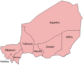
Regions of Niger
 |
|---|
| Judiciary |
Niger is divided into seven regions (French: régions; singular – région), each of which is named after its capital. Additionally, the national capital, Niamey, comprises a capital district.[1]
Current regions
| Region | Area (km2)[2] |
Population (2012 census) |
Population
(2020 estimate) |
|---|---|---|---|
| Agadez | 667,799 | 487,620 | 687,540 |
| Diffa | 156,906 | 593,821 | 837,290 |
| Dosso | 33,850 | 2,037,713 | 2,873,180 |
| Maradi | 41,796 | 3,402,094 | 4,796,950 |
| Niamey* | 402 | 1,026,848 | 1,447,860 |
| Tahoua | 113,371 | 3,328,365 | 4,692,990 |
| Tillabéri | 97,251 | 2,722,842 | 3,839,210 |
| Zinder | 155,778 | 3,539,764 | 4,991,070 |
*capital district.
Current administrative structure
Each of Niger's regions are subdivided into
Restructuring
Prior to the devolution program of 1999–2006, the regions were styled as departments. The current departments used to be called arrondissements.[5]]
1992 division
The department of Tillabéri was created in 1992, when Niamey Region (then called "department") was split, with the areas immediately outside Niamey renamed as the capital district.[6]
Historical evolution
Prior to independence, Niger was divided into sixteen cercles as second-level administrative divisions: Agadez, Birni N'Konni, Dogondoutchi, Dosso, Filingué, Gouré, Madaoua, Magaria, Maradi, N'Guigmi, Niamey, Tahoua, Téra, Tessaoua, Tillabéry, and Zinder. Their capitals had the same names as the cercle.
After independence, the 31 December 1961 Law of territorial organization created 31 circonscriptions. The 16 colonial cercles continued to exist, and served as a level of division above these circonscriptions. Four cercles (Dogondoutchi, Filingué, N'Guigmi, and Téra) had only one circonscription. The Law of August 14, 1964 then reorganized the country into seven departments, adopting the French second-level administration naming system, in contrast to neighbor Mali, which retained the colonial cercles and regions.
See also
- Departments of Niger
- Communes of Niger
- Geography of Niger
- ISO 3166-2:NE for the region codes under the ISO 3166-2 standard.
- List of FIPS region codes (M-O) for the department codes under the FIPS 10-4standard.
References
- ^ "Niger". The World Factbook. Central Intelligence Agency. 19 December 2023. Retrieved 30 December 2023.
- ^ Niger at GeoHive Archived 2015-04-20 at the Wayback Machine
- ^ Loi 2001-23, Article 6
- FAO.
- ^ *Mbaye Mbengue FAYE, Faria Ibrahim GESTION DES DECHETS ISSUS DES SOINS DE SANTE (DISS):RAPPORT PROVISOIRE, World Bank, Niamey, Décembre 2001.
- FONDS AFRICAIN DE DEVELOPPEMENT: ETUDE DE MOBILISATION DES EAUX DANS LA REGION DE MARADI NIGER[permanent dead link]. DEPARTEMENT AGRICULTURE ET DEVELOPPEMENT RURAL, OCAR. African Development Bank Group, MARCH 2003
- [http://www.ucdp.uu.se/gpdatabase/peace/nig19950415.pdf ACCORD ÉTABLISSANT UNE PAIX DÉFINITIVE ENTRE LE GOUVERNEMENT DE LA RÉPUBLIQUE DU NIGER ET L?ORGANISATION DE LA RÉSISTANCE ARMÉE (O. R. A.)
- ^ According to Statoids Archived 2009-07-24 at the Wayback Machine: "~1992: Tillabéry Region/department split from Niamey (whose FIPS code was NG05 before the change). Status of Niamey changed from department to capital district."