
Reichenbach Falls


The Reichenbach Falls (
In popular literature, Sir Arthur Conan Doyle gave the Grand (or Great) Reichenbach Fall as the location of the final physical altercation between his hero Sherlock Holmes and his greatest foe, the criminal Professor Moriarty, in "The Final Problem".
Location
The falls are located in the lower part of the Reichenbachtal, on the Rychenbach, a tributary (from the south bank) of the Aare. They are some 1.5 km (0.93 mi) south of the town of Meiringen, and {{Interlaken. Politically, the falls are within the municipality of Schattenhalb in the canton of Bern.[1][4]
The falls are made accessible by the
In popular culture
Arthur Conan Doyle's Sherlock Holmes stories
The town and the falls are known worldwide as the setting for a fictional event: it is the location where
Out of many
The actual ledge from which Moriarty fell is on the other side of the falls from the funicular; it is accessible by climbing the path to the top of the falls, crossing the bridge and following the trail down the hill. The ledge is marked by a plaque as illustrated here; the English inscription reads: "At this fearful place, Sherlock Holmes vanquished Professor Moriarty, on 4 May 1891." The pathway on which the duel between Sherlock Holmes and Professor Moriarty occurs ends some hundred metres away from the falls. When Doyle viewed the falls, the path ended very close to the falls, close enough to touch it, yet over the hundred years after his visit, the pathway has become unsafe and slowly eroded away, and the falls have receded further back into the gorge.[6]
In other media
The Reichenbach Falls are the subject of several early 19th-century paintings by the English Romantic landscape painter J. M. W. Turner.[7][8][9]
The indie band Ravens & Chimes named its debut album (released in 2007) after the falls.[10]
Reichenbach Falls was also the title of a 2008 BBC Four TV drama by James Mavor, based on an idea by Ian Rankin and set in Edinburgh. Numerous historical characters associated with the city, including Conan Doyle and his mentor Dr Joseph Bell, are mentioned in the story.[11]
Sherlock Holmes: A Game of Shadows, a 2011 film adaptation inspired by "The Final Problem", also hosts the falls, although in this adaptation, a large castle has been built over them, replacing the pathway.[12]
The third episode from the 2012 second series of the BBC drama Sherlock, "The Reichenbach Fall" (inspired by "The Final Problem"), is a play on the waterfall's name.[13][14] The special episode of Sherlock, "The Abominable Bride", which was broadcast on 1 January 2016, featured a re-creation of the showdown between Sherlock and Moriarty set in Victorian times, as depicted in the book.
The final season of the TV series Elementary features a villain named Odin Reichenbach. The next-to-last episode, in which the character meets justice, is titled "Reichenbach Falls".
-
 The Holmes plaque on the ledge
 -
 Holmes and Moriarty fighting at Reichenbach Falls, by Sidney Paget
 -
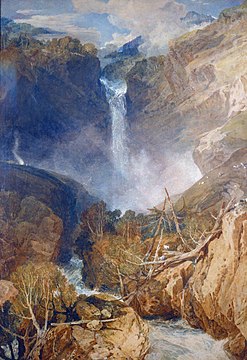 "The Great Fall of the Reichenbach, in the Valley of Hasle, Switzerland" (1804, watercolour on paper) byJ.M.W. Turner


References
- ^ ISBN 978-3-302-01210-0. Retrieved 2017-07-11 – via map.geo.admin.ch.
- ^ "Reichenbachfall". World Waterfall Database. Retrieved 18 November 2018.
- ^ Christian Schwick; Florian Spichtig (eds.). "Wasserfall-DB". waterfall.ch (in German). Zurich, Switzerland: Schweizerische Greina-Stiftung (SGS). Retrieved 2017-07-11.
- ^ a b c "Reichenbach Funicular". Grimselwelt. Innertkirchen, Switzerland: Kraftwerke Oberhasli AG. Retrieved 2017-07-11.
The thundering waters of the Reichenbach Waterfall
- ^ "Visit the Reichenbach Waterfalls near Meiringen in Switzerland". European Traveller. Retrieved 2012-01-16.
- ^ a b c "Peter Lunn". The Daily Telegraph. London. 6 December 2011. Retrieved 2011-12-15.
- ^ "The Great Fall of the Reichenbach, in the Valley of Hasle, Switzerland, 1804, Joseph Mallord William Turner". Tate, London. Retrieved 2013-01-06.
- ^ "The Great Fall of the Reichenbach, Switzerland, 1802, Joseph Mallord William Turner". Tate, London. Retrieved 2013-01-06.
- ^ "The Upper Falls of the Reichenbach, 1802, Joseph Mallord William Turner". Tate, London. Retrieved 2013-01-06.
- ^ Levack, Chandler (3 October 2007). "Ravens and Chimes". Spin. Retrieved 2013-01-06.
- Internet Movie Database. Retrieved 2013-01-06.
- ^ "Framestore - Sherlock Holmes: A Game of Shadows | AEAF News". Vfxfestival.com. Retrieved 2013-02-02.
- ^ Wollaston, Sam (15 January 2012). "TV review: Sherlock | Call the Midwife | Hugh's Hungry Boys". The Guardian. London. Retrieved 2012-01-16.
- ^ Crompton, Sarah (15 January 2012). "Sherlock: final episode, BBC One, review". The Daily Telegraph. London. Retrieved 2012-01-16.
External links
- Reichenbach Funiclar
- Photos from the Sherlock Holmes Society of London
- "Reichenbach Falls", BBC Four Film & Drama
| Novels |
|
|---|---|
| Story collections |
|
| Characters | |
| Uncollected stories |
|
| Universe | |
| Studies | |
| Related | |