Renfrewshire (historic)
| Renfrewshire | |
|---|---|
 Renfrewshire within Scotland | |
| Area | |
| • 1975 | 245 sq. miles (634 sq. km) (27th) |
| Population | |
| • 2014 est | 346,470 |
| • 1981 est | 366,509 |
| History | |
| • Origin | Strathclyde Region |
| Status | Local government county (until 1975) Lieutenancy area (1794-present) Land registration county (1996-present) |
| Chapman code | RFW |
| Government | County: Renfrewshire County Council (1890–1975) District: Eastwood District Council, Renfrew District Council, Inverclyde District Council (1975–1996) Modern: East Renfrewshire Council, Inverclyde Council, Renfrewshire Council (1996-present) Lieutenancy: Lord Lieutenant of Renfrewshire (1794-present) |
| • HQ | Renfrew (county town) Paisley (County Council headquarters) |
| • Motto | Avito viret honore ('Flourishing through ancestral honour')[1] |
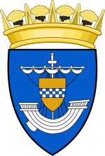
 Coat of arms of the county council | |
Renfrewshire or the County of Renfrew is a
The county borders Glasgow and Lanarkshire to the east and Ayrshire to the south and west. The Firth of Clyde forms its northern boundary, with Dunbartonshire and Argyll on the opposing banks.
Renfrewshire's early history is marked by
During the Industrial Revolution, many of the larger towns became important centres of commerce and manufacturing. The goods produced were chiefly cottons, calicos and silks building on the county's long weaving heritage. Other industries such as ship building, distilleries and printworks also contributed to the economy. Paisley grew to become the largest urban and commercial centre in the county by some margin. Renfrewshire County Council existed from 1890 until 1975, and was based in Paisley.
Parts of the county, such as Pollokshaws in 1912 and Nitshill in 1926, were incorporated into Glasgow during the early 20th century as the city expanded. Renfrewshire was abolished for local government purposes in 1975, being replaced by the Strathclyde region and three lower-tier district councils. These were in turn abolished in 1996, since when the Renfrewshire area has been governed by the three council areas of Renfrewshire, East Renfrewshire and Inverclyde.
History
Toponymy
The name of Renfrewshire derives from its county town,
The area is sometimes known as Greater Renfrewshire to distinguish it from the Renfrewshire council area.[4][5]
Early history


The earliest evidence of human activity in the area is traces of an
The principal Roman stronghold in the area was at Vanduara (Paisley). Following the end of Roman rule in Britain in 410, the Cumbrian Britons, with their capital at Dumbarton, retained a hold on all the territory west of the Lothian — the Kingdom of Strathclyde. During the High Middle Ages, Strathclyde was conquered by the Kingdom of Alba, which in turn developed into the Kingdom of Scotland.
In the 12th century, during the reign of
FitzAlan settled in the area and was granted the lands of
It is traditionally believed that Sir William Wallace, a knight and military leader during the period surrounding the Wars of Scottish Independence, was born in 1272 at Elderslie in the county.[10]
Emergence of the county
The descendants of Walter FitzAlan would eventually form the powerful House of Stuart, with 'Stuart' or 'Stewart' being a corruption of 'Steward'. The Stewarts controlled the territory that would later become Renfrewshire as a barony which lay within the larger shire of Lanarkshire.[11]
In 1371,
Modern history
Renfrewshire was significantly involved in the Radical War of 1820, with many of the local industrial workers participating in the rioting and strikes.
In the
The county was abolished for local government purposes in 1975, becoming three
Governance


Historic local government
Shires of Scotland traditionally mirrored
Historically Renfrewshire's

Elected county councils were established in 1890 under the
Further local government reform in 1930 under the Local Government (Scotland) Act 1929 brought Greenock, Paisley, and Port Glasgow under the control of the county council. During this time, several parts of eastern Renfrewshire were transferred into the growing city of Glasgow, including Cathcart, parts of Govan, and parts of the Parish of Renfrew lying north of the River Clyde (containing Yoker, Scotstoun and Jordanhill).[19][20]
Following the
Divisions
Before the creation of current single tier local authorities, there were typically a number of divisions within counties with varying levels of local government powers. Burghs generally covered urbanised areas with rural parts of a county divided into districts.
The Local Government (Scotland) Act 1947 defines the division of parts of the county which had pre-existed as:
- . These burghs continued to be responsible for most local services such as roads, water and housing.
- were responsible for services such as housing, parks and cleansing.
- Landward areas: all parts of the county that were not parts of a burgh, including the smaller settlements such as Bishopton and Clarkston. There were parish councils until 1930 when they were replaced by landward district councils with limited powers, such as over parks and recreation.
Aside from burghs and parishes, the county was subdivided between a number of higher tiers of local government during certain points in its history. Between the 1880s and the early 20th century, it is recorded that the county is divided between an 'Upper Ward' consisting of the eastern two-thirds of the county centred on Paisley, and a 'Lower Ward' approximating the boundaries of the modern Inverclyde council area and consisting of the parishes of Inverkip, Greenock, Port Glasgow and Kilmacolm, with Greenock as district centre.[22][23]
In 1973, prior to the abolition of the county council under the Local Government (Scotland) Act 1973, there were five districts in the landward areas of the county. The First District in the west formed part of Inverclyde District; the Second, Third and Fourth Districts in the geographical centre were grouped to form Renfrew District and the Fifth District in the east formed Eastwood District.[24]
County buildings
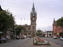
The County Council formerly met in the County Buildings, a
Modern functions
Lieutenancy
Whilst no longer used as a local authority area, Renfrewshire remains used for ceremonial purposes as a
The incumbent Lord Lieutenant of Renfrewshire since 2019 is Colonel Peter McCarthy. The Renfrewshire lieutenancy operates out of the headquarters of East Renfrewshire Council in Giffnock.[30]
Registration county
The County of Renfrew is a registration county used for land registration under the authority of the Land Registration (Scotland) Act 1979.[31] For this purpose, the county is defined as it existed in 1868 and so includes several areas subsequently annexed to Glasgow. The Renfrewshire registration county was the first to introduce the new Land Register of Scotland on the 6 April 1981.[31]
Other
For a number of purposes, the three modern local councils in the county co-operate on a number of matters. Renfrewshire is retained as a Joint Valuation Board area, which values properties for the purposes of
Central government bodies also use the historic boundaries of the area for some purposes. 'Scottish Enterprise Renfrewshire', a non-departmental public body accountable to the devolved Scottish Parliament which encourages enterprise and economic development, covers the three modern council areas in the county.[35]
Renfrewshire was officially a postal county used for administrative purposes by Royal Mail. Whilst this system has not been used for sorting mail since 1996, Royal Mail still keeps and distributes data relating to postal counties in the United Kingdom.
Parliamentary representation
Following the
Following the
The distribution of seats remained generally stable during Renfrewshire's time as an administrative county. In 1974, the constituency of Greenock was abolished and joined with Port Glasgow to create the constituency of Greenock and Port Glasgow.
With counties abolished for local government purposes, more wholesale reform of the constituency system in Scotland occurred in the 1980s, following the
Geography

Francis Hindes Groome's Ordnance Gazetteer for Scotland observes that the geography of the county can be seen as "falling into three divisions - hilly, gently rising, and flat". The higher areas are found to the south and west, particularly into the Renfrewshire Hills and to the border with Ayrshire, with large areas of moorland.
The land slopes downward to the
In the west of Renfrewshire can be found a number of small bodies of water such as
The upper scenery of the county was described in the 1911 Encyclopædia Britannica as "somewhat wild and bleak" though descending into pastureland around the rivers.[22] The north-east of the county is heavily urbanised and forms part of the Greater Glasgow conurbation.
The
Economy
Textiles


The traditional industries of Renfrewshire were noted for their variety and diversity.
Prior to the 19th century, weaving was largely a
Trade and shipbuilding
Greenock's ports remain active today with shipping from Ocean Terminal docks.
Modern industries
During the second half of the 20th century, some parts of the county experienced the effects of
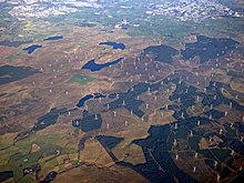
In the south-east of Renfrewshire on Eaglesham Moor can be found Whitelee Wind farm, the largest on-shore wind farm in the United Kingdom.
Culture
County symbols

The
Another symbol associated with the county is the Prince of Wales's feathers badge, demonstrating the heir to the throne's connections as Baron Renfrew. It was used historically on badges of local army and militia regiments, as well as the cap badges of the former Renfrewshire Constabulary.
The
In 2002, the charity Plantlife organised a UK-wide competition to categorise
There is a Renfrewshire tartan 'for use by anyone from or associated with the County of Renfrewshire' recorded on the official Scottish Register of Tartans.[39]
Sport
There are two professional association football teams in the county, Paisley's St Mirren F.C. and Greenock Morton F.C. Both compete within the Renfrewshire derby and annually for the Renfrewshire Cup. There are a number of rugby union clubs who participate in the Scottish West Regional League including Paisley RFC, Birkmyre RFC in Kilmacolm and Bishopton RFC .[40]
A number of local clubs participate in Western Division Cricket Union, including East Renfrewshire CC in Giffnock, Ferguslie CC in Paisley, Greenock CC, Inverclyde CC in Gourock, Kelburne CC in Paisley and Renfrew CC. The Paisley Pirates ice hockey team is based at Braehead Arena.
Renfrewshire houses five extant
Transport

The Inverclyde Line links Greenock to Glasgow by rail; a number of suburban train lines connect the areas of Glasgow that fall within Renfrewshire.
Ferries connect Gourock to
Glasgow Airport is situated in the county just to the north of Paisley, providing flights to a number of national and international destinations.[42]
Notable people
- Sir William Arrol - engineer
- John Galt - novelist
- David Stow - educationalist
- King House of Stewart
- Robert Tannahill - Paisley-based poet
- Sir William Wallace - military commander believed to have originated at Elderslie
- James Watt - engineer and steam-engine pioneer from Greenock
- Alexander Wilson - poet and naturalist
- John Witherspoon - clergyman, academic and a Founding Father of the United States of America
- John Maclean - born in Pollokshaws in 1879.
Settlements


In modern times, the chief settlements in Renfrewshire have been the towns of Paisley and Greenock and to this day they retain their status as the county's largest and second largest towns respectively. In the late 19th century, the county was subdivided into two wards centred on these towns, the Upper Ward (Paisley) and Lower Ward (Greenock).
These administrative separations are entirely extinct, with unitary councils in Renfrewshire's three modern council areas - Inverclyde (West), Renfrewshire (Central) and East Renfrewshire - holding full statutory powers of local government. Many of these settlements continue to be represented by community councils, sponsored by the local authority, albeit without any distinct powers.
List of settlements
The following is a list of present-day settlements that were part of historic Renfrewshire. Following boundary changes, a number fall outside of the three council areas and the registration county.
- Glasgow
- Anniesland (partly in Lanarkshire)
- Auldhouse
- Arden
- Cardonald
- Carnwadric
- Cathcart
- Corkerhill
- Crookston
- Crosshill
- Crossmyloof
- Darnley
- Deaconsbank
- Dumbreck
- Eastwood
- Hillington
- Househillwood
- Hurlet (part in East Renfrewshire)
- Jenny Lind
- Jordanhill
- Kennishead
- Kingston
- Knightswood (partly in Dunbartonshire)
- Langside
- Mansewood
- Merrylee
- Mosspark
- Mount Florida
- Muirend (part in East Renfrewshire)
- Newlands
- Nitshill
- Oatlands (partly in Lanarkshire)
- Parkhouse
- Penilee
- Pollok
- Pollokshaws
- Pollokshields
- Polmadie
- Roughmussel
- Scotstoun
- Shawlands
- Simshill
- South Nitshill
- Southpark Village
- Strathbungo
- Yoker
- East Renfrewshire
- Barrhead
- Busby (partly in Lanarkshire)
- Clarkston
- Eaglesham
- Giffnock
- Hurlet (part in Glasgow)
- Muirend (mostly in Glasgow)
- Neilston
- Netherlee
- Newton Mearns
- Uplawmoor
- Waterfoot
- Renfrewshire
- Bishopton
- Bridge of Weir
- Clippens(no longer exists)
- Crosslee
- Elderslie
- Erskine
- Houston
- Howwood
- Inchinnan
- Inkerman (no longer exists)
- Johnstone
- Kilbarchan
- Linwood
- Lochwinnoch
- Milliken Park
- Paisley
- Ranfurly
- Renfrew
- Inverclyde
- Bogston
- Greenock
- Gourock
- Inverkip
- Kilmacolm
- Langbank
- Mid Auchinleck
- Port Glasgow
- Quarrier's Village
- Wemyss Bay
- Woodhall
See also
References
- ^ A.C. Fox-Davies, Public Arms of the United Kingdom of Great Britain and Ireland (1915)
- ^ Charnock, Richard Stephen (1859). "Local Etymology: A Derivative Dictionary of Geographical Names". R.S. Charnock, London, 1859.
- ^ "Scran ::: PRAEFECTURA RENFROANA Vulgo dicta BARONIA". Scran.
- ^ "Sorry, the page you're looking for is not available. - E..." www.eastrenfrewshire.gov.uk. Retrieved 21 August 2018.
- ^ "Progress Report" (PDF).
- Edinburgh UniversityPress, 1954, p.281
- ^ Anderson (1867) vol.ix, p.512
- ISBN 0-19-822473-7page 64-5, where it is stated that Walter son of Alan came to Scotland about 1136 and served as "dapifer" or Steward successively to kings David I, Malcolm IV, and William the Lion.
- Edinburgh UniversityPress, 1954, [p.280
- ^ ^ Watson, "Sir William Wallace", p. 27; Grant, "Bravehearts and Coronets", pp. 90–91.
- ^ Chalmers, George (1890). Caledonia. London: T. Cadell. p. 771. Retrieved 29 January 2023.
- ^ Metcalfe, William Musham (1905). A history of the county of Renfrew from the earliest times. Paisley: A. Gardner. p. 77. Retrieved 29 January 2023.
- ^ Galland, Adolf (1954). The First and the Last: The Rise and Fall of the German Fighter Forces, 1938-1945 (1968 Ninth Printing - paperbound ed.). New York: Ballantine Books. p. 56.
- ^ Shirer, William L. The Rise and Fall of the Third Reich.
- ^ "Act of the convention of estates of the kingdome of Scotland etc. for ane new and voluntar offer to his majestie of seventie two thousand pounds monethlie for the space of twelve moneths", Records of the Parliaments of Scotland, 23 January 1667
- ^ Chisholm, Hugh, ed. (1911). . Encyclopædia Britannica. Vol. 24 (11th ed.). Cambridge University Press. pp. 848–850.
- ^ "County Council". Paisley and Renfrewshire Gazette. Paisley. 24 May 1890. p. 5. Retrieved 30 January 2023.
- ^ "LOCAL GOVERNMENT FOR SCOTLAND. (Hansard, 8 April 1889)". api.parliament.uk.
- ^ "Govan". Gazetteer for Scotland.
- ^ "Parish of Renfrew". Gazetteer for Scotland.
- ^ "Local Government etc. (Scotland) Act 1994", legislation.gov.uk, The National Archives, 1994 c. 39, retrieved 30 January 2023
- ^ a b Chisholm, Hugh, ed. (1911). . Encyclopædia Britannica. Vol. 23 (11th ed.). Cambridge University Press. pp. 98–99.
- ^ a b c d e f "Old County of Renfrewshire".
- ^ Part III, Schedule 1, Local Government (Scotland) Act 1973
- ^ "County Square". Renfrewshire Council.
- ^ "Doors Open Days Scotland 2018 - Get into buildings!". Doors Open Day. Retrieved 21 August 2018.
- ^ "Paisley Sculptures" (PDF). Renfrewshire Council.
- ^ Historic Environment Scotland. "Paisley Sheriff Court (LB39103)". Retrieved 18 July 2021.
- ^ "The Lord-Lieutenants Order 1975", legislation.gov.uk, The National Archives, SI 1975/428, retrieved 30 January 2023
- ^ "Lord-Lieutenants of Scotland". Retrieved 21 August 2018.
- ^ a b "Archived copy" (PDF). Archived from the original (PDF) on 28 September 2013. Retrieved 26 September 2013.
{{cite web}}: CS1 maint: archived copy as title (link) - ^ "Home".
- ^ "Renfrewshire Educational Trust".
- ^ "Civil contingencies". Renfrewshire Council.
- ^ "iBooked.co.uk - Top cultural European holiday destinations". iBooked.co.uk.
- ^ "Coats Viyella". Archiveshub.ac.uk. Archived from the original on 19 July 2012.
- ^ R M Urquhart, Scottish Civic Heraldry (Scottish Library Association, Hamilton, 2001)
- ^ "Court of the Lord Lyon" (PDF).
- ^ Scotland, National Records of. "Tartan Details - The Scottish Register of Tartans". www.tartanregister.gov.uk. Retrieved 21 August 2018.
- ^ "Renfrewshire Tournament".
- ^ "Fields in Trust" (PDF).
- ^ glasgowairport.com - Route Map retrieved 15 February 2017
- ^ Descriptive Gazetteer Entry for Renfrewshire A vision of Britain through time
