
Resolution Guyot
21°15′0″N 174°20′0″E / 21.25000°N 174.33333°E


Resolution Guyot (formerly known as Huevo) is a guyot (tablemount) in the underwater Mid-Pacific Mountains in the Pacific Ocean. It is a circular flat mountain, rising 500 metres (1,600 ft) above the seafloor to a depth of about 1,320 metres (4,330 ft), with a 35-kilometre-wide (22 mi) summit platform. The Mid-Pacific Mountains lie west of Hawaii and northeast of the Marshall Islands, but at the time of its formation, the guyot was located in the Southern Hemisphere.
The guyot was probably formed by a hotspot in today's French Polynesia before plate tectonics shifted it to its present-day location. The Easter, Marquesas, Pitcairn and Society hotspots, among others, may have been involved in the formation of Resolution Guyot. Volcanic activity has been dated to have occurred 107–129 million years ago and formed a volcanic island that was subsequently flattened by erosion. Carbonate deposition commenced, forming an atoll-like structure and a carbonate platform.
The platform emerged above sea level at some time between the
Name and research history
Resolution Guyot was informally known as Huevo Guyot
Geography and geology
Local setting
Resolution Guyot is one of the western Mid-Pacific Mountains, located west of Hawaii, north-northeast of the Marshall Islands.[7] Unlike conventional Pacific Ocean island chains,[8] the Mid-Pacific Mountains are a group of oceanic plateaus with guyots[9] (also known as tablemounts)[10]) that become progressively younger towards the east.[11] Other guyots in the Mid-Pacific Mountains are Sio South, Darwin, Thomas, Heezen, Allen, Caprina, Jacqueline and Allison.[12]
The seamount is about 500 metres (1,600 ft) high and rises from a raised seafloor
The guyot rises from a seafloor of Jurassic age[11] (201.3 ± 0.2 – ca. 145 million years ago[21]) that might be as much as 154 million years old.[9] Terrestrial organic material on the seafloor around Resolution Guyot originated from when it was still an island,[22] and carbonate sediments swept away from the guyot collected on the surrounding seafloor.[23][24]
Regional setting
-1.svg)
The
The formation of many seamounts has been explained by the
Composition
Rocks found at Resolution Guyot include
The carbonates occur in the form of
Organic materials[e] found in rock samples from Resolution Guyot[56] appear to be mainly of marine origin.[58] Some of the organic matter comes from microbial mats and vegetated islands,[59] including wood[60] and plant remains.[14]
Clays found on Resolution Guyot are characterized as
Geologic history
Cretaceous graphical timeline | ||||
−140 — – −130 — – −120 — – −110 — – −100 — – −90 — – −80 — – −70 — – |
| |||
Although
Volcanic phase
Eruptions in the area built a pile of volcanic rocks, including stacks of
Platform carbonates and reefs
Between the Hauterivian (ca. 132.9 – ca. 129.4 million years ago[21]) and Albian (ca. 113 – 100.5 million years ago[21]), about 1,619 metres (5,312 ft) of carbonate was deposited on the volcanic structure,[47] eventually completely burying it during the Albian.[74] About 14 individual sequences of carbonates have been identified in drill cores.[75] The carbonate sedimentation probably began in the form of shoals surrounding a volcanic island[76] and lasted for about 35 million years,[77] accompanied by perhaps 0.046 millimetres per year (0.0018 in/year) of subsidence.[78] It is likely that the present-day carbonate platform contains only a fraction of the originally deposited carbonate, most of the carbonate having disappeared.[79] During this time, Resolution Guyot underwent little latitudinal plate motion; from the magnetization it appears that it was stably located at about 13° southern latitude between the Hauterivian and Aptian.[80]
Its carbonate platform cannot be reconstructed as only small parts have been studied, but some conclusions can be made.
The Cretaceous Apulian Carbonate Platform in Italy and the Urgonian Formation in France have been compared to the Resolution Guyot carbonates. All these platforms were located in Tethyan seas[87] and several formations in these three carbonate environments are correlated;[88] for example, the fauna identified on Resolution Guyot resembles that from other Northern Hemisphere platforms.[89] Analogies also exist to platforms in Venezuela.[88]
- Present-day environments that resemble those of the former environments of Resolution Guyot
-
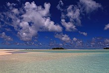 A beach and shallow water, Cook Islands
 -
 Spaceborne image of mudflats and tidal channels on present-day Long Island, Bahamas; the former morphology of Resolution Guyot has been compared to that of the present-day Bahamas.
 -
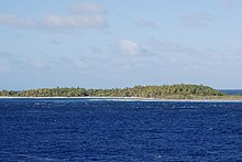 Vegetated island on Suwarrow
.jpg)


Water temperatures in the early
Through the history of the platform
Life on Resolution Guyot included
Uplift and karstification
During the Albian to Turonian (93.9 – 89.8 ± 0.3 million years ago[21]),[108] the carbonate platform rose above the sea by about 100 metres (330 ft)[109]–160 metres (520 ft). This uplift episode at Resolution Guyot is part of an episode of more general tectonic changes in the Pacific Ocean, with a general uplift of the ocean floor and tectonic stress changes at the ocean margins. This tectonic event has been explained by a major change in mantle convection in the middle Cretaceous pushing the ocean floor upward and sideward.[110]
When Resolution Guyot rose above sea level,
Drowning and post-drowning evolution
Resolution Guyot drowned either about 99 ± 2 million years ago[118] or during the Maastrichtian (72.1 ± 0.2 to 66 million years ago[21]),[47] although a hiatus in shallow carbonate deposition appears to date back to the Albian[112][119] that may reflect a long pause in deposition or increased erosion.[112] The end Albian period was characterized by widespread cessation of carbonate sedimentation across the western Pacific.[120][108] It is possible that carbonate sedimentation later continued until Campanian (83.6 ± 0.2 – 72.1 ± 0.2 million years ago[21])-Maastrichtian times.[71] The platform was certainly submerged by Pliocene (5.333 – 2.58 million years ago[21]) times.[11]
Other carbonate platforms in the Pacific drowned especially at the end of the Albian,
After the drowning, crusts formed by ferromanganese and by phosphate-modified rocks developed on exposed surfaces at Resolution Guyot.[20] Several different layers of phosphate modification have been observed during the Albian alone[119] and this process may have begun when the platform was still active; water within the rocks may have triggered phosphatization at this stage.[126] The ferromanganese deposition probably only began in the Turonian-Maastrichtian,[71] when the seamount had subsided to a sufficient depth.[127] Manganese-encrusted Cretaceous limestones have been found within the pelagic sediments.[128]
As at other guyots in the Pacific Ocean
Carbonates were dissolved and replaced by dolomite already during the Aptian and Albian. Around 24 million years ago at the Paleogene-Neogene (23.02 – 2.58 million years ago[21]) boundary, a second pulse of dolomite formation took place; perhaps sea level changes associated with global climate change triggered this second pulse.[97] The formation of the dolomites was probably aided by the fact that seawater can percolate through Resolution Guyot,[48] which may be responsible for the formation of fluid vent structures on the surface of the seamount.[132]
Notes
- drill cores from the oceans.[4]
- ^ Pit-like depressions within carbonate rocks that are filled with water.[32]
- ^ Cementation is a process during which grains in rock are solidified and pores filled by the deposition of minerals such as calcium carbonate.[54]
- ^ Volcanic rocks that appear as fragments.[69]
- ^ A makatea is a raised coral reef on an island, such as on Atiu, Mangaia, Mauke and Mitiaro in the Cook Islands.[115]
References
- ^ a b c d e f Baker, Castillo & Condliffe 1995, p. 246.
- ^ a b c d e f Winterer & Sager 1995, p. 501.
- ^ "IHO-IOC GEBCO Gazetteer of Undersea Feature Names". www.gebco.net. Retrieved 2 October 2018.
- ^ "Ocean Drilling Program". Texas A&M University. Retrieved 8 July 2018.
- ^ Firth 1993, p. 1.
- ^ a b c Firth 1993, p. 2.
- ^ Arnaud, Flood & Strasser 1995, p. 134.
- ^ a b c Winterer & Sager 1995, p. 508.
- ^ a b c Baker, Castillo & Condliffe 1995, p. 245.
- S2CID 128836166.
- ^ a b c d e Röhl & Strasser 1995, p. 198.
- ^ a b McNutt et al. 1990, p. 1101.
- ^ McNutt et al. 1990, p. 1102.
- ^ a b c d e Iryu & Yamada 1999, p. 478.
- ^ El-Yamani, John & Bell 2022, p. 1539.
- ^ a b Winterer & Sager 1995, p. 504.
- ^ a b Winterer 1998, p. 60.
- ^ a b c d Winterer 1998, p. 61.
- ^ a b Murdmaa et al. 1995, p. 420.
- ^ a b Murdmaa et al. 1995, p. 419.
- ^ a b c d e f g h i j k l m n "International Chronostratigraphic Chart" (PDF). International Commission on Stratigraphy. August 2018. Archived from the original (PDF) on 31 July 2018. Retrieved 22 October 2018.
- ^ Baudin et al. 1995, p. 192.
- ^ Jenkyns & Strasser 1995, p. 117.
- ^ Sliter 1995, p. 21.
- ^ van Waasbergen 1995, p. 471.
- ^ Iryu & Yamada 1999, p. 485.
- ^ Röhl & Strasser 1995, p. 211.
- ^ Pringle et al. 1993, p. 359.
- ^ Röhl & Ogg 1996, p. 596.
- ^ Röhl & Ogg 1996, pp. 595–596.
- ^ Strasser et al. 1995, p. 119.
- S2CID 140604929.
- ^ Pringle et al. 1993, p. 360.
- ^ Winterer & Sager 1995, p. 498.
- .
- S2CID 4325917.
- ^ Baker, Castillo & Condliffe 1995, p. 255.
- ^ a b Baudin et al. 1995, p. 173.
- ^ a b Baker, Castillo & Condliffe 1995, pp. 246–247.
- ^ Kurnosov et al. 1995, pp. 478, 484.
- ^ Kurnosov et al. 1995, p. 477.
- ^ Kurnosov et al. 1995, p. 476.
- ^ Kurnosov et al. 1995, p. 478.
- ^ Iryu & Yamada 1999, p. 482.
- ^ a b c d e Arnaud, Flood & Strasser 1995, p. 137.
- ^ Swinburne & Masse 1995, p. 4.
- ^ a b c d e Arnaud, Flood & Strasser 1995, p. 133.
- ^ a b c Röhl & Strasser 1995, p. 199.
- ^ Arnaud, Flood & Strasser 1995, pp. 133, 137.
- ^ a b c Röhl & Strasser 1995, p. 201.
- ^ Flood & Chivas 1995, p. 161.
- ^ a b c d Arnaud, Flood & Strasser 1995, p. 136.
- ^ a b Murdmaa & Kurnosov 1995, p. 459.
- )
- ^ Grötsch & Flügel 1992, p. 168.
- ^ a b c Baudin et al. 1995, p. 184.
- ^ Baudin et al. 1995, p. 174.
- ^ Baudin et al. 1995, p. 189.
- ^ Baudin et al. 1995, p. 193.
- ^ a b Strasser et al. 1995, p. 120.
- ^ Murdmaa & Kurnosov 1995, p. 462.
- ^ a b c Baudin et al. 1995, p. 179.
- ^ Winterer & Sager 1995, p. 514.
- ^ Murdmaa et al. 1995, p. 421.
- ^ a b c d e Arnaud, Flood & Strasser 1995, p. 140.
- ^ a b Arnaud, Flood & Strasser 1995, p. 150.
- ^ International Commission on Stratigraphy. "ICS - Chart/Time Scale". www.stratigraphy.org.
- .
- ISSN 0016-7606.
- ^ Winterer & Sager 1995, p. 503.
- ^ S2CID 133112023.
- ^ Kurnosov et al. 1995, p. 475.
- ^ El-Yamani, John & Bell 2022, p. 1556.
- ^ a b Murdmaa & Kurnosov 1995, p. 466.
- ^ Röhl & Ogg 1996, p. 599.
- ^ Arnaud, Flood & Strasser 1995, p. 141.
- ^ a b Arnaud, Flood & Strasser 1995, p. 154.
- ^ a b c d Strasser et al. 1995, p. 126.
- ^ Winterer & Sager 1995, p. 512.
- .
- ^ Röhl & Strasser 1995, p. 223.
- ^ Swinburne & Masse 1995, p. 9.
- ^ a b van Waasbergen 1995, p. 482.
- ^ Arnaud, Flood & Strasser 1995, pp. 138, 140.
- ^ a b c d Arnaud, Flood & Strasser 1995, p. 148.
- ^ a b Jenkyns & Strasser 1995, p. 116.
- ^ Arnaud, Flood & Strasser 1995, p. 151.
- ^ a b Arnaud, Flood & Strasser 1995, p. 153.
- ^ Swinburne & Masse 1995, p. 8.
- ISSN 0146-6380.
- ^ Winterer & Sager 1995, p. 509.
- ^ a b Strasser et al. 1995, p. 125.
- ^ Röhl & Ogg 1996, p. 597.
- ^ Baudin et al. 1995, pp. 192–193.
- .
- ^ Wilson et al. 1998, p. 893.
- ^ a b Flood & Chivas 1995, p. 163.
- ^ El-Yamani, John & Bell 2022, p. 1540.
- ^ Skelton, Sano & Masse 2013, p. 513.
- ^ Arnaud, Flood & Strasser 1995, pp. 133–134.
- ^ Swinburne & Masse 1995, p. 5.
- ^ Swinburne & Masse 1995, p. 14.
- ^ Swinburne & Masse 1995, p. 7.
- ^ Skelton, Sano & Masse 2013, p. 515.
- ^ Skelton, Sano & Masse 2013, p. 514.
- ^ Arnaud, Flood & Strasser 1995, p. 135.
- ^ Arnaud, Flood & Strasser 1995, p. 139.
- ^ a b Winterer & Sager 1995, p. 525.
- ^ a b Winterer & Sager 1995, p. 523.
- .
- ^ Winterer 1998, p. 59.
- ^ a b c Sliter 1995, p. 20.
- ^ a b El-Yamani, John & Bell 2022, p. 1543.
- ^ a b Winterer & Sager 1995, p. 532.
- .
- ^ Grötsch & Flügel 1992, p. 172.
- ^ Röhl & Strasser 1995, p. 210.
- ^ Wilson et al. 1998, p. 892.
- ^ a b Murdmaa et al. 1995, p. 422.
- ^ Sliter 1995, p. 23.
- ^ Röhl & Ogg 1996, p. 595.
- ^ Winterer & Sager 1995, p. 500.
- ^ Firth 1993, p. 4.
- ^ Sliter 1995, p. 25.
- ^ Wilson et al. 1998, pp. 892–893.
- ^ Murdmaa et al. 1995, p. 423.
- ^ Murdmaa et al. 1995, p. 424.
- ^ Sliter 1995, p. 15.
- ^ Watkins et al. 1995, p. 675.
- ^ Watkins et al. 1995, p. 684.
- S2CID 24261323.
- ^ El-Yamani, John & Bell 2022, p. 1560.
Sources
- Arnaud, H.M.; Flood, P.G.; Strasser, A. (May 1995). "Resolution Guyot (Hole 866A, Mid-Pacific Mountains): Facies Evolution and Sequence Stratigraphy" (PDF). Proceedings of the Ocean Drilling Program, 143 Scientific Results. Vol. 143. Ocean Drilling Program. . Retrieved 30 September 2018.
- Baker, P.E.; Castillo, P.R.; Condliffe, E. (May 1995). "Petrology and Geochemistry of Igneous Rocks from Allison and Resolution Guyots, Sites 865 and 866" (PDF). Proceedings of the Ocean Drilling Program, 143 Scientific Results. Vol. 143. Ocean Drilling Program. . Retrieved 30 September 2018.
- Baudin, F.; Deconinck, J.-F.; Sachsenhofer, R.F.; Strasser, A.; Arnaud, H. (May 1995). "Organic Geochemistry and Clay Mineralogy of Lower Cretaceous Sediments from Allison and Resolution Guyots (Sites 865 and 866), Mid-Pacific Mountains" (PDF). Proceedings of the Ocean Drilling Program, 143 Scientific Results. Vol. 143. Ocean Drilling Program. . Retrieved 30 September 2018.
- El-Yamani, Mahmoud S.; John, Cédric M.; Bell, Rebecca (15 September 2022). "Stratigraphic evolution and karstification of a Cretaceous Mid-Pacific atoll (Resolution Guyot) resolved from core-log-seismic integration and comparison with modern and ancient analogues". Basin Research. 34 (5): 1536–1566. S2CID 248223664.
- Firth, John (27 April 1993). "Examining Guyots in the Mid-Pacific Mountains". Eos, Transactions American Geophysical Union. 74 (17): 201–206. ISSN 0096-3941.
- Flood, P.G.; Chivas, A.R. (May 1995). "Origin of Massive Dolomite, Leg 143, Hole 866A, Resolution Guyot, Mid-Pacific Mountains" (PDF). Proceedings of the Ocean Drilling Program, 143 Scientific Results. Vol. 143. Ocean Drilling Program. . Retrieved 30 September 2018.
- Grötsch, Jürgen; Flügel, Erik (December 1992). "Facies of sunken early cretaceous atoll reefs and their capping Late Albian drowning succession (Northwestern Pacific)". Facies. 27 (1): 153–174. S2CID 128544669.
- Iryu, Yasufumi; Yamada, Tsutomu (December 1999). "Biogeochemical contrasts between mid-Cretaceous carbonate platforms and Cenozoic reefs". The Island Arc. 8 (4): 475–490. S2CID 128968750.
- Jenkyns, H.C.; Strasser, A. (May 1995). "Lower Cretaceous Oolites from the Mid-Pacific Mountains (Resolution Guyot, Site 866)" (PDF). Proceedings of the Ocean Drilling Program, 143 Scientific Results. Vol. 143. Ocean Drilling Program. . Retrieved 30 September 2018.
- Kurnosov, V.; Zolotarev, B.; Eroshchev-Shak, V.; Artamonov, A.; Kashinzev, Murdmaa (December 1995). "Alteration of Basalts from the West Pacific Guyots, Legs 143 and 144" (PDF). Proceedings of the Ocean Drilling Program, 144 Scientific Results. Vol. 144. Ocean Drilling Program. . Retrieved 30 September 2018.
- McNutt, M. K.; Winterer, E. L.; Sager, W. W.; Natland, J. H.; Ito, G. (July 1990). "The Darwin Rise: A Cretaceous superswell?". Geophysical Research Letters. 17 (8): 1101–1104. S2CID 51837887.
- Murdmaa, I.; Nemliher, J.; Bogdanova, O.; Gorshkov, A.; Kallaste, T.; Vasilyeva, V. (December 1995). "Ferromanganese and Phosphatic Hardgrounds on the Western Pacific Guyots Drilled during Legs 143 and 144" (PDF). Proceedings of the Ocean Drilling Program, 144 Scientific Results. Vol. 144. Ocean Drilling Program. . Retrieved 30 September 2018.
- Murdmaa, I.; Kurnosov, V.and Vasilyeva (December 1995). "Clay Mineralogy of the Shallow-Water Deposits on Allison and Resolution Guyots, Sites 865 and 866" (PDF). Proceedings of the Ocean Drilling Program, 144 Scientific Results. Vol. 144. Ocean Drilling Program. . Retrieved 30 September 2018.
- Pringle, Malcolm S.; Sager, William W.; Sliter, William V.; Stein, Seth, eds. (1993). The Mesozoic Pacific: Geology, Tectonics, and Volcanism: A Volume in Memory of Sy Schlanger. Geophysical Monograph Series. Vol. 77. ISSN 0065-8448.
- Röhl, Ursula; Ogg, James G. (October 1996). "Aptian-Albian sea level history from Guyots in the western Pacific". Paleoceanography. 11 (5): 595–624. ISSN 0883-8305.
- Röhl, U.; Strasser, A. (May 1995). "Diagenetic Alterations and Geochemical Trends in Early Cretaceous Shallow-Water Limestones of Allison and Resolution Guyots (Sites 865 to 868)" (PDF). Proceedings of the Ocean Drilling Program, 143 Scientific Results. Vol. 143. Ocean Drilling Program. . Retrieved 30 September 2018.
- Skelton, Peter W.; Sano, Shin-Ichi; Masse, Jean-Pierre (1 January 2013). "Rudist bivalves and the Pacific in the Late Jurassic and Early Cretaceous". Journal of the Geological Society. 170 (3): 2012–2017. S2CID 128739401.
- Sliter, W.V. (May 1995). "Cretaceous Planktonic Foraminifers from Sites 865, 866, and 869: A Synthesis of Cretaceous Pelagic Sedimentation in the Central Pacific Ocean Basin" (PDF). Proceedings of the Ocean Drilling Program, 143 Scientific Results. Vol. 143. Ocean Drilling Program. . Retrieved 30 September 2018.
- Strasser, A.; Arnaud, H.; Baudin, F.; Rohl, U. (May 1995). "Small-Scale Shallow-Water Carbonate Sequences of Resolution Guyot (Sites 866, 867, and 868)" (PDF). Proceedings of the Ocean Drilling Program, 143 Scientific Results. Vol. 143. Ocean Drilling Program. . Retrieved 30 September 2018.
- Swinburne, N.H.M.; Masse, J.-P. (May 1995). "Early Cretaceous Rudist Fauna of Allison and Resolution Guyots, Mid-Pacific Mountains" (PDF). Proceedings of the Ocean Drilling Program, 143 Scientific Results. Vol. 143. Ocean Drilling Program. . Retrieved 30 September 2018.
- van Waasbergen, R.J. (May 1995). "Sediment Facies and Environments of Deposition on Cretaceous Pacific Carbonate Platforms: An Overview of Dredged Rocks from Western Pacific Guyots" (PDF). Proceedings of the Ocean Drilling Program, 143 Scientific Results. Vol. 143. Ocean Drilling Program. . Retrieved 30 September 2018.
- Watkins, D.K.; Pearson, P.N.; Erba, E.; Rack, F.R.; Premoli Silva, I.; Bohrmann, H.W.; Fenner, J.; Hobbs, P.R.N. (December 1995). "Stratigraphy and Sediment Accumulation Patterns of the Upper Cenozoic Pelagic Carbonate Caps of Guyots in the Northwestern Pacific Ocean" (PDF). Proceedings of the Ocean Drilling Program, 144 Scientific Results. Vol. 144. Ocean Drilling Program. . Retrieved 30 September 2018.
- Wilson, Paul A.; Jenkyns, Hugh C.; Elderfield, Henry; Larson, Roger L. (April 1998). "The paradox of drowned carbonate platforms and the origin of Cretaceous Pacific guyots". Nature. 392 (6679): 889–894. S2CID 4423865.
- Winterer, Edward L. (1998). "Cretaceous karst guyots: New evidence for inheritance of atoll morphology from subaerial erosional terrain". Geology. 26 (1): 59. ISSN 0091-7613.
- Winterer, E.L.; Sager, W.W. (May 1995). "Synthesis of Drilling Results from the Mid-Pacific Mountains: Regional Context and Implications" (PDF). Proceedings of the Ocean Drilling Program, 143 Scientific Results. Vol. 143. Ocean Drilling Program. . Retrieved 30 September 2018.