
Ray, Iran
This article may require copy editing for grammar, style, cohesion, tone, or spelling. (April 2023) |
Shahr-e Rey
ری | |
|---|---|
District of Tehran | |
.jpg) .jpg)     From top; left to right: IRDT) | |
| Area code | 021 |
Shahre Ray, Shahr-e Ray, Shahre Rey, or Shahr-e Rey (
Historically known as Rhages (
Ray has been home to many historical figures, including royalty, merchants, scholars and poets. The medieval Persian scholar
Ray today has many industries and factories in operation. It is connected via the rapid transit system of Tehran Metro to the rest of Greater Tehran.
Geography
Mountain ranges
Ray County is located in the plain and its mountains are not very tall. These mountains are:
1. Bibi Sharbanu (کوه بی بی شهر بانو): Bibi Sharbanu Mountains are located in the east of Ray City, measuring 1535 meters above sea level.[5]
2. Arad mauntain (کوه آراد): located in the center of Ray County, on the border between Kahrizak and Fashapoye parts, its height is 1428 meters.[6] This range also appears in a map dated to 1307 AH, during the era of Naser al-Din Shah Qajar, drawn by two Iranian engineers of the time. In the book Detailed Geography of Iran, Mount Arad is mentioned with the name of mountains Hasanabad and Kanargard (حسنآباد and کنارگرد).
3. Mar_e (mære): located in the southwest of Ray City and in the south of the cities of Hassanabad and Rudshur. Its height is 1503 meters.[7]
4. Kūh-e Qarah Bologh (کوه کورابلاغ): This mountain is located at the intersection of four cities, Zarandiyeh, Saveh, Ray and Qom.[8]

Rivers

1. Karaj River: The Karaj River originates from Mount Alborz and flows into the Salt Lake after passing through several cities in Tehran Province. This river runs in a northwest-southeast direction throughout Ray City and after joining one of the branches of Jajroud flows into the salt lake.[9] It is the second largest river after Zayandarud in the central plateau region.[9]
2. Jajrud river: Jajroud river is one of the permanent and important rivers of Tehran province, which flows along the southern direction and finally into the salt lake. A branch of this river passes through the eastern border of Ray City.[citation needed]
3. Shur Fashapoye River: The Shore River originates from Zanjan province and after passing through Qazvin province, the southwest of Tehran province and Zarandieh city, it reaches Ray City. This river crosses the width of Ray city in a northwest-southeast direction. The river is permanent and is 420 kilometers long.
Vegetation
The climate of the city is semi-desert and it does not have natural forest, and its hand-planted forest is 387 hectares. But in terms of pasture, it is relatively rich and has 166,200 hectares of pasture.
Name
Shahr-e Rey (شَهرِ رِی, Šahr-e Rey) is Persian for "City of Ray". Ray or Rey (رِی) derives from Old Persian Ragā (𐎼𐎥𐎠), related to Persian رَخش rakhsh (red). It is recorded in Ancient Greek as Rhágai (Ῥάγαι) and Rháges (Ῥάγες) and in Latin as Rhagae and Rhaganae. It was once renamed Europos (Ευρωπός) under the Seleucid Empire.
The name is spelled in various forms, including Ray, Rey, Rayy and Rhay. Encyclopædia Iranica uses Ray.[10]
In the past, the people of Ray were called "Razi".
History
Agricultural settlements were long established as part of the Central Plateau Culture on local foothills such as that of Cheshme-Ali in northern Ray, which dates back to around 6,000 BC.[11] The establishment of Ray has been attributed to ancient mythological monarchs, and it is also believed that Ray was the seat of a dynasty of Zoroastrian leadership.
Classical era
The
Ray was one of the main strongholds of the
Under the
Middle Ages
Siyavash, the son of Mehran and the last King of Ray in the Sasanian Empire, was defeated fighting the Muslim invasion in 643.[20] Ray was then used as a camp site under Arab military occupation.[10] By the time of the Abbasid Caliphate, Ray was considerably restored and expanded into a new city named Mohammadiya.[10] During the early Islamic period, the language spoken in Ray was the Razi dialect, which was most likely a continuation of the Median language.[12]
The
A Tower of Silence, where Zoroastrians of after the Muslim conquest had come to put the bodies of the dead in the open, was built by a wealthy inhabitant of Ray on a hill in the tenth century. The tower, today in ruins and designated as Gabri (a term denoting "Zoroastrian", adopted after the Muslim conquest), was reportedly soon taken by the Muslims.[23][24]
Also dating to the tenth century is the
Ray was one of the capital cities of the Buyid dynasty.[26] It was one of the cities that were equipped with rapid postal service, which was predominantly used for transferring official mails.[27]
Ray was also a capital city of the
Ray was home to a Shia Muslim community and some of the earliest Shia madrasas in Iran already in the 12th century, at least one established by Shia scholar Qazvini Razi, prior to the later Safavid official adoption of Shiism as the state religion.[30]
In the early 13th century, following the
Early modern times
Amin Razi, a Persian geographer from Ray who lived by the time of the Safavid dynasty, attests to the "incomparable abundance" of the gardens and canals of his hometown. In 1618, Italian author Pietro Della Valle described Ray as a large city with large gardens that was administered by a provincial governor but was not urbanized and didn't seem to be inhabited.[11]
The shrines of Shah Abdol-Azim and Bibi Shahrbanu, among other religious shrines throughout Iran, were notably reconstructed during the early modern period, using architectural techniques that were developed since the time of the Safavid dynasty to the time of the Qajar dynasty.[31][32][25]
There is
Contemporary era

In the middle of the 19th century, Ray was described as a place of ruins, the only settlement being around the Shah Abdol-Azim Shrine.[33] Being the only important pilgrimage site in vicinity to the royal court in the new capital Tehran brought more people to visit the shrine and a major restoration was sponsored by the court.[34] Thus, between the years 1886 and 1888, under the reign of Qajar ruler Naser al-Din Shah, Ray became the first place in Iran to be connected to the capital by a railway.[35] The railway had a short single line and transported a few steam locomotives that were colloquially called māšin dudi ("smoky machine"), between terminals that were called gār (from French gare).
Excavations in the old city began in the late 19th century, and many of the findings were traded. Between 1933 and 1936, the Cheshme-Ali hill was excavated by archaeologists from the
In 1951,
Climate
Rey has a
| Climate data for Shahre-Rey | |||||||||||||
|---|---|---|---|---|---|---|---|---|---|---|---|---|---|
| Month | Jan | Feb | Mar | Apr | May | Jun | Jul | Aug | Sep | Oct | Nov | Dec | Year |
| Mean daily maximum °C (°F) | 9 (48) |
12 (54) |
17 (63) |
24 (75) |
29 (84) |
36 (97) |
38 (100) |
37 (99) |
33 (91) |
26 (79) |
17 (63) |
11 (52) |
24 (75) |
| Mean daily minimum °C (°F) | 1 (34) |
3 (37) |
8 (46) |
13 (55) |
18 (64) |
23 (73) |
26 (79) |
25 (77) |
21 (70) |
15 (59) |
8 (46) |
4 (39) |
14 (57) |
| Average precipitation mm (inches) | 29.8 (1.17) |
30.5 (1.20) |
37.3 (1.47) |
32.0 (1.26) |
9.2 (0.36) |
5.4 (0.21) |
7.1 (0.28) |
5.0 (0.20) |
1.0 (0.04) |
9.9 (0.39) |
26.4 (1.04) |
24.7 (0.97) |
218.3 (8.59) |
| Source: NOAA | |||||||||||||
Notable people
- Muhammad ibn Zakariya al-Razi, Persian physician, philosopher and alchemist
- Abu Hatim al-Razi, Major Sunni Hadith scholar
- Abu Zur’ah Ar-Razi, Major Sunni Hadith Scholar
- Amin Razi
- Abbasid caliph
- Ash'ariTheologian and Qur'an Exegete
- Qutb al-Din al-Razi (Arabic) Theologian and logician
- Najmeddin Razi
- Morteza Avini
- Mohammad Reza Heydari
- Javad Nekounam
- Farzad Ashoubi
- Hadi Saei
- Alireza Dabir
- Hamid Sourian
- Mehdi Kamrani
- Ruhollah Zam
- Hasan Irlu
Gallery
-
 A 1818 map of Ray by Scottish traveler Robert Ker Porter.
 -
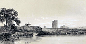 A 1840 depiction of the 12th-centuryTughrul Tower of Ray by French orientalist Eugène Flandin.
 -
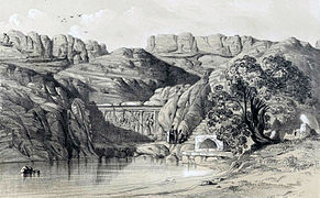 A 1840 depiction of Cheshme-Ali in Ray by French orientalist Eugène Flandin.
 -
 A 1860 depiction of Ray by French orientalist Jules Laurens.
 -
 People spreading washed carpets to dry at Cheshme-Ali in 1960.
 -
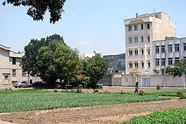 Growing vegetables in a residential area in Ray.
 -
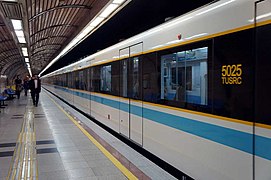 Shahr-e-Rey Metro Station, part of the rapid transit system of Tehran Metro.
 -
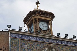 The clock tower of the Shah Abdol-Azim Shrine in Ray.
 -
 Ibn Babawayh Cemetery, named after Shia scholar Ibn Babawayh, in Ray.
 -
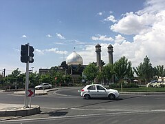
 A view of Abd al-Azim al-Hasani shrine in Ray


_(15025618305).jpg)
_(15002619346).jpg)


See also
References
- ^ Baghbidi 2016, pp. 403–404.
- ^ a b Minorsky & Bosworth 1971, p. 471.
- ^ Judith 1:5, 15; Tobit 1:14, 5:5, 6:10.
- ^ Shahbazi & Bosworth 1990, pp. 768–774.
- ^ Vah and Kohnameh of Iran, Abbas Jafari. Publications of the Institute of Geographical and Cartographic Gitaology. p. 123.
- ^ 38, page 248 and map number 130, Central Alborz, Institute of Geographical and Cartographic Gitaology.
- ^ Map No. 130, Central Alborz. Institute of Geography and Cartography of Gitaology; Geography of Tehran Province. 1363. pp. 35.
- ^ Map 1:50,000, Qom Governorate; map 183 of the Geographical and Cartographic Institute of Gitology, Iran's Mountains and Hills, Abbasi Jafari, p. 453.
- ^ a b Hourade, Bernard (December 15, 2010). "Karaj River". iranicaonline.org. Encyclopaedia Iranica Foundation. Archived from the original on 2010-04-10. Retrieved 2022-02-04.
- ^ a b c d e Rante 2000.
- ^ a b c de Planhol 2004.
- ^ a b Baghbidi 2016, p. 403.
- ^ Strootman 2015.
- ^ Kosmin 2013.
- ^ Olbrycht 2010, pp. 238–239.
- ^ Baghbidi 2016, p. 406.
- ^ Duchesne-Guillemin 1994, pp. 227–229.
- ^ Shahbazi 1991, pp. 365–366.
- ^ Overtoom 2020, p. 254.
- ^ a b Shahbazi 1988, pp. 514–522.
- ISBN 978-90-04-23661-5.
- ISBN 978-90-04-20100-2.as markers of official status (...) the combination is standard, even being reflected in thirteenth-century Coptic paintings, and serves to distinguish, in Grabar's formulation, the world of the Turkish ruler and that of the Arab. (...) The type worn by the official figures in the 1237 Maqāmāt, depicted, for example, on fol. 59r,67 consists of a gold cap surmounted by a little round top and with fur trimming creating a triangular area at the front which either shows the gold cap or is a separate plaque. A particular imposing example in this manuscript is the massive sharbūsh with much more fur than usual that is worn by the princely official on the right frontispiece on fol. 1v.
Reference has already been made to the combination of boots and sharbūsh
- ^ Shahbazi 1987, pp. 851–853.
- ^ Pope, Arthur Upham; Ackerman, Phillis (1964). A Survey of Persian Art from Prehistoric Times to the Present. Vol. 4. Oxford University Press. p. 1532. Archived from the original on 2023-02-27. Retrieved 2019-12-01.
- ^ a b Boyce 1989, p. 198.
- ^ François de Blois (28 November 2011). "DĪVĀN". Encyclopædia Iranica. Vol. VII. pp. 432–438. Archived from the original on 13 April 2014. Retrieved 1 December 2019.
- ^ Floor, Willem (15 December 1990). "ČĀPĀR". Encyclopædia Iranica. Vol. IV. pp. 764–768. Archived from the original on 16 November 2019. Retrieved 1 December 2019.
- ^ Eilers et al. 1983, pp. 229–247.
- ^ a b Alizadeh 1990, pp. 38–39.
- ^ Morimoto, Kazuo (16 March 2015). "KETĀB AL-NAQŻ". Encyclopædia Iranica (online ed.). Archived from the original on 30 September 2020. Retrieved 1 December 2019.
- ^ Scarce 1986, pp. 627–637.
- ^ Hillenbrand 1986, pp. 345–349.
- ^ Brugsch, Heinrich (1862). Reise der Königlich preussischen Gesandtschaft nach Persien 1860 und 1861. Vol. 1. Leipzig. p. 230.
{{cite book}}: CS1 maint: location missing publisher (link) - ^ Madelung, W. (13 July 2011). "ABD-AL-ʿAẒĪM AL-ḤASANĪ". Encyclopædia Iranica. Vol. I. pp. 96–97. Archived from the original on 27 January 2016. Retrieved 18 January 2016.
- ^ Shahvar 2008.
Sources
- Alizadeh, Abbas (1990). "Čašma(-ye) ʿAlī". In ISBN 978-0-939214-66-2.
- Baghbidi, Hassan Rezai (2016). "The Linguistic History of Rayy up to the Early Islamic Period". Der Islam. 93 (2). De Gruyter: 403–412. .
- Boyce, Mary (1989). "Bībī Šahrbānū". In ISBN 978-0-71009-125-3.
- de Planhol, Xavier (2004). "Tehran i. a Persian city at the Foot of the Alborz". Encyclopædia Iranica, online edition. New York.
{{cite encyclopedia}}: CS1 maint: location missing publisher (link) - Duchesne-Guillemin, Jacques (1994). "Deipnosophistaí". In ISBN 978-1-56859-021-9.
- Eilers, W.; Bazin, M.; Bromberger, C.; Thompson, D. (1983). "Abrīšam". Encyclopædia Iranica, online edition, Vol. I, Fasc. 3. New York. pp. 229–247.
{{cite encyclopedia}}: CS1 maint: location missing publisher (link) - Hillenbrand, R. (1986). "Architecture vi. Safavid to Qajar Periods". In ISBN 978-0-71009-104-8.
- .
- OCLC 495469525.
- Olbrycht, Marek Jan (2010). "Mithradates I of Parthia and His Conquests up to 141 B.C.": 229–245.
{{cite journal}}: Cite journal requires|journal=(help) - Overtoom, Nikolaus Leo (2020). Reign of Arrows: The Rise of the Parthian Empire in the Hellenistic Middle East. Oxford: Oxford University Press. ISBN 978-0190888329.
- Rante, Rocco (2000). "Ray i. Archeology". Encyclopædia Iranica, online edition. New York.
{{cite encyclopedia}}: CS1 maint: location missing publisher (link) - Scarce, J. M. (1986). "Art in Iran x.1 Art and Architecture of the Qajar Period". In ISBN 978-0-71009-106-2.
- Shahbazi, A. Sh. (1987). "Astōdān". In ISBN 978-0-71009-108-6.
- Shahbazi, A. Sh. (1988). "Bahrām VI Čōbīn". In ISBN 978-0-71009-117-8.
- Shahbazi, A. Sh.; Bosworth, C.E. (1990). "Capital Cities". In ISBN 978-0-71009-130-7.
- Shahbazi, A. Sh. (1991). "Charax". In ISBN 978-0-939214-71-6.
- Shahvar, Soli (2008). "Railroads i. The First Railroad Built and Operated in Persia". Encyclopædia Iranica, online edition. New York.
{{cite encyclopedia}}: CS1 maint: location missing publisher (link) - Strootman, Rolf (2015). "Seleucid empire". Encyclopædia Iranica, online edition. New York.
{{cite encyclopedia}}: CS1 maint: location missing publisher (link)
External links
- Daily Life Ornamented: The Medieval Persian City Of Rayy Archived 2014-03-14 at the Chicago Oriental Institute(May 15-October 14, 2007).
| Capital | |||||||||||||||||||
|---|---|---|---|---|---|---|---|---|---|---|---|---|---|---|---|---|---|---|---|
| Districts |
| ||||||||||||||||||
| Kahrizak | |||||||||||||||||||
| Qaleh Now |
| ||||||||||||||||||
| Capital | ||||||||||||||||||||||||||||||||||
|---|---|---|---|---|---|---|---|---|---|---|---|---|---|---|---|---|---|---|---|---|---|---|---|---|---|---|---|---|---|---|---|---|---|---|
cities |
| |||||||||||||||||||||||||||||||||
| Landmarks |
| |||||||||||||||||||||||||||||||||
| Populated places | ||||||||||||||||||||||||||||||||||
^* indicates that this formerly independent city is now absorbed into Tehran. | ||||||||||||||||||||||||||||||||||

| International | |
|---|---|
| National | |
| Other | |