Rice Lake National Wildlife Refuge
| Rice Lake National Wildlife Refuge | |
|---|---|
IUCN category IV (habitat/species management area) | |
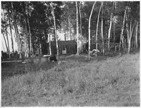
 Rice shacks on Big Rice Lake in 1937 | |
| Location | Aitkin County, Minnesota, United States |
| Nearest city | McGregor, Minnesota |
| Coordinates | 46°31′51″N 93°20′15″W / 46.53078°N 93.33745°W[1] |
| Area | 18,208 acres (73.69 km2) |
| Established | 1935 |
| Governing body | U.S. Fish and Wildlife Service |
| Website | Rice Lake National Wildlife Refuge |
Rice Lake National Wildlife Refuge is located in Aitkin County in east central Minnesota, five miles south of the community of McGregor. It was established in 1935 for waterfowl habitat preservation. The refuge includes Rice Lake itself, a shallow, 3,600-acre wild rice-producing lake. The refuge has been designated as a Globally Important Bird Area by the American Bird Conservancy due to the importance of the lake and its wild rice as a food source to migrating waterfowl, especially ring-necked ducks.[2]
It is managed by the U.S. Fish and Wildlife Service for the conservation and, where appropriate, restoration of fish, wildlife and plant resources and their habitats for the benefit of present and future generations of Americans.[3]
The refuge contains 14 miles of scenic roads and more than 7 miles of walking trails.
References
- ^ "Rice Lake National Wildlife Refuge". Geographic Names Information System. United States Geological Survey, United States Department of the Interior.
- ^ Walker, T. "Rice Lake National Wildlife Refuge". State Parks. Retrieved 2022-11-11.
- ^ "Rice Lake National Wildlife Refuge". FWS.gov. Retrieved 2022-08-17.
![]() This article incorporates public domain material from websites or documents of the United States Fish and Wildlife Service.
This article incorporates public domain material from websites or documents of the United States Fish and Wildlife Service.

