Riddarholmen
 | |
 |
|
 | |
 | |
 |
 |
Riddarholmen (Swedish:
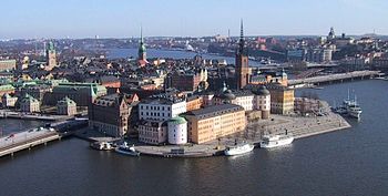
The western end of the island gives a magnificent panoramic and photogenic view of the bay
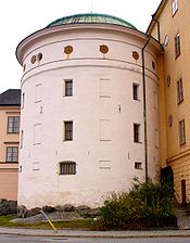
Other notable buildings include the Old Parliament Building in the south-eastern corner, the
Palaces
While the Riddarholm Church dates back to the Middle Ages, and is one of Stockholm's oldest buildings, most of the present structures on Riddarholmen were built during the 17th century when the island was an aristocratic setting that gave the islet its present name. Three of the palaces are gathered around the central public square,
According to a Swedish guide book, these anonymous institutions, together with the motorway Centralbron that isolates the island from the rest of the city, make the island as a whole a lifeless and dull environment, despite ambitious restorations during the 1990s.[1]
Origin of the name
The island is first mentioned as Kidaskär, literally "Kid Skerry", indicating the islet was used to graze goats, in the
The monastery, however, closed following the
Yacht/hotel
- C. K. G. Billings's yacht Vanadis is now anchored at Riddarholmen, and is used as a hotel known as Mälardrottningen with the ship rechristened as Lady Hutton.[3][4][5]
See also
- History of Stockholm
- Geography of Stockholm
- List of streets and squares in Gamla stan
- Riddarholmsbron
- Hebbes Bro
- Birger Jarls torn
References
- ^ ISBN 91-86050-41-9.
- ISBN 91-7031-042-4.
- The Milwaukee Journal. pp. 33, 35. Retrieved 13 December 2014.[permanent dead link]
- ^ Snow, Brook Hill (15 March 1987). "Off The Beaten Path The Lady Hutton, One Of The World's Largest Luxury Yachts, Is Now An Elegant Hotel In Downtown Stockholm". Sun Sentinel. Stockholm, Sweden. Archived from the original on 24 October 2014. Retrieved 18 October 2014.
- ^ Vanadis to Lady Hutton, Kajsa Karlsson (1987).
External links
![]() Media related to Riddarholmen at Wikimedia Commons
Media related to Riddarholmen at Wikimedia Commons

