
Rio Branco, Acre
This article needs additional citations for verification. (March 2012) |
Rio Branco | |
|---|---|
| Município de Rio Branco Municipality of Rio Branco | |
 Clockwise from top left: O Casarão (The Old House), The Rio Branco Palace, Partial view of Rio Branco, Our Lady of Nazareth Cathedral and downtown Rio Branco | |
|
UTC−5 (ACT) | |
| Postal code | 69900-001 to 69924-999 |
| Area code | +55 (68) |
| HDI (2010) | 0.727 – high[2] |
| Website | www |
Rio Branco (Portuguese pronunciation:
In 1913, it became a county. In 1920, it became the capital of the territory of Acre, and in 1962, the state capital. It is the administrative center for the economic, political and cultural region.
History

The capital of the state of
Almost 150 years ago, the construction of workers' shacks had begun, in lands previously occupied by the Aquiri, Canamari, and Maneteri Amazonian indigenous tribes. Years later, the same Gameleira tree survived the battles fought at Volta da Empresa, between Acre revolutionaries and Bolivian troops, during the critical period of the Acre War. As a result, Brazil acquired Acre at the beginning of the 20th century.
By August 1904, Villa Rio Branco had become the main urban center of the entire Acre valley, and was the richest and most productive in the region. During this period of the rubber boom, the streets around the Gameleira were the center of commercial and urban life in this part of the Amazon. Bars, cafes, and casinos supplied the city's nightlife; commercial representatives came here of the chief national and foreign Aviation houses that handled thousands of Contos de Réis. There were many wealthy families in the city.
The urban elite was largely composed of liberal professionals and civil servants. The political administration of the Territory was transferred to the left bank of the Acre River, because its lands were higher and not as subject to
By the 1950s, this older section had become run down and known as the Second District. As a large part of its main commercial houses had transferred to the city's First District, on the left bank of the river, following the construction there of the main public offices and residences of the most important families. Today, Rio Branco is seeking to find ways to reinvent itself, through relations with neighboring countries, developing heritage and eco-tourism, building on the local fish farming industry, and so on.
Geography
Rio Branco is located at 9° 58' 29" south and 67° 48' 36" west, at an altitude of 143 metres (469 ft) above sea level. The city has developed on both sides of the Acre River, with areas known as the First (left bank) and Second Districts. The river is crossed by six bridges, the newest bridge being the Joaquim Macedo Catwalk.
Rio Branco is located in the
Vegetation
The Amazon rainforest represents over half of the planet's remaining rainforests and comprises the largest and most species-rich tract of tropical rainforest in the world. Wet tropical forests are the most species-rich biome, and tropical forests in the Americas are consistently more species rich than the wet forests in Africa and Asia.[3] As the largest tract of tropical rain forest in the world, the Amazonian rainforests have unparalleled biodiversity. More than one-third of all species in the world live in the Amazon rainforest.[4]
The municipality contains part of the 931,537 hectares (2,301,880 acres) Chico Mendes Extractive Reserve, a sustainable use environmental unit created in 1990.[5]
Climate


The city of Rio Branco has the lowest average annual temperature among Legal Amazonian and Northeastern capitals. The city has a tropical monsoon climate, with temperatures between 23 and 33 °C or 73.4 and 91.4 °F during the hottest days of the year. The lowest temperatures occur at night, with frequent records of 22 °C or 71.6 °F at dawn. The period from December to March is the hottest time of year, with highs of 38 °C or 100.4 °F or more. Usually between May and August, the region experiences a cooler weather, registering lower temperatures (around 15 °C or 59 °F) compared to regional standards. In July 2010 the city experienced record low temperatures. On the afternoon of the 17th, temperatures were registered to be 14.7 °C or 58.5 °F on average with a minimum of 12.1 °C or 53.8 °F. The 19th stood out with a minimum at 9.8 °C or 49.6 °F. However, the month's maximum reached 28 °C or 82.4 °F.[6]
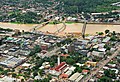
Rio Branco has a lengthy wet season spanning from October through May and a relatively short dry season covering the remaining four months. The city on average sees roughly 1.9 metres or 6 feet 3 inches of rainfall annually. Rio Branco experiences its heaviest rainfall from December through March, averaging over 200 millimetres or 8 inches of precipitation per month during that timeframe. The Acre River has many floodplain spots.
| Climate data for Rio Branco (1991-2020) | |||||||||||||
|---|---|---|---|---|---|---|---|---|---|---|---|---|---|
| Month | Jan | Feb | Mar | Apr | May | Jun | Jul | Aug | Sep | Oct | Nov | Dec | Year |
| Mean daily maximum °C (°F) | 30.9 (87.6) |
30.8 (87.4) |
31.0 (87.8) |
31.2 (88.2) |
30.6 (87.1) |
30.7 (87.3) |
31.8 (89.2) |
33.3 (91.9) |
33.7 (92.7) |
33.1 (91.6) |
32.1 (89.8) |
31.2 (88.2) |
31.7 (89.1) |
| Mean daily minimum °C (°F) | 22.8 (73.0) |
22.6 (72.7) |
22.7 (72.9) |
22.2 (72.0) |
20.8 (69.4) |
19.4 (66.9) |
18.3 (64.9) |
18.9 (66.0) |
20.8 (69.4) |
22.3 (72.1) |
22.6 (72.7) |
22.8 (73.0) |
21.4 (70.4) |
| Average precipitation mm (inches) | 286.1 (11.26) |
298.9 (11.77) |
285.6 (11.24) |
204.3 (8.04) |
98.7 (3.89) |
44.8 (1.76) |
28.2 (1.11) |
57.0 (2.24) |
93.6 (3.69) |
144.0 (5.67) |
208.8 (8.22) |
260.6 (10.26) |
2,010.6 (79.15) |
| Average precipitation days (≥ 1 mm) | 18.4 | 17 | 16.9 | 13.4 | 8.3 | 3.9 | 2.6 | 4.1 | 6.5 | 10.1 | 13 | 17.9 | 132.1 |
| Average relative humidity (%)
|
89.3 | 89.1 | 88.7 | 88 | 87.1 | 85.5 | 81 | 76.7 | 78.2 | 82.6 | 85.5 | 87.8 | 85.0 |
| Average dew point °C (°F) | 24.0 (75.2) |
24.0 (75.2) |
24.1 (75.4) |
23.9 (75.0) |
23.0 (73.4) |
22.0 (71.6) |
20.9 (69.6) |
21.2 (70.2) |
22.5 (72.5) |
23.7 (74.7) |
24.0 (75.2) |
24.1 (75.4) |
23.1 (73.6) |
| Mean monthly sunshine hours | 115.4 | 94.6 | 118.2 | 143.1 | 169.6 | 182.6 | 228 | 202.7 | 175.5 | 167.8 | 143.6 | 122.8 | 1,863.9 |
| Source 1: INMET(Temperatures[7]), (Precipitation[8]), (Humidity[9]), (Dew Point[10]), (Sun[11]) | |||||||||||||
| Source 2: NOAA[12] | |||||||||||||
| Climate data for Rio Branco (1981–2010, extremes 1892–present) | |||||||||||||
|---|---|---|---|---|---|---|---|---|---|---|---|---|---|
| Month | Jan | Feb | Mar | Apr | May | Jun | Jul | Aug | Sep | Oct | Nov | Dec | Year |
| Record high °C (°F) | 36.3 (97.3) |
37.2 (99.0) |
37.2 (99.0) |
38.2 (100.8) |
39.7 (103.5) |
35.2 (95.4) |
37.8 (100.0) |
38.3 (100.9) |
39.2 (102.6) |
38.4 (101.1) |
37.4 (99.3) |
39.8 (103.6) |
39.8 (103.6) |
| Mean daily maximum °C (°F) | 30.9 (87.6) |
30.8 (87.4) |
31.1 (88.0) |
31.0 (87.8) |
30.4 (86.7) |
30.3 (86.5) |
31.3 (88.3) |
32.9 (91.2) |
33.2 (91.8) |
32.9 (91.2) |
31.8 (89.2) |
31.0 (87.8) |
31.5 (88.7) |
| Daily mean °C (°F) | 25.7 (78.3) |
25.5 (77.9) |
25.7 (78.3) |
25.4 (77.7) |
24.4 (75.9) |
23.6 (74.5) |
23.4 (74.1) |
24.6 (76.3) |
25.5 (77.9) |
26.1 (79.0) |
25.9 (78.6) |
25.7 (78.3) |
25.1 (77.2) |
| Mean daily minimum °C (°F) | 22.2 (72.0) |
22.0 (71.6) |
22.0 (71.6) |
21.6 (70.9) |
20.1 (68.2) |
18.3 (64.9) |
17.5 (63.5) |
18.2 (64.8) |
19.8 (67.6) |
21.6 (70.9) |
21.9 (71.4) |
22.2 (72.0) |
20.6 (69.1) |
| Record low °C (°F) | 14.2 (57.6) |
16.0 (60.8) |
14.0 (57.2) |
10.4 (50.7) |
2.6 (36.7) |
7.8 (46.0) |
6.0 (42.8) |
8.0 (46.4) |
10.0 (50.0) |
12.4 (54.3) |
13.6 (56.5) |
13.4 (56.1) |
2.6 (36.7) |
| Average precipitation mm (inches) | 294.4 (11.59) |
298.4 (11.75) |
278.1 (10.95) |
207.4 (8.17) |
87.7 (3.45) |
32.8 (1.29) |
31.9 (1.26) |
56.5 (2.22) |
84.8 (3.34) |
153.0 (6.02) |
206.7 (8.14) |
265.9 (10.47) |
1,997.6 (78.65) |
| Average precipitation days (≥ 1.0 mm) | 19 | 17 | 17 | 13 | 8 | 3 | 3 | 4 | 6 | 10 | 14 | 18 | 132 |
| Average relative humidity (%)
|
88.6 | 88.8 | 88.8 | 88.5 | 87.3 | 85.6 | 81.3 | 77.9 | 78.3 | 82.6 | 85.9 | 88.2 | 85.2 |
| Mean monthly sunshine hours | 109.7 | 90.4 | 113.8 | 127.4 | 154.8 | 174.3 | 218.4 | 180.5 | 158.0 | 162.8 | 138.8 | 118.6 | 1,747.5 |
| Source 1: Instituto Nacional de Meteorologia[13]
| |||||||||||||
| Source 2: Meteo Climat (record highs and lows)[14] | |||||||||||||
Economy
Historically, the economy of Rio Branco has been based on the extraction of rubber and brazil nuts. Currently, wood is the main product of export in the state. It is also a major producer of açaí fruit, copaiba oil and meat. Rio Branco is currently undergoing a transformation in its economy; transformation that includes an expansion to Agribusiness, Aquaculture and Ecotourism. Brazil's largest oil and gas company Petrobras, says the region has potential for future extraction of petroleum.[15][16]
Media
|
|
The city has six newspapers; two are published daily and four weekly. O Tabloide, A Gazeta, Página 20, A Tribuna, and O Estado are weekly newspapers. Cellular carriers who maintain coverage in the region are
.Transportation
.jpg)
The public transport system has improved in recent years, mainly due to the construction of the Terminal Urbano (Urban Bus Terminal) near the center of town. However, the buses are still delayed. Taxis, including motorcycle taxis, are widely used by the population. Rio Branco is the Brazilian state capital city with the largest proportional bike path network per inhabitant in the country.[17]
The
Attractions
The Rio Branco Palace was built in 1930 for the seat of the state government. The building was restored beginning in 1999 to preserve its historical character. In 2008 it was transformed into a museum of history.
Gameleira is a historical site located in the curve of the Acre River, where city was first founded. Today, more than a century later, the strangler fig located there is a vigorous tree, measuring 2.5 metres (8.2 ft) in diameter at the trunk and 20 metres (66 ft) in height.
Opened in 1958, the Cathedral of Our Lady of Nazareth was constructed in the style of an ancient Roman basilica. Its interior has three naves separated by 36 stained-glass windows, donated by families of Acre. The exterior is composed of gables, the cross, and the churchyard. In 2007 the church was considered public property of the state of Acre.

Also known as the Square of the Revolution, Square Plácido de Castro is located in the heart of the city, opposite the headquarters of the Military Police of Acre. Recently, the square underwent renovation. The Autonomists Memorial has a museum, exhibitions of paintings by regional artists, a coffee shop, and a drama theatre. The museum possesses a large collection of historic photos of the state, as well as historical objects used during the Revolution. The Museum of Rubber includes sections on archeology and paleontology, and a historical collection of manuscripts and documents relating to the history of Acre.
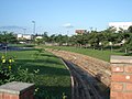
The Catwalk Joaquim Macedo is a pedestrian bridge linking the two districts of the city. Passing over the Acre River, the catwalk is a cable suspension bridge completed in 2006. The nearby Old Market, built in the 1920s, was recently refurbished. Maternity Park was opened on September 28, 2002. It has sports facilities, kiosks, restaurants, biking trails, and skate parks.
Rio Branco has two shopping malls: the Mira Shopping and the Via Verde Shopping, which was completed in 2011.[21]
The sepulcher of Raimundo Irineu Serra, founder of the religion known internationally as Santo Daime, is located in the Alto Santo neighborhood and has become a place of international pilgrimage.
Demographics
The population of the municipality in 2009 was estimated at 305,954 inhabitants by the Brazilian Institute of Geography and Statistics (IBGE), almost half of the population of Acre. It is the largest city in the state and one of Brazil's most populous. The population density of 33.17 inhabitants per square kilometer. According to the 2000 census, 51% of the population are male and 48.2% female; 92.73% of the population lives in urban areas and 7.22% live in rural areas. According to the Atlas of Human Development in Brazil, the population of Rio Branco is 0.16% of the national population. According to the Superior Electoral Court, Rio Branco had 201,966 voters in 2008.
The Municipal Human Development Index of Rio Branco is considered average by the United Nations Development Programme, with a value of 0.754. The education index is 0.860, while Brazil's is 0.849. The rate of longevity is 0.697 (the Brazilian rate is 0.638) and income is 0.704 (Brazil's is 0.723). The Gini coefficient, which measures inequality, is 0.52, where 1.00 is the worst result and 0.00 is the best. The incidence of poverty, as measured by the IBGE, is 37.21 per cent, and the incidence of subjective poverty is 39.39 per cent.
In spite of its remote location, Rio Branco is a pleasant town with a good urban organization, as it is one of the oldest cities in the region, predating other Brazilian inland state capital cities, like: Goiânia, Belo Horizonte, Porto Velho, Brasília, Palmas and Boa Vista.
Education
.jpg)
In 2009 the city of Rio Branco had 211 elementary schools, with 64,349 students and 2,367 teachers. The Index of Basic Education Development for elementary schools was 4.9, ranked 10th among Brazilian capitals, and above the national average of 4.6. There are an estimated 70 kindergarten preschools with 402 teachers and 10,168 students.[citation needed]
Higher education institutions include the Federal University of Acre (UFAC), the Northern Educational Union, the College of the Western Amazonia, and the Community College of Acre, among others. These absorb the bulk of registrations, especially the Federal University of Acre, as the only public college in the state.
In 2008, the illiteracy rate in the state was 13 per cent, with 36.2 per cent of the population functionally illiterate.
Sports

Rio Branco provides visitors and residents with various sport activities. The three main football teams in Acre are based in Rio Branco: Rio Branco FC, Juventus and Atlético Acreano. Stadiums in the city are the Arena da Floresta stadium; José de Melo stadium; Federação Acreana de Futebol stadium; Dom Giocondo Maria Grotti stadium; and Adauto de Brito stadium. Rio Branco was one of 18 candidates shortlisted to host games of the 2014 FIFA World Cup, for which Brazil was the only South American bidder. The city's bid was rejected.
Sister cities
Notable people
- Enéas Carneiro, politician
- Carlão, brazilian volleyball player, Olympic champion
- Weverton Pereira da Silva, football player
- João Donato, musician
Image gallery
-
 Aerial view of old town Rio Branco, Brazil
 -
 Rio Branco in the afternoon
 -
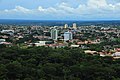
 View of the city centre
 -
 View of Rio Branco, Acre
 -
 Historic houses of Rio Branco, Brazil
 -
 Rio Branco, Brazil
 -
 Canal da Maternidade, Rio Branco of Acre
 -
 Via Verde ring road, Rio Branco, Brazil
 -
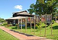 Casa dos Povos da Floresta Museum, Rio Branco, Brazil
 -
 Downtown Rio Branco, the city's Old Market (Mercado Velho), Brazil
 -
 Event at Palácio Rio Branco, Rio Branco, Brazil
 -
 Flood of Acre River, Rio Branco, Brazil


.jpg)


.jpg)

References
- ^ a b IBGE 2021
- ^ "Archived copy" (PDF). United Nations Development Programme (UNDP). Archived from the original (PDF) on July 8, 2014. Retrieved August 1, 2013.
{{cite web}}: CS1 maint: archived copy as title (link) - ISBN 0-521-80183-4
- ^ "Biomes | Conserving Biomes | WWF". World Wildlife Fund. Retrieved 3 August 2023.
- ^ Unidade de Conservação: Reserva Extrativista Chico Mendes (in Portuguese), MMA: Ministério do Meio Ambiente, retrieved 2016-06-04
- ^ "World Weather Information Service - Rio Branco". worldweather.wmo.int. Retrieved 3 August 2023.
- Instituto Nacional de Meteorologia. Retrieved 2024-01-13.
- "Normal Climatológica do Brasil 1991-2020: Temperatura Mínima Mensal e Anual (°C)" (XLSX). portal.inmet.gov (in Portuguese). Instituto Nacional de Meteorologia. Retrieved 2024-01-13.
- "Temperatura Média Compensada Mensal e Anual (°C): Período: 1991-2020" (XLSX). portal.inmet.gov (in Portuguese). Instituto Nacional de Meteorologia. Retrieved 2024-01-14.
- ^ "Precipitação Acumulada Decendial Mensal e Anual (mm) Period:1991-2020" (XLSX). portal.inmet.gov (in Portuguese). Instituto Nacional de Meteorologia. Retrieved 2024-01-13.
- ^ "Umidade Relativa do Ar Compensada Mensal e Anual (%): Período: 1991-2020" (XLSX). portal.inmet.gov (in Portuguese). Instituto Nacional de Meteorologia. Retrieved 2024-01-14.
- Instituto Nacional de Meteorologia. Retrieved 2024-01-13.
- Instituto Nacional de Meteorologia. Retrieved 2024-01-13.
- NOAA. Retrieved 2024-01-14.
- ^ "Normais Climatológicas Do Brasil 1981–2010" (in Portuguese). Instituto Nacional de Meteorologia. Retrieved 20 October 2018.
- ^ "Station Rio Branco" (in French). Meteo Climat. Retrieved 20 October 2018.
- ^ "Petrobras - Fatos e Dados - Blocos na Bacia do Acre e exploração de gás de xisto: respostas à Folha de S. Paulo". Archived from the original on 2020-06-23.
- ^ "Brazil Petroleum Product Sales: Acre: Barrel: Diesel | Economic Indicators | CEIC".
- ^ "Malha cicloviária das capitais cresce 133% em 4 anos e já passa de 3 mil quilômetros - G1". Archived from the original on 2020-06-23.
- New York Times.
- ^ "In Rio Branco, the 46th ExpoAcre brings together more than 100 zebus on the track".
- ^ "Productores urubambinos participan en la ExpoAcre 2022, una de las ferias más importantes de Brasil (Urubamba producers participate at ExpoAcre 2022, one of the most important fairs in Brazil)". Government of Peru.
- ^ "Shopping Viaverde Online". Viaverdeshopping.com.br. Retrieved 2022-08-26.
- ^ "Censo 2022 - Panorama".
External links
 Definitions from Wiktionary
 Media from Commons
 News from Wikinews
 Quotations from Wikiquote
 Texts from Wikisource
 Textbooks from Wikibooks
 Resources from Wikiversity
 Travel information from Wikivoyage
- Prefeitura de Rio Branco Rio Branco's municipal government
- [1] Hotels in Rio Branco

| International | |
|---|---|
| National | |
| Geographic | |