
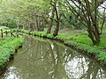
River Bourne, Addlestone

Urban areas are not shaded.
The River Bourne is the name given to a Thames tributary in northwest Surrey, England which has a longer tributary, the Windle Brook, that rises nears Bagshot Park in the south of Swinley Forest, Berkshire, merging with it while flowing through villages north of Woking; downstream the Bourne joins the Thames near Weybridge.
Course
The River Bourne or The Bourne rises southwest of
Along its lower course, past
Upper Tributaries
Windle Brook
The Windle Brook is a small river springing at New England Hill,
This stream goes straight eastward until before the
The Hale Bourne, Lightwater and Chobham
In a hilly, well-wooded strip of public heath adjoining the off-limits Pirbright Ranges Heath to the south, in Lightwater, the Hale Bourne springs which forms a small lake, Lightwater, surrounded by houses and its flow turns east when it takes on a greater amount of water from the Windle Brook below Broadway Green, Windlebrook and Rectory Farms in Lightwater; then this enlarged Hale Bourne flows into Chobham where it becomes joined by a tributary and known as the Mill Bourne.[4]
The Mill Bourne, Chobham
As soon as joined by Clappers Brook in west Chobham the Hale becomes the Mill Bourne. It passes a recreation ground and Millbourne Bridge through the village centre picking up two main tributaries from the north (as the south is drained by The Bourne, see above), the only named one is Clappers Brook.[n 4][2] In this straight the Mill Bourne passes Town Mill, the Chobham Museum, Sow Moor and Emmett's Mill before reaching a confluence with The Bourne. This confluence is between the McLaren Technology Centre grounds and Fairoaks Airport.
Knaphill and Parley Brooks
Waterer's Park[n 5] marks the start of an additional stream flowing north from Knaphill, the northern suburb of Woking forming a confluence west of Horsell Common. Just before the confluence is the confluence of the Parley Brook that stems from the Goldsworth Park recreation ground.[2]
Flood Risk
During 12–14 August 2006, much of the civil parish of
Concerns were express by residents to the
Surrounding Soil, Elevations and Rainfall
The two main watercourses are once past Lightwater/Bisley 2.5–5 m wide flowing over land which is geologically the remains of the sandy Bagshot or Western Surrey formation, where sands and organic matter overlie clay, described as "slowly permeable loamy or peat soils" or "loamy and clayey soils with naturally high groundwater" surrounded by "free-draining naturally wet heath" on higher land, making in the uplands swathes unique, heather, gorse and coniferous habitat interspersed with bogs and brooks.[9]
At Chobham the widest plain of surrounding land forms which is, as drained by ditches and less acidic, fertile and widely used for cultivation. Elevations range as follows:
| Elevation of Bourne at centre | Settlement passed | Elevations of centre of settlement[10] |
|---|---|---|
| 53m ("Windle Brook") | Bagshot | 55-91m |
| 41.5m ("Windle Brook") | Windlesham Arboretum | 42-46m |
| 43.5m ("Hale Bourne") | Lightwater | 45.3-60m |
| 31—33m (River Bourne) | Bisley | 36m-55m |
| 30—32m (River Bourne) | West End |
31.7-42m (mostly 33-42m) |
| 25m (River Bourne) | Chobham (High Street south of Church) | 26—27.2m |
| 27.2m ("Mill Bourne") | Chobham (High Street and all areas off Windsor Road north of Church) | 27.5-39m |
| 15–15.5m | New Haw Golf Fun and Driving Range | 15.5-16.2m |
| 11.5–14m | Addlestone | 13-21m |
Local annual rainfall is about 635 mm.[citation needed]
-
 Field adjoining the Mill Bourne
 -
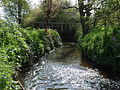
 Mill Bourne
east stretch
at Emmett's Mill -
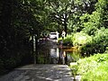
 Mill Bourne
west stretch by the Village Mill -
 Mill Bourne
west stretch -


Fishing
Being capable of the grant of private land fishing rights by all adjoining landowners, not being a navigable river, several fishing groups use the river without need for government body permits.
Bourne Anglers, for instance is a small fishing club/conservation group, started in 2013. The club has been set up to maintain the river and with kind permission of various landowners has kept stretches a free fishing river.
See also
Notes and references
- Notes
- ^ Specifically in the western part of Bisley Common, part of the Ministry of Defence Pirbright Ranges. Bisley Common denotes two commons; the one that has these headwaters does not refer to the full public access common also known as "Reidon Hill" by Knaphill.
- ^ The Chobham and Pirbright Commons a Surrey Wildlife Trust area most of which is a military training area includes such areas as Strawberry Hill, Strawberry Bottom, Colony Bog, Lovelands Hill and Brock Hill
- ^ Bisley and West End both have the Ranges and Heath to the west
- Valley End, Surreywest of Staple Hill the highest point of Chobham Common
- ^ Waterer's Park is a public park
- References
- ^ Note that KT15 reveals Addlestone includes Woburn Park — as when it was one parish, Chertsey, Addlestone on all boundaries occupies almost all land west of the River Wey
- ^ a b c d Map created by Ordnance Survey, courtesy of English Heritage
- ^ Surrey Wildlife Trust - Windlesham Arboretum
- ^ Rectory Farm Grade II* architectural listing entry and map in Lightwater Historic England. "Details from listed building database (1030001)". National Heritage List for England. Retrieved 16 November 2012.
- ^ Surrey Heath Borough Council - Flood info
- ^ 2006 Flood news
- ^ Campaign to Protect Rural England
- ^ Government News Network
- ^ National Soil Resources Institute – Cranfield University
- ^ Grid reference Finder measurement tools
External links
51°22′43″N 0°27′50″W / 51.3785°N 0.4639°W
