River Hayle
| River Hayle | |
|---|---|
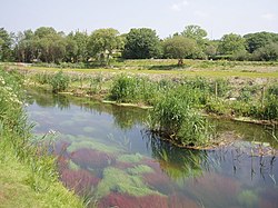
 River Hayle near St Erth | |
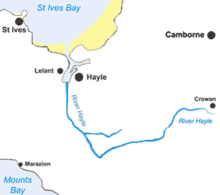
 Map of the course of the River Hayle | |
| Location | |
| Country | United Kingdom |
| Region | Cornwall |
| Physical characteristics | |
| Source | |
| • location | Crowan |
| • coordinates | 50°9′25.2″N 5°16′58.8″W / 50.157000°N 5.283000°W |
| Mouth | Hayle Estuary |
• location | Hayle, St Ives Bay |
• coordinates | 50°11′31″N 5°26′6″W / 50.19194°N 5.43500°W |
The River Hayle (Cornish: Heyl, meaning estuary) is a small river in West Cornwall, England, United Kingdom which issues into St Ives Bay at Hayle on Cornwall's Atlantic coast.[1]
The River Hayle is approximately 12 miles (19 kilometres) long and it rises south-west of Crowan village. Its course is west for approximately 5 miles (which brings the river to within 3 miles of the south coast at Marazion on Mount's Bay). It then flows through a steep wooded valley north of the granite high ground at Trescowe Common, formerly a mining area, before turning abruptly north near the hamlet of Relubbus. It then follows a northerly course for the remaining six miles to the estuary, passing St Erth.
The
sites of special scientific interest (see also Hayle SSSI
).
River Hayle location information
- Mouth: Coordinates 50°11′31″N 5°26′06″W / 50.192°N 5.435°W; grid reference SW 548 382
- Relubbus (major change of course): Coordinates 50°08′02″N 5°24′04″W / 50.134°N 5.401°W; grid ref. SW 570 315
- Source: Coordinates 50°09′25″N 5°16′59″W / 50.157°N 5.283°W; grid ref. SW 656 338
References
- ISBN 978-0-319-23148-7
- ^ "Hayle Estuary". RSPB Reserves. RSPB. 28 April 2009. Retrieved 9 February 2010.
Wikimedia Commons has media related to River Hayle.
