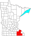
Rochester metropolitan area, Minnesota
Rochester, Minnesota MSA | |
|---|---|
CDT ) |
The United States Census Bureau defines the Rochester, Minnesota Metropolitan Statistical Area (MSA) as an area consisting of five counties in southeast Minnesota, anchored by the city of Rochester. As of 2018, the US Census Bureau estimates that the Rochester metropolitan statistical area has a population of 221,587. The Rochester–Austin combined statistical area has a population of 259,813 as of 2018.
Counties
Communities
Cities
- Places with more than 100,000 inhabitants: Rochester.
- Places with 2,500 to 10,000 inhabitants: Byron, Chatfield, Dodge Center, Kasson, Lake City (partial), Pine Island (partial), Plainview, Stewartville, Wabasha.
- Places with 1,000 to 2,500 inhabitants: Blooming Prairie (partial), Eyota, Grand Meadow, Harmony, Hayfield, Mantorville, Oronoco, Preston, Rushford, Spring Valley.
- Places with less than 1,000 inhabitants: Bellechester (partial), Canton, Claremont, Dover, Elgin, Fountain, Hammond, Kellogg, Lanesboro, Mabel, Mazeppa, Millville, Minneiska (partial) Ostrander, Peterson, Racine, Rushford Village, West Concord, Whalan, Wykoff, Zumbro Falls.
- Unincorporated places: Douglas, Simpson, South Troy, Potsdam, Berne, Salem Corners, Chester, Pleasant Grove, Genoa, Post Town, Danesville
Townships
- Townships with more than 2,500 inhabitants: Rochester.
- Townships with 1,000 to 2,500 inhabitants:Oronoco, Salem.
- Townships with 500 to 1,000 inhabitants: Zumbro.
- Townships with less than 500 inhabitants: Westfield.
Demographics
As of the
The median income for a household in the MSA was $46,957, and the median income for a family was $55,450. Males had a median income of $35,815 versus $26,738 for females. The per capita income for the MSA was $21,287.
Transportation
Highways
Interstate Highways
US Highways
- U.S. Highway 14
- U.S. Highway 52
- U.S. Highway 61
- U.S. Highway 63
- U.S. Highway 218(briefly runs through Dodge County)
Minnesota State Highways
 Minnesota State Highway 16
 Minnesota State Highway 30
 Minnesota State Highway 42
 Minnesota State Highway 43
 Minnesota State Highway 44
 Minnesota State Highway 56
 Minnesota State Highway 57
 Minnesota State Highway 60
 Minnesota State Highway 74
 Minnesota State Highway 80
 Minnesota State Highway 139
 Minnesota State Highway 247
 Minnesota State Highway 250
Public Airports
Commercial
General Aviation
Government and politics
Federal Representation
All of the Rochester metropolitan area falls in
State Senate Legislators
The following list shows the Rochester metropolitan area's representation in the Minnesota Senate:
| Name | District | First Elected | Party | County Represented within MSA |
|---|---|---|---|---|
| Steve Drazkowski | District 20 | 2022 | Republican | Goodhue, Wabasha, Olmsted |
| Gene Dornink | District 23 | 2020 | Republican | Mower |
| Carla Nelson | District 24 | 2010 | Republican | Dodge, Olmsted |
| Liz Boldon | District 25 | 2022 | DFL | Olmsted |
| Jeremy Miller | District 26 | 2010 | Republican | Fillmore, Mower |
See also
- Minnesota census statistical areas
References
- ^ "U.S. Census website". United States Census Bureau. Retrieved 2008-01-31.


