Rose Atoll Marine National Monument
| Rose Atoll Marine National Monument | |
|---|---|
IUCN category V (protected landscape/seascape) | |
 Oceanographers deploy a buoy inside Rose Atoll | |
Location of Rose Atoll in Oceania | |
| Coordinates | 14°32′45″S 168°09′00″W / 14.5458333°S 168.15°W |
| Area | 8,571,633 acres (3,468,817 ha)[1] |
| Created | 2009 |
| Governing body | U.S. Fish and Wildlife Service |
| Website | Rose Atoll Marine National Monument |
Rose Atoll Marine National Monument is a United States National Monument in the South Pacific Ocean, covering 8,571,633 acres (13,393.18 sq mi; 10,113.45 sq nmi; 34,688.17 km2)[1] and encompassing the Rose Atoll National Wildlife Refuge, which was established in 1973 with 39,066 acres (61.04 sq mi; 46.09 sq nmi; 158.09 km2), only 20 acres (8.1 ha) of which is emergent. The monument's marine areas are likely to also be incorporated in the National Marine Sanctuary of American Samoa.
Office of National Marine Sanctuaries, a component of the National Oceanic and Atmospheric Administration
(NOAA).
 |
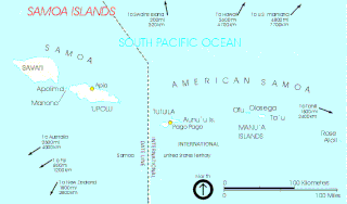
Map of the Samoan Islands, showing the location of Rose Atoll
|
See also
References
- ^ a b "Annual Report of Lands as of September 30, 2010" (PDF). United States Fish and Wildlife Service. Retrieved 2012-03-18.
- ^ "Bush Conserves Vast Areas of Pacific Ocean as Monuments". Environment News Service International Daily Newswire. ENS. 6 January 2009. Retrieved 24 November 2010.
External links
- Rose Atoll Marine National Monument – FWS
- Rose Atoll National Wildlife Refuge
- Rose Atoll Marine National Monument – NOAA Fisheries
- Rose Atoll National Wildlife Refuge Planning Update
- Copy of official map of National Monument designation (PDF)
- White House Press Release on Monument Designation


