
Rosetta
Rosetta
رشيد Rashid | |
|---|---|
UTC+3 (EEST ) |
Rosetta (
Founded around the 9th century on site of the ancient town Bolbitine, Rosetta boomed with the decline of Alexandria following the
Etymology
The name of the town most likely comes from an Arabic name
Some scholars believe that there is no evidence that the city's name comes from
History
In Antiquity Bolbitine was celebrated for its manufactory of chariots.[6]
Iban Haqal mentioned it and said that it is a city on the Nile, close to the salt sea from a crater known as Ashtum (
Despite the similarity of Rashid and Damietta in their geographical and administrative position throughout the ages and as an important coastal city, Rashid did not play a clear, influential role compared to Damietta's role in the beginnings of Arab Islamic rule, especially for Rashid's proximity to the location of Alexandria, which is the first coastal city in Egypt and primarily affected Rashid and its position. Likewise, the agricultural area in Rashid is very limited, and the spread of sand formations to the west of the city and its urbanization has a greater impact on the city and its agriculture; As a result, Rashid was deserted several times by its residents and they took refuge in Fuwwah, in the south.[7]
What is now known today as Rosetta was an
Following the establishment of the Fatimid state in 969, and the establishment of the city of Cairo as the new capital of the country, foreign trade was active that was no longer limited to Alexandria only. Rather, Rashid and Damietta participated in it, especially in the beginnings of the Fatimid state, which made urbanism restart.[9]
In the era of the Ayyubid state, neighboring Alexandria witnessed extensive commercial activity as a result of the concessions granted by the Ayyubids to Italian merchants, and before the Bay of Alexandria was re-cleared in 1013 in the Fatimid era by order of Al-Hakim bi-Amr Allah, which contributed to linking Alexandria to the city of Fuwwah, south of Rashid and overlooking the Nile. And from it to Cairo and the rest of the cities of Egypt, and this led to the flourishing of the commercial activity of Fuwwah, which affected the movement of trade Rashid, so that in the era of the Mamluks Fuwwah became the base of the trade networks in the region.[10]
During the
Rashid contributed to the launching of the naval campaigns during Sultan
Under the
Geography
The city is located 65 km (40 mi) east of Alexandria, in Egypt's Beheira governorate.
Climate
]| Climate data for Rosetta | |||||||||||||
|---|---|---|---|---|---|---|---|---|---|---|---|---|---|
| Month | Jan | Feb | Mar | Apr | May | Jun | Jul | Aug | Sep | Oct | Nov | Dec | Year |
| Mean daily maximum °C (°F) | 18.8 (65.8) |
18.9 (66.0) |
20.9 (69.6) |
24 (75) |
27.2 (81.0) |
29.3 (84.7) |
30.7 (87.3) |
31.5 (88.7) |
30.5 (86.9) |
28.8 (83.8) |
25 (77) |
20.8 (69.4) |
25.5 (77.9) |
| Daily mean °C (°F) | 14.5 (58.1) |
14.4 (57.9) |
16 (61) |
18.6 (65.5) |
21.8 (71.2) |
24.4 (75.9) |
26.2 (79.2) |
26.9 (80.4) |
25.9 (78.6) |
23.9 (75.0) |
20.3 (68.5) |
16.4 (61.5) |
20.8 (69.4) |
| Mean daily minimum °C (°F) | 10.2 (50.4) |
10 (50) |
11.2 (52.2) |
13.2 (55.8) |
16.4 (61.5) |
19.5 (67.1) |
21.7 (71.1) |
22.4 (72.3) |
21.3 (70.3) |
19 (66) |
15.7 (60.3) |
12 (54) |
16.1 (60.9) |
| Average precipitation mm (inches) | 50 (2.0) |
26 (1.0) |
13 (0.5) |
4 (0.2) |
3 (0.1) |
0 (0) |
0 (0) |
0 (0) |
0 (0) |
9 (0.4) |
25 (1.0) |
51 (2.0) |
181 (7.2) |
| Source: climate-data.org[14] | |||||||||||||
Population
The population of Rosetta has increased since the 1980s, as follows:
- 1983: 36,711 (approximate)
- 1986: 51,789
- 1996: 58,432
Gallery
-
 An identical copy of the Rosetta Stone
 -
 Abou Mandour Mosque
 -
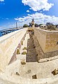
 Rashid old walls
 -
-
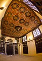 Old houses indoors
 -
 Beit Ramadan
 -
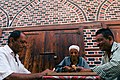 Playing Dominoes


.jpg)

Notes
References
- ^ a b c "Rashīd (Markaz, Egypt) - Population Statistics, Charts, Map and Location". www.citypopulation.de. Retrieved 17 March 2023.
- ^ James Talboys Wheeler, The geography of Herodotus, 1854, p. 363
- ^ a b c Peust, Carsten (2010). Die Toponyme vorarabischen Ursprungs im modernen Ägypte. Göttingen. p. 75.
{{cite book}}: CS1 maint: location missing publisher (link) - ^ a b Forster, E. M. (2021). Alexandria: A History and a Guide. Prabhat Prakashan.
- ISBN 9789042941755.
- ^ "Dictionary of Greek and Roman Geography (1854), BOLBIT´INE". www.perseus.tufts.edu. Retrieved 5 October 2022.
- ^ محمد طاهر الصادق ومحمد حسام إسماعيل، مرجع سابق، صـ: 39.
- The Coptic Encyclopedia, vol. 2, New York: Macmillan Publishers, cols. 349b–351b.
- ^ شهاب الدين أبي عبد الله ياقوت بن عبد الله الحموي، معجم البلدان: الجزء الثالث، دار الفكر، بيروت، صـ: 45.
- ^ سعيد عبد الفناح عاشور، مصر في العصور الوسطى، ـــــ، القاهرة، 1970، صـ: 404.
- ^ Peter Jackson, The Seventh Crusade, 1244–1254: Sources and Documents, Volume 16 of Crusade Texts in Translation, Ashgate Publishing, Ltd., 2009, p. 72
- ^ نقولا يوسف، دمياط منذ أقدم العصور، الاتحاد القومي بدمياط، دمياط، 1959، صـ: 159
- ^ جمال الدين أبي المحاسن يوسف بن تغري بردي الأتابكي، النجوم الزاهرة في ملوك مصر والقاهرة: الجزء 15، الهيئة العامة لقصور الثقافة، القاهرة، صـ: 334.
- ^ "Climate: Rosetta – Climate graph, Temperature graph, Climate table". climate-data.org. Retrieved 13 August 2013.
Bibliography
- "Rosetta", Encyclopaedia Britannica, Chicago, 1983.
External links
- Thomas Brinkhoff: City Population Egypt statistics
- Detailed map of Egypt (with many ancient temples): UniMaps-Egypt.
| 1,000,000 and more | |
|---|---|
| 300,000–999,999 | |
| 100,000–299,999 | |
| <99,999 |
|

| International | |
|---|---|
| National | |