
Route 1 (Hong Kong)
 | ||||
|---|---|---|---|---|
Aberdeen Praya Road in Aberdeen | ||||
| North end | ||||
| Location | ||||
| Country | China | |||
| Special administrative region | Hong Kong | |||
| Districts | Southern, Central and Western, Wan Chai, Yau Tsim Mong, Kowloon City, Wong Tai Sin, Sha Tin | |||
| Highway system | ||||
| ||||
Route 1 (Chinese: 一號幹線) is a major artery in Hong Kong that runs in a generally north-south direction, connecting Aberdeen with Sha Tin.
The route is heavily congested, notably on the Canal Road viaduct that links the Aberdeen Tunnel with the Cross-Harbour Tunnel in Causeway Bay.[1] Route 1 continues to serve as the most direct route from the north shore of Hong Kong Island to the Southern District. The road travels across the harbour and runs through the middle of Kowloon and continues heading north into the New Territories.
Route
Southern District
The route begins at the eastern end of
Route 1 continues along Wong Chuk Hang Road, with a short viaduct over the intersection with Nam Long Shan Road. At the end of the viaduct, there is another trumpet interchange connecting Ocean Park. The route then enters a T-interchange, where Wong Chuk Hang Road diverges from Route 1 and continues towards Repulse Bay and Stanley. Route 1 instead heads northeast towards Aberdeen Tunnel, the only highway tunnel connecting northern and southern Hong Kong Island. After passing through the toll plaza, the route enters the southern tunnel portal.
-
 Interchange with Ap Lei Chau Bridge
 -
 Wong Chuk Hang Road and viaduct at night
 -
 Aberdeen Tunnel southern portal


Wan Chai District
Upon leaving the tunnel, traffic runs on the Wong Nai Chung Gap Flyover[a] after exiting the tunnel at Happy Valley, running above Wong Nai Chung Road. At this point, a diamond interchange connects Wan Chai and Causeway Bay with Route 1 via Queen's Road East and Leighton Road.
Route 1 then continues into the Canal Road Flyover, with another pair of on/off-ramps outside Times Square accessible from the north. It then descends to the ground level into Wan Chai Interchange, a complete interchange intersecting with Gloucester Road (part of Route 4 before 2019), allowing traffic to head west into Admiralty and Central; or eastwards to Tin Hau and further onto the Island Eastern Corridor.
The route then heads into the
-
 Wong Nai Chung Gap Flyover (top) and Wong Nai Chung Road (bottom)
 -
 Canal Road Flyover
 -
 Wan Chai Interchange before the opening of the tunnel
 -
 Inside the Cross-Harbour Tunnel


Kowloon
Upon reaching Kowloon, Route 1 passes through the toll plaza and bus interchange of the Cross-Harbour Tunnel, situated between Hung Hom station and the Polytechnic University. It then merges into Hong Chong Road, a short trunk road that ends at the junction with Chatham Road North (Route 5), where traffic to/from the Cross-Harbour Tunnel is connected with both directions of Route 5 via ramps laid out in a trumpet interchange fashion. Immediately after this junction, Route 1 is joined by traffic from Chatham Road South and Hung Hom Bypass.
At this point, route 1 continues to head north on
Route 1 then continues northwards, cutting through the middle of Kowloon Tong. The stretch between Flint Road and Suffolk Road is the only section of the route that is not a controlled-access highway, with numerous signal-controlled intersections. After Suffolk Road, Route 1 enters a 650m-long overhead viaduct, allowing grade separation from the ground-level intersections with Junction Road and Cornwall Street.
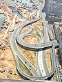
After leaving Kowloon Tong, Route 1 climbs a steep, curvy incline to reach a partial clover interchange with Lung Cheung Road (Route 7), where ramps allow traffic from both directions of Route 7 to merge into Route 1 towards the north. Route 1 then heads into the 1.4km-long Lion Rock Tunnel, travelling under Lion Rock and heading into the New Territories.
-

-
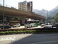
 Traffic congestion at Hong Chong Road
 -
 Princess Margaret Road near Hong Kong Metropolitan University
 -
 Waterloo Road at Kowloon Tong
 -
 Southern portals of Lion Rock Tunnel


Sha Tin
After passing through the toll plaza at the northern end of the tunnel, Route 1 continues into Lion Rock Tunnel Road, continuing in a northeastern direction roughly along the eastern edge of the Sha Tin New Town. It then intersects with Hung Mui Kuk Road at a trumpet interchange, which continues into Tai Wai. After passing Sun Tin Wai Estate, Route 1 then runs along Sha Tin Road, diverging from Lion Rock Tunnel Road which heads into Sha Tin town centre instead.
The remaining 3 km section along Sha Tin Road is the only expressway section of Route 1. At Sha Tin Wai, the Sha Lek Highway splits off, heading towards an interchange with Route 2 towards Ma On Shan or Kowloon East. This is immediately followed by a diamond interchange with Sha Tin Wai Road. The route then turns northwards, passing by City One with a partial diamond interchange leading onto Tai Chung Kiu Road. It then crosses over the Shing Mun River via the 500m-long Dragon Bridge.
Across the river, Route 1 reaches another partial diamond interchange with Yuen Wo Road, accessible from the northern side. It then joins Tai Po Road - Sha Tin at Fo Tan, where the traffic continues northwards via Route 9 towards Tai Po and Fanling. On the northbound direction, Route 1 continues along Tai Po Road for another 250m as the outermost vehicular lane, reaching another exit ramp towards Penfold Park before merging into Route 9.
-
 Lion Rock Tunnel toll plaza
 -
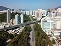 Sha Tin Road passing under Tuen Ma line tracks
 -
 Dragon Bridge


History
Route 1 was established in January 2004 when the third generation of route numbers came into use, replacing the old system which had been used since 1974.[citation needed]
Future
Expansion of Lion Rock Tunnel
The Highways Department has proposed to enlarge the existing Lion Rock Tunnel and widen its connecting roads,[2] in order to refurbish the tunnels which has shown signs of aging and deterioration, as well as to help alleviate congestion around the tunnel and adjacent sections of Route 1.[3]
Upon completion, the existing southbound tube will be refurbished and widened to three lanes, and a new three-lane tube will be constructed between the existing tubes, taking over the northbound traffic. The existing northbound tube (Second Lion Rock Tunnel) will be taken out of regular use, and serves as a backup carriageway during emergencies.
The project is currently expected to start construction by 2025 and projected to be fully open by 2033.[5]
Trunk Road T4
The proposed Trunk Road T4, which is currently under design works,[6] will be connected to the Route 1. Diverging from Sha Tin Road to the west outside Pok Hong Estate, the new route would cross the Shing Mun River and merge into Tsing Sha Highway (Route 8) and Shing Mun Tunnels (Route 9). In addition, an entrance slip road from Lion Rock Tunnel Road outside Tsang Tai Uk towards northbound Sha Tin Road will be built.[6] Construction is expected to start in late 2023.[7]
Exit list
| District | Location | km[8] | mi | Exit | Destinations | Notes |
|---|---|---|---|---|---|---|
| Southern | Aberdeen | 0.0 | 0.0 | — | Aberdeen Praya Road - Aberdeen, Pok Fu Lam | Southern terminus |
| 0.0– 0.2 | 0.0– 0.12 | 1 | Ap Lei Chau Bridge | |||
| Wong Chuk Hang | 0.2 | 0.12 | 1A | Heung Yip Road | Southbound only | |
| 0.4 | 0.25 | — | Yip Kan Street | Yip Kan Street to southbound only | ||
| 0.5– 1.1 | 0.31– 0.68 | 2 | Wong Chuk Hang Road to Nam Long Shan Road | |||
| 1.2– 1.3 | 0.75– 0.81 | 3 | Ocean Park Road | |||
| 1.4– 2.0 | 0.87– 1.2 | 4 | Wong Chuk Hang Road / Nam Fung Road | No access to/from southbound | ||
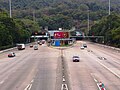
| 2.1 | 1.3 | Aberdeen Tunnel Toll Plaza | ||||
| Southern– Wan Chai | Wong Chuk Hang– Happy Valley | 2.3– 4.2 | 1.4– 2.6 | Aberdeen Tunnel | ||
| Wan Chai | Morrison Hill | 4.3– 4.9 | 2.7– 3.0 | 5 | Wong Nai Chung Road | To/from Route 1 northbound only |
| East Point | 5.3 | 3.3 | 5A | Canal Road West / Canal Road East | To/from Route 1 southbound only | |
| 5.4– 5.9 | 3.4– 3.7 | 6 | Gloucester Road - Central, Wan Chai Victoria Park Road - Tin Hau, North Point, Kowloon East | |||
| Wan Chai– Yau Tsim Mong | East Point– Hung Hom Bay | 6.0– 7.8 | 3.7– 4.8 | Cross-Harbour Tunnel | ||
| Yau Tsim Mong | Hung Hom | 8.1 | 5.0 | Cross-Harbour Tunnel Toll Plaza | ||
| 8.2 | 5.1 | — | Hong Chong Road | Hong Chong Road to northbound Route 1 only | ||
| 8.4 | 5.2 | 6A | Salisbury Road | Southbound only | ||
| 6B | Railway Approach | Southbound only | ||||
| 6C | Route 1 northbound to Route 5 westbound | |||||
| 8.6 | 5.3 | 6D | Route 1 northbound to Route 5 eastbound | |||
| No. 12 Hill | 9.0 | 5.6 | 7A | Princess Margaret Road | To/from Route 1 northbound only | |
| 7B | Princess Margaret Road Link | To from Route 1 northbound only | ||||
| Kowloon City | 9.1– 9.4 | 5.7– 5.8 | 7D | Chi Man Street | Southbound only | |
| Yau Tsim Mong | 9.3 | 5.8 | 7C | Wylie Road | Northbound only | |
| Kowloon City | 9.7 | 6.0 | 7E | Chung Man Street | Southbound only | |
| Ho Man Tin | 10.0 | 6.2 | 8 | Man Fung Path / Sheung Hing Street to Pui Ching Road | No access to Route 1 southbound from Pui Ching Road westbound | |
| — | Princess Margaret Road to Argyle Street | To/from southbound Route 1 only | ||||
| 11.0 | 6.8 | 8A | Waterloo Road | |||
| — | Boundary Street | Boundary Street to Route 1 southbound only | ||||
| 8B | Prince Edward Road West | Southbound only | ||||
| Kowloon Tong | 8C | Waterloo Road | ||||
| 8D | Flint Road | Southbound exit only | ||||
| 9 | Essex Crescent / Lancashire Road | Northbound only | ||||
| 12.0 | 7.5 | 9A | Rutland Quadrant / Durham Road | Southbound only | ||
| 9C | Hereford Road | No access from Hereford Road to Route 1 northbound | ||||
| — | York Road | York Road to Route 1 northbound only | ||||
| 9E | Norfolk Road | Northbound exit only | ||||
| 9F | Waterloo Road to Cornwall Street / Junction Road | |||||
| 13.0 | 8.1 | 9G | Waterloo Road / Ede Road | Ede Road to Route 1 northbound only | ||
| 10A | Route 7 westbound to/from Route 1 northbound | |||||
| Kowloon City–Wong Tai Sin | 10B | Route 7 eastbound to/from Route 1 northbound | ||||
| Kowloon City– Sha Tin | Kowloon Tsai– Tai Wai | 14.0– 15.0 | 8.7– 9.3 | Lion Rock Tunnel/Second Lion Rock Tunnel | ||
| Sha Tin | Tai Wai | 15.0 | 9.3 | Lion Rock Tunnel Toll Plaza | ||
| 16.0 | 9.9 | 11 | Hung Mui Kuk Road | |||
| Sha Tin | 17.0 | 10.6 | 11A | Lion Rock Tunnel Road / Che Kung Miu Road / Tai Chung Kiu Road | To/from Route 1 southbound | |
| 18.0 | 11.2 | 11B | Sha Lek Highway | To/from Route 1 southbound | ||
| 19.0 | 11.8 | 12 | Sha Tin Wai Road | |||
| 20.0 | 12.4 | 12A | Fo Tan Road / Tai Chung Kiu Road | To/from Route 1 southbound | ||
| Fo Tan | 21.0 | 13.0 | 12B | Sha Tin Road to Yuen Wo Road | To/from Route 1 southbound | |
| — | Northern terminus | |||||
| 1.000 mi = 1.609 km; 1.000 km = 0.621 mi | ||||||
Notes
- ^ Despite its name, the flyover is located more than 2 km northwest of Wong Nai Chung Gap, at the intersection of Wong Nai Chung Gap Road and Repulse Bay Road.
References
- ^ "LCQ4: Traffic congestion along the link roads to the Aberdeen Tunnel". Information Services Department. Retrieved 17 November 2014.
- ^ "Improvement of Lion Rock Tunnel". Highways Department. Retrieved 11 November 2023.
- ^ a b "Legislative Council Panel on Transport: 876TH – Improvement of Lion Rock Tunnel Design and Site Investigation" (PDF). Legislative Council of Hong Kong. Retrieved 11 November 2023.
- ^ "獅隧原北行隧道轉備用 形同「曬太陽」 議員斥浪費珍土" (in Chinese (Hong Kong)). Oriental Daily News. 16 December 2022. Retrieved 11 November 2023.
- ^ "擴闊獅隧料2033年完工 南北行各3線行車 設隔音屏障保文物" (in Chinese (Hong Kong)). Oriental Daily News. 28 January 2023. Retrieved 11 November 2023.
- ^ a b "Trunk Road T4 and Associated Works". Civil Engineering and Development Department. Retrieved 11 November 2023.
- ^ "T4號主幹路今刊憲招標 預計工程明年第4季展開" (in Chinese (Hong Kong)). Oriental Daily News. 16 December 2022. Retrieved 11 November 2023.
- ^ OpenStreetMap contributors. Route 1 (Map). OpenStreetMap. Retrieved 20 March 2016.