
Royal city in Polish–Lithuanian Commonwealth
(Redirected from
Royal city in Poland
)
In the history of Poland, a royal city or royal town (Polish: miasto królewskie) was an urban settlement within the crown lands (Polish: królewszczyzna).[1]
The most influential royal cities enjoyed voting rights during the
Wilno, Toruń, Lublin, Kamieniec and Elbląg.[2] Other important royal cities included Gniezno (ecclesiastical capital of Poland and former capital of early medieval Poland), Płock (former capital of medieval Poland), Grodno (general sejm location alongside Warsaw), Bydgoszcz and Piotrków (Crown Tribunal
locations alongside Lublin).
Law on the Cities
On April 18, 1791, the
Constitution of May 3, 1791
.
The law granted a number of privileges for the residents of royal cities. Many of these privileges and rights have already been enjoyed by major royal cities, and the law effectively equalized all royal cities in this respect. It also includes some rights earlier enjoyed only by szlachta.
Royal cities by region
Crown of the Kingdom of Poland
Greater Poland Province


- Babimost[3]
- Biały Bór
- Bielsk[4]
- Błonie[4]
- Bobrowniki[5]
- Bolesławiec[6]
- Bolimów[4]
- Brdów
- Brodnica
- Brójce[3]
- Brześć Kujawski[5]
- Budziszewice[4]
- Budzyń[3]
- Bydgoszcz[5]
- Chojnice
- Chorzele[4]
- Ciechanów[4]
- Czaplinek[3]
- Czarne
- Czersk[4]
- Człopa
- Człuchów
- Dąbie[6]
- Dąbrowice[6]
- Debrzno
- Dobrzyń nad Wisłą[5]
- Dzierzgoń
- Elbląg
- Fordon[5]
- Garwolin[4]
- Gąbin[4]
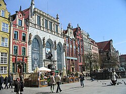
- Gdańsk
- Gębice[5]
- Gniezno[7]
- Gniew
- Gniewkowo[5]
- Golub
- Gostynin[4]
- Goszczyn[4]
- Grabów nad Prosną[6]
- Grójec[4]
- Grudziądz
- Inowłódz[6]
- Inowrocław[5]
- Janowo[4]
- Kalisz[7]
- Kamieńczyk[4]
- Kamion[6]
- Kampinos[4]
- Kcynia[7]
- Kłecko[7]
- Kłodawa[6]
- Kolno[4]
- Koło[7]
- Konin[7]
- Kopanica[3]
- Kościan[3]
- Kościerzyna
- Kowal[5]
- Kowalewo Pomorskie
- Kruszwica[5]
- Latowicz[4]
- Lidzbark
- Lipno[5]
- Liw[4]
- Łasin
- Łęczyca[6]
- Łomża[4]
- Maków Mazowiecki[4]
- Malbork
- Mieścisko[7]
- Międzyrzecz[3]
- Mikstat[6]
- Mława[4]
- Mosina[3]
- Mszczonów[4]
- Nakło nad Notecią[7]
- Nieszawa[5]
- Nowa Brzeźnica[6]
- Nowe
- Nowe Miasto, Płońsk County[4]
- Nowe Miasto Lubawskie
- Nowogród[4]
- Nur[4]
- Oborniki[3]
- Odolanów[7]
- Osieck[4]
- Osmolin[4]
- Ostrołęka[4]
- Ostrów[4]
- Ostrzeszów[6]
- Pajęczno[6]
- Piaseczno[4]
- Piła[3]
- Piotrków[6]
- Płock[4]
- Płońsk[4]
- Pobiedziska[7]
- Podgórz[5]
- Powidz[7]
- Poznań[3]
- Przasnysz[4]
- Przedecz[5]
- Puck
- Pyzdry[7]
- Radomsko[6]
- Radziejów[5]
- Radziłów[4]
- Radzyń
- Rawa[4]
- Rogoźno[3]
- Różan[4]
- Rypin[5]
- Serock[4]
- Sieradz[6]
- Skarszewy
- Skulsk[5]
- Skwierzyna[3]
- Sochaczew[4]
- Sochocin[4]
- Solec[5]
- Stanisławów
- Starogard
- Stawiszyn[7]
- Sulmierzyce[7]
- Szadek[6]
- Szczerców[6]
- Sztum
- Śrem[3]
- Środa[7]
- Świecie
- Tczew
- Tolkmicko
- Toruń
- Tuchola
- Tuszyn[6]
- Ujście[3]
- Wałcz[3]
- Warka[4]
- Warsaw[4]
- Warsaw New Town[4]
- Warta[6]
- Wąsosz[4]
- Wieluń[6]
- Wiskitki[4]
- Wizna[4]
- Wschowa[3]
- Wyszogród[4]
- Zakroczym[4]
- Zambrów[4]
- Zgierz[6]
Lesser Poland Province
Łuck
in the 18th century- Augustów[8]
- Bar (today part of Ukraine)
- Bełz(today part of Ukraine)
- Berezań (today part of Ukraine)
- Będzin
- Bila Tserkva (today part of Ukraine)
- Biecz
- Bielsk[8]
- Bobrovytsia (today part of Ukraine)
- Bohuslav (today part of Ukraine)
- Bracław(today part of Ukraine)
- Brańsk[8]
- Busk (today part of Ukraine)
- Chełm
- Chęciny[9]
- Chmielnik
- Chmielnik (today part of Ukraine)
- Chyhyryn (today part of Ukraine)
- Czerkasy (today part of Ukraine)
- Chervonohorod(today part of Ukraine)
- Częstochowa
- Dobrotvir (today part of Ukraine)
- Drohiczyn[8]
- Dubienka
- Goniądz[8]
- Grabowiec
- Grybów
- Haisyn (today part of Ukraine)
- Horodło
- Yahotyn (today part of Ukraine)
- Yaltushkiv (today part of Ukraine)
- Kamieniec Podolski(today part of Ukraine)
- Kaniv (today part of Ukraine)
- Kazimierz
- Kazimierz Dolny
- Kęty
- Kijów (today part of Ukraine)
- Kleparz
- Kleszczele[8]
- Kłobuck
- Knyszyn[8]
- Korsuń (today part of Ukraine)
- Koszyce
- Kowel(today part of Ukraine)
- Kozienice
- Kraków
- Krasnystaw
- Kremenets (today part of Ukraine)
- Krzepice
- Lanckorona
- Letychiv (today part of Ukraine)
- Lelów
- Leżajsk
- Lityn (today part of Ukraine)
- Lubaczów
- Liubech (today part of Ukraine)
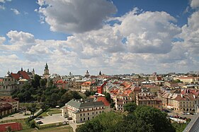
- Lublin
- Liuboml (today part of Ukraine)
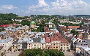
- Lviv (today part of Ukraine)
- Łosice[8]
- Lutsk (today part of Ukraine)
- Łuków
- Małogoszcz[9]
- Mielnik[8]
- Mostyska (today part of Ukraine)
- Mylianovychi (today part of Ukraine)
- Myrhorod (today part of Ukraine)
- Narew[8]
- Nova Ushytsia (today part of Ukraine)
- Nowy Korczyn[9]
- Nowy Sącz
- Nowy Targ
- Olkusz
- Olsztyn
- Opoczno[9]
- Osiek[9]
- Oster (today part of Ukraine)
- Oświęcim
- Ovruch (today part of Ukraine)
- Parczew
- Pereiaslav (today part of Ukraine)
- Pierzchnica[9]
- Pilzno[9]
- Piwniczna
- Podgórze
- Połaniec[9]
- Potelych (today part of Ukraine)
- Płoskirów(today part of Ukraine)
- Proszowice
- Przedbórz[9]
- Przemyśl
- Radom[9]
- Radoszyce[9]
- Rajgród[8]
- Ratne (today part of Ukraine)
- Rohatyn (today part of Ukraine)
- Ropczyce[9]
- Ryczywół[9]
- Sambir (today part of Ukraine)
- Sandomierz[9]
- Sanok
- Shchurovychi (today part of Ukraine)
- Słomniki
- Smotrych (today part of Ukraine)
- Sokal (today part of Ukraine)
- Solec nad Wisłą[9]
- Stebliv (today part of Ukraine)
- Stężyca[9]
- Stopnica[9]
- Stoianiv (today part of Ukraine)
- Staryi Sambir (today part of Ukraine)
- Stryi (today part of Ukraine)
- Suraż[8]
- Svunyukhi (today part of Ukraine)
- Szydłów[9]
- Trakhtemyriv (today part of Ukraine)
- Tykocin[8]
- Tymbark
- Tyszowce
- Ulaniv(today part of Ukraine)
- Urzędów
- Uście Solne
- Velyki Mosty (today part of Ukraine)
- Vinnytsia (today part of Ukraine)
- Volodymyr-Volynskyi(today part of Ukraine)
- Vyshnivka (today part of Ukraine)
- Wąwolnica
- Wieliczka
- Wiślica[9]
- Wolbrom
- Zbuczyn
- Zhydachiv (today part of Ukraine)
- Zhytomyr (today part of Ukraine)
- Zvenyhorodka (today part of Ukraine)
- Zwoleń[9]
Grand Duchy of Lithuania
.jpg)


_(4).jpg)

.jpg)
- Adelsk (today part of Belarus)
- Astryna (today part of Belarus)
- Azarychy (today part of Belarus)
- Azyory (today part of Belarus)
- Berżniki (today part of Poland)
- Babruysk (today part of Belarus)
- Braslaw (today part of Belarus)
- Brest (today part of Belarus)
- Chachersk (today part of Belarus)
- Chavusy (today part of Belarus)
- Cherykaw (today part of Belarus)
- Druskininkai (today part of Lithuania)
- Drysa(today part of Belarus)
- Drysvyaty (today part of Belarus)
- Dyvin(today part of Belarus)
- Dzisna (today part of Belarus)
- Eišiškės (today part of Lithuania)
- Filipów (today part of Poland)
- Gomel (today part of Belarus)
- Grodno (today part of Belarus)
- Haradnaya (today part of Belarus)
- Hieraniony(today part of Belarus)
- Hozha (today part of Belarus)
- Jałówka (today part of Poland)
- Janów (today part of Poland)
- Jeleniewo (today part of Poland)
- Jurbarkas (today part of Lithuania)
- Kalinkavichy (today part of Belarus)
- Kamyenyets (today part of Belarus)
- Kaunas (today part of Lithuania)
- Khotsimsk (today part of Belarus)
- Kletsk (today part of Belarus)
- Klichaw (today part of Belarus)
- Kobryn (today part of Belarus)
- Korycin (today part of Poland)
- Krasnapolle(today part of Belarus)
- Krasnopol (today part of Poland)
- Krynki (today part of Poland)
- Krychaw (today part of Belarus)
- Lahishyn (today part of Belarus)
- Lazdijai (today part of Lithuania)
- Lida (today part of Belarus)
- Lipnishki (today part of Belarus)
- Lunna (today part of Belarus)
- Łomazy (today part of Poland)
- Malyech (today part of Belarus)
- Masty (today part of Belarus)
- Mazyr (today part of Belarus)
- Milejczyce (today part of Poland)
- Minsk (today part of Belarus)
- Mogilev (today part of Belarus)
- Motal (today part of Belarus)
- Mstsibava(today part of Belarus)
- Mstsislaw (today part of Belarus)
- Myadzyel (today part of Belarus)
- Novy Dvor (today part of Belarus)
- Opsa (today part of Belarus)
- Orsha (today part of Belarus)
- Parychy (today part of Belarus)
- Pinsk (today part of Belarus)
- Piszczac (today part of Poland)
- Polotsk (today part of Belarus)
- Porazava (today part of Belarus)
- Prapoysk (today part of Belarus)
- Pruzhany (today part of Belarus)
- Przerośl (today part of Poland)
- Pyerabroddzye (today part of Belarus)
- Pryvalki (today part of Belarus)
- Radashkovichy[10] (today part of Belarus)
- Radun (today part of Belarus)
- Rahachow (today part of Belarus)
- Rechytsa (today part of Belarus)
- Sharashova (today part of Belarus)
- Skidzyel’(today part of Belarus)
- Sokółka (today part of Poland)
- Suchowola (today part of Poland)
- Suraż (today part of Belarus)
- Szczebra (today part of Poland)
- Šventoji (today part of Lithuania)
- Traby (today part of Belarus)
- Trakai (today part of Lithuania)
- Usvyaty (today part of Russia)
- Vasilishki (today part of Belarus)
- Vawkavysk (today part of Belarus)
- Velizh (today part of Russia)
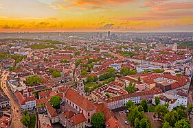
- Vilnias (today part of Lithuania)
- Virbalis (today part of Lithuania)
- Vištytis (today part of Lithuania)
- Vitebsk (today part of Belarus)
- Vladislavovas (today part of Lithuania)
- Voŭpa(today part of Belarus)
- Wasilków (today part of Poland)
- Wiżajny (today part of Poland)
- Wohyń (today part of Poland)
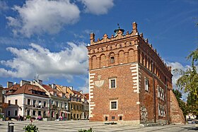
Royal castles and residences
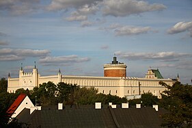
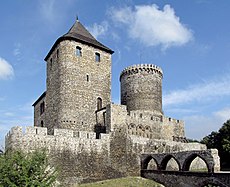
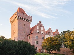
Examples of Polish royal castles and residences found in former royal cities of Poland:
-

-

-
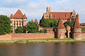 Royal Castle, Malbork (World Heritage Site)
 -
-

-

-
-

-
-

-
 Remainings of the Royal Castle, Nowy Sącz
 -
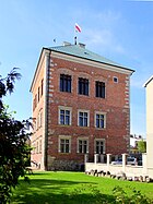
 Remainings of the Royal Castle, Olsztyn
 -
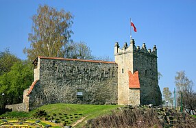
 Remainings of the Royal Castle, Kremenets
 -
-

-


.JPG)


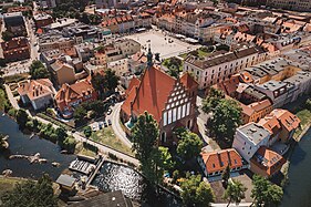
Old towns
Examples of Polish royal cities historic centers include:
-

-
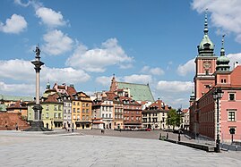 Warsaw Old Town (World Heritage Site)
 -
-
-
-

-
-
-
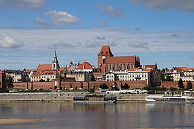
 Bydgoszcz Old Town
 -
 Sandomierz Old Town
 -
 Grudziądz Old Town
 -
 Kazimierz Dolny Old Town


.jpg)
See also
References
- ^ "Miasto królewskie, książęce, biskupie itp. – Słownik języka polskiego PWN".
- ^ Polska encyklopedja szlachecka, Tom I (in Polish). Warszawa: Wydawnictwo Instytutu Kultury Historycznej. 1935. p. 42.
- ^ a b c d e f g h i j k l m n o p q Atlas historyczny Polski. Wielkopolska w drugiej połowie XVI wieku. Część I. Mapy, plany (in Polish). Warszawa: Instytut Historii Polskiej Akademii Nauk. 2017. p. 1a.
- ^ a b c d e f g h i j k l m n o p q r s t u v w x y z aa ab ac ad ae af ag ah ai aj ak al am an ao ap aq ar as at au av Mazowsze w drugiej połowie XVI wieku; Cz.1, Mapy, plany (in Polish). Warszawa: Wydawnictwo Naukowe PWN. pp. 3–4.
- ^ a b c d e f g h i j k l m n o p q r Atlas historyczny Polski. Kujawy i ziemia dobrzyńska w drugiej połowie XVI wieku. Część I. Mapy, plany (in Polish). Warszawa: Instytut Historii Polskiej Akademii Nauk. 2021. p. 1.
- ^ a b c d e f g h i j k l m n o p q r s t u Atlas historyczny Polski. Województwo sieradzkie i województwo łęczyckie w drugiej połowie XVI wieku. Część I. Mapy, plany (in Polish). Warszawa: Instytut Historii Polskiej Akademii Nauk. 1998. pp. 3–4.
- ^ a b c d e f g h i j k l m n o Atlas historyczny Polski. Wielkopolska w drugiej połowie XVI wieku. Część I. Mapy, plany (in Polish). Warszawa: Instytut Historii Polskiej Akademii Nauk. 2017. p. 1b.
- ^ a b c d e f g h i j k l m Atlas historyczny Polski. Województwo podlaskie w drugiej połowie XVI wieku. Część I. Mapy, plany (in Polish). Warszawa: Instytut Historii Polskiej Akademii Nauk. 2021. p. 1.
- ^ a b c d e f g h i j k l m n o p q r s t Województwo sandomierskie w drugiej połowie XVI wieku; Cz.1, Mapy, plany (in Polish). Warszawa: Wydawnictwo Naukowe PWN. 1993. pp. 3–4.
- ^ Słownik geograficzny Królestwa Polskiego i innych krajów słowiańskich, Tom IX (in Polish). Warszawa. 1888. p. 439.
{{cite book}}: CS1 maint: location missing publisher (link)