
Saare County
Saare County
Saaremaa | |
|---|---|
 | |
|
Flag  Coat of arms | |
 | |
| Country | Estonia |
| Capital | Kuressaare |
| Area | |
| • Total | 2,922.19 km2 (1,128.26 sq mi) |
| Population (2022[1]) | |
| • Total | 31,292 |
| • Rank | 9th |
| • Density | 11/km2 (28/sq mi) |
| Ethnicity | |
| • Estonians | 98% |
| • other | 2% |
| GDP | |
| • Total | €518 million (2022) |
| • Per capita | €16,380 (2022) |
| ISO 3166 code | EE-74 |
| Vehicle registration | K |
Saare County (
Municipalities
The county is subdivided into municipalities. There are 3 rural municipalities (Estonian: vallad – parishes) in Saare County.

| Rank | Municipality | Type | Population (2018)[3] |
Area km2[3] |
Density[3] |
|---|---|---|---|---|---|
| 1 | Muhu Parish | Rural | 1,946 | 206 | 9.4 |
| 2 | Ruhnu Parish | Rural | 160 | 12 | 13.3 |
| 3 | Saaremaa Parish | Rural | 31,819 | 2,705 | 11.8 |
Geography
The largest islands of the county are Saaremaa, Muhu, Ruhnu, Abruka and Vilsandi. Arable land is 570 km2 (220 sq mi) and it has a mild maritime climate. The mean annual air temperature is 6.0 °C (42.8 °F) and the mean annual precipitation is 509 mm (20.0 in).
Religion
Religion in Saare County (2021) [1]
| Religion | 2000 | 2011 | 2021 | |||
|---|---|---|---|---|---|---|
| Number | % | Number | % | Number | % | |
| Christianity | 8,645 | 30.2 | 6,606 | 24.6 | 5,230 | 19.7 |
| —Orthodox Christians | 1,960 | 6.8 | 1,309 | 4.8 | 750 | 2.8 |
| — Lutherans |
5,889 | 20.6 | 4,612 | 17.2 | 3,710 | 14.0 |
| — Catholics |
14 | 0.04 | 27 | 0.1 | 60 | 0.2 |
| —Baptists | 400 | 1.4 | 274 | 1.0 | 290 | 1.1 |
| —Jehovah's Witnesses | 43 | 0.1 | 80 | 0.3 | 50 | 0.1 |
| — Pentecostals |
178 | 0.6 | 107 | 0.4 | 80 | 0.3 |
| —Old Believers | 0 | 0.0 | 3 | 0.01 | - | - |
| — Methodists |
128 | 0.4 | 76 | 0.2 | 120 | 0.4 |
| — Adventists |
33 | 0.1 | 34 | 0.1 | 20 | 0.07 |
| —Other Christians | - | - | 84 | 0.3 | 150 | 0.5 |
| Islam | 3 | 0.01 | 9 | 0.03 | - | - |
| Buddhism | - | 16 | 0.06 | 20 | 0.07 | |
| Other religions** | 95 | 0.3 | 183 | 0.6 | 440 | 1.6 |
| No religion | 9,948 | 34.8 | 15,598 | 54.1 | 18,020 | 67.8 |
| Not stated*** | 9,794 | 34.2 | 4,359 | 15,1 | 2,820 | 10.6 |
| Total population* | 28,585 | 26,826 | 26,550 | |||
| *The censuses of Estonia count the religious affiliations of the population older than 15 years of age.[4] ".[4] | ||||||
Ancient Saare county (Oesel)
According to archeological finds, the territory of Saaremaa has been inhabited for at least five thousand years.
In the first centuries AD, political and administrative subdivisions began to emerge in Estonia. Two larger subdivisions appeared: the parish (kihelkond) and the county (maakond). The parish consisted of several villages. Nearly all parishes had at least one fortress. The defense of the local area was directed by the highest official, the parish elder. The county was composed of several parishes, also headed by an elder. By the 13th century, the following major counties had developed in Estonia:
In old Scandinavian sagas, Saaremaa is called Eysysla which means exactly the same as the name of the island in Estonian: the district (land) of island. This is the origin of the island's name in German and Swedish, Ösel, Danish, Øsel, and in Latin Oesel. The name Eysysla appears sometimes together with Adalsysla, 'the big land', perhaps 'Suuremaa' or 'Suur Maa' in Estonian which refers to mainland Estonia. Sagas talk about numerous skirmishes between islanders and Vikings. Saaremaa was the wealthiest county of ancient Estonia and the home of notorious

The Oeselians along with the
Eistland or Esthland is the historical Germanic language name that refers to the country at the eastern shores of the Baltic Sea in general, and is the origin of the modern national name for Estonia. The mainland of modern Estonia in the 8th century Ynglinga saga was called Adalsyssla in contrast to Eysyssel or Ösyssla that was the name of the island (Swedish): Ösel or (Estonian): Saaremaa, the home of the Oeselians (Estonian: Saarlased). In the 11th century, Courland and Estland (Estonia) were both denoted separately by Adam of Bremen.[11]
On the eve of the Northern Crusades, the Oeselians were summarized in the Livonian Rhymed Chronicle thus: "The Oselians, neighbors to the Kurs (Curonians), are surrounded by the sea and never fear strong armies as their strength is in their ships. In summers when they can travel across the sea they oppress the surrounding lands by raiding both Christians and pagans."[12]
Conquest of Saaremaa
In 1206, the Danish army led by king
in Western Estonia. Oeselians attacked the Swedish stronghold the same year, conquered it and killed the entire Swedish garrison including the Bishop of Linköping.In 1222, Valdemar II again tried to conquer Saaremaa, this time establishing a stone fortress housing a strong garrison. But the Danish stronghold was besieged, and surrendered within five days, and the Danish garrison returned to Reval, leaving bishop Albert of Riga's brother Theodoric and few others behind as hostages for peace. The castle was leveled to the ground by the Oeselians.[13]
In 1227, the Livonian Brothers of the Sword, the town of
In 1236, after the defeat of the Livonian Brothers of the Sword in the Battle of Saule, military action on Saaremaa broke out again.
The Oeselians again accepted Christianity by signing treaties with the Master of
In 1261, warfare continued as the Oeselians had once more renounced Christianity and killed all the Germans on the island. A peace treaty was signed after the united forces of the Livonian branch of the Teutonic Order, the Bishopric of Ösel-Wiek, and the forces of
On July 24, 1343, the Oeselians again killed all the Germans on the island, drowned all the clerics and started to besiege the fort at Pöide. After its surrender, the Oeselians levelled the castle and killed all the defenders. In February 1344, Burchard von Dreileben led a campaign over the frozen sea to Saaremaa. The Oeselians' stronghold was conquered and their king Wesse was hanged. In the early spring of 1345, the next campaign of the Livonian branch of the Teutonic Order took place; it ended with a treaty mentioned in the Chronicle of Hermann von Wartberge and the Novgorod First Chronicle. Saaremaa remained the vassal of the master of the Teutonic Order in Livonia, and the Bishopric of Ösel-Wiek.
Gallery
-
 Püha church
 -

-
 Pädaste manor
 -

-

-
 Koigi bog
 -
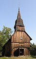 Ruhnu wooden church
 -
 Forest road on Saaremaa
 -
 Historical buildings near the town center of Kuressaare
 -
 Angla windmill
 -
 Saaretuka lighthouse
 -
 Ohessaare cliffs


.jpg)
See also
References
- ^ a b "Population by sex, ethnic nationality and County, 1 January". stat.ee. Statistics Estonia. 1 January 2009. Retrieved 2009-10-18.
- ^ "GROSS DOMESTIC PRODUCT BY COUNTY". stat.ee.
- ^ a b c "Elanike demograafiline jaotus maakonniti". Kohaliku omavalitsuse portaal. Archived from the original on 2019-03-02. Retrieved 2 April 2018.
- ^ a b c Official census data from Statistics Estonia:
- 2000 Census:
- 2011 Census:
- 2021 Census:
- ISBN 0-8179-2852-9.
- ^ (in Norwegian) Olav Trygvassons saga at School of Avaldsnes Archived 2008-06-03 at the Wayback Machine
- ISBN 0-7661-8693-8
- ISBN 0-415-09136-5
- ISBN 0-8122-1714-4
- ISBN 0-231-12889-4
- ^ History of the Archbishops of Hamburg-Bremen By Adam of Bremen Page 196-197
- ISBN 0-929700-10-4
- ISBN 0-929700-10-4
- ^ Liv-, est- und kurländisches Urkundenbuch: Nebst Regesten
External links
- Saare County Government (in Estonian)
Geographic locale | ||||||||||||||||||||||
|---|---|---|---|---|---|---|---|---|---|---|---|---|---|---|---|---|---|---|---|---|---|---|
| ||||||||||||||||||||||
| National | |
|---|---|
| Geographic | |