
Sagaing
Sagaing
စစ်ကိုင်းမြို့ | |
|---|---|
City | |
MST ) |
Sagaing (
Today, with about 70,000 inhabitants, the city is part of Mandalay built-up area with more than 1,022,000 inhabitants estimated in 2011. The city is a frequent tourist destination of day trippers. Within the city are the Sagaing Institute of Education, the Sagaing Education College, Sagaing University, Technological University (Sagaing), and co-operative university (Sagaing).
Sagaing University was established on 11 February 2012. It is in Pakatoe Quarter, Sagaing Township, Sagaing Region, Myanmar. It has an area of 300.35 acres (121.55 ha). As a result, there are now five colleges/university in Sagaing.
Name
The classical name of Sagaing is Zeyapura (ဇေယျာပူရ;
History
Sagaing was the capital of
On 8 August 1988, Sagaing was the site of demonstrations which were concluded by a massacre in which around 300 civilians were killed.[3]
Climate
Located in the rain shadow of the Arakan Mountains, Sagaing has a borderline hot semi-arid climate (Köppen BSh) just short of a tropical savanna climate (Aw). The city receives less than a third as much rainfall as Chittagong at a similar latitude on the Bay of Bengal. Unlike most monsoonal semi-arid climates, the rainy season is relatively long at around five to six months, while variability and extreme monthly and daily rainfalls are much lower than usual with this type of climate.[4]
| Climate data for Sagaing (1991–2020) | |||||||||||||
|---|---|---|---|---|---|---|---|---|---|---|---|---|---|
| Month | Jan | Feb | Mar | Apr | May | Jun | Jul | Aug | Sep | Oct | Nov | Dec | Year |
| Mean daily maximum °C (°F) | 29.5 (85.1) |
32.6 (90.7) |
36.4 (97.5) |
38.3 (100.9) |
36.0 (96.8) |
34.4 (93.9) |
33.7 (92.7) |
33.0 (91.4) |
33.2 (91.8) |
32.8 (91.0) |
31.4 (88.5) |
29.2 (84.6) |
33.4 (92.1) |
| Daily mean °C (°F) | 22.0 (71.6) |
24.5 (76.1) |
28.6 (83.5) |
31.4 (88.5) |
30.9 (87.6) |
30.3 (86.5) |
29.9 (85.8) |
29.5 (85.1) |
29.4 (84.9) |
28.5 (83.3) |
25.9 (78.6) |
22.6 (72.7) |
27.8 (82.0) |
| Mean daily minimum °C (°F) | 14.5 (58.1) |
16.5 (61.7) |
20.8 (69.4) |
24.6 (76.3) |
25.8 (78.4) |
26.2 (79.2) |
26.2 (79.2) |
25.9 (78.6) |
25.5 (77.9) |
24.2 (75.6) |
20.4 (68.7) |
16.0 (60.8) |
22.2 (72.0) |
| Average precipitation mm (inches) | 5.0 (0.20) |
3.5 (0.14) |
5.4 (0.21) |
40.6 (1.60) |
148.6 (5.85) |
82.1 (3.23) |
66.2 (2.61) |
126.2 (4.97) |
158.9 (6.26) |
134.3 (5.29) |
28.4 (1.12) |
4.8 (0.19) |
804.0 (31.65) |
| Average precipitation days (≥ 1.0 mm) | 0.6 | 0.4 | 0.6 | 3.2 | 9.5 | 6.8 | 5.9 | 9.3 | 11.0 | 8.5 | 2.6 | 0.7 | 59.0 |
| Source: World Meteorological Organization[5] | |||||||||||||
People
- Sithu Kyawhtin, King of Ava (1552–1555)
- Ming Dynastyclaimant to China, lived in exile at Sagaing in 1661
- Maurice Collis, author of Trials in Burma, district commissioner of the Sagaing district in 1928
- Mitford Sisters, was killed while serving with the Devonshire Regimentat Sagaing in 1945.
Places of interest
The Kaunghmudaw Pagoda (Burmese: ကောင်းမှုတော် ဘုရား [káʊɴ m̥ṵ dɔ̀ pʰəjá]; Yaza Mani Sula Kaunghmudaw (ရာဇမဏိစူဠာ ကောင်းမှုတော်); Pali: Rājamaṇicūḷā) is a large pagoda on the northwestern outskirts of Sagaing.
Images
-
 Sagaing Hill
 -
 Irrawaddy River from Sagaing Hill, Sagaing
 -
 Pagodas
 -
 Buddhist monks
 -
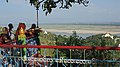 Viewpoint at Sagaing Hill
 -
 Pagodas that dot Sagaing
 -
 U Min Thonze Cave
 -
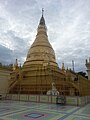 Sone Oo Pone Nya Shin Pagoda, Sagaing Hill
 -
 Umin Thonze Pagoda
 -
 Bridges connecting Sagaing and Mandalay
 -
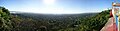 Panoramic view from top of Sagaing Hill


See also
References
- ^ Hardiman, John Percy (1901). Gazetteer of Upper Burma and the Shan States. Superintendent, Government Printing, Burma.
- ISBN 978-0-8248-0368-1.
- ^ Irrawaddy article 1997 Archived 2010-10-04 at the Wayback Machine
- doi:10.3354/cr00856.
- ^ "World Meteorological Organization Climate Normals for 1991–2020". World Meteorological Organization. Retrieved 16 October 2023.
| International | |
|---|---|
| National | |