
Samoan Islands
Native name: Motu o Sāmoa | |
|---|---|
Mauga Silisili | |
| Administration | |
| Largest settlement | Apia (pop. 38,800) |
| Largest settlement | Tafuna (pop. 9,756) |
| Demographics | |
| Population | 249,839 (2012) |
The Samoan Islands (
The population of the Samoan Islands is approximately 250,000.
The oldest known evidence of human activity in the Samoan Islands dates to around 1050 BCE. It comes from a
Samoa and American Samoa

Politically, the Samoan Islands are divided into two jurisdictions:[1]
- Western Samoauntil 1997.
- Capital: Samoan tala.
- Capital:
- American Samoa, an unincorporated territory of the United States comprising the eastern half of the Samoa Islands. (199 km2 (77 sq mi) and 49,710 inhabitants (2020)).
- Capital: US dollar.
- Capital:
Political partition
In the late 19th century, competition for political control of the islands between the
Islands
The Samoan Islands has total of 18 islands spread 3,030 km2 (1,170 sq mi) in a west to east direction.[9][10][11]
Samoa

This section needs additional citations for verification. (July 2022) |
- Mt Matavanu (1905–1911); Mata o le Afi (1902); Mauga Afi(approximately 1725).
- Manono: population 889 (2006).
- Nuʻulopa: uninhabited; lies in the Apolima Strait between Upolu and Savaiʻi.
- Apolima: population 75 (2006).
- Upolu: population 143,418 (2011); the most populous island in the group.
- Nuʻusafeʻe: uninhabited; tiny rocky islet off the south coast of Upolu, near the village of Poutasi.
- Nuʻutele: uninhabited; volcanic tuff ring; conservation for native birds; can also be seen from the popular Lalomanu Beach.
- Nuʻulua: uninhabited; volcanic tuff ring; land area 25 hectares (62 acres); conservation habitat for endemic native birds.[13]
- Namua: uninhabited
- tuff ring.
The islands of Manono, Apolima and Nuʻulopa lie in the Apolima Strait between Upolu and Savaiʻi. The four small, uninhabited islands - Nuʻutele, Nuʻulua, Namua and Fanuatapu - are situated off the east coast of Upolu and comprise the Aleipata Islands.[10]

American Samoa
- Tutuila: population 48,405 (per 2020 census); main island in the territory.
- Pola Island: unpopulated; part of the National Park of American Samoa.
- Aunu'u: population 473 (per 2020 census); located southeast of Tutuila.
- Swains Island: unpopulated (per 2020 census); politically administered by American Samoa, but culturally part of Tokelau; copra plantation.
- Ofu‑Olosega: volcanic doublet encompassing Ofu (population 132, per 2020 census) and Olosega (population 147, per 2020 census); in the Manu'a Group of islands.
- Manu'a Group
- hawksbill turtle.
Location
The islands are approximately 800 km (500 mi) from Fiji, 530 km (330 mi) from Tonga, 2,900 km (1,800 mi) from New Zealand, and 4,000 km (2,500 mi) from Hawaii, U.S.[10]
The islands lie between 13° and 14° south latitude and 169° and 173° west longitude, and span an area of about 480 km (300 mi) from west to east.[10]
The larger islands are
Highest points
The highest point in Samoa is Mt.
Landmass
The next largest island is Tutuila, where the city and harbor of Pago Pago (with a population of 3,519 in 1990) is located. Tutuila is much smaller than Upolu and Savai‘i, at 136.2 km2 (52.6 sq mi) in area, but it is the largest island in American Samoa.[11] The highest point on Tutuila is Matafao Peak.[19]
Smaller islands in the archipelago include the three islets (
Time zone
In 1892, the Samoan islands shifted to the eastern side of the
By 2011, the government of independent Samoa decided to shift back to the western side in order to have the same day as Australia and New Zealand. Being one day behind these countries, Samoa's primary trading partners, left only four business days in a week. The shift was implemented by skipping Friday, December 30; workers were paid for this "missed" day. Neighboring Tokelau shifted as well on this day.[22]
Geology
-1.svg)
The
2009 Samoa earthquake and tsunami

The
Vailulu'u Seamount
The
Climate
The Samoan climate is tropical, with a rainy season from November to April. The island group is frequently hit by tropical cyclones between December and March, due to its position in the South Pacific Ocean.[29]
Gallery
- Samoa Islands
-
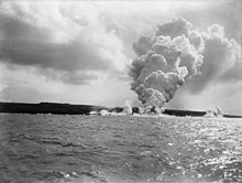 Savai'iisland, 1905
 -
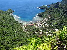 Afono village, Tutuilaisland, American Samoa.
 -
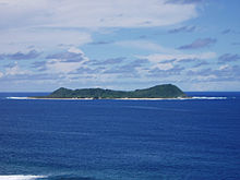 Aunu'uisland, offshore of the island of Tutuila, American Samoa
 -
 A beach on Ofu-Olosega, a volcanic doublet in the Manu'a Group of islands.
 -
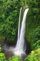 Fuipisia waterfall in Lotofaga, Upolu island.


See also
- Archaeology of Samoa
- Architecture of Samoa
- Coming of Age in Samoa
- First Samoan Civil War
- Geography of Samoa
- Samoan culture
- Samoan language
- Samoans
- Second Samoan Civil War
- Siege of Apia
- Tokelauan language (belongs to the group of Samoic languages, and is derived from Samoan)
- Tuvaluan language (belongs to the group of Samoic languages, and is closely related to Samoan)
- Samoan unification
References
- ^ a b "Cultures of Polynesia - Polynesian Cultural Center". polynesia.com. Retrieved 2 April 2018.
- ISBN 982-02-0012-1. Retrieved 17 April 2010.
- ISBN 1-56691-411-6. Retrieved 20 June 2010.
Samoans full blooded Polynesian percentage.
- ^ "New Information for the Ferry Berth Site, Mulifanua, Western Samoa by Roger C. Green & Helen M. Leach". Journal of the Polynesian Society. 98 (3): 1989. Retrieved 22 April 2010.
- ^ Masterman, Sylvia (1934). The Origins of International Rivalry in Samoa: 1845–1884. George Allen and Unwin Ltd, London. p. 14.
- ^ Ryden, George Herbert. The Foreign Policy of the United States in Relation to Samoa. New York: Octagon Books, 1975. (Reprint by special arrangement with Yale University Press. Originally published at New Haven: Yale University Press, 1928), p. 574. The Tripartite Convention (United States, Germany, Great Britain) was signed at Washington on December 2, 1899, with ratifications exchanged on February 16, 1900.
- ^ date of ratification by the League of Nations was 10 January 1920; Class C mandates were designed for populations considered incapable of self-government
- ^ "The rise of the Mau movement". NZ History online. Retrieved 30 June 2010.
- ^ a b "Demographic Yearbook—Table 3: Population by sex, rate of population increase, surface area and density" (PDF). United Nations Statistics Division. 2010.
- ^ a b c d e Robert, Kiste (1993–2002). Samoa: Microsoft Encarta Reference Library 2003. Redmond, WA: Microsoft Corporation. 60210-442-1635445-74407.
- ^ a b c American Samoa, World Atlas: Microsoft Encarta Reference Library 2003. Redmond, WA: Microsoft Corporation. 1993–2002. 60210-442-1635445-74407.
- ^ "Census 2016 Preliminary count" (PDF). Samoa Bureau of Statistics. Retrieved 6 July 2022.
- ^ "issg Database: Distribution Details for Rattus exulans".
- ^ "Insular Area Summary for American Samoa". U.S. Department of the Interior. April 6, 2010. Archived from the original on October 9, 2009. Retrieved April 11, 2011.
- ^ "Background: Volcanic Islands and Seamounts in the Samoan Region". NOAA Office of Ocean Exploration and Research. Retrieved 3 July 2022.
- ISBN 0-691-02399-9.
- ISBN 978-1573062992.
- ^ Craig, P. (ed.). "Natural History Guide to American Samoa" (PDF). National Park of American Samoa, Department Marine and Wildlife Resources, American Samoa Community College. Retrieved 16 August 2009.
- ^ "Matafao Peak, AS". National Park Service. Retrieved 3 July 2022.
- ^ "Samoa an Overview". donbosco.asn.au. Archived from the original on 2007-11-20. Retrieved 2007-11-26.
- ^ "Going Back 24 Hours". Evening News. 1892-07-20. Retrieved 2022-07-03 – via NLA.
- ^ ISSN 0362-4331. Retrieved 2022-07-03.
- ^ Lippsett, Laurence (3 September 2009). "Voyage to Vailulu'u". Woods Hole Oceanographic Institution. Retrieved 19 April 2010.
- Bibcode:2006AGUFM.V34B..02K.
- ^ "Magnitude 8.1 – SAMOA ISLANDS REGION". earthquake.usgs.gov. 2009-09-29. Archived from the original on 7 October 2009. Retrieved 22 April 2010.
- ^ "National Earthquake Information Center (NEIC)". Neic.usgs.gov. Archived from the original on 2012-03-19. Retrieved 2015-10-01.
- .
- PMID 16614067.
- ^ "Samoa: Climate". Encyclopædia Britannica. Retrieved 2007-11-26.
External links
- Samoa.travel: Samoa Tourism Authority website
- The American Cyclopædia.
- . Encyclopædia Britannica. Vol. XVII (9th ed.). 1884.
 Media related to Samoa Islands at Wikimedia Commons

| International | |
|---|---|
| National | |
| Other | |