
San Antonio Springs
| San Antonio Springs | |
|---|---|
 Location of San Antonio Springs | |
 | |
| Location | San Antonio, Texas, USA |
| Coordinates | 29°28′08″N 98°28′03″W / 29.468889°N 98.467500°W |
| Spring source | Edwards Aquifer |
| Elevation | 680 feet (210 m) above sea level |
| Type | Karst springs |
| Provides water for | San Antonio River |
| Magnitude | 2 |
| Discharge | 20 cubic feet (570 L)/s |
San Antonio Springs (also known as the Blue Hole) is a cluster of
.Geography
The San Antonio Springs are located about three miles (5 km) north of Downtown San Antonio; most are now on the property of the
faults along the Balcones Escarpment. There have been more than 100 individual springs identified, but many of these are no longer active due to pumping demands on the Edwards Aquifer and sedimentation from the upstream Olmos Creek, although sedimentation has been partially mitigated by the Olmos Dam since 1926.[1] During periods of drought
, the springs sometimes stop flowing entirely, only to resume when water levels rise in the aquifer. The mean flow from the springs is 20 ft³/s (0.6 m³/s).
History
Artifacts from
Paleo-Indian cultures have been found at the site of the San Antonio Springs; some of these artifacts are more than 11,000 years old.[2]
The earliest
By the
artesian wells were drilled to provide clean water for the city.[3]
Gallery
-
 Entrance to the springs area
 -
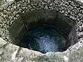
 The largest spring, The Blue Hole
 -
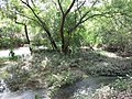
 High water levels due to recent rains
 -
 Spring water pouring out of the mouth of The Blue Hole
 -
 Water flows downstream
 -
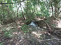
 Additional, smaller springs
 -
 More springs
 -
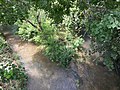 Olmos Creek (left) joins with San Antonio Springs (right) to form the San Antonio River


References
- ISBN 978-1-58544-196-9. Retrieved 2021-11-08.
- ^ a b "San Antonio Springs". Texas State Historical Association, Handbook of Texas. 1995-04-01. Retrieved 2021-11-08.
- ^ a b c "San Antonio Springs and Brackenridge Park". The Edwards Aquifer Website. Retrieved 2021-11-08.
External links
- Information from EdwardsAquifer.net
- South Central Texas Regional Water Plan
- San Antonio Springs from the Handbook of Texas Online