
San Luis Rey River
| San Luis Rey River | |
|---|---|
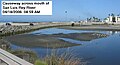
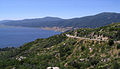
 River mouth from North Coast Hwy bridge. | |
| Location | |
| Country | United States |
| State | California |
| Physical characteristics | |
| Source | Lake Henshaw reservoir |
| • location | Confluence of West Fork San Luis Rey River and Buena Vista Creek, Cleveland National Forest, San Diego County |
| • coordinates | 33°24′02″N 116°37′26″W / 33.40056°N 116.62389°W[1] |
| • elevation | 2,627 ft (801 m) |
| Mouth | Pacific Ocean |
• location | Oceanside, San Diego County |
• coordinates | 33°12′08″N 117°23′32″W / 33.20222°N 117.39222°W[1] |
• elevation | 0 ft (0 m) |
| Length | 69 mi (111 km), East-west[2] |
| Basin size | 557 sq mi (1,440 km2)[3] |
| Discharge | |
| • location | Oceanside[3] |
| • average | 36.3 cu ft/s (1.03 m3/s)[3] |
| • minimum | 0 cu ft/s (0 m3/s) |
| • maximum | 25,700 cu ft/s (730 m3/s) |
| Basin features | |
| Tributaries | |
| • left | Buena Vista Creek |
| • right | West Fork San Luis Rey River, Pauma Creek |
The San Luis Rey River is a river in northern San Diego County, California.
The river's headwaters are in the
The river is over 69 miles (111 km) long[4] and drains 562 square miles (1,460 km2). There is little water in the river during most of the year, but it can have very large flows during winter storms.
Course
The San Luis Rey River rises in two main branches. The mainstem starts east of Rocky Mountain in the Cleveland National Forest and flows generally south-southwest. The West Fork's headwaters rise as a pair of tiny streams, Fry Creek and Iron Springs Creek, just to the north of Palomar Mountain. These two streams combine into the West Fork, which flows southeast through the Mendenhall Valley. The West Fork joins the main stem at Lake Henshaw, a reservoir formed by a dam across the main stem San Luis Rey River.
From the base of Henshaw Dam, the river winds west along the foot of the Palomars, followed by
After passing Bonsall the river flows generally southwest, through the city of Oceanside. Although usually dry up to this point the river starts to contain water as it nears the mouth, both from seeps and from tidal activity that forms a lagoon at the mouth of the river. The San Luis Rey empties into the Pacific north of Oceanside, about 2 miles (3.2 km) south of the Santa Margarita River and about 30 miles (48 km) north of San Diego.
Water resources
The dam that forms
Urbanization, mining, and agriculture have caused substantial deterioration of water quality in the drainage basin. Since Lake Henshaw is relatively close to the headwaters, it is a source of drinking water. However, the water in the lower reaches of the river is used for groundwater recharge only. A bridge was completed across the river near its mouth in 2009, replacing a small causeway that washed away in storms.
History
The river was within the homeland of the
The first European land exploration of
In popular culture
The 2010 Rockstar Games release "Red Dead Redemption" features a river inspired by the San Luis Rey. The "San Luis River" serves as the border between the Western Border States and Mexico and is one of the hallmarks of the game.
Gallery
-
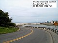 Pacific St and mouth of river
 -
 Former causeway across mouth of river
 -
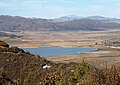 Lake Henshaw from Mesa Grande Rd
 -
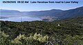 Lake Henshaw from road to Love Valley
 -
 Lake Henshaw from lookout on County Highway S7
 -
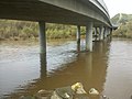 Underneath the Benet Rd bridge after several days of intense rainfall in winter 2010
 -
 Underneath the Benet Rd bridge as seen most of the year


References
- ^ a b "San Luis Rey River". Geographic Names Information System. United States Geological Survey, United States Department of the Interior. 1981-01-19. Retrieved 2010-09-12.
- ^ Length measured in Google Earth using path measure tool; measured to longest source (includes Fry Creek and West Fork San Luis Rey River
- ^ a b c "Water-Data Report 2009: USGS Gage #11042000 on the San Luis Rey River at Oceanside, CA" (PDF). National Water Information System. U.S. Geological Survey. 1930–2009. Retrieved 2010-09-12.
- ^ U.S. Geological Survey. National Hydrography Dataset high-resolution flowline data. The National Map, accessed March 16, 2011
- ^ Bolton, Herbert E. (1927). Fray Juan Crespi: Missionary Explorer on the Pacific Coast, 1769-1774. HathiTrust Digital Library. pp. 129–132, 271–272. Retrieved May 5, 2014.
| International | |
|---|---|
| National | |
| Other | |