
San Pedro Sula
San Pedro Sula | |
|---|---|
City and municipality | |
 Historic and modern landmarks of San Pedro Sula | |
|
UTC−6 (Central America) |
San Pedro Sula (Spanish pronunciation: [sam ˈpeðɾo ˈsula]) is the capital of Cortés Department, Honduras. It is located in the northwest corner of the country in the Sula Valley, about 50 kilometers (31 miles) south of Puerto Cortés on the Caribbean Sea. With a population of 701,200 in the central urban area (2023 calculation)[5] and a population of 1,445,598 in its metropolitan area in 2023, it is the nation's primary industrial center and second largest city after the capital Tegucigalpa, and the largest city in Central America that is not a capital city.
History
Before the arrival of the Spanish, the
On 27 June 1536, Don Pedro de Alvarado founded a Spanish town beside the Indian settlement of Choloma, with the name of Villa de Señor San Pedro de Puerto Caballos (modern San Pedro Sula). The new town had 35 Spanish citizens, and Alvarado allocated 200 of his slaves to help build the new town and work the surrounding fields. He sent out expeditions into outlying regions to secure the new town, extend the area of Spanish domination, and commandeer supplies. Alvarado annulled all encomienda rights established in the area under Andres de Cerezeda, and reassigned the villages to the citizens of San Pedro.
The new settlement barely survived the colonial period. In 1601, the Spanish government declared Santo Tomás as the official port for the Central American colonies; this move diverted exports from Puerto Cortés and resulted in an economic decline that would last through the 17th century. Additionally, San Pedro Sula was left exposed to raids by pirates and French, Dutch, and English mercenaries. By the mid-18th century, the Spanish government decided to build a number of coastal fortresses to curb English attacks. One of these fortresses, the Fortaleza de San Fernando, was built in Omoa, less than 50 miles from San Pedro Sula. The subsequent increase in trade supported an increase in population from 70 inhabitants in 1714 to 357 in 1789.[7]
Post-
-
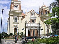 San Pedro Sula Cathedral
 -
 Panoramic view of Downtown San Pedro Sula
 -
 Municipal Palace


Economy
In 2013, fifteen years after the effects of Hurricane Mitch, Honduras is one of the poorest countries in Latin America; around San Pedro Sula, banana production has not fully recovered, and "manufacturing has all but dried up."[9] The problems are exacerbated by organized gangs, whose rules prevent residents from safely leaving gang-controlled neighborhoods such as Chamelecón for jobs in other parts of town.[9]
In 2000, then-Mayor Roberto Larios Silva said "San Pedro Sula is where the economic development of the country is concentrated via the city's industrial, commercial, and financial development." The then-manager of Hotel Copantl attributed its growth in business-related tourism ...[to] the
As of 2011[update], San Pedro Sula generated two-thirds of the country's gross domestic product (GDP).[11]

Crime
San Pedro Sula was the "
According to the
Crime and economic stress have led to the migration of large numbers of unaccompanied minors to the US border. The latest data from the CBP shows San Pedro Sula as the major source for Unaccompanied Alien Children (UAC) migrating from Honduras.
Geography
Climate
San Pedro Sula features has a
| Climate data for San Pedro Sula, Honduras ( La Mesa International Airport ) 1961–1990, extremes 1944–present
| |||||||||||||
|---|---|---|---|---|---|---|---|---|---|---|---|---|---|
| Month | Jan | Feb | Mar | Apr | May | Jun | Jul | Aug | Sep | Oct | Nov | Dec | Year |
| Record high °C (°F) | 37.2 (99.0) |
39.5 (103.1) |
42.8 (109.0) |
42.0 (107.6) |
42.0 (107.6) |
41.1 (106.0) |
38.0 (100.4) |
38.8 (101.8) |
39.2 (102.6) |
37.8 (100.0) |
37.5 (99.5) |
37.0 (98.6) |
42.8 (109.0) |
| Mean daily maximum °C (°F) | 29.2 (84.6) |
30.4 (86.7) |
33.0 (91.4) |
34.0 (93.2) |
35.2 (95.4) |
34.3 (93.7) |
33.3 (91.9) |
33.4 (92.1) |
33.5 (92.3) |
31.6 (88.9) |
30.2 (86.4) |
29.2 (84.6) |
32.3 (90.1) |
| Daily mean °C (°F) | 23.5 (74.3) |
24.1 (75.4) |
25.8 (78.4) |
27.1 (80.8) |
28.1 (82.6) |
27.7 (81.9) |
27.1 (80.8) |
27.3 (81.1) |
27.2 (81.0) |
26.0 (78.8) |
24.7 (76.5) |
23.7 (74.7) |
26.0 (78.8) |
| Mean daily minimum °C (°F) | 19.8 (67.6) |
20.0 (68.0) |
21.4 (70.5) |
22.5 (72.5) |
23.8 (74.8) |
23.8 (74.8) |
23.2 (73.8) |
23.3 (73.9) |
23.3 (73.9) |
22.5 (72.5) |
21.4 (70.5) |
20.4 (68.7) |
22.1 (71.8) |
| Record low °C (°F) | 12.8 (55.0) |
10.0 (50.0) |
13.4 (56.1) |
15.0 (59.0) |
20.2 (68.4) |
17.0 (62.6) |
18.9 (66.0) |
18.9 (66.0) |
18.9 (66.0) |
13.9 (57.0) |
15.0 (59.0) |
12.8 (55.0) |
10.0 (50.0) |
| Average precipitation mm (inches) | 72.0 (2.83) |
59.6 (2.35) |
32.0 (1.26) |
32.1 (1.26) |
62.9 (2.48) |
142.4 (5.61) |
110.2 (4.34) |
105.7 (4.16) |
151.7 (5.97) |
147.8 (5.82) |
135.3 (5.33) |
121.7 (4.79) |
1,173.4 (46.20) |
| Average precipitation days (≥ 1.0 mm) | 6 | 5 | 3 | 4 | 4 | 10 | 10 | 10 | 10 | 10 | 9 | 8 | 89 |
| Average relative humidity (%)
|
84 | 81 | 77 | 75 | 74 | 76 | 79 | 79 | 79 | 81 | 83 | 85 | 80 |
| Mean monthly sunshine hours | 186.0 | 178.0 | 238.7 | 222.0 | 220.1 | 201.0 | 210.8 | 198.4 | 183.0 | 198.4 | 156.0 | 155.0 | 2,347.4 |
| Mean daily sunshine hours | 6.0 | 6.3 | 7.7 | 7.4 | 7.1 | 6.7 | 6.8 | 6.4 | 6.1 | 6.4 | 5.2 | 5.0 | 6.4 |
| Source 1: NOAA[20]
| |||||||||||||
| Source 2: Deutscher Wetterdienst (sun and humidity),[21] Meteo Climat (record highs and lows)[22] | |||||||||||||
Administrative divisions

San Pedro Sula, as most cities built under the Spanish colonial period,[citation needed] is divided in quadrants. Avenues in the city run from north to south and streets run from east to west. First Street and First Avenue mark the "center of the city" and effectively divide it into four major quadrants NW, NE, SW and SE.[23]
Southwest
Barrio El Benque, the business district, is just to the west and south of the center, and other neighborhoods in the suroeste include Barrio Paz Barahona, Barrio La Guardia, Colonia Altamira, Colonia Mesetas, Barrio Río de Piedras, Barrio Suyapa (from 12 Avenida S out to Avenida Circunvalación, from 7 Calle S to 10 Calles S), Colonia Hernandez, Barrio Prado Alto, and Colonia El Chamelecón. The latter includes area from 23 Avenida S west to 27 Avenida S, from 1 Calle (named Bulevar Los Próceres there) south to 5 Calle S0. To the south of Colonia El Chamelecón are Colonia Dubón, Colonia Figueroa, Colonia Trejo (from 10 Calle S to 12 Calle S, from about Avenida Circunvalación to 25 Avenida S, including the Consulate of Nicaragua), Colonia Altamira, and Colonia Altiplano. Colonia Las Mesetas runs from 12 Calle S to 14 Calle S, from 21 Avenida A (S) to past 24 Avenida S.[24]
Northwest
Barrio Guamilito is just to the west and north of the center. Noroeste neighborhoods include Colonia Moderna (from 1 Calle to 5 Calle NO, from Avendia Circunvalación to the river beyond 24 Avenida), Colonia La Mora (from 5 Calle NO to 7 Calle NO, from Avendia Circunvalación to the río beyond 24 Avenida), Colonia Zeron, the Colonia Columbia by the
From the river past 24 Avenida, north to 25 Calle and west to 12 Avenida, is Colonia Universidad.
Just past the Universidad Nacional Autónoma de Honduras en el Valle de Sula, and spanning the Río Bermejo, is Colonia El Pedregal, which has residential high-rises.[24]
Further out, north across the Río Bermejo, running to the edge of the city, and with calles (streets) renumbering from 1 up, are Colonia Los Alpes and Rancho El Coco and Residencial Los Cedros and Colonia La Tara.[24]
Far to the north is Colonia Fesitranh.[24]
Northeast
Barrio Las Acacias is just to the north of center. Nor-Este neighborhoods include Barrio San Cristobal, Villa Florencia, Colonia Ideal, Barrio Morazán, Colonia Modelo, and further out Colonia Bográn, Colonia El Carmen, and Colonia Los Laureles.[24]
Southeast
Includes the road to the airport,
Chamelecón
With dateline giving San Pedro Sula as the location, the
Various
- Colonia Tara
- Colonia Jardines del valle
- Residencial Etahsa
- Residencial El Bordo
- Colonia Bellavista
- Colonia Cemcol
- Barrio el Guamilito
- Colonia El Roble
- Colonia Juan Lindo
- Colonia La Moderna
- Colonia Las Torres
- Colonia López Arellano
- Colonia Victoria
- Colonia Montefresco
- Barrio Santa Anita
- Barrio El Centro
- Colonia Las Mercedes
- Colonia Los Álamos
- Colonia La Veranda
- Colonia Los Cedros
- Colonia Los Cedritos
- Colonia Rodas Alvarado
- Barrio Barandillas
- Barrio Santa Ana
- Barrio Los Andes
- Barrio Concepción
- Barrio Suncery
- Residencial Los Álamos
- Residencial Juan Ramón Molina
- Colonia Villas del Carmen
- Residencial Villas Paraíso
- Villas Mackay
- Villas Matilda
- La Foresta
- Los Castaños
- Villas del Campo
- Merendon Hills
- Residencial Casa Maya
- Residencial Casa Maya 2
- Residencial Casa Maya 3
- Residencial Casa Maya 4
- Residencial Hebrón
- Residencial Canaán
- Residencial Fontana de la Arboleda
- Residencial Tribeca
- Colonia San José de Sula
- Colonia San Carlos de Sula
- Colonia Satélite
- Colonia Felipe Zelaya
- Colonia FESITRANH
- Colonia El Periodista
- Colonia Del Valle
- Colonia La Veranda
- Colonia COLVISULA
Sports

The Villa Olímpica is a multi-sporting complex that has facilities for most Olympic style games including football, boxing, swimming, baseball, cycling, and multipurpose gymnasiums. [citation needed]
San Pedro Sula is the only city in the country that houses to two football stadiums. The
As of 2009[update], San Pedro Sula has been the home venue for Honduras national football team matches.[26]
Education
San Pedro Sula is home to several universities, including:
- Universidad Catolica de Honduras
- Universidad de San Pedro Sula
- Universidad Pedagogica Nacional Francisco Morazan
- Instituto Tecnologico Sampedrano
- Universidad Tecnologica de Honduras (UTH)
- Universidad Tecnologica Centroamericana (UNITEC)
- Instituto Tecnico de Electricidad y Electronica (ITEE)
Tourism

Cathedral
It has a Roman Catholic Cathedral that was built in 1949.[27] as well as a Greek Orthodox cathedral, Iglesia Ortodoxa de Antioquía San Juan Bautista, built in 1963.
Currusté
This archeological site is two kilometers along the street that goes to
See also
References
- ^ "Distrito central: Informacion del municipio". XVII Censo de Población y VI de Vivienda 2013. Retrieved 30 July 2016.
- ^ World Population Review Population of Cities in Honduras (2020)
- ^ Citypopulation.de Population of departments and municipalities in Honduras
- ^ "TelluBase—Honduras Fact Sheet (Tellusant Public Service Series)" (PDF). Retrieved 11 January 2024.
- ^ Citypopulation.de Population of the major cities in Honduras
- ^ Euraque, Darío. El capitalismo de San Pedro Sula y la historia política hondureña (1870–1972). Editorial Guaymuras, 2001.
- ^ The Cost of Conquest: Indian Decline in Honduras Under Spanish Rule. By Newson, Linda. Boulder: Westview Press, 1986. Pp. 375. Paper.
- ^ Dario Euraque, Reinterperting the Banana Republic: Region and State in Honduras, 1870–1972 (Chapel Hill, North Carolina: University of North Carolina Press, 1996) pp. 25–27.
- ^ a b c d e Wilkinson, Tracy. "In Honduras, rival gangs keep a death grip on San Pedro Sula". Los Angeles Times. Retrieved 17 December 2013.
- ^ "San Pedro Sula becomes popular convention destination". Special International Report. The Washington Times Advertising Department. 24 March 2000. Archived from the original on 23 August 2001. Retrieved 17 December 2013.
- ^ "Honduras's indebted economy: The cost of a coup". The Economist. 399 (8737). The Economist Newspaper Limited: 71. 11–17 June 2011. Retrieved 17 December 2013.
The country of 8m is fighting back hard against its "unjust strangulation by the rest of the world", says Luis Larach, head of the chamber of commerce in San Pedro Sula, a northern export powerhouse that generates two-thirds of the country's GDP.
- ^ "Most Dangerous Cities in the World". worldatlas. 2 March 2016. Retrieved 8 May 2016.
- ^ Sterbenz, Christina (31 December 2014). "San Pedro Sula, Honduras is the world's most violent place". Business Insider. Retrieved 31 December 2014.
- ^ a b Romo, Rafael; Thompson, Nick (28 March 2013). "Inside San Pedro Sula, the 'murder capital' of the world". CNN. Retrieved 30 April 2013.
- ^ a b Miroff, Nick (13 January 2012). "San Pedro Sula, Honduras is the world's most violent place". The Washington Post. Retrieved 30 April 2013.
- ^ Romo, Rafael (28 March 2013). "Inside San Pedro Sula, 'murder capital of the world". CNN.com.
- ^ "Honduran City is World Murder Capital; Juarez Drops for Second Year in a Row". Fox News Latino. 8 February 2013. Retrieved 30 April 2013.
- ^ Miroff, Nick (8 March 2012). "Grim toll as cocaine trade expands in Honduras". The Washington Post.
- ^ Cabrera, Jorge (5 April 2013). "Life and death in the murder capital". Reuters. Archived from the original on 8 April 2013. Retrieved 30 April 2013.
- ^ "La Mesa Climate Normals 1961–1990". National Oceanic and Atmospheric Administration. Retrieved 24 January 2016.
- ^ "Klimatafel von San Pedro Sula (La Mesa), Bez.Cortés / Honduras" (PDF). Baseline climate means (1961–1990) from stations all over the world (in German). Deutscher Wetterdienst. Retrieved 24 January 2016.
- ^ "Station La Mesa" (in French). Meteo Climat. Retrieved 12 June 2016.
- ISBN 9781588436023. Retrieved 1 July 2012.
- ^ a b c d e f g h Google Maps
- New York Times.
- ^ "El año 2009 será duro" [The year 2009 will be hard]. Diario La Prensa (in Spanish). Archived from the original on 12 December 2008.
- ^ "Introducing San Pedro Sula". Lonely Planet. Retrieved 9 April 2015.
- ^ "Parque arqueologico Curruste desaparecer nuevo". Retrieved 22 September 2019.
External links
 San Pedro Sula travel guide from Wikivoyage
- Honduras Weekly
- Universidad de San Pedro Sula
Capital: San Pedro Sula | ||
| Municipalities |  | |
| International | |
|---|---|
| National | |
| Geographic | |
| Other | |