
San Pedro de Atacama
San Pedro de Atacama | |
|---|---|
 San Pedro de Atacama at the edge of the Salar de Atacama | |
|
| |
| Area code | (+56) 5 |
| Website | Municipalidad San Pedro de Atacama |


San Pedro de Atacama is a
History
San Pedro de Atacama grew, over centuries, around an
It was part of Bolivia since independence from Spain until Chile claimed ownership during the War of the Pacific. During that war, the Battle of Río Grande was fought in the surroundings.
Demographics
According to the 2002 census of the National Statistics Institute, San Pedro de Atacama had 4,969 inhabitants (2,928 males and 2,041 females). Of these, 1,938 (39%) lived in urban areas and 3,031 (61%) in rural areas. The population grew by 75.6% (2,140 persons) between the 1992 and 2002 censuses.[1]
Administration
As a commune, San Pedro de Atacama is a third-level
Within the
Climate
The town lies at an average of 8,000 feet (2,400 m), thus visitors often experience mild altitude sickness such as dizziness, lethargy and headaches.[4] The local climate is extremely dry and mild, with daytime temperatures between 25–30 degrees Celsius (77–86 degrees Fahrenheit) in the summer (December to February) and 18–25 °C (64–77 °F) in the winter (June to August). Nighttime temperatures routinely drop below 0 °C (32 °F) and can reach as low as −10 °C (14 °F) in the winter. The record high temperature of 38.3 °C (100.9 °F) was registered on January, 2024 in San Pedro de Atacama.[5]
| Climate data for San Pedro de Atacama | |||||||||||||
|---|---|---|---|---|---|---|---|---|---|---|---|---|---|
| Month | Jan | Feb | Mar | Apr | May | Jun | Jul | Aug | Sep | Oct | Nov | Dec | Year |
| Mean daily maximum °C (°F) | 28.0 (82.4) |
28.0 (82.4) |
27.0 (80.6) |
25.0 (77.0) |
21.8 (71.2) |
18.9 (66.0) |
19.3 (66.7) |
21.5 (70.7) |
23.4 (74.1) |
25.7 (78.3) |
27.3 (81.1) |
28.0 (82.4) |
24.5 (76.1) |
| Mean daily minimum °C (°F) | 8.8 (47.8) |
9.4 (48.9) |
7.9 (46.2) |
5.1 (41.2) |
1.9 (35.4) |
−0.5 (31.1) |
−0.8 (30.6) |
0.9 (33.6) |
2.7 (36.9) |
4.4 (39.9) |
5.8 (42.4) |
7.3 (45.1) |
4.4 (39.9) |
| Average precipitation mm (inches) | 4 (0.2) |
21 (0.8) |
7 (0.3) |
0 (0) |
1 (0.0) |
2 (0.1) |
0 (0) |
1 (0.0) |
1 (0.0) |
0 (0) |
1 (0.0) |
0 (0) |
38 (1.5) |
| Average relative humidity (%)
|
28 | 38 | 31 | 23 | 22 | 20 | 18 | 14 | 13 | 13 | 17 | 22 | 22 |
| Source: Atlas Agroclimatico de Chile (temperatures 1958–1989, precipitation 1960–2015, humidity 2011–2015)[7] | |||||||||||||
Transportation
San Pedro lies on the main paved road from
Tourism
San Pedro de Atacama is a popular tourist destination.[8] There are various activities for adventurers in the San Pedro de Atacama area: trekking, climbing, archaeological sightings, amateur astronomy, exploration tours in natural landscapes and even sand boarding in the desert. Because of its altitude, a brief period of acclimatization may be required.
Sights in town
In the town are some cultural and scientific sites:
- R. P. Gustavo Le Paige Archaeological Museum, displaying ceramics and pottery crafts from the first inhabitants of the area.
- Church of San Pedro de Atacama a National Monument, built with adobe, a building material used in the colonial times.
- Meteorite Museum displays and explains meteorites of various compositions, from various celestial sources, some of which an international collaboration has gathered in the large, infrequently disturbed collection area of the Atacama.
Outlying sights
- Chaxas Lagoon, part of Los Flamencos National Reserve in the Salar de Atacama, inhabited by pink flamingos.
- El Tatio, a geyser field with over 80 active geysers.
- radio-telescope site, home of "ALMA", the Atacama Large Millimeter Array.
- Laguna Miscanti (Miscanti Lagoon) and Laguna Miñiques (Miñiques Lagoon), two neighboring altiplanic lagoons at the altitude of 4,200 m (13,500 ft).
- Licancabur, a notable volcano near San Pedro de Atacama.
- Atacameñopeople in the 12th century.
- Puritama Hot Springs
- Salar de Atacama, a giant salt area (3,000 km2 / 1,864.11 mi2) in the middle of the Atacama Desert.
- Valle de la Luna ("Valley of the Moon"), a moon-like landscape with ruins of old Chilean salt mines, and worker huts.
- Valle de la Muerte (Death Valley): a valley where gigantic dunes and rocks abound.
Holidays and festivals in San Pedro de Atacama
The festivals includes typical dances, masses in the street and a little parade through the main street of San Pedro de Atacama.[3]
- June 28 - Saint Peter
- June 29 - Saint Paul
- Feb 2 - Virgin de la Candelaria
Image gallery
-
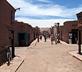 Street view of San Pedro de Atacama
 -
 San Pedro de Atacama Church
 -
 Licancabur volcano viewed from San Pedro de Atacama
 -
 Llamas in the sunset near San Pedro de Atacama
 -
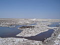 Part of the Chaxas lagoon in the Salar de Atacama.
 -
 Rainbow Valley.
.jpg)


See also
- Atacama Desert
- Puna de Atacama
- Eduardo Abaroa
- List of towns in Chile
- Monturaqui crater
References
- ^ a b c d "National Statistics Institute" (in Spanish). Retrieved 3 November 2010.
- ^ Acuña, Patricia (January 28, 2015). ""Horario de verano" se mantendrá durante todo el año en Chile". biobiochile.cl.
- ^ a b "San Pedro de Atacama". Letsgochile.com.
- ^ Cymerman, A; Rock, PB. "Medical Problems in High Mountain Environments. A Handbook for Medical Officers". USARIEM-TN94-2. US Army Research Inst. of Environmental Medicine Thermal and Mountain Medicine Division Technical Report. Archived from the original on April 23, 2009. Retrieved 2009-03-05.
{{cite journal}}: Cite journal requires|journal=(help)CS1 maint: unfit URL (link) - ^ "Extreme temperatures around the world". mherrera.org. Retrieved 8 February 2024.
- ^ "Climate: San Pedro de Atacama - Climate graph, Temperature graph, Climate table". Climate-Data.org. Retrieved 2013-12-07.
- ^ "Atlas Agroclimático de Chile–Estado Actual y Tendencias del Clima (Tomo I: Regiones de Arica Y Parinacota, Tarapacá y Antofagasta" (in Spanish). Universidad de Chile. 2017. pp. 136–146. Retrieved 9 December 2018.
- doi:10.3917/mouv.076.0013 – via Cairn.info.
External links
- Pictures and Wallpapers of Atacama Region
- Tourism: Tours in San Pedro de Atacama
- San Pedro de Atacama's Travel Assistance
- San Pedro de Atacama's Facebook Page
- San Pedro de Atacama's commune
- R. P. Gustavo Le Paige Archeological Museum
- San Pedro de Atacama Tourism
- Tradiciones de Atacama
- San Pedro de Atacama weather forecasts, compared (Google translations available).

| International | |
|---|---|
| National | |