San (river)
| San | |
|---|---|
 San River in Solina | |
 San River in Vistula watershed | |
| Location | |
| Country | Poland (457 km), Ukraine (1 km) |
| Physical characteristics | |
| Source | Uzhok Pass |
| • location | Piniashkovy Mount, Bukovec Mountains, Ukraine |
| • coordinates | 49°00′19″N 22°52′43″E / 49.00528°N 22.87861°E |
| • elevation | 900 m (3,000 ft) |
| Mouth | Vistula |
• location | Dąbrówka Pniowska, Sandomierz Basin, Poland |
• coordinates | 50°44′15″N 21°50′43″E / 50.73750°N 21.84528°E |
| Length | 458 km (285 mi), S → N |
| Basin size | 16,877 km2 (6,516 sq mi) |
| Discharge | |
| • average | 129 m3/s (4,600 cu ft/s) |
| Basin features | |
| Progression | Vistula→ Baltic Sea |


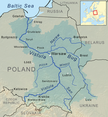
The San (Polish: San; Ukrainian: Сян Sian; German: Saan) is a river in southeastern Poland and western Ukraine. It is a tributary of the river Vistula. With a length of 458 kilometres (285 mi), the San is the 6th-longest Polish river. It has a basin area of 16,877 km2, of which 14,426 km2 is in Poland.[1]
Etymology
*San in proto-Indo-European languages means 'speed' or 'rapid stream'. In Celtic languages, san means 'river'.[2][3][4][5][6]
Course
The San arises in the
.The San flows into the Vistula near Sandomierz.
Tributaries
This section needs expansion. You can help by adding to it. (June 2008) |
|
Left tributaries |
Right tributaries |
History of the region
Historical records first mention the river in 1097 as Sanъ, reku Sanъ, k Sanovi; then as nad Sanomъ (1152) and Sanu (1287). On the old maps of the Ruthenian Voivodeship, Poland 1339–1772 it was referred to as "San" (1339), San (1372), "Szan" (1406), "Sanok" (1438), "Saan" (1439), "Sayn" (1445), "San" (1467), "Szan" (1517), and "Schan" (1526).[8]
Humans had first settled the southeastern region of present-day Poland (the
The San
During the years 966–1018, 1340–1772 (the
The San River, which has seen many battles in its history, was a battle site at the beginning of World War II in 1939. At the outset of the German invasion of Poland, Polish forces attempted to defend a line along the San from September 6, until German forces broke out of their bridgeheads on September 12.
Cities
- Dubiecko, Dynów, Jarosław, Lesko, Leżajsk, Nisko, Przemyśl, Radymno, Rudnik nad Sanem, Sandomierz, Sanok, Sieniawa, Stalowa Wola, Ulanów, Zagórz
See also
- Łęg Rokietnicki
- Rivers of Poland
- Walddeutsche
References
- Statistics Poland, p. 85-86
- Polska Akademia Nauk). 1981. p. 49.
- ISBN 83-04-02472-1S. 64.
- ^ "An adouci en san, eau, rivière; stach, sinueux, qui tourne. Allusion au cours sinueux de la Charente". op. cit. Antiq. de France. [in:] Revue des ëtudes historiques. Société des études historiques. 1835. p.242.; Senne, nom propre de rivière. - Scène, ». L liou on l'on joue. — Seine, sf, sorte de «lot. 17. Cen», sm, impôt. — San, np Sen», sm, jugement [...]". [in:] Dictionnaire de pédagogie et d'instruction primaire. Ferdinand Edouard Buisson. 1883. p. 980.
- ^ "Le terme sawn « cleft, gully » est rapproché du breton san, saon s.f. « aqueduct, san-dour »." Études celtiques. Société d'Éditions "Les Belles Lettres", 1985 p. 337.
- ^ "La racine san est à la base des patronymes: Sangnier, Sagne, Sagnolle, Lassassaigne et Delassassaigne dont un ancentre a habitè près d'un marais." [in:] Paul Bailly. Toponymie en Seine-et-Marne: noms de lieux. Editions Amatteis, 1989. p. 77.
- ^ "PLFOTO - internetowe forum fotograficzne". Retrieved 2 February 2016.
- ISBN 83-88385-14-3. V. 2. San
- ^
"It is possible to separate the group of La Tène culture (Celtic settlement) in the Upper Tisza Basin. For the time being there are about 160 sites noted. They can be divided into several distinct categories which include the following: settlements, production areas, sepulchral sites, i.e., burial grounds and single graves as well as various hoards (deposits of coins and tools). Moreover, there are three oppida: Anarti tribe and the group from southeast Poland as the Anartophracti, which is a part of the former." [in:] Marek Olędzki. La Tène culturein the Upper Tisza Basin =La Culture de la Tene dans le Bassin de la Haute Tisza. Ethnographisch-archaeologische Zeitschrift. ISSN 0012-7477
Literature
- Geographical Dictionary of the Kingdom of Poland and other Slavic Lands Słownik geograficzny Królestwa Polskiego i innych krajów słowiańskich. tom. X, pages 260 - 263. Warszawa. 1876. (digital edition)

