
Sandakphu
This article needs additional citations for verification. (January 2016) |
| Sandakphu | |
|---|---|
List of Indian states and territories by highest point | |
| Coordinates | 27°6′21″N 88°0′6″E / 27.10583°N 88.00167°E[1] |
| Geography | |
 Sandakphu Location of Sandakphu peak | |
| Location | Darjeeling district, West Bengal, India; Ilam District, Koshi Province, Nepal |
| Parent range | Singalila Ridge |
| Topo map | Google topographic map[2] |
| Climbing | |
| Easiest route | Hiking or by car |

Sandakphu or Sandakpur (3636 m; 11,930 ft) is a mountain peak in the Singalila Ridge on the border between India and Nepal. It is the highest point of the ridge and of the state of West Bengal, India. The peak is located at the edge of the Singalila National Park and has a small village on the summit with a few hotels. Four of the five highest peaks in the world, Everest, Kangchenjunga, Lhotse and Makalu can be seen from its summit. It also affords a pristine view of the entire Kangchenjunga Range. Sandakphu is also known as the land of poisonous flowers.
Etymology
The name derives from the Tibeto-Burman Lepcha language and translates as "the height of the poisonous plant" - in reference to the former abundance at the locality (around a century ago) of the poisonous plants Aconitum ferox and certain Rhododendron species. So great was the danger of fatal poisoning to sheep and cattle being driven through the area that they had to be muzzled to prevent them grazing/browsing upon these toxic species (Aconitum ferox has a good claim to being the most poisonous plant species in the world).[3][4]

Trekking
India


5miles
River
Wildlife Sanctuary
National
Park
CT: census town, R: rural/ urban centre, N: neighbourhood, H: hill centre, NP: national park/ wildlife sanctuary, TE: tea estate, TA: tourist attraction
Abbreviations used in names – TG for Tea Garden (town/village), TE for Tea Estate
Owing to space constraints in the small map, the actual locations in a larger map may vary slightly
The trek along the Singalila Ridge to Sandakphu and
Ascent
The Sandakphu Trekking routes inside the Singalila National Park have four legs or stages.
- Manebhanjan to Meghma (2600 m): This is a 4-hour trek through the lower forest. The route goes via Chitre.
- Meghma to Gairibans (2621 m): There are two alternative trekking routes. They respectively go via Tonglu (3070 m) and Tumling (2900 m). From Tumling, a shorter trail cuts through Nepal and Jaubari (2750 m). Jaubari is ward no 07 of jamuna VDC ilam.
- Gairibans to Sandakphu (3636 m):
- Sandakphu to Phalut (3600 m): It is a one-day trek via Sabarkum (3536 m) covering 21 km.
Descent
- Retracing the way back to Manebhanjan.
- A steep descent to the village of Sirikhola on the banks of the River Sirikhola, via Gurdum (2300 m), and from there to Rimbick.
Panorama of Peaks seen from Sandakphu and Phalut[6]
Baruntse (7220m), Chamlang (7319m), Chomo Lonzo (7818m), Lhotse (8516m), Makalu (8462m), Mount Everest (8848m), Nuptse (7861m), Kanchenjunga (8586m), Talung (7349m), Rathong (6679m), Kabru N (7353m), Koktang (6147m), Simvo (6812m), Frey (5853m), Kabru S (7318m), Kabru Dome (6600m), Kabru Forked (6100m), Pandim (6691m), Tenchenkhang (6010m), Jupono (5650m)
Villages At Glance: Gorkhey, Bhareng, Gairibas, Meghma, Maneybhanjyang, Rammam, Srikhola, Sepi, Molley, Gurdum [6]
Nepal
The western part of Sandakphu peak is located in
The trekking starts from
Gallery
-
 Singalila Range and Kanchenjungha seen from Sandakpur
 -
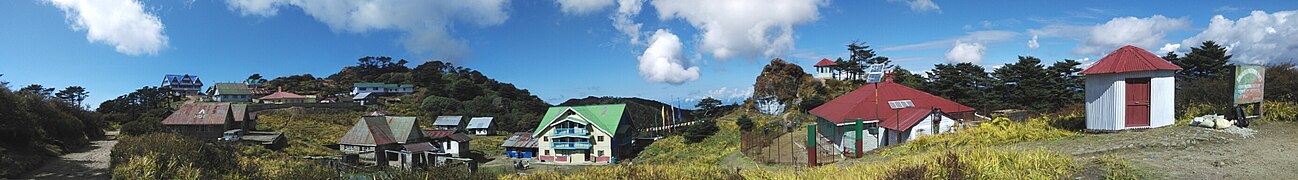 A panoramic view of Sandakpur.
 -
 Domestic yak (Bos grunniens)
 -
 View of Sandakphu from above
 -
 Sandakphu: shrub-clad rocky ridge with toxic, pink-flowered Rhododendron species - for which it was (in part) named


References
- ^ Sandakphu Top - Wikimapia
- ^ Google topographic map
- ^ Rai, Lalitkumar and Sharma, Eklabyar Medicinal Plants of the Sikkim Himalaya: Status, Uses and Potential, pub. Govind Ballabh Pant Inst. Bishen Singh & Mahendra Pal Singh 1994 pps 25-7.
- ^ "Aconitum Ferox Monkshood Strongest Poisonous Plant". Archived from the original on 4 June 2016. Retrieved 13 May 2016.
- ^ , Sandakphu, Trek to Sandakphu, 1 August 2015 Archived 21 August 2015 at the Wayback Machine
- ^ a b "SANDAKPHU PHALUT TREK".
External links
- Mt Everest and Lhotse as seen from Sandakphu
- In the Land of Sleeping Buddha - A Guide to Sandakphu Trek
- Land of the Land Rovers - Community fleet of 57 Series I in daily use from Maneybhanjang to the Sandakphu summit
- 20 Stunning Photos of Sandakphu
- Sandakphu Trek
- All About Sandakphu Trek: Where the Sky Meets the Earth