
Sands End
| Sands End | |
|---|---|
 Sands End Location within Greater London | |
| Population | 12,760 (2011 Census.Ward)[1] |
| OS grid reference | TQ265765 |
| London borough | |
| Ceremonial county | Greater London |
| Region | |
| Country | England |
| Sovereign state | United Kingdom |
| Post town | LONDON |
| Postcode district | SW6 |
| Dialling code | 020 |
| Police | Metropolitan |
| Fire | London |
| Ambulance | London |
| UK Parliament | |
| London Assembly | |
Sands End is an area of the ancient parish of
History
This section needs additional citations for verification. (July 2017) |
.jpg)

For centuries, this swampy place was a rural backwater, cut off from other villages and the main thoroughfares into the
Ten years later,

Origins
The historian of Fulham, Charles Féret (1852-1921), devotes several chapters of his 3 volume work to the origins of Sands End. As distinct from ownership, settlement of the area did not begin till the
Industrialisation

In spite of its rural charms, the area was affected by flooding, dampness and the effluent descending from Counter's Creek, sometimes referred to as a sewer, so by the early 19th-century, the estate was in decline. Dr Barton MD, author of 'the Lost Rivers of London', quotes a colleague from the West London Medical Journal, who had observed that rheumatism was unusually common on both sides of Counter's Creek from Shepherd's Bush to Chelsea.[5]
In 1824, twenty acres of the estate were bought by the
The growth of the Temperance movement produced yet another brewery in Fulham, only without any alcohol content. On an eight-acre site in Sands End, just east of Wandsworth Bridge, the Polish-born entrepreneur, Henry Lowenfeld built the Kops Brewery that started production in 1890. It lasted to the dawn of World War I when it was turned into a margarine factory and later turned to food logistics.[7]
In 1901,
-
 Joseph Addison by Michael Dahl lowres
 -
 Gasholderat the former Imperial Gasworks
 -
 William De Morgan (c. 1890), Sands Ends Pottery: a tile inspired by Middle Eastern patterns.
 -
 The Queen Elizabeth public house, Pearscroft Road
 -
 The Castle Club, Daisy Lane, Fulham
 -
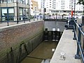 Chelsea Harbour Lock
 -
 The former Kops Brewery, Townmead Road, Sands End


21st-century
A property boom begun in the 1970s coupled with the advent of oil-fuelled processing of North Sea oil led to a process of Gentrification with offices and studio businesses and flats on the market for prices more customary in the centre of the capital.[9] On the northern bank of the
Also in this part of Fulham is South Park. Wandsworth Bridge Road runs through Sands End and has restaurants, tile and pine furniture shops, the Church of England parish church of Saint Matthew.[citation needed]
Transport

Because of the notoriously poor transport links for the area (including Chelsea Harbour), including the absence of tube stations due to the many medieval plague pits which deterred their building in Victorian times, the nearby

River bus services are provided at peak hours by
References
- ^ "Hammersmith and Fulham Ward population 2011". Neigfhbourhood Statistics. Office for National Statistics. Retrieved 15 October 2016.
- ^ Historic England. "Sandford Manor House, Kings Road SW6 (1286723)". National Heritage List for England. Retrieved 3 April 2015.
- ISBN 0-948667-43-5.
- ^ Féret, Charles (1900). Fulham Old and New, vol.I-III. Vol. III. Leadenhall Press. pp. 267–87. Retrieved 29 July 2017.
- ISBN 0-948667-15-X.
- ^ "William De Morgan and the Arts & Crafts Movement". Antique Marks. Retrieved 2 October 2016.
- ISBN 0-948667-43-5.
- ISBN 9781840335262.
- ISBN 9781840335262.
- ^ "Boats from Chelsea Harbour Pier" (PDF). Transport for London. Spring 2009. Retrieved 29 July 2017.
External links
- Fulham Power Station, Sands End (1937), BritainfromAbove.org.uk; retrieved 29 July 2017
- Fulham Power Station, rbkclocalstudies.wordpress.com; retrieved 29 July 2017
- A history project by Langford Primary School; retrieved 29 July 2017
- Sands End; retrieved 28 October 2016
In October 2008 an interactive local history website, Sands End Revisited, was published with photos and memories from residents closed in 2015, but e-mail contact available.[1]


Places adjacent to Sands End | ||||||||||||||||
|---|---|---|---|---|---|---|---|---|---|---|---|---|---|---|---|---|
| ||||||||||||||||
- ^ "Welcome to the SandsEndRevisited.net". Archived from the original on 23 January 2009.