
Sandy Hook
Sandy Hook | |
|---|---|
JFK International Airport in New York City | |
 Sandy Hook | |
| Coordinates: 40°27′11″N 73°59′42″W / 40.4530°N 73.9950°W | |
| Location | Middletown Township, Monmouth County, New Jersey, United States |
| Offshore water bodies | Atlantic Ocean (to the east) Shrewsbury River (to the west) |
| Age | Last Glacial Maximum ("LGM"; ≈25,000 years old) |
| Formed by | Wisconsin glaciation period |
| Operator | National Park Service |
| Area | |
| • Total | 2,044 acres (827 ha) |
| Dimensions | |
| • Length | 6 miles (9.7 km) |
| • Width | 0.1 to 1.0 mile (0.16 to 1.61 km) |
| • Depth | 250 to 300 feet (76 to 91 m)[1] |
| Elevation | 2 m (7 ft) |
| Designation | Barrier spit |

Sandy Hook is a barrier spit in Middletown Township, Monmouth County, New Jersey, United States.[3] The barrier spit, approximately 6 miles (9.7 km) in length and varying from 0.1 to 1.0 mile (0.16 to 1.61 km) wide, is located at the north end of the Jersey Shore. It encloses the southern entrance of Lower New York Bay south of New York City, protecting it from the open waters of the Atlantic Ocean to the east.
The Dutch called the area "Sant Hoek", with the
Most of Sandy Hook is owned and managed by the National Park Service as the Sandy Hook Unit of Gateway National Recreation Area.
Description

Sandy Hook is part of Middletown Township, although not contiguous with the rest of the Township. Because the peninsula is also federal enclave, Middletown and the federal government have a Concurrent jurisdiction. The community of Highlands overlooks the southern part of the hook.
Sandy Hook is owned by the federal government. Most of it is managed by the
Military history
The defunct
North of Fort Hancock on the western part of the "hook" is an active station of the
Tourism and recreation
The beaches along the Atlantic shore of Sandy Hook—North Beach,
Within Sandy Hook some laws and regulations are different. Sandy Hook falls under Title 36 of the Code of Federal Regulations, as well as New Jersey State Code in instances where federal laws do not pertain. In Sandy Hook a misdemeanor could be a federal crime while outside the park it would be a minor infraction.[citation needed]
Accommodations near Sandy Hook include
Local activities include the Sandy Hook All Woman Lifeguard Tournament in July, boat rentals for fishing, parties and tours, and paved path for biking, rollerblading, and walking. The
The northern tip of Sandy Hook is the traditional finish of the 16.1 mile Ederle-Burke Swim, which runs from the Battery at the tip of Manhattan Island through the Narrows and into Lower New York Bay. The first successful swim occurred in 1913, when New York lifeguard Alfred Brown came ashore in 13 hours, 38 minutes. As a prelude to her English Channel triumph, Gertrude Ederle swam the same course in 1925, finishing in 7 hours, 11 minutes.[citation needed]
Transportation
The road that connects to Sandy Hook is
A bicycle path parallels the motor road. The
Climate
According to the Köppen climate classification system, Sandy Hook has a humid subtropical climate (Cfa). Cfa climates are characterized by all months having an average temperature > 32.0 °F (0.0 °C), at least four months with an average temperature ≥ 50.0 °F (10.0 °C), at least one month with an average temperature ≥ 71.6 °F (22.0 °C) and no significant precipitation difference between seasons. Although most summer days feature slight-to-moderate humidity and a cooling afternoon sea breeze in Sandy Hook, episodes of heat and high humidity can occur with heat index values > 105 °F (41 °C). Since 1981, the highest air temperature was 99.7 °F (37.6 °C) on August 9, 2001, and the highest daily average mean dew point was 78.0 °F (25.6 °C) on July 19, 2019. The average wettest month is July which correlates with the peak in thunderstorm activity.
Since 1981, the wettest calendar day was 5.61 inches (142 mm) on August 27, 2011. During the winter months, the average annual extreme minimum air temperature is 6.3 °F (−14.3 °C).[13] Since 1981, the coldest air temperature was −3.0 °F (−19.4 °C) on January 21, 1985. Episodes of extreme cold and wind can occur with wind chill values < −3 °F (−19 °C). The average seasonal (Nov-Apr) snowfall total is between 18 inches (46 cm) and 24 inches (61 cm), and the average snowiest month is February which corresponds with the annual peak in nor'easter activity.
| Climate data for Sandy Hook, 1981-2010 normals, extremes 1981-2019 | |||||||||||||
|---|---|---|---|---|---|---|---|---|---|---|---|---|---|
| Month | Jan | Feb | Mar | Apr | May | Jun | Jul | Aug | Sep | Oct | Nov | Dec | Year |
| Record high °F (°C) | 70.2 (21.2) |
77.6 (25.3) |
82.1 (27.8) |
90.1 (32.3) |
94.3 (34.6) |
95.3 (35.2) |
99.4 (37.4) |
99.7 (37.6) |
96.2 (35.7) |
92.1 (33.4) |
77.5 (25.3) |
74.6 (23.7) |
99.7 (37.6) |
| Mean daily maximum °F (°C) | 39.1 (3.9) |
41.9 (5.5) |
48.7 (9.3) |
58.3 (14.6) |
68.0 (20.0) |
77.7 (25.4) |
82.8 (28.2) |
81.7 (27.6) |
75.4 (24.1) |
64.4 (18.0) |
54.5 (12.5) |
44.5 (6.9) |
61.5 (16.4) |
| Daily mean °F (°C) | 32.7 (0.4) |
34.9 (1.6) |
41.2 (5.1) |
50.6 (10.3) |
60.4 (15.8) |
70.1 (21.2) |
75.5 (24.2) |
74.7 (23.7) |
68.3 (20.2) |
57.1 (13.9) |
47.8 (8.8) |
38.4 (3.6) |
54.4 (12.4) |
| Mean daily minimum °F (°C) | 26.3 (−3.2) |
28.0 (−2.2) |
33.7 (0.9) |
43.0 (6.1) |
52.8 (11.6) |
62.5 (16.9) |
68.3 (20.2) |
67.7 (19.8) |
61.1 (16.2) |
49.7 (9.8) |
41.2 (5.1) |
32.2 (0.1) |
47.3 (8.5) |
| Record low °F (°C) | −3.0 (−19.4) |
2.3 (−16.5) |
10.0 (−12.2) |
19.1 (−7.2) |
40.2 (4.6) |
48.2 (9.0) |
54.0 (12.2) |
49.4 (9.7) |
42.9 (6.1) |
33.4 (0.8) |
17.1 (−8.3) |
1.6 (−16.9) |
−3.0 (−19.4) |
| Average precipitation inches (mm) | 3.27 (83) |
2.55 (65) |
3.63 (92) |
4.01 (102) |
3.67 (93) |
3.96 (101) |
4.57 (116) |
3.92 (100) |
3.54 (90) |
3.69 (94) |
3.32 (84) |
3.77 (96) |
43.90 (1,115) |
| Average relative humidity (%)
|
66.3 | 62.5 | 61.6 | 62.8 | 66.8 | 70.1 | 70.4 | 70.8 | 71.9 | 68.7 | 67.3 | 65.9 | 67.1 |
| Average dew point °F (°C) | 22.7 (−5.2) |
23.4 (−4.8) |
29.0 (−1.7) |
38.4 (3.6) |
49.3 (9.6) |
59.9 (15.5) |
65.2 (18.4) |
64.6 (18.1) |
58.9 (14.9) |
46.9 (8.3) |
37.5 (3.1) |
28.0 (−2.2) |
43.7 (6.5) |
| Source: PRISM[14] | |||||||||||||
| Climate data for Sandy Hook Buoy, NJ (Ocean Water Temperature) | |||||||||||||
|---|---|---|---|---|---|---|---|---|---|---|---|---|---|
| Month | Jan | Feb | Mar | Apr | May | Jun | Jul | Aug | Sep | Oct | Nov | Dec | Year |
| Daily mean °F (°C) | 37 (3) |
36 (2) |
40 (4) |
46 (8) |
55 (13) |
62 (17) |
69 (21) |
72 (22) |
68 (20) |
59 (15) |
51 (11) |
43 (6) |
53 (12) |
| Source: NOAA[15] | |||||||||||||
Ecology
According to the
Gallery
-

-
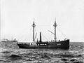 Lightship#51 at Sandy Hook as it appeared in the 1890s.
 -
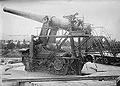 Aiming a 14-inch gun at the Sandy Hook Proving Ground
 -
 20-inch Rodman gun with shells
 -
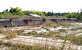 Abandoned gun platforms of the Sandy Hook Proving Ground
 -
 Part of a mortar battery installation near Sandy Hook Light
 -
 Among the many beaches on Sandy Hook,clothing optional.


.jpg)
See also
- Atlantic Highlands, New Jersey
- Fort Hancock, New Jersey
- Gateway National Recreation Area
- Sandy Hook Light
- Sandy Hook Pilots
- Sandy Hook Proving Ground
- The Leander affair
References
- ^ "Coreholes Reveal Glacial and Postglacial History at Sandy Hook" (PDF). Unearthing New Jersey. 11 (1). Trenton, NJ: New Jersey Department of Environmental Protection: 3. 2015. Retrieved September 4, 2016.
- ^ "Sandy Hook". Geographic Names Information System. United States Geological Survey, United States Department of the Interior.
- ^ Greenfield, Beth (August 5, 2005). "Sandy Hook, So Close to Manhattan, So Far Away in Spirit". The New York Times. Retrieved September 4, 2016.
- ^ "The Atlantic World: Dutch Place Names / De Atlantische Wereld: Plaatsnamen". Dutch Place Names. Library of Congress. Retrieved September 4, 2016.
- ^ Rueb, Emily (November 17, 2016). "The Channel Masters of New York Harbor". New York Times. Retrieved January 29, 2020.
- ^ a b c d e Rounds, Kate, ed. (2010). "The Shore Next Door". Palisade - Hoboken & Beyond. 4 (3). Hudson Reporter Assoc., LP: 38–39. Retrieved September 4, 2016.
- ^ "Sea Streak". Sea Streak. Retrieved December 17, 2012.
- ^ Trebay, Guy (September 2, 2001). "All Undressed and So Many Places to Go". New York Times. Retrieved August 21, 2007.
- ^ Flam, Faye. "Clothing optional may not be way of historical human", The Philadelphia Inquirer, July 17, 2006. Accessed June 17, 2007. "Sandy Hook boasts the biggest nude beach along the Atlantic. The clothing-optional part is called Gunnison Beach ...."
- ^ "Station Sandy Hook, New Jersey" (PDF). U.S. Coast Guard History Program. United States Coast. Retrieved December 17, 2012.
- ^ "Sea Streak". Sea Streak. Retrieved December 17, 2012.
- ^ "American Princess Cruises". Newyorkbeachferry.com. Retrieved December 17, 2012.
- ^ a b "USDA Interactive Plant Hardiness Map". United States Department of Agriculture. Archived from the original on July 4, 2019. Retrieved July 1, 2020.
- ^ "PRISM Climate Group, Oregon State University". Retrieved July 1, 2020.
- ^ "Water Temperature Table of All Coastal Regions". Retrieved August 1, 2019.
- ^ "U.S. Potential Natural Vegetation, Original Kuchler Types, v2.0 (Spatially Adjusted to Correct Geometric Distortions)". Retrieved July 5, 2020.
- ^ "Phenology Visualization Tool". Retrieved July 5, 2020.
External links
- Sandy Hook Visitor Information
- National Park Service Gateway National Recreation Area
- Nike Missile Site NY-56 Archived May 14, 2011, at the Wayback Machine
| Neighborhoods |  | |
|---|---|---|
| Schools | ||
| Parks and recreation | ||
| NRHP sites | ||
| Public transportation | ||
| Roads and highways | ||
| Other points of interest | ||
This list is incomplete. | ||

| International | |
|---|---|
| National | |
| Other | |