
Sandy Springs, Georgia
This article needs additional citations for verification. (March 2024) |
Sandy Springs, Georgia | ||
|---|---|---|
 The contemporary skyline of Sandy Springs is dominated by the Concourse office towers, as seen in 2013. | ||
|
FIPS code 13-68516 | | |
| GNIS feature ID | 0332975[1] | |
| Website | sandyspringsga.gov | |
Sandy Springs is a city in northern
History
Human settlement in the area can be traced back to approximately 400 CE, when Native Americans forged three trails to better access the area's freshwater springs.[7] In the 16th century, the Creek Muskogee tribe settled the area, where they remained until the early 1800s, when they were forced out of the area due to the discovery of gold.[7]
In 1821, the federal government held a number of land lotteries in the area, resulting in the purchase of land in present-day Sandy Springs and its subsequent settlement.[7] The Austin-Johnson House, the oldest existing unaltered house, was built in 1842 on what is now Johnson Ferry Road.[7] In 1851, Wilson Spruill donated 5 acres (2.0 ha) of land for the founding of Sandy Springs United Methodist Church, near the natural spring for which the city is named.[8] In 1905, the Hammond School was built at Johnson Ferry Road and Mt. Vernon Highway, across the street from the church.[citation needed]
20th century
In 1950, the state legislature blocked Atlanta from annexing the community, which remained rural until the Interstate Highway System was authorized by the Federal-Aid Highway Act of 1956. In 1959, after a fire at Hammond Elementary School,
In 1965, Hartsfield once again proposed the annexation of the Sandy Springs area. Spokesmen for Sandy Springs promised residents to "build up a city separate from Atlanta and your Negroes and forbid any Negroes to buy, or own, or live within our limits" should they reject annexation.[9] In 1966, annexation by Atlanta was defeated in a referendum, with two-thirds voting against.[citation needed]
Efforts to incorporate Sandy Springs began in 1966 in response to attempts by the city of Atlanta to annex this unincorporated area of north Fulton County.[citation needed]
In the early 1970s, the city of Atlanta attempted to use a state law to force annexation of Sandy Springs, which failed after the Supreme Court of Georgia ruled that the law was unconstitutional. In response, a group of residents formed the Committee for Sandy Springs 1975 to lobby for the incorporation of Sandy Springs.[7]
During this time, proponents for an incorporated Sandy Springs argued that their taxes were disproportionately going to other, largely non-white, communities in Fulton County.
In 1991, the Georgia state government determined that Sandy Springs, along with other wealthier, and predominantly white, communities in Fulton County was being taxed below statewide minimums, resulting in an increase in taxes for the area.[10] Some Sandy Springs residents, including Mitch Skandalakis, launched a number of campaigns against the taxes, and launched an unsuccessful lawsuit against the state.[10]
On January 16, 1997, Eric Rudolph bombed an abortion clinic in Sandy Springs.[11][12]
21st century
When the Republican Party gained a majority in both houses of the Georgia General Assembly in 2005, the procedural rules previously used to prevent a vote by the full chamber were changed so that the bill was handled as a state bill and not as a local bill.[citation needed] The assembly also repealed the requirement that new cities must be at least 3 miles (4.8 km) from existing cities that had stymied previous attempts to incorporate due to Sandy Springs directly bordering both Roswell and Atlanta.[citation needed] The bill allowing for a referendum on incorporation was introduced and passed as HB 37.[13] The referendum initiative was approved by the Assembly and signed by Governor Sonny Perdue.
Many residents expressed displeasure with county services, claiming, based upon financial information provided by the county, that the county was redistributing revenues to fund services in less financially stable areas of the county, ignoring local opposition to rezoning, and allowing excessive development. Many residents of unincorporated and less-developed south Fulton County strongly opposed incorporation, fearing the loss of tax revenues which fund county services. County residents outside Sandy Springs were not allowed to vote on the matter. Efforts such as requesting the Justice Department to reject the plan were unsuccessful.[citation needed]
The referendum was held on June 21, 2005, and residents voted 94% in favor of incorporation.
Formal incorporation occurred on December 1, making Sandy Springs the third-largest city ever to incorporate in the U.S.[2] The city's police force and fire department began service in 2006. Upon incorporation, Sandy Springs initiated a nontraditional approach by operating as a public-private partnership (PPP), with all but six full-time employees being contracted.[14]
In 2010, the city undertook a procurement process to rebid all general city services, which was won by
In 2010, the city became the first jurisdiction in Georgia to successfully "bail out" from the preclearance requirements of Section 5 of the Voting Rights Act.[15]
In 2019, the Sandy Springs City Council moved to scale back the PPP model, directly hiring 183 contract employees, leaving only 15 outsourced full-time workers by the end of 2019.[16] The city will still outsource a number of services, including the city attorney's office, as well as security, street sweeping and ambulance services.[16] The move is expected to save $2.7 million in the next year and more than $14 million over 5 years.[14][16]
Geography
The boundaries of Sandy Springs are Atlanta to the south, Cobb County (at the Chattahoochee River) to the west and north, Roswell (also at the river) to the north, and Dunwoody and Brookhaven, at the DeKalb County line, to the east. A small panhandle in the northeast extends between the Chattahoochee River to the north and Dunwoody to the south, ending in a very small border with Peachtree Corners in the extreme western edge of Gwinnett County.
Climate
Sandy Springs has a
| Climate data for Sandy Springs | |||||||||||||
|---|---|---|---|---|---|---|---|---|---|---|---|---|---|
| Month | Jan | Feb | Mar | Apr | May | Jun | Jul | Aug | Sep | Oct | Nov | Dec | Year |
| Record high °F (°C) | 75 (24) |
80 (27) |
88 (31) |
91 (33) |
95 (35) |
101 (38) |
102 (39) |
101 (38) |
98 (37) |
88 (31) |
84 (29) |
76 (24) |
102 (39) |
| Mean daily maximum °F (°C) | 50 (10) |
55 (13) |
63 (17) |
71 (22) |
78 (26) |
84 (29) |
88 (31) |
86 (30) |
81 (27) |
72 (22) |
62 (17) |
53 (12) |
70 (21) |
| Mean daily minimum °F (°C) | 29 (−2) |
32 (0) |
38 (3) |
45 (7) |
54 (12) |
62 (17) |
67 (19) |
66 (19) |
60 (16) |
47 (8) |
39 (4) |
32 (0) |
48 (9) |
| Record low °F (°C) | −10 (−23) |
1 (−17) |
6 (−14) |
24 (−4) |
31 (−1) |
40 (4) |
48 (9) |
50 (10) |
28 (−2) |
25 (−4) |
10 (−12) |
−1 (−18) |
−10 (−23) |
| Average precipitation inches (mm) | 5.34 (136) |
4.78 (121) |
5.52 (140) |
4.04 (103) |
4.63 (118) |
3.66 (93) |
4.17 (106) |
4.32 (110) |
3.87 (98) |
3.58 (91) |
3.73 (95) |
4.18 (106) |
51.82 (1,316) |
| Source: [18] | |||||||||||||
Neighborhoods


Downtown—City Springs
City Springs, the downtown district of Sandy Springs, is usually defined as the area to the south and east of Sandy Springs Circle, to the north of
Riverside
Riverside is the western district of the city, located south of Dalyrmple Road and west of Roswell Road, bordering the Chattahoochee River to the west, forming the western border with Cobb County. It is a high-income, residential area marked by winding, hilly roads and old growth forest. The main roads are Heards Ferry Road and Riverside Drive, and it is located off the Riverside Drive exit of I-285. Two of the public schools within Sandy Springs are located here, Heards Ferry Elementary and
The Panhandle
The Dunwoody Panhandle, or just "The Panhandle" is a residential area bounded by the
Perimeter Center
North Springs
North Springs is located in the northern portion of the city, and is generally defined as the area west of the Dunwoody/DeKalb County border, east of Brandon Mill Road, north of Abernathy Road, and south of Dalrymple Road and Spalding Drive. The
South Springs—Sandy Springs ITP
South Springs or Sandy Springs ITP, an acronym for "inside the perimeter", refers to a portion of the city which extends south of Interstate 285, colloquially referred to as "the perimeter".
Powers Ferry Landing
The business district just east of the river crossing is called Powers Ferry Landing, located where Northside Drive crosses the road, just east of the former landing. This provides freeway access at Northside Drive (west ramps) and New Northside Drive (east ramps, road and ramps built in a 1990s reconstruction). Signage on the freeway indicates Powers Ferry Road, Northside Drive, and New Northside Drive.[32]
North End
The North End is a large district in the northernmost portion of the city, and is generally defined as the area to the west of GA400, to the south and east of the Chattahoochee River, and to the north of Dalrymple Road. It is accessible via GA400 at Northridge Road, and contains the Northridge business area and the North River Village community. The Huntcliff community is located west of the district, on a panhandle to the northwest.[citation needed]
Demographics
| Census | Pop. | Note | %± |
|---|---|---|---|
| 1980 | 46,877 | — | |
| 1990 | 67,842 | 44.7% | |
| 2000 | 85,781 | 26.4% | |
| 2010 | 93,853 | 9.4% | |
| 2020 | 108,080 | 15.2% | |
| U.S. Decennial Census[33] 1850-1870[34] 1870-1880[35] 1890-1910[36] 1920-1930[37] 1940[38] 1950[39] 1960[40] 1970[41] 1980[42] 1990[43] 2000[44] 2010[45] 2020[46] | |||
Sandy Springs was first listed as a
(Note: the
2020 census
| Race / Ethnicity (NH = Non-Hispanic) | Pop 2000[47] | Pop 2010[45] | Pop 2020[46] | % 2000 | % 2010 | % 2020 |
|---|---|---|---|---|---|---|
White alone (NH)
|
62,657 | 55,066 | 58,130 | 73.04% | 58.67% | 53.78% |
Black or African American alone (NH)
|
10,139 | 18,092 | 19,773 | 11.82% | 19.28% | 18.29% |
Alaska Native alone (NH)
|
99 | 160 | 137 | 0.12% | 0.17% | 0.13% |
| Asian alone (NH) | 2,793 | 4,660 | 10,160 | 3.26% | 4.97% | 9.40% |
| Pacific Islander alone (NH) | 40 | 33 | 56 | 0.05% | 0.04% | 0.05% |
| Some Other Race alone (NH) | 327 | 671 | 806 | 0.38% | 0.71% | 0.75% |
| Mixed Race or Multi-Racial (NH) | 1,212 | 1,803 | 4,278 | 1.41% | 1.92% | 3.96% |
| Hispanic or Latino (any race) | 8,514 | 13,368 | 14,740 | 9.93% | 14.24% | 13.64% |
| Total | 85,781 | 93,853 | 108,080 | 100.00% | 100.00% | 100.00% |
As of the 2020 United States census, there were 108,080 people, 52,820 households, and 25,861 families residing in the city.

2010 census
In the official
2000 census
In the preceding official census of 2000, when there were 85,781 people, 39,288 households, and 19,683 families residing in the CDP, the population density was 2,274.1 inhabitants per square mile (878.0/km2). There were 42,794 housing units at an average density of 1,134.5 per square mile (438.0/km2). The racial makeup of the CDP was 77.55%
There were 48,288 households, out of which 21.1% had children under the age of 18 living with them, 40.1% were married couples living together, 7.0% had a female householder with no husband present, and 49.9% were non-families. 35.9% of all households were made up of individuals, and 6.8% had someone living alone who was 65 years of age or older. The average household size was 2.17 and the average family size was 2.87.
In the CDP, the age distribution of the population shows 17.8% under the age of 18, 10.5% from 18 to 24, 40.3% from 25 to 44, 21.6% from 45 to 64, and 9.8% who were 65 years of age or older. The median age was 33 years. For every 100 females, there were 96.6 males. For every 100 females age 18 and over, there were 95.0 males.
According to a 2008 estimate, the median income for a household in the city was $106,240, and the median income for a family was $129,810. The average income for a household was $116,406 and the average income for a family was $169,815. Males had a median income of $60,053 versus $50,030 for females. About 3.1% of families and 7.9% of the population were below the
Arts and culture
Museum
The Heritage Sandy Springs Museum opened on March 20, 2010. It is dedicated to the history of the Sandy Springs community and is located in the repurposed Williams-Payne house at Heritage Green. Two notable exhibits are "Sandy Springs: Land and People", which tells the changing story of Sandy Springs as the home of Native Americans, rural farmers, and modern suburbanites; and "A Land Nearby", which features a collection of 20 photographs of Georgia's Barrier Island taken by Dr. Curt Hames Jr.
Sandy Springs also has a museum devoted to Anne Frank.
Annual festivals
Sandy Springs offers a host of annual events each year.
The Sandy Springs Festival is the largest community event in Sandy Springs, with approximately 30,000 attendees. Established in 1984, the annual festival celebrated its 30th year in 2015. The festival features a juried artist's market, civic and business expo, performances by regional acts and community bands, a children's area with crafts and activities, a teen territory with
Sandy Springs Artsapalooza is a free fine arts festival held each year in Sandy Springs. Each year 125 to 150 notable artists from across the country have the opportunity to participate. Organizers of the event include the Georgia Foundation for Public Spaces and ArtsSpring, two groups that are dedicated to bringing free arts programs to the community.[54]
Stars and Stripes Celebration is an annual community fireworks display held over the July 4 holiday. The community previously gathered on the Concourse lawn for fireworks and live music, but in 2020 they moved the fireworks from the Concourse to City Springs.[55]
The annual Chattahoochee River Summer Splash, held in July, is a 6-mile (10 km) float along the Chattahoochee River, beginning at Morgan Falls Dam and finishing at Cochran Shoals-Powers Island National Recreation Area. After completing the float, participants can enjoy an afternoon of live music, food and fun during festivities at Powers Island. Guests can bring their own kayaks, canoes, or rafts, or rent them from several local outfitters. Morgan Falls Park is the hub for paddleboard and raft rentals in Sandy Springs.
Parks and recreation


Sandy Springs' sixteen parks and greenspaces offer more than 950 acres (380 ha) of parkland.[56]
- Abernathy Greenway: The city's newest park, 6.6-acre linear park opened in 2014. The playable art structures were created as part of an international competition developed by the Sandy Springs Conservancy and Art Sandy Springs and sponsored by Northside Hospital.
- Heritage Green: a 4-acre (1.6 ha) park at the center of Sandy Springs' new downtown development. It is the site of the original underground springs for which the city is named and is anchored by the Heritage Sandy Springs Museum. It is operated and managed by Heritage Sandy Springs, a 501(c)(3)nonprofit organization dedicated to building community through preserving and promoting the historic and cultural identity of Sandy Springs. Heritage Sandy Springs presents a full calendar of public programs and events, including the Sandy Springs Festival, museum exhibits, lectures and programs, three concert series, children's educational and enrichment programming, and community gardening programs.
- Hammond Park: multipurpose building, gym, game room, AstroTurf soccer field, lighted tennis courts, basketball courts, picnic pavilions, playground, restrooms
- Morgan Falls Overlook: picnic pavilions, children's playground, boat dock/fishing pier, hiking trail, fire pit, porch swings, scenic views, restrooms
- Morgan Falls Athletic Complex: baseball and softball fields, football fields, picnic pavilions, playgrounds, concessions stand, restrooms
- Sandy Springs Tennis Center: clubhouse, pro shop, restrooms, locker rooms, lighted tennis courts, jogging trail
- Abernathy Park: tennis courts, playground, picnic tables, arts center
- Allen: playground, multipurpose court, walking trail, basketball court
- John Ripley Forbes Big Trees Forest Nature: trails, tree, plant and wildlife sanctuary[57]
- Ridgeview: nature trails, picnic pavilion, playground
- Windsor Meadows: benches and trails located at the intersection of Windsor Parkway and Northland Drive by Nancy Creek
- Island Ford: home to the headquarters for the Chattahoochee National Recreation Area, this unit is located entirely within Sandy Springs. It is also home to the Hewlett Lodge, a former home dating back to 1941 that was acquired when the park service bought the land surrounding the home in 1979.
- East Palisades: this park compromises the Fulton County portion of the Palisades unit.
- Powers Island: this park is a part of the Cochran Shoals unit of the Chattahoochee National Recreation Area.
Government
Officials
- Mayor: Rusty Paul
- District 1: John Paulson
- District 2: Melody Kelley
- District 3: Melissa Mular
- District 4: Jody Reichel
- District 5: Tiberio "Tibby" DeJulio
- District 6: Andy Bauman
- City Manager: Eden Freeman
Services
Sandy Springs was noted for contracting private companies to perform the majority of its services in a public-private partnership model of government at the beginning of its incorporation in 2005.[58] While many governments contract with private-sector companies on a per-project basis, Sandy Springs is believed to be the first American city to outsource its services for the majority of ongoing operations. They chose to do so as an economic response to the Great Recession. The city regularly hosted delegations from other governments that were interested in the model.[59] Services not outsourced include police, fire-rescue, and city management. The city moved away from the private-public partnership model in 2019 when it was realized how much money was lost to private contractors and hired 184 full-time city staff that work at the new City Springs development. It now operates as a hybrid model, outsourcing projects to private companies as needed. The city estimates $14 million will be saved over the next five years from hiring full-time staff.[60]
The Sandy Springs Police Department (SSPD) is the city's police department[61] and took over services from Fulton County on July 1, 2006, with 86 original police officers recruited from various police agencies from all over the State of Georgia. The department currently has an authorized staff of 149 full-time sworn officers and 11 part-time officers. Additionally, the SSPD also employs 23 civilian staff members who handle duties such as records, permits, GCIC, and fleet maintenance. The current Executive Officer is Chief Kenneth DeSimone, who assumed the position in 2013 from Terry Sult, who replaced Gene Wilson in 2008 as the department's first chief. The department answered 124,374 calls for service and made 3,390 arrests in 2020.
Dedicated units of the SSPD include Uniform Patrol, Bike Unit, Community Affairs, Crime Scene Investigations, Criminal Investigation Division, Criminal Intelligence Unit, Crisis Negotiation Team, Honor Guard, K-9 Unit, Quick Response Force, Special Investigation Unit, Swift Water Rescue Team, Traffic Unit, and the Training Unit. Further, the SSPD is a member of the North Metro SWAT Team, consisting of officers from Sandy Springs Police Department, Dunwoody Police Department, Johns Creek Police Department, and the Brookhaven Police Department. The SSPD headquarters is located at 7840 Roswell Road, Suite 301, within the Morgan Falls Office Park.
The city's fire department began operations in December 2006. The department consists of 97 full-time firefighters. Chief Jack McElfish headed the fire department from 2005 to 2014. The fire department is today[when?] led by Chief Keith Sanders. It is staffed by 113 full-time firefighters. The fire department handled 17,000 responses to 8,205 calls for service
The city of Sandy Springs has purchased the old
Education
Primary and secondary schools

Private schools located in Sandy Springs include:
- Brandon Hall School (5th grade through high school)
- Springmont (formerly First Montessori School of Atlanta) (preschool through middle school)
- Atlanta Jewish Academy (K–12)
- Holy Innocents' Episcopal School (preschool through high school)
- Mount Vernon Presbyterian School (preschool through high school)
- St. Jude the Apostle Catholic School (K–8)[65]
- Opened September 4, 1962[66]
- The Alfred and Adele Davis Academy (K–8)
- The Felicia Penzell Weber Jewish Community High School a.k.a. The Weber School (high school)
- The Epstein School (K–8)
- Holy Spirit Preparatory School Lower Campus (the upper campus and preschool are in Atlanta)[67][68]
- Cumberland Academy
The initial campus of Sophia Academy, which opened in 1999, was on a rental property,[69] in what became Sandy Springs.[70][71] Construction on its new campus on what later became Chamblee began circa 2007.[69]
Public libraries
Economy
The largest employers within Sandy Springs are hospitals, headquarters and regional offices from a variety of industries including computer related services, package delivery, telecommunications, media, and financial transaction processing.
Sandy Springs is home to three hospitals:
Top employers
According to the city's 2021 Comprehensive Annual Financial Report,[73] the top employers in the city are:
| # | Employer | # of employees |
|---|---|---|
| 1 | United Parcel Service | 2,081 |
| 2 | OneTrust | 2,043 |
| 3 | IBM | 1,935 |
| 4 | David Green | 1,300 |
| 5 | Manheim Auctions | 1,136 |
| 6 | Intercontinental Exchange | 994 |
| 7 | VMware | 960 |
| 8 | Inspire Brands & subsidiaries | 931 |
| 9 | Cox Communications | 908 |
| 10 | Cox Enterprises | 828 |
Media
Some notable newspapers that cover areas of interest to Sandy Springs include the Sandy Springs Reporter
Infrastructure
Major roads and expressways
Sandy Springs is served by two major limited-access
Recently completed major road projects include the widening of Abernathy Road between Johnson Ferry and Roswell Roads from two lanes to four plus a
The city's
The 2008
Mass transit
The major provider of
-
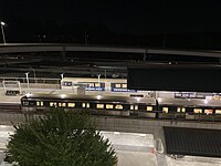 North Springs MARTA Station overlooking GA 400
 -
 MARTA Bus Stop on Roswell Road


Pedestrians and cycling
Currently the city is limited in multi-use trails, but bike lanes can be found in certain parts of the city. The city is currently working on creating more trails and bike lanes. Currently, the Abernathy Greenway is a popular multi-use trail running adjacent to Abernathy Road, connecting to Abernathy Park. The
Diplomatic missions
The city has one consulate general:
References
- ^ a b c U.S. Geological Survey Geographic Names Information System: Sandy Springs, Georgia
- ^ a b Daughters of the American Revolution, Sandy Springs Chapter (2010). "City of Sandy Springs - From the Daughters of the American Revolution, Sandy Springs Chapter". City of Sandy Springs. Archived from the original on July 30, 2010. Retrieved July 27, 2010.
- ^ City of Sandy Springs (2010). "City of Sandy Springs - Mayor's Office". Archived from the original on July 15, 2010. Retrieved July 27, 2010.
- ^ "2020 U.S. Gazetteer Files". United States Census Bureau. Retrieved December 18, 2021.
- ^ United States Postal Service (2012). "USPS - Look Up a ZIP Code". Retrieved February 15, 2012.
- ^ "QuickFacts: Sandy Springs city, Georgia". United States Census Bureau. Retrieved October 15, 2021.
- ^ a b c d e f g h "Sandy Springs GA History". SandySprings.com. Archived from the original on July 29, 2010. Retrieved June 14, 2020.
- ^ "Sandy Springs GA History". visitsandysprings.org. Retrieved March 3, 2022.
- ^ OCLC 852159650.
- ^ from the original on June 14, 2020. Retrieved June 14, 2020.
- ISSN 0362-4331. Retrieved June 12, 2020.
- ^ Bonvillian, Crystal (March 19, 2018). "Serial bomber Eric Rudolph targeted Olympics, gay club, abortion clinics". Atlanta Journal-Constitution. Retrieved June 12, 2020.
- ^ Wilkinson, Joe; Willard, Wendell; Geisinger, Harry; Lindsey, Edward (2005). "Georgia General Assembly - House Bill 37". Georgia General Assembly. Archived from the original on July 30, 2010. Retrieved July 27, 2010.
- ^ a b c d Paterson, Blake (September 19, 2019). "Why Sandy Springs, Georgia -- once a model for St. George -- has abandoned privatization". The Advocate. Retrieved June 12, 2020.
- ^ "U.S. Reaches Agreements with Kings Mountain, N.C., and Sandy Springs, Ga., to Terminate Coverage from Preclearance of the Voting Rights Act". Justice.gov. September 22, 2010. Retrieved December 18, 2012.
- ^ a b c Arielle Kass, Ben Brasch (May 17, 2019). "Sandy Springs, First in Cityhood, Changes How it Does Business". The Atlanta Journal-Constitution. Retrieved May 22, 2019.
- ^ Jamieson, Alastair (February 12, 2014). "'Catastrophic' ice storm hits Atlanta, threatening power lines". CNBC. Retrieved June 12, 2020.
- ^ "Average weather for Sandy Springs". Weather.com. Retrieved August 13, 2009.
- ^ a b c "City Springs complex anchors new downtown for Sandy Springs". Atlanta Journal-Constitution. July 8, 2018. Retrieved June 12, 2020.
- ^ "Sandy Springs Civic Roundtable - Neighborhood Profiles". Archived from the original on August 26, 2010.
- ^ "Fulton County Schools / Homepage". www.fultonschools.org.
- ^ a b "Sandy Springs vetoes Dunwoody toppers - Dunwoody Crier: Local News". Thecrier.net. July 25, 2006. Retrieved December 18, 2012.
- ^ "About Perimeter CIDs - Perimeter Community Improvement Districts". Archived from the original on September 6, 2012.
- ^ "MARTA - Metropolitan Atlanta Rapid Transit Authority". Itsmarta.com. Retrieved December 18, 2012.
- ^ "www.northspringshigh.com".
- ^ North Springs Neighborhood Archived August 22, 2011, at the Wayback Machine
- ^ "Sandy Springs Public Schools".
- ^ Osterman, Jim (September 3, 2010). "Sandy Springs: ITP snob appeal is s-o-o-o-o not funny". Atlanta Journal-Constitution. Retrieved June 12, 2020.
- ^ "Navigating Atlanta Neighborhoods: ITP vs. OTP | | KNOWAtlanta". Retrieved June 12, 2020.
- ^ "Sandy Springs Public Schools". Retrieved March 3, 2022.
- ^ "99X". Retrieved March 3, 2022.
- ^ "Sandy Springs' Powers Ferry Landing gets a place in the spotlight". April 17, 2016.
- ^ "Decennial Census of Population and Housing by Decade". United States Census Bureau.
- ^ "1870 Census of Population - Georgia - Population of Civil Divisions less than Counties" (PDF). United States Census Bureau. 1870.
- ^ "1880 Census of Population - Georgia - Population of Civil Divisions less than Counties" (PDF). United States Census Bureau. 1880.
- ^ "1910 Census of Population - Georgia" (PDF). United States Census Bureau. 1930.
- ^ "1930 Census of Population - Georgia" (PDF). United States Census Bureau. 1930. p. 251-256.
- ^ "1940 Census of Population - Georgia" (PDF). United States Census Bureau. 1940.
- ^ "1950 Census of Population - Georgia" (PDF). United States Census Bureau. 1980.
- ^ "1960 Census of Population - Population of County Subdivisions - Georgia" (PDF). United States Census Bureau. 1960.
- ^ a b "1970 Census of Population - Population of County Subdivisions - Georgia" (PDF). United States Census Bureau. 1970.
- ^ a b "1980 Census of Population - Number of Inhabitants - Georgia" (PDF). United States Census Bureau. 1980.
- ^ "1990 Census of Population - Summary Social, Economic, and Housing Characteristics - Georgia" (PDF). United States Census Bureau. 1990.
- ^ a b "2000 Census of Population - General Population Characteristics - Georgia" (PDF). United States Census Bureau. 2000.
- ^ a b c "P2 Hispanic or Latino, and Not Hispanic or Latino by Race – 2010: DEC Redistricting Data (PL 94-171) – Sandy Springs city, Georgia". United States Census Bureau.
- ^ a b "P2 Hispanic or Latino, and Not Hispanic or Latino by Race – 2020: DEC Redistricting Data (PL 94-171) – Sandy Springs city, Georgia". United States Census Bureau.
- ^ "P004 Hispanic or Latino, and Not Hispanic or Latino by Race – 2000: DEC Summary File 1 – Sandy Springs CDP, Georgia". United States Census Bureau.
- ^ 2010 profile of general population and housing characteristics of Sandy Springs from the US Census
- ^ "Highlights of Jewish Community Centennial Study 2006". Shalomatlanta.org. Archived from the original on April 30, 2007. Retrieved December 18, 2012.
- ^ Bureau, U.S. Census. "American FactFinder - Results". factfinder.census.gov. Archived from the original on February 12, 2020. Retrieved April 28, 2009.
- ^ "Sandy Springs, GA".
- ^ "Sandy Springs Festival".
- ^ "Sandy Springs Festival".
- ^ "Sandy Springs Artsapalooza".
- ^ "Sandy Springs, GA".
- ^ "Sandy Springs, GA".
- ^ Hurd, Hatcher (August 1, 2012). "John Ripley Forbes, the great man nobody knows: Left indelible (green) mark on North Fulton, Atlanta". Alpharetta and Roswell Revue & News. Appen Newspapers Inc. Archived from the original on April 1, 2014. Retrieved April 1, 2014.
- ^ Feine, Paul. "Sandy Springs, Georgia: The city that outsourced everything". ReasonTV. Reason Foundation. Archived from the original on December 11, 2021. Retrieved December 29, 2017.
- ^ Segal, David (June 23, 2012). "A Georgia Town Takes the People's Business Private". The New York Times.
- ^ "Public Private Partnership". March 3, 2022.
- ^ "Sandy Springs Police Department".
- ^ "Sandy Springs to purchase former Target site | Sandy Springs Homes for Sale - Sandy Springs Real Estate - Restaurants - Businesses - Events". December 11, 2008. Archived from the original on July 7, 2011. Retrieved December 18, 2012.
- ^ Northam, Mitchell (April 4, 2018). "New city hall in Sandy Springs set to open in May". The Atlanta Journal-Constitution.
- ^ "Sandy Springs Elementary School Attendance Boundaries School Year 2009–2010 Archived 2011-07-18 at the Wayback Machine." Fulton County School System. Accessed October 26, 2008.
- ^ "Home". St. Jude the Apostle Catholic School. Retrieved March 11, 2020.
7171 Glenridge Drive NE, Atlanta, GA 30328
- Address says "Atlanta, GA" but it is in the Sandy Springs city limits - ^ "History and Mission". St. Jude the Apostle Catholic School. Retrieved March 11, 2020.
- ^ "Contact Us." Holy Spirit Preparatory School. Retrieved on January 7, 2019. "Upper School Campus 4449 Northside Drive Atlanta, GA 30327" and "Lower School Campus 4820 Long Island Drive Atlanta, GA 30342" and "Preschool Campus 4465 Northside Drive Atlanta, GA 30327"
- ^ "Zoning." City of Sandy Springs. Retrieved on January 7, 2019.
- ^ a b "History". Sophia Academy. Archived from the original on June 19, 2016. Retrieved May 12, 2020.
- ^ "Home". Sophia Academy. November 1, 2004. Archived from the original on November 1, 2004. Retrieved May 12, 2020.
650 Mt. Vernon Road, Atlanta, Georgia 30238
- ^ "Zoning Map" (PDF). Sandy Springs, Georgia. January 1, 2007. Archived from the original (PDF) on January 1, 2007. Retrieved May 12, 2020.
- Atlanta-Fulton Public Library System. Retrieved on February 24, 2010.
- ^ "City of Sandy Springs, GA ACFR" (PDF). sandyspringsga.org. Retrieved January 16, 2023.
- ^ "Reporter Newspapers".
- ^ "AJC.com: Atlanta News, Sports, Atlanta Weather, Business News".
- ^ "Mercedes-Benz USA Celebrates Grand Opening of New Headquarters". March 15, 2018.
- ^ "What movies and shows were filmed in Sandy Springs in 2017". The Atlanta Journal-Constitution.
- ^ "Capital Improvement Projects". Archived from the original on January 29, 2011.
- ^ "First Phase of PATH400 to Break Ground Feb. 17". Buckhead, GA Patch. February 13, 2014.
- ^ "Consultants present early plan for PATH400 extension to Sandy Springs". reporternewspapers.net. October 25, 2017.
- ^ Prince, Chelsea. "Bicyclist killed by DUI driver was on the way to work, police say". The Atlanta Journal-Constitution.
- ^ Hollis, Henri. "Police Woman Fleeing Hit and Run Hits Sandy Springs Man Walking". The Atlanta Journal-Constitution.
- ^ "Consulates" (Archived December 21, 2008, at the Wayback Machine). Georgia Department of Economic Development. Accessed 3 July 2023.
- ^ "Consulate Location". Archived from the original on November 9, 2012.
External links
- City of Sandy Springs official website
- Sandy Springs Hospitality and Tourism
- Sandy Springs Chamber of Commerce
- Heritage Sandy Springs
- The City of Sandy Springs, Georgia historical marker
- The History of the City of Sandy Springs, Georgia historical marker
- The Sandy Springs historical marker
- Sandy Springs UMC Cemetery historical marker
Maps of the former census-designated place:
- "Census 2000 Block Map: Sandy Springs CDP" (PDF). .
- The .
Municipalities and communities of Fulton County, Georgia, United States | ||
|---|---|---|
| Cities |  | |
| Unincorporated communities | ||
| Footnotes | ‡This populated place also has portions in an adjacent county or counties | |
| ||
|  | |||||
|
| ||||||
| International | |
|---|---|
| National | |
| Geographic | |