
Santa Cruz Mountains
| Santa Cruz Mountains | |
|---|---|
Skyline Boulevard runs through the Santa Cruz Mountains, here in Portola Valley. | |
| Highest point | |
| Peak | Loma Prieta Peak |
| Elevation | 3,786 ft (1,154 m) |
| Coordinates | 37°06′40″N 121°50′39″W / 37.111011844°N 121.844161333°W |
| Geography | |
 Santa Cruz Mountains Location of the Santa Cruz Mountains in California, United States[1] | |
| Country | United States |
| State | California |
| Range coordinates | 37°7′N 121°51′W / 37.117°N 121.850°W |
| Parent range | Pacific Coast Ranges |
The Santa Cruz Mountains (
Geography
The northernmost portion of the Santa Cruz Mountains, north of Half Moon Bay Road (SR 92), is known as Montara Mountain; the middle portion is the Sierra Morena, which includes a summit called Sierra Morena,[3] and extends south to a gap at Lexington Reservoir; south of the gap, the mountain range is known as the Sierra Azul.[4][5]
The highest point in the range is
For much of the San Francisco Peninsula,
There are over 30 wineries located in this region and the Santa Cruz Mountains have been a legally defined
Geology
The Santa Cruz Mountains are largely the result of compressive uplift caused by a leftward bend of the
Ecology
The Santa Cruz Mountains are a region of great biological diversity, encompassing cool, moist coastal ecosystems as well as warm, dry
The area welcomes a tremendous number of species of birds. (see: bird list). Black-tailed deer, a subspecies of mule deer are common, as are western gray squirrels, chipmunks and raccoons. Periodic sightings of black bears indicate they frequent the mountains or wander north from Big Sur, where black bears are established [citation needed]. Foxes, coyotes, bobcats, cougars and human-introduced Virginia opossums also inhabit the region but are rarely seen. Rattlesnakes are also inhabitants, mostly in the high, dry chaparral.
-
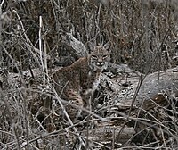 Bobcat in wintertime, at Almaden-Quicksilver Park
 -
 A deer in Ben Lomond
 -
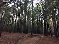 Coastal redwood forests near Santa Cruz.


There are two potential critical wildlife linkages which could enable species such as
Climate

The Santa Cruz Mountains have a Mediterranean type climate typical of most of California, with the majority of the annual precipitation falling between November and April. According to the National Weather Service, this totals more than 50 inches (127 cm) annually. Heavy summer fogs frequently cover the western ocean-facing slopes and valleys, resulting in drizzle and fog drip caused by condensation on the redwoods, pines, and other trees, which sustains the moisture-loving redwood forests. Due to a rain shadow effect, precipitation on the eastern side of the range is significantly less, about 25 inches (64 cm) a year. Snow falls a few times a year on the highest ridges, and more rarely the higher valleys receive light dustings.
The National Weather Service's cooperative weather stations in the mountains have included Black Mountain 2WSW – average annual rainfall 36.65 inches (931 mm), maximum annual rainfall 80.66 inches (2,049 mm), average annual snowfall 0.7-inch (18 mm), maximum annual snowfall 8.0 inches (200 mm); Los Gatos 5SW – average annual rainfall 26.45 inches (672 mm), maximum annual rainfall 103.23 inches (2,622 mm), average snowfall 2.7 inches (69 mm), maximum annual snowfall 9.0 inches (230 mm); and Wrights – average annual rainfall 46.09 inches (1,171 mm), maximum annual rainfall 87.65 inches (2,226 mm), average annual snowfall 1.2-inch (30 mm), maximum annual snowfall 10.6 inches (270 mm). No temperature records were kept at these stations.[16]
The Santa Cruz Mountains are subject to sharp diurnal temperature fluctuations. The highs and low within a 24-hour period are ~20–30 °F apart on average [17] but can be as much as 50 °F apart during heat waves depending on location. There is also considerable variation in temperature from day to day in both summer and winter with shifting wind directions, and fluctuations in the degree or marine influence.
Average winter highs range from the low 60s °F (~16–18 °C) [17] in the coastal valleys to the upper 50's °F (~14–15 °C) in the valleys further inland.[18] Average Winter overnight lows are a function of topography and can vary significantly, from an average low of 37 °F (~3 °C) [17] in the valleys to ~42–44 °F (~6–7 °C) [19] in the thermal belts above the inversion layer where cold air can readily drain off the slopes.
Summer temperatures regularly reach highs in the 80s °F (~28–30 °C)[17] with nighttime usually in the upper 40s to lower 60s °F (~9–18 °C) depending on elevation, distance from the ocean and degree of marine inversion present. Summer weather is dominated by a persistent marine layer that can vary in depth. When the inversion layer drops below 300–500 feet, the higher elevations are deprived of marine influence and will often be subject to intense heat waves with daytime temperatures in the 95–105 °F (~35–40 °C) range and extreme low humidity with elevated overnight lows that offer little relief from the heat. Such conditions can lead to fires that can occur even before the official State of California fire season starts. Examples of such fires include the 2016 Loma Fire, the 2009 Lockheed Fire and the Summit Fire in 2008.
Recreation

The Santa Cruz Mountains are home to an abundance of parks and protected open spaces, notable among them is California's oldest state park:
Cultural history

The previous historic
Film director Alfred Hitchcock and his wife Alma had their primary residence, the Cornwall Ranch, near Scotts Valley, purchased in September 1940.[22]
In 1965, science fiction author Robert A. Heinlein constructed a home in Bonny Doon, and lived there until shortly before his death in 1988.[23][24][25]
From 1970 to 2014, singer-songwriter Neil Young lived at Broken Arrow Ranch near Woodside with his family. Many of his songs from this time were recorded at the ranch.[26]
References
- ^ "Santa Cruz Mountains". Geographic Names Information System. United States Geological Survey, United States Department of the Interior. Retrieved 2009-05-03.
- ISBN 978-0-8047-1862-2.
- ^ "Morena Sierra". Geographic Names Information System. United States Geological Survey, United States Department of the Interior. Retrieved 2010-12-01.
- ISBN 978-0-8047-1862-2. Retrieved 2010-10-25.
- ^ Luther A. Ingersoll (1893). Henry D. Barrows (ed.). A memorial and biographical history of the coast counties of Central California. Lewis Publishing Company. p. 190. Retrieved 2010-10-25.
sierra morena san mateo county.
- ISBN 978-0-7432-4751-1.
- ^ Records, Hamilton Historical (2019-06-16). "The Formation Of The Santa Cruz Mountain Range". Hamilton Historical Records. Retrieved 2023-04-17.
- ^ James R. Griffin (September 1964). "A New Douglas-Fir Locality in Southern California". Forest Science: 317–319. Retrieved 2015-05-03.
- ^ a b Penrod, K.; P. E. Garding; C. Paulman; P. Beier; S. Weiss; N. Schaefer; R. Branciforte; K. Gaffney (2013). Critical Linkages: Bay Area & Beyond (PDF) (Report). Fair Oaks, California: Science & Collaboration for Connected Wildlands. Retrieved December 17, 2021.
- ^ Spencer, W.D.; P. Beier; K. Penrod; K. Winters; C. Paulman; H. Rustigian-Romsos; J. Strittholt; M. Parisi; A. Pettler (2010). California Essential Habitat Connectivity Project: A Strategy for Conserving a Connected California (Report). Sacramento, California: California Department of Transportation, California Department of Fish and Game, and Federal Highways Administration. Retrieved December 17, 2021.
- ^ a b Phillips, J.; R. Phillips; N. Srinivasan; D. Aso; W. Lao; P. Cornely (2012). Safe Passage for Coyote Valley - A Wildlife Linkage for the Highway 101 Corridor (PDF) (Report). Cupertino, California: Kirsch Center for Environmental Studies, De Anza College. Retrieved December 17, 2021.
- ^ "Mount Pajaro". Geographic Names Information System. United States Geological Survey, United States Department of the Interior.
- ^ "Pinecate Peak". Geographic Names Information System. United States Geological Survey, United States Department of the Interior.
- ^ Juan Reyes (September 14, 2020). "Rocks Ranch property sold to Land Trust". The Pajaronian. Retrieved December 17, 2021.
- ^ Rehn, Torstein (February 8, 2023). "Watch: Bobcat caught on camera using Highway 17 wildlife crossing". KSBW. Retrieved 2023-02-09.
- ^ "Central California". wrcc.dri.edu.
- ^ a b c d "BEN LOMOND 4, CALIFORNIA - Climate Summary". wrcc.dri.edu.
- ^ "LOS GATOS, CALIFORNIA - Climate Summary". wrcc.dri.edu.
- ^ "Personal Weather Station Dashboard | Weather Underground". www.wunderground.com.
- ^ "USDA Interactive Hardiness Map".
- ^ "ALMADEN VINEYARDS Historical Landmark". CA.gov. Office of Historic Preservation. 2010. Archived from the original on 2010-06-01.
- ^ "Hitchcock had Link to Santa Cruz Co". Archived from the original on September 5, 2007.
- ^ Caen, Herb (1988). "Robert A. Heinlein" (NNDB). San Francisco Chronicle.
- ^ "Heinlein Society Photo Tour of Bonny Doon". www.heinleinsociety.org. Archived from the original on 2004-04-02.
- ^ Google. "Heinleins' unique circular house on the east side of Bonny Doon Road just south of where Shake Mill Road dead-ends into Bonny Doon Road from the west" (Map). Google Maps. Google.
- ^ Carr, David (19 September 2012). "Neil Young Comes Clean". The New York Times.
External links
- Hiway17 – The Way Home Community website
- peaklist.org Santa Cruz Mountains ranked by prominence
- summitpost.org
- Santa Cruz Mountains on the Santa Cruz Wiki
