
Savaiʻi
Nickname: Soul of Samoa | |
|---|---|
Mt Matavanu (1905–1911) |
Savaiʻi is the largest and highest
Samoans sometimes refer to the island of Savaiʻi as Salafai: This is its classical Samoan name, and is used in formal oratory and prose. The island is home to 43,958 people (2016 census), and they make up 24% of the population of Samoa.[1] The island’s only
Savaiʻi is made up of six itūmālō (
The island is the largest
Society and culture


Samoan society is communal and based on extended family relationships and socio-cultural obligations, so that kinship and genealogies are important. These faʻa Sāmoa values are also associated with concepts of love (alofa), service (tautua) to family and community, respect (faʻaaloalo) and discipline (usitaʻi).[4] Most families are made up of a number of different households situated close to each other.
Like the rest of Samoa, Savaiʻi is made up of villages with most of the land
The Samoan language has a 'polite' and formal variant used in Samoan oratory and ceremony as well as in communication with elders, guests, people of rank and strangers. In all villages, the majority of people are largely sustained by plantation work and fishing[6] with financial assistance from relatives working in Apia or overseas. Most people live in coastal villages although there are some settlements inland such as the villages of Aopo, Patamea and Sili.
Behind the villages are cultivated plantations with crops of
.There is a church in every village, mostly Christian denominations.[7] Sunday is sacred and a day of rest as 98% of Samoans identify themselves as religious. White Sunday is one of the most important days of the year in Samoa when children are treated with special attention by their families and community.
History
World War II
During
In its present unprotected state, Western Samoa is a hazard of first magnitude for the defense of American Samoa. The conclusion is inescapable that if we don't occupy it the Japanese will and there may not be a great deal of time left.
—8 February 1943 Report on Western Samoa defence by 2nd Marine Brigade's intelligence officer, Lieutenant Colonel William L. Bales.[8]
On 18 May 1942 the 3rd Marine Brigade with 4,853 officers and men were on Upolu and Savaiʻi under the command of Brigadier General Charles D. Barrett.
1839 Wilkes Expedition

In October 1839, Savaiʻi and the
A great difference in form, physiognomy and manners...was observed here, as well as a change in the character of many articles of manufacture. The warclubs and spears were of uncommon form, and neatly made.
On 24 October, Wilkes writes, that the Porpoise arrived back at Sapapaliʻi village, having been gone nine days. The team met paramount chief Malietoa and his son at the village. With local guides Dr Pickering had travelled some way into the interior of the island, reaching one side of a volcanic crater about one thousand feet above the sea and some seven miles (11 km) inland.[9]
One 10 November 1839, the Wilkes Expedition weighed anchor at Apia and sailed westward, and on 11 November, had lost sight of Savaiʻi.

Notable places and people
- Archaeology in Samoa has uncovered prehistoric settlements inland in many parts of the island including sites at Sapapaliʻi village and Vailoa in Palaulidistrict.
- The exiled orator Lauaki Namulauulu Mamoe (died 1915), leader of the Mau a Pule, a resistance group against colonial rule in the early 1900s, was from the traditional sub-district of Safotulafai.
- The missionary John Williams (1796–1839) arrived in the village of Sapapaliʻi in 1830. Sapapaliʻi was also a base for the Malietoa title on Savaiʻi. A plaque by the main road in the village commemorates Williams' landing.
- In pre-history, the village of Tongans.
- Olaf Frederick Nelson, another exiled leader of the Mau movement in the 1920s, was born in Safune.
- The Pulemelei Mound in Palauli is the largest and most ancient structure in Polynesia.
- Pio Taofinuʻu (1923–2006), the first Polynesian cardinal and bishop, was from the village of Falealupo, Savaiʻi.
- Reverend George Pratt (1817–1894), a missionary of the London Missionary Society during the 1800s, lived in Matautu on the north coast. Pratt authored the first Samoan English language dictionary A Grammar and Dictionary of the Samoan Language, with English and Samoan Vocabulary, first printed in 1862.[10] Pratt's valuable dictionary records many old words of special interest–specialist terminology, archaic words and names in Samoan tradition. It contains sections on Samoan poetry and proverbs, and an extensive grammatical sketch.[11]
- Activist Leilua Lino is from Asau on the island. In 2019 she was presented with a Commonwealth Innovation for Sustainable Development Award by Prince Harry.[12][13]
Politics
With the country's independence in 1962, Samoa incorporates both traditional political structures alongside a western parliamentary system. The modern national Government of Samoa, based in the capital
Alongside Samoa's national and modern political structure is traditional authority vested in family chiefs (matai). The term Pule is applied to traditional authority in Savaiʻi.
The word Pule refers to appointments or authorities conferred on certain clans or individuals, sometime in the political history of Samoa. This traditional Pule authority was centred in certain villages around Savaiʻi. In the early 20th century, these Pule areas on Savaiʻi island were
In 1908, the 'Mau a Pule' resistance movement to colonial rule, which grew to become the national Mau movement, began on Savaiʻi and represented traditional authority against the German administration of Samoa. The equivalent term 'Tumua' is associated with traditional authority on Upolu island.
At the local level throughout Samoa, traditional authority is vested in a chiefs' council (fono o matai) in each village. The fono o matai carry out 'village law' and socio-political governance based on their traditional authority and faʻa Samoa. The authority of the matai is balanced against central government, the Malo. Most of the matai are males, however, the women in each village also have a voice in domestic affairs through the women's committees.

The main government administration offices of the Malo on Savaiʻi are situated in the village of Tuasivi, 10 minutes north of the ferry terminal and market at Salelologa. There's a district hospital, police station, post office and court houses in Tuasivi.
Vaʻai Kolone, a matai and businessman from Vaisala, at the west end of the island, became the Prime Minister of Samoa twice in the 1980s.
Samoa has 11 political districts (itūmālō) and 6 are in Savaiʻi; Faʻasaleleaga, Gagaʻemauga, Gagaʻifomauga, Palauli, Satupaʻitea and Vaisigano.
Scenery and landscape

Savaiʻi is mountainous, fertile and surrounded by coral reefs.
Myths and legends

Rich in Polynesian history and oral tradition, Savaiʻi is mentioned in myths and legends across the
Savaiʻi is known as the "Soul of Samoa." "Here the 20th century has put down the shallowest roots, and the faʻa Samoa—the Samoan way—has the most meaning."[24]
Flora and fauna

Flora
The tropical climate and fertile soil results in a variety of flora. Vegetation types include littoral, wetland and volcanic vegetation.
The variety of tropical plant life is also a material source for floral adornment,
Fauna

Animal species include fruit bats such as the
Samoa has more native species of ferns and butterflies than New Zealand, a country 85 times larger.[30] In 2006, research samples of the blue moon butterfly species (Hypolimnas bolina) on Savaiʻi found that males accounted for just 1% of the population and had almost been wiped out by an invasive species. Sampling a year later showed a dramatic comeback and recovery to 40%.[31]
The surrounding Pacific Ocean, coral reefs and lagoons are rich in marine life and some are harvested as an important source of food in an economy that is mainly subsistence with locals reliant on the land and the ocean for survival. Dolphins, whales and porpoises migrate through Samoa's waters.[32] The
Surrounded by a variety of tropical fauna, Samoan mythology is rich with stories of animals incorporated into their culture, traditional beliefs and way of life.
Conservation
The island is rich in
Travel information

Ferry terminal
Driving
Savaiʻi has an excellent tar-seal road circling the island. A leisurely drive around the island takes under 3 hours. The scenic drive is mostly along the coastline where most of the locals live in villages. Driving in Samoa is on the left side of the road, effective from 7 September 2009 when the government changed the law to bring motoring in line with neighbouring countries. Samoa is the first country in the 21st century to switch to driving on the left.[34]
Airport

Maota Airport is a small airstrip with basic facilities situated 10-minutes south of Salelologa ferry terminal and township. Flights operate between Maota and Asau airstrip and Faleolo International Airport on Upolu. The inter-island flights take about 30-minutes.[35] Asau Airport is an airstrip at the north west end of the island which mainly services chartered flights.[36]
Amenities
A local market (open Monday – Saturday) at Salelologa sells fresh produce of fruit, vegetables and local crafts. There are also clothing stores, several small supermarkets, a wholesaler, petrol stations, bakeries, budget hotels and accommodation,[37] buses, taxis, rental car companies as well as public amenities such as internet access, banks and Western Union money transfer outlets. There are small local shops in every village around Savaiʻi, selling basic groceries. Markets and most shops in Samoa close on Sundays with smaller outlets opening late afternoon after church services.
Hospitals
The main hospital on Savaiʻi is the Malietoa Tanumafili II Hospital, situated in Tuasivi village.[38] Another district hospital is in Safotu, on the central north coast.
Tourism


Cultural context
With most of the land in Samoa under
The last sunset in the world
The village of Falealupo on the westernmost point of Savaiʻi, is just 20 miles (32 km) from the dateline. It was arguably the last place in the world to see the sunset until a time zone change at end of 2011.[40] Falealupo was the site of Millennium 2000 celebrations and reported by the BBC as 'the last place on earth to enter the new millennium.'[41] Falealupo also has protected rainforests.
Surfing
Savaiʻi has
Tourism development
In 2008, an American company South Pacific Development Group (SPDG) obtained a 120-year lease for 600 acres (2.4 km2) of prime oceanfront customary land in
The announcement of the tourist development raised concern among environmental group O Le Siʻosiʻomaga Society about the impact of the development.[46] The Samoa Hotel Association also expressed concern at the size of the development and its impact on the island's environment and infrastructure.[47] The development is supported by the Government of Samoa. The lease is unprecedented in Samoa where 80% of the land is under customary ownership, 6% freehold and the rest owned by the government.[48]
Film

Moana (1926), one of the earliest documentaries made in the world, was filmed in Safune on the central north coast. The film was directed by Robert J. Flaherty who lived with his wife and children in Safune for more than a year. A cave with a pool in Safune was converted into a film processing laboratory and two young men from the village were trained to work there. Flaherty cast people from Safune in the film including local boy Taʻavale who played the lead role of 'Moana'. Another boy called Peʻa played the role of Moana's younger brother. Peʻa later became a chief with the title Taulealeausumai from the village of Faletagaloa. Playing the lead female role in the film was Faʻagase, a girl from Lefagaoaliʻi. The film also showed the young hero 'Moana' receiving a peʻa, a traditional Samoan tattoo.
Geography

-1.svg)
Savaiʻi island lies north west of Upolu. These two largest islands of Samoa are separated by the Apolima Strait which is about 8 miles (13 km) wide with the small inhabited islands of Manono and Apolima between them. Savaiʻi island is of volcanic origin and the mountainous interiors are covered with dense rain forests. The surrounding landscape consists of fertile plateaux and coastal plains with numerous rivers and streams.
Climate

The climate is oceanic tropical with high temperatures and humidity. The heaviest rainfall occurs between the months of November and April, and cyclones, which are relatively frequent, are most likely to occur during these same months.[25] Two cyclones, Cyclone Ofa (1990) and Cyclone Valerie (1991)[49] caused extensive damage on the north and west coast of Savaiʻi.
Geology
Savaiʻi is the largest shield volcano in the South Pacific[50] and only 3% is above water.[51] It is an
Pre-historic geological formations on SavaiʻI have created natural sites such as the
Volcanic activity
The island consists of a large shield volcano similar in form to the Hawaiian volcanoes. Savaiʻi remains volcanically active, with recent eruptions from Matavanu between 1905 and 1911. The Matavanu eruptions flowed towards the central north coast and destroyed villages including Saleaula. Other recent volcanic eruptions include Mata o le Afi in 1902 and Mauga Afi in 1725. The lava field at Saleaula are extensive enough to be visible in high altitude photographs.[55]
Education
Samoa education system
Like the rest of the country, the education system on Savaiʻi is mostly
schooling in villages. Education in Samoa is compulsory for children aged 5-years to 14-years or until the completion of Year 8.- Primary education – Year 1 – 8 (8-years)
- Secondary education – Year 9 – 13 (5-years)
Entrance to secondary education is determined by a National Examinination at Year 8. Top achievers in government schools can enter
Cost
Village responsibility
In both primary and secondary schools across Samoa, villages are responsible for school buildings, equipment, furniture, fundraising and collection of school fees.
Government responsibility
The government is responsible for teachers, curriculum and educational materials as well as assessments and exams administered under the Ministry of Education, Sports and Culture.[58] The government also employs School Review Officers who are the main liaison with schools.
International aid
The government receives international aid for education from countries such as
Tertiary education
Most opportunities for tertiary education in the country are available on Upolu island, the location of the National University of Samoa and the Alafua Campus of the regional University of the South Pacific. International volunteer programmes including the American Peace Corps also provide teachers throughout schools in Savaiʻi and the rest of the country.
School calendar

| School Terms | Dates | Duration |
|---|---|---|
| Term 1 | 1 February – 15 May | (15 weeks) |
| Term 2 | 7 June – 3 September | (13 weeks) |
| Term 3 | 20 September – 10 December | (12 weeks) |
| School holidays | 2010 dates |
|---|---|
| 15 May – 6 June | |
| 5–19 September | |
| 11 December – 30 January |
List of schools in Savaiʻi
There are 9 secondary schools and 48 primary schools on the island.[62]
Public library
Savaiʻi Public Library is the only public library on the island. It is situated by the old market in the township of Salelologa at the east end of Savaiʻi. The library is a branch of the central Samoa Public Library in the capital Apia on Upolu island.[63]
Public holidays
Public holidays;[56]
| Holiday | Date |
|---|---|
| Good Friday | Varies |
| Easter Monday | Varies |
| Mother's Day | 10 May |
| Samoa Independence Day | 1 June (celebrations) |
| Father's Day | 9 August |
| White Sunday (2nd Sunday of October) | Varies |
| Christmas Day | 25 December |
| Boxing Day | 26 December |
Samoa gained political independence from New Zealand on 1 January 1962. However, independence celebrations take place on 1 June, each year.[64]
Gallery
-
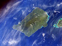 Savaiʻi island from space (NASA photo)
 -
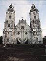 Historic church in Safotu village.
 -

-
 View from Pulemelei Mound
 -
 Mu Pagoa Waterfall in Palauli district.
 -
 Stone church in Satupaʻitea on Savaiʻi c. 1908
 -
 Local bus
 -
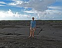 Lava fields on Savaiʻi
 -
 Sunset at Sapapaliʻi
 -
 Samoa fire dance siva afi
 -
 Beach fale, popular in eco-tourism in villages around the coast.
 -
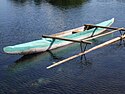 Fishing canoe (vaʻa) with small outrigger
 -
 View from the ferry with tiny Apolima island and Savaiʻi coast (right).
 -
 Mount Matavanu volcano, 1906
 -
 Breadfruit tree (Artocarpus altilis), a staple food in Samoa.
 -
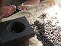 Roast coacoa koko beans grown locally for hot Samoan koko drink.


.Andrew.Thomas_1906.jpg)


See also
- Archaeology in Samoafor archaeology on Savaiʻi
- Architecture of Samoa
- Districts of Samoa (political districts)
- Culture of Samoa
- Samoa Islands
- Samoan language
- Samoa Tourism Authority
References
- ^ a b c "Final Population and Housing Census 2006". Samoa Bureau of Statistics. July 2008. Archived from the original on 1 January 2011.
- ISBN 978-982-02-0029-6. Retrieved 26 July 2014.
- ^ a b "Priority Sites for Con-servation in Samoa: Key Biodiversity Areas" (PDF).
- ^ 3. Culture and identity – Samoans – Te Ara Encyclopedia of New Zealand Faʻa Sāmoa, Samoan culture, New Zealand Encyclopaedia Archived 2 November 2012 at the Wayback Machine
- ISBN 978-0-306-47770-6. Retrieved 26 July 2014.
- ^ "Gagaemauga 3 District: Community-based Adaptation for Gagaemauga 3 District | Adaptation Learning Mechanism". adaptationlearning.net. Archived from the original on 7 January 2011.
- ^ CHAPTER V — A Samoan Village | NZETC An Introduction to Samoan Custom by F.J.H. Grattan, Chapter V, A Samoan Village, p. 53 Archived 23 December 2010 at the Wayback Machine
- ^ "THE SAMOAN HISTORICAL CALENDAR, 1606–2007" (PDF). p. 37. Archived from the original (PDF) on 28 December 2016.
- ^ Wilkes, Charles (1849). Narrative of the United States Exploring Expedition During the Years 1838, 1839, 1840, 1841, 1842. C. Sherman. p. 110.
- ISBN 978-2-8254-0692-2. Retrieved 26 July 2014.
- ^ Pratt, George. "Title: A Grammar and Dictionary of the Samoan Language, with English and Samoan vocabulary, NZ Licence CC-BY-SA 3.0". NZ Electronic Text Centre, Victoria University of Wellington. Archived from the original on 18 March 2012. Retrieved 5 December 2009.
- ^ "Duke of Sussex presents innovation awards at Commonwealth 70th anniversary garden party | The Commonwealth". 11 April 2021. Archived from the original on 11 April 2021. Retrieved 28 October 2021.
- ^ "The journey of a survivor – Leilua receives Commonwealth Innovation award". ECPAT. 9 July 2019. Retrieved 28 October 2021.
- ^ Tumua and Pule. — Construction and significance in the Political history of Samoa | NZETC An Account of Samoan History up to 1918 by Teʻo Tuvale, NZ Licence CC-BY-SA 3.0, NZ Electronic Text Centre. Retrieved 31 October 2009 Archived 30 March 2012 at the Wayback Machine
- ISBN 978-982-02-0390-7. Retrieved 26 July 2014.
- ^ "Samoa." The Columbia Encyclopedia, Sixth Edition. 2008. Encyclopedia.com. 3 Oct. 2009 [1]
- ^ "Introducing Savai'i". www.lonelyplanet.com. Archived from the original on 13 April 2014.
- ^ "Savaiʻi | island, Samoa". Encyclopædia Britannica. Archived from the original on 13 October 2013.
- ^ a b "Where the wild things blow". The Sydney Morning Herald. 28 June 2009. Archived from the original on 4 November 2012.
- ^ "Samoa: History". www.pacificislandtravel.com. Archived from the original on 18 February 2012.
- ISBN 978-0-8248-3224-7. Retrieved 26 July 2014.
- ISBN 978-1-4068-3371-3. Retrieved 26 July 2014.
- ^ "Living Heritage -Marcellin College – Sina and the Eel". livingheritage.org.nz. Archived from the original on 29 October 2012.
- ^ Robert Booth, "The two Samoas still coming of age," in National Geographic Magazine, Vol. 168, No. 4, October 1985, p. 469
- ^ a b "FAO Workshop – Data Collection for the Pacific Region – FRA WP 51". fao.org. Archived from the original on 9 June 2013.
- ^ "Savaiʻi, Western Samoa, as a Pacific-Asia Biodiversity (PABITRA) Transect Site". Archived from the original on 13 July 2011. Retrieved 18 October 2009.
- ^ [2] Government of Samoa, 1998
- ^ Ministry of Natural Resources and Environment – Latest Articles Module Samoa Government Ministry of Natural Resources
- ^ "Species factsheet". Birdlife International. 2010. Archived from the original on 30 June 2007.
- ^ James Atherton, ed. (2010). "Report:Vaega Faʻatauainamole Faʻasaoi Samoa, Priority Sites for Con-servation in Samoa: Key Biodiversity Areas" (PDF). Conservation International – Pacific Islands Programme, Samoa Ministry of Natural Resources and Environment, Secretariat of the Pacific Regional Environment Programme.
- ^ "Samoan butterflies evolving fast". Discovery Channel News. 12 July 2007. Archived from the original on 12 October 2012.
- ^ "SAMOA ONLINE". wsamoa.ws. Archived from the original on 27 February 2012.
- ^ [3] Report to the Convention of Biological Diversity, Government of Samoa, 1998
- ^ "Samoa switches to driving on left". BBC News. 7 September 2009. Archived from the original on 5 August 2011.
- ^ "SavaiʻI Guide Overview". Archived from the original on 3 July 2009. Retrieved 22 September 2009.
- ^ [4] South Pacific Regional Environment Programme (SPREP), 21-7-2007. Retrieved 26 October 2009
- ^ "WEBSITE.WS – Your Internet Address For Life™". mysamoatours.ws. Archived from the original on 12 December 2013.
- ^ [5] Medicine Uncharted Organisation. Retrieved 25 April 2010 Archived 13 September 2009 at the Wayback Machine
- ^ [6], Beach Fales:Sustainable Eco-Tourism and Cultural Preseravation in Samoa by Rachel Rasela Dolgin]
- ^ "Samoa to move the International Dateline". Herald Sun. 7 May 2011. Archived from the original on 2 May 2016.
- ^ "Global party reaches Hawaii". BBC News. 1 January 2000.
- ^ "Samoa A-Z Visitors Guide – safety, Samoa, Savaiʻi, Saʻmoana beach resort, scuba diving, shopping, sinalei reef resort & spa, siufaga beach resort, siva, smoking, sport & recreation, squash, stevenson, suicide, sun protection, sundays, supermarkets, surfing, swimming". Samoa A-Z Visitors Guide. Archived from the original on 3 March 2013.
- ^ "Satui'atua Beach Fales". samoa-hotels.com. Archived from the original on 25 July 2012.
- ^ "Samoa, an investment opportunity". South Pacific Development Group LLC. Archived from the original on 8 March 2012. Retrieved 6 July 2010.
- ^ Senara Brown, Alan Ah Mu (16 March 2010). "Casino warning". Samoa Observer. Archived from the original on 5 March 2012.
- ^ "SAVAII RESORT PROPOSAL RAISES CONCERN". Pacific Islands Report. 11 July 2008. Retrieved 6 February 2021.
- ^ "Samoa Hotel Association worried about size of Savaii project". RNZ. 10 July 2008. Retrieved 6 February 2021.
- ^ "Samoa department warns that sale of customary land is illegal". RNZ. 15 May 2002. Retrieved 6 February 2021.
- ^ "Samoa". U.S. Department of State.
- ISBN 978-0-313-31395-0. Retrieved 26 July 2014.
- ^ a b "Samoa Found To Be in Path of Geological Hotspots, Adding Fuel To Debate Over Origins of Volcanic Chains". Science Daily. Adapted from materials provided by Oregon State University. 17 June 2008. Archived from the original on 14 May 2013.
- ^ Lippsett, Laurence (3 September 2009). "Voyage to Vailuluʻu". Woods Hole Oceanographic Institution. Archived from the original on 6 March 2014.
- Bibcode:2006AGUFM.V34B..02K.
- ISSN 1525-2027. Archived from the original(PDF) on 29 February 2004.
- ^ "Savaiʻi". Archived from the original on 23 December 2010. Retrieved 23 December 2010. at OceanDots.com
- ^ a b "2010 School Calendar". Samoa Ministry of Education, Sports & Culture. Archived from the original on 12 February 2013. Retrieved 27 May 2010.
- ^ "Falealupo matai defend Nafanua Cox". Samoa Observer. 25 January 2009. Archived from the original on 5 March 2012.
- ^ "Strategic Policies and Plan, July 2006 – June 2015". Samoa Ministry of Education, Sports & Culture. 30 June 2006.
- ^ a b "Aid activities in Samoa". Government of Australia. Archived from the original on 6 March 2012. Retrieved 27 August 2010.
- ^ "NZAID Samoa". New Zealand Government. Archived from the original on 20 August 2010. Retrieved 27 August 2010.
- ^ "Activities in Samoa". Japan International Cooperation Agency. Archived from the original on 8 March 2012. Retrieved 27 August 2010.
- ^ "Savaiʻi Schools". Samoa Ministry of Education, Sports & Culture. Archived from the original on 20 December 2013. Retrieved 27 May 2010.
- ^ "History of Libraries in Samoa". Library Association of Samoa. Archived from the original on 27 November 2013. Retrieved 27 May 2010.
- ^ "Celebrations of Samoa's Independence Day". Te Ara Encyclopedia of New Zealand. Archived from the original on 20 October 2012. Retrieved 30 May 2010.
External links
- Building a 3D model for land-use and nature conservation planning, Savaii Island, Samoa; Rudolf Hahn CTA FAO 2015 youtube video
- Looking for the Manumea. An ecological survey in community conservation areas, Savaii Island, Samoa; Rudolf Hahn CTA FAO 2014 youtube video
- "Savaiʻi". Global Volcanism Program. Smithsonian Institution.
13°35′S 172°25′W / 13.583°S 172.417°W
- Final 2006 Samoa Census Report, Samoa Bureau of Statistics, July 2008
- Savaii Samoa Tourism Association
- Samoa Tourism Authority
- Sydney Morning Herald travel article June 2009
- Surfing Samoa on Youtube
- The Samoan Historical Calendar 1606 – 2007 by Stan Sorensen, Historian, Office of the Governor, American Samoa & Joseph Theroux
- First Samoan dictionary, 3rd edition (1893) by Rev. George Pratt
- Library Association of Samoa website
| International | |
|---|---|
| National | |
| Geographic | |
| Other | |