
Scandinavian Mountains
| Scandinavian Mountains | |
|---|---|
 | |
| Highest point | |
| Peak | Galdhøpiggen, Lom |
| Elevation | 2,469 m (8,100 ft)[1] |
| Coordinates | 61°38′11″N 08°18′45″E / 61.63639°N 8.31250°E |
| Dimensions | |
| Length | 1,700 km (1,100 mi)[2] |
| Width | 320 km (200 mi)[2] |
| Naming | |
| Native name | Skanderna, Fjällen, Fjellet, Kjølen, Köli, Skandit (Swedish) |
| Geography | |
 The Scandinavian Mountains
| |
| Countries | |
| Range coordinates | 65°N 14°E / 65°N 14°E |
The Scandinavian Mountains or the Scandes is a
The mountains are relatively high for a range so young and are very steep in places; Galdhøpiggen in South Norway is the highest peak in mainland Northern Europe, at 2,469 metres (8,100 ft); Kebnekaise is the highest peak on the Swedish side, at 2,104 m (6,903 ft), whereas the slope of Halti is the highest point in Finland, at 1,324 m (4,344 ft), although the peak of Halti is situated in Norway.
The
Its names in the Scandinavian languages are, in
Orography
The mountain chain's highest summits are mostly concentrated in an area (of

To the east, the Scandinavian Mountains proper bounds with mountains that are lower and less dissected and are known in Swedish as the förfjäll (literally 'fore-fell'). Generally the förfjäll do not surpass 1,000 m above sea level. As a geomorphic unit the förfjäll extends across Sweden as a 650 km long and 40 to 80 km broad belt from Dalarna in the south to Norrbotten in the north. While lower than the Scandinavian Mountains proper, the förfjäll's pronounced relief, its large number of plateaux, and its coherent valley system distinguish it from so-called undulating hilly terrain (Swedish: bergkullsterräng) and plains with residual hills (Swedish: bergkullslätt) found further east.[17]
Climate, permafrost and glaciers

The climate of the Nordic countries is maritime along the coast of Norway, and much more continental in Sweden in the rain shadow of the Scandinavian Mountains. The combination of a northerly location and moisture from the North Atlantic Ocean has caused the formation of many ice fields and glaciers. In the mountains, the air temperature decreases with increasing altitude, and patches of mountain permafrost in regions with a mean annual air temperature (MAAT) of -1.5 °C will be found at wind exposed sites with little snow cover during winter. Higher up, widespread permafrost may be expected at altitudes with a MAAT of -3.5 °C, continuous permafrost at altitudes with a MAAT of -6.0 °C.[18]
Within the EU-sponsored project PACE (Permafrost and Climate in Europe), a 100 m deep borehole was drilled in bedrock above Tarfala research station at an altitude of 1540 m above sea level. The stable ground temperature at a depth of 100 meters is still -2.75 °C.[19] The measured geothermal gradient in the drillhole of 1.17 °C /100 m allows to extrapolate a permafrost thickness of 330 meters, a further proof that continuous permafrost exists in these altitudes and above, up to the top of Kebnekaise.
In the Scandinavian Mountains, the lower limit of widespread discontinuous permafrost drops from 1700 meters in the west of southern Norway to 1500 meters near the border with Sweden, and from 1600 m in northern Norway to 1100 m in northern, more continental Sweden (Kebnekaise area).[20] In contrast to the lower limit of permafrost, the mean glacier altitude (or glaciation limit) is related to the amount of precipitation. Thus the snow line, or glacier equilibrium line as the limit between the accumulation zone and ablation zone shows the opposite trend, from 1500 meters in the west (Jostefonn) to 2100 meters in the east (Jotunheimen).
Geology
Bedrock

Most of the rocks of the Scandinavian Mountains are Caledonian, which means they were put in place by the
While there are some disagreements, geologists generally recognize four
It was during the Silurian and
Origin
The origin of today's mountain topography is debated by geologists.
The various episodes of uplift of the Scandinavian Mountains were similar in orientation and tilted land surfaces to the east while allowing
Unlike orogenic mountains, there is no widely accepted geophysical model to explain elevated passive continental margins such as the Scandinavian Mountains.[40] Various mechanisms of uplift have, however, been proposed over the years. A 2012 study argues that the Scandinavian Mountains and other elevated passive continental margins most likely share the same mechanism of uplift and that this mechanism is related to far-field stresses in Earth's lithosphere. The Scandinavian Mountains can according to this view be likened to a giant anticlinal lithospheric fold. Folding could have been caused by horizontal compression acting on a thin to thick crust transition zone (as are all passive margins).[41][42]
Alternative lines of research have stressed the
Quaternary geology
Many slopes and valleys are straight because they follow tectonic

The
Highest mountains
Norway
Of the 10 highest mountain peaks in Scandinavia (
- 2,469 m (8,100 ft) Galdhøpiggen (Innlandet)
- 2,465 m (8,087 ft) Glittertind (Innlandet)
- 2,405 m (7,890 ft) Store Skagastølstind (Vestland)
- 2,387 m (7,831 ft) Store Styggedalstinden east (Vestland)
- 2,373 m (7,785 ft) Skarstind (Innlandet)
- 2,369 m (7,772 ft) Vesle Galdhøpiggen (Innlandet)
- 2,368 m (7,769 ft) Surtningssue (Innlandet)
- 2,366 m (7,762 ft) Store Memurutinden (Innlandet)
- 2,351 m (7,713 ft) Jervvasstind (Vestland)
- 2,348 m (7,703 ft) Sentraltind (Vestland)
| Part of a series on |
| Scandinavia |
|---|
 |
-
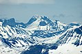 Galdhøpiggen seen from west, Norway's highest mountain
 -
-

-
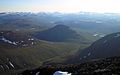 Landscape between Abisko National Park and Kebnekaise


Sweden
There are 12 peaks in
- 2,104 m (6,903 ft) Lappland) – Note: Altitude includes the peak glacier. If melting continues, Kebnekaise Nordtoppen, just 500 meters away and 7 meters lower, might become the highest point.
- 2,097 m (6,880 ft) Kebnekaise Nordtoppen (Lappland) – the highest fixed point in Sweden.
- 2,089 m (6,854 ft) Sarektjåkkå Stortoppen (Lappland)
- 2,076 m (6,811 ft) Kaskasatjåkka (Lappland)
- 2,056 m (6,745 ft) Sarektjåkkå Nordtoppen (Lappland)
- 2,043 m (6,703 ft) Kaskasapakte (Lappland)
- 2,023 m (6,637 ft) Sarektjåkkå Sydtoppen (Lappland)
- 2,016 m (6,614 ft) Akka Stortoppen (Lappland)
- 2,010 m (6,594 ft) Akka Nordvästtoppen (Lappland)
- 2,010 m (6,594 ft) Sarektjåkkå Buchttoppen (Lappland)
- 2,005 m (6,578 ft) Pårtetjåkka (Lappland)
- 2,002 m (6,568 ft) Palkatjåkka (Lappland)
Other popular mountains for skiers, climbers and hikers in Sweden
- Sulitelma 1,860 m (Lappland)
- Helagsfjället 1,796 m (Härjedalen)
- Norra Storfjället 1,767 m (Lappland)
- Templet 1,728 m (Jämtland)
- Lillsylen 1,704 m (Jämtland)
- Åreskutan 1,420 m (Jämtland)
- Storvätteshågna 1,204 m (Dalarna)
- Nipfjället 1,191 m (Dalarna)
- Städjan 1,131 m (Dalarna)
Finland

- 1,324 m (4,344 ft) Halti (Lappi/Lapland and Norwegian Troms)
- 1,317 m (4,321 ft) Ridnitsohkka(Lappi/Lapland)
- 1,280 m (4,200 ft) Kiedditsohkka (Lappi/Lapland)
- 1,240 m (4,068 ft) Kovddoskaisi (Lappi/Lapland)
- 1,239 m (4,065 ft) Ruvdnaoaivi (Lappi/Lapland)
- 1,180 m (3,871 ft) Loassonibba (Lappi/Lapland)
- 1,150 m (3,773 ft) Urtasvaara (Lappi/Lapland)
- 1,144 m (3,753 ft) Kahperusvaarat (Lappi/Lapland)
- 1,130 m (3,707 ft) Aldorassa (Lappi/Lapland)
- 1,100 m (3,608 ft) Kieddoaivi (Lappi/Lapland)
See also

Notes
- ^ The two high areas, north and south of Trondheim, have been usually referred to as "domes" but technically they are not geological domes.[9]
- glacial valleys. The other half is made up of coastal mountains and intermediate-relief glacial valleys.[14]
- ^ After being first described by Hans Reusch in 1901 the Paleic surface was subject of various interpretations in the 20th century.[23][28]
- ^ Tormod Klemsdal regard the strandflat as old surfaces shaped by deep weathering that escaped the uplift that affected the Scandinavian Mountains,[35] a view concordant with a Triassic (c. 210 million years ago) origin for the strandflat postulated in the 2010s by Odleiv Olesen, Ola Fredin and their respective co-workers.[36][37] Yet Hans Holtedahl claimed in 1998 that strandflats formed after a Tertiary uplift the mountains noting however that in Trøndelag between Nordland and Western Norway the strandflat could be a surface formed before the Jurassic, then buried in sediments and at some point freed from this cover.[38] Haakon Fossen and co-workers added to the debate in 2017 that movement of geological faults in the Late Mesozoic should imply the strandflats of Western Norway took their final shape after the Late Jurassic or else they would occur at various heights above sea level.[39]
- ^ These are the Northern Patagonian Ice Field, Southern Patagonian Ice Field and the Gran Campo Nevado.
References
- ^ "Galdhøpiggen". Nationalencyklopedin (in Swedish). Retrieved 18 July 2010.
- ^ a b Lindström, Maurits. "fjällkedjan". Nationalencyklopedin (in Swedish). Retrieved 18 July 2010.
- ^ "- Nordryggen, hæ ?" [The North Ridge, what]. Dagbladet (in Norwegian). 14 September 2013.
- ^ "Geo365 – Nordryggen: Rotfestet i norsk navnetradisjon". www.geo365.no.
- ^ TT (14 September 2013). "Fjällen får nytt norskt namn – SvD". Svenska Dagbladet.
- ^ Radio, Sveriges (14 September 2013). "Norge namnger fjällen – kallar dem Nordryggen – Nyheter (Ekot)". Sveriges Radio.
- ^ "The delineation of European mountain areas" (PDF). Mountain Areas in Europe – Final Report. European Commission. p. 27. Retrieved 4 November 2016.
- ^ a b c d e f Rudberg, Sten (1960). "Geology and Morphology". In Somme, Axel (ed.). Geography of Norden. Heinemann. pp. 27–40.
- doi:10.1130/B30691.1.
- ^ Askheim, Svein (14 December 2017). "Den skandinaviske fjellkjede" – via Store norske leksikon.
- ^ S2CID 129912355.
- .
- ^ ISBN 978-0-19-924590-1.
- ^ Etzelmüller, Bernd; Romstad, Bård; Fjellanger, Jakob (2007). "Automatic regional classification of topography in Norway". Norwegian Journal of Geology. 87: 167–180.
- ^ doi:10.1130/g34806.1.
- S2CID 246564493.
- ^ Terrängformer i Norden (in Swedish). Nordiska ministerrådet. 1984. p. 10.
- .
- .
- ^ King, Lorenz (1983). "High Mountain Permafrost in Scandinavia". Permafrost: Fourth International Conference, Proceedings: 612–617.
- ^ ISBN 978-91-44-05847-4.
- ^ .
- ^ . Retrieved 30 April 2015.
- ^ S2CID 55985869.
- ^ .
- ^ .
- ^ .
- .
- ^ Lidmar-Bergström, Karna. "Paleiska ytan". Nationalencyklopedin (in Swedish). Cydonia Development. Retrieved 22 June 2015.
- .
- ^ a b Lidmar-Bergström, K.; Näslund, J.O. (2002). "Landforms and uplift in Scandinavia". In Doré, A.G.; Cartwright, J.A.; Stoker, M.S.; Turner, J.P.; White, N. (eds.). Exhumation of the North Atlantic Margin: Timing, Mechanisms and Implications for Petroleum Exploration. Geological Society, London, Special Publications. The Geological Society of London. pp. 103–116.
- S2CID 134575021.
- ^ doi:10.1130/B30691.1.
- hdl:1871/8356.
- ISBN 978-1-4020-3880-8.
- ^ Olesen, Odleiv; Kierulf, Halfdan Pascal; Brönner, Marco; Dalsegg, Einar; Fredin, Ola; Solbakk, Terje (2013). "Deep weathering, neotectonics and strandflat formation in Nordland, northern Norway". Norwegian Journal of Geology. 93: 189–213.
- PMID 28452366.
- ^ Holtedahl, Hans (1998). "The Norwegian strandflat puzzle" (PDF). Norsk Geologisk Tidsskrift. 78: 47–66.
- PMID 29138403.
- ^ Bonow, Johan M. (2009). "Atlantens kustberg och högslätter – gamla eller unga?" (PDF). www.geografitorget.se (in Swedish). Geografilärarnas Riksförening.
- .
- ^ Løseth and Hendriksen 2005
- ^ Nielsen, S.B.; Paulsen, G.E.; Hansen, D.L.; Gemmer, L.; Clausen, O.R.; Jacobsen, B.H.; Balling, N.; Huuse, M.; Gallagher, K. (2002). "Paleocene initiation of Cenozoic uplift in Norway". In Doré, A.G.; Cartwright, J.A.; Stoker, M.S.; Turner, J.P.; White, N. (eds.). Exhumation of the North Atlantic Margin: Timing, Mechanisms and Implications for Petroleum Exploration. Geological Society, London, Special Publications. The Geological Society of London. pp. 103–116.
- ^ .
- .
- hdl:1956/11701.
External links
![]() Media related to Scandinavian Mountains (range) at Wikimedia Commons
Media related to Scandinavian Mountains (range) at Wikimedia Commons
| Authority control databases: National |
|---|