
Scottish Highlands
Highlands
A' Ghàidhealtachd ( | |
|---|---|
 Lowland–Highland divide | |
| Seat | Inverness |
| Population | |
| • Estimate (2019) | 600,000 |
| [citation needed] | |
| Demonym | Highlander |
| Time zone | GMT/BST |
The Highlands (

The area is very sparsely populated, with many mountain ranges dominating the region, and includes the highest mountain in the British Isles, Ben Nevis. During the 18th and early 19th centuries the population of the Highlands rose to around 300,000, but from c. 1841 and for the next 160 years, the natural increase in population was exceeded by emigration (mostly to Canada, the United States, Australia and New Zealand, and migration to the industrial cities of Scotland and England.)[2]: xxiii, 414 and passim The area is now one of the most sparsely populated in Europe. At 9.1/km2 (24/sq mi) in 2012,[3] the population density in the Highlands and Islands is less than one seventh of Scotland's as a whole.[3]
The
The Scottish Highlands is the only area in the British Isles to have the
.History
Culture


Between the 15th century and the mid-20th century, the area differed from most of the
Historically, the major social unit of the Highlands was the
Older historiography attributes the collapse of the clan system to the aftermath of the
Economy
Recurrent famine affected the Highlands for much of its history, with significant instances as late as 1817 in the Eastern Highlands and the early 1850s in the West.[2]: 415–16 Over the 18th century, the region had developed a trade of black cattle into Lowland markets, and this was balanced by imports of meal into the area. There was a critical reliance on this trade to provide sufficient food, and it is seen as an essential prerequisite for the population growth that started in the 18th century.[2]: 48–49 Most of the Highlands, particularly in the North and West was short of the arable land that was essential for the mixed, run rig based, communal farming that existed before agricultural improvement was introduced into the region.[a] Between the 1760s and the 1830s there was a substantial trade in unlicensed whisky that had been distilled in the Highlands. Lowland distillers (who were not able to avoid the heavy taxation of this product) complained that Highland whisky made up more than half the market. The development of the cattle trade is taken as evidence that the pre-improvement Highlands was not an immutable system, but did exploit the economic opportunities that came its way.[11]: 24 The illicit whisky trade demonstrates the entrepreneurial ability of the peasant classes.[10]: 119–34
Agricultural improvement reached the Highlands mostly over the period 1760 to 1850. Agricultural advisors,
In the West and North, evicted tenants were usually given tenancies in newly created crofting communities, while their former holdings were converted into large sheep farms. Sheep farmers could pay substantially higher rents than the run rig farmers and were much less prone to falling into arrears. Each croft was limited in size so that the tenants would have to find work elsewhere. The major alternatives were fishing and the kelp industry. Landlords took control of the kelp shores, deducting the wages earned by their tenants from the rent due and retaining the large profits that could be earned at the high prices paid for the processed product during the Napoleonic wars.[18]: 1–12
When the Napoleonic wars finished in 1815, the Highland industries were affected by the return to a peacetime economy. The price of black cattle fell, nearly halving between 1810 and the 1830s. Kelp prices had peaked in 1810, but reduced from £9 a ton in 1823 to £3 13s 4d a ton in 1828. Wool prices were also badly affected.
The unequal concentration of land ownership remained an emotional and controversial subject, of enormous importance to the Highland economy, and eventually became a cornerstone of liberal radicalism. The poor crofters were politically powerless, and many of them turned to religion. They embraced the popularly oriented, fervently evangelical Presbyterian revival after 1800.[20] Most joined the breakaway "Free Church" after 1843. This evangelical movement was led by lay preachers who themselves came from the lower strata, and whose preaching was implicitly critical of the established order. The religious change energised the crofters and separated them from the landlords; it helped prepare them for their successful and violent challenge to the landlords in the 1880s through the Highland Land League.[21] Violence erupted, starting on the
Whisky production


Today, the Highlands are the largest of Scotland's whisky producing regions; the relevant area runs from Orkney to the Isle of Arran in the south and includes the northern isles and much of Inner and Outer Hebrides, Argyll, Stirlingshire, Arran, as well as sections of Perthshire and Aberdeenshire. (Other sources treat The Islands, except Islay, as a separate whisky producing region.) This massive area has over 30 distilleries, or 47 when the Islands sub-region is included in the count.[24] According to one source, the top five are The Macallan, Glenfiddich, Aberlour, Glenfarclas and Balvenie. While Speyside is geographically within the Highlands, that region is specified as distinct in terms of whisky productions.[25] Speyside single malt whiskies are produced by about 50 distilleries.[25]
According to Visit Scotland, Highlands whisky is "fruity, sweet, spicy, malty".[26] Another review[25] states that Northern Highlands single malt is "sweet and full-bodied", the Eastern Highlands and Southern Highlands whiskies tend to be "lighter in texture" while the distilleries in the Western Highlands produce single malts with a "much peatier influence".
Religion

The
For the most part, however, the Highlands are considered predominantly Protestant, belonging to the
Historical geography


In traditional Scottish
A much wider definition of the Highlands is that used by the Scotch whisky industry. Highland single malts are produced at distilleries north of an imaginary line between Dundee and Greenock,[30] thus including all of Aberdeenshire and Angus.
Inverness is regarded as the Capital of the Highlands,[31] although less so in the Highland parts of Aberdeenshire, Angus, Perthshire and Stirlingshire which look more to Aberdeen, Dundee, Perth, and Stirling as their commercial centres.[32]
Highland Council area
The
Highland Council signs in the Pass of Drumochter, between Glen Garry and Dalwhinnie, say "Welcome to the Highlands".
Highlands and Islands
.jpg)
Much of the Highlands area overlaps the
Historical crossings
There have been
Courier delivery
Although most of the Highlands is geographically on the British mainland, it is somewhat less accessible than the rest of Britain; thus most UK couriers categorise it separately, alongside Northern Ireland, the Isle of Man, and other offshore islands. They thus charge additional fees for delivery to the Highlands, or exclude the area entirely. While the physical remoteness from the largest population centres inevitably leads to higher transit cost, there is confusion and consternation over the scale of the fees charged and the effectiveness of their communication,[35] and the use of the word Mainland in their justification. Since the charges are often based on postcode areas, many far less remote areas, including some which are traditionally considered part of the lowlands, are also subject to these charges.[35] Royal Mail is the only delivery network bound by a Universal Service Obligation to charge a uniform tariff across the UK. This, however, applies only to mail items and not larger packages which are dealt with by its Parcelforce division.
Geology


_Named_(HR).png)
The Highlands lie to the north and west of the
These foundations are interspersed with many
The entire region was covered by ice sheets during the Pleistocene ice ages, save perhaps for a few nunataks. The complex geomorphology includes incised valleys and lochs carved by the action of mountain streams and ice, and a topography of irregularly distributed mountains whose summits have similar heights above sea-level, but whose bases depend upon the amount of denudation to which the plateau has been subjected in various places.[38]
Climate
The region is much warmer than other areas at similar latitudes (such as
" at higher altitudes.Places of interest
- An Teallach
- Aonach Mòr (Nevis Range ski centre)
- Arrochar Alps
- Balmoral Castle
- Balquhidder
- Battlefield of Culloden
- Beinn Alligin
- Beinn Eighe
- Ben Cruachan hydro-electric power station
- Ben Lomond
- Ben Macdui (second highest mountain in Scotland and UK)
- Ben Nevis (highest mountain in Scotland and UK)
- Cairngorms National Park
- Cairngorm Ski centre near Aviemore
- Cairngorm Mountains
- Caledonian Canal
- Cape Wrath
- Carrick Castle
- Castle Stalker
- Castle Tioram
- Chanonry Point
- Conic Hill
- Culloden Moor
- Dunadd
- Duart Castle
- Durness
- Eilean Donan
- Fingal's Cave (Staffa)
- Fort George
- Glen Coe
- Glen Etive
- Glen Kinglas
- Glen Lyon
- Glen Orchy
- Glenshee Ski Centre
- Glen Shiel
- Glen Spean
- Glenfinnan (and its railway station and viaduct)
- Grampian Mountains
- Hebrides
- Highland Folk Museum – The first open-air museum in the UK.
- Highland Wildlife Park
- Inveraray Castle
- Inveraray Jail
- Inverness Castle
- Inverewe Garden
- Iona Abbey
- Isle of Staffa
- Kilchurn Castle
- Kilmartin Glen
- Liathach
- Lecht Ski Centre
- Loch Alsh
- Loch Ard
- Loch Awe
- Loch Assynt
- Loch Earn
- Loch Etive
- Loch Fyne
- Loch Goil
- Loch Katrine
- Loch Leven
- Loch Linnhe
- Loch Lochy
- Loch Lomond
- Loch Lomond and the Trossachs National Park
- Loch Lubnaig
- Loch Maree
- Loch Morar
- Loch Morlich
- Loch Ness
- Loch Nevis
- Loch Rannoch
- Loch Tay
- Lochranza
- Luss
- Meall a' Bhuiridh(Glencoe Ski Centre)
- Scottish Sea Life Sanctuary at Loch Creran
- Rannoch Moor
- Red Cuillin
- Rest and Be Thankful stretch of A83
- River Carron, Wester Ross
- River Spey
- River Tay
- Ross and Cromarty
- Smoo Cave
- Stob Coire a' Chàirn
- Stac Polly
- Strathspey Railway
- Sutherland
- Tor Castle
- Torridon Hills
- Urquhart Castle
- West Highland Line (scenic railway)
- West Highland Way (Long-distance footpath)
- Wester Ross
Gallery
-
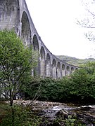 The Glenfinnan Viaduct from below.
 -

-
 Loch Scavaig, Isle of Skye
 -

-
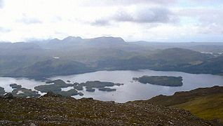 The islands of Loch Maree
 -
 The interior of Smoo Cave, Sutherland
 -
 Cape Wrath Lighthouse in the far NW of the Highlands
 -
 Blaven
 -

-
 The Kyle of Durness
 -
 The Quirang, Isle of Skye
 -
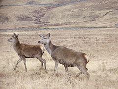 Two hinds in the Highlands
 -
 Loch an Lòin
 -
 Highland Cattleoriginates from the Scottish Highlands


See also
- Ben Nevis
- Buachaille Etive Mòr
- The Cheviot, the Stag and the Black, Black Oil by John McGrath
- Fauna of Scotland
- Highland 2007
- James Hunter (historian), historian who wrote several books related to the Scottish Highlands
- List of fauna of the Scottish Highlands
- List of towns and villages in the Scottish Highlands
- Mountains and hills of Scotland
Notes
References
- ^ "Highlands | region, Scotland, United Kingdom". Encyclopædia Britannica. Retrieved 10 May 2017.
- ^ ISBN 978-1-78027-165-1.
- ^ The Highland Council. Retrieved 2 June 2014.
- ^ "Taiga | Plants, Animals, Climate, Location, & Facts | Britannica". www.britannica.com. Retrieved 4 May 2023.
- ISBN 978-0-415-01035-1.
- ISBN 978-0-7486-0754-9.
- ^ "The Highland Line". Sue & Marilyn. Archived from the original on 8 August 2017. Retrieved 8 March 2013.
- ^ "Historical Geography of the Clans of Scotland". Electricscotland.com. Retrieved 8 March 2013.
- ISBN 0-7486-1034-0.
- ^ ISBN 978-0-7190-9076-9.
- ^ ISBN 978-0-241-30410-5.
- ISBN 978-1-902930-29-9.
- ^ ISBN 978-3-638-81651-9.
- ISBN 978-0-8387-5526-6.
- ISBN 978-0-7486-1071-6.
- ISBN 978-1-899820-79-5.
- ISBN 978-0-7099-2259-9.
- ^ ISBN 1-904607-42-X.
- ISBN 978-0-7126-9893-1.
- ISBN 978-0-670-88811-5.
- ^ James Hunter (1974). "The Emergence of the Crofting Community: The Religious Contribution 1798–1843". Scottish Studies. 18: 95–116.
- ^ Ian Bradley (December 1987). "'Having and Holding' – The Highland Land War of the 1880s". History Today. 37 (12): 23–28. Retrieved 8 March 2013.
- .
- ^ "Highland Distilleries – Whisky Tours, Tastings & Map". www.visitscotland.com.
- ^ a b c Osborn, Jacob (13 August 2019). "A Comprehensive Guide to Scotland's Whisky Regions". Man of Many.
- ^ "Whisky Distilleries in the Highlands". VisitScotland. Retrieved 25 August 2021.
- .
- ^ Gerard Seenan (10 April 2006). "Fury at ferry crossing on Sabbath". The Guardian. Retrieved 8 March 2013.
- ^ Cook, James (29 March 2011). "Battle looms in Outer Hebrides over Sabbath opening". BBC News. Retrieved 3 June 2014.
- ^ "Whisky Regions & Tours". Scotch Whisky Association. Archived from the original on 26 July 2018. Retrieved 8 March 2013.
- ^ "Inverness: Capital of the Scottish Highlands". Internet Guide to Scotland. Retrieved 8 March 2013.
- ^ "Scottish Highlands Landscape and History – Scotland Info Guide". www.scotlandinfo.eu.
- ^ C Michael Hogan (22 November 2007). "Elsick Mounth – Ancient Trackway in Scotland in Aberdeenshire". The Megalithic Portal. Retrieved 8 March 2013.
- ^ W. Douglas Simpson (10 December 1928). "The Early Castles of Mar" (PDF). Proceedings of the Society. Retrieved 8 March 2013.[dead link]
- ^ The Scottish Association of Citizens Advice Bureaux– Citizens Advice Scotland (Scottish charity SC016637). 25 January 2012. Retrieved 31 July 2013.
- ISBN 978-0-00-710353-9.
- ^ William Hutchison Murray (1973). The islands of Western Scotland: the Inner and Outer Hebrides. Eyre Methuen.
- ^ One or more of the preceding sentences incorporates text from a publication now in the public domain: Chisholm, Hugh, ed. (1911). "Highlands, The". Encyclopædia Britannica. Vol. 13 (11th ed.). Cambridge University Press. pp. 455–456.
Further reading
- Baxter, Colin, and C. J. Tabraham. The Scottish Highlands (2008), heavily illustrated
- Gray, Malcolm. The Highland Economy, 1750–1850 (Edinburgh, 1957)
- Humphreys, Rob, and Donald Reid. The Rough Guide to Scottish Highlands and Islands (3rd ed. 2004)
- Keay, J. and J. Keay. Collins Encyclopaedia of Scotland (1994)
- Kermack, William Ramsay. The Scottish Highlands: a short history, c. 300–1746 (1957)
- Lister, John Anthony. The Scottish Highlands (1978)
External links
- Am Baile – Highland History & Culture in English and Gaelic
- WalkHighland – walking guide
- National Library of Scotland: SCOTTISH SCREEN ARCHIVE (selection of archive films relating to the Scottish Highlands)