
Sehel Island

Sehel
Sehel Island (
Ancient Greek: Σῆτις)[1] is located in the Nile, about 2 miles (3.2 km) southwest of Aswan in southern Egypt. It is a large island, and is roughly halfway between the city and the upstream Aswan Low Dam.[2]
Geography
Sehel Island, spanning 3/4 the width of the Nile, is the primary large island below the Nile's
Kitchener's Island
. There are a dozen smaller islands scattered around them.
Archaeological artefacts
| |||||||
| sṯt[3] in hieroglyphs | |||||||
|---|---|---|---|---|---|---|---|
| Era: Old Kingdom (2686–2181 BC) | |||||||
| ||||
| sṯt(t)[3][4] in hieroglyphs | ||||
|---|---|---|---|---|
The island was known in ancient tiles as Setet,water goddess, and goddess of the Nile's cataracts.
Sehel was home to a
.Gallery
-
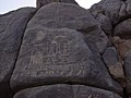 Sehel Inscriptions, in island's granite boulders.
 -
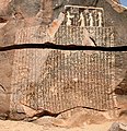 The Famine Stela, Sehel Island.

.jpg)
References
- ^ "TM Places". www.trismegistos.org. Retrieved 2020-06-22.
- ^
Aswan area map, Planetware.com, web JPEG image:
PW:
(map shows major islands near Aswan Dam and Aswan High Dam).
- ^ a b Gauthier, Henri (1928). Dictionnaire des Noms Géographiques Contenus dans les Textes Hiéroglyphiques Vol. 5. pp. 94–95.
- ^ Wallis Budge, E. A. (1920). An Egyptian hieroglyphic dictionary: with an index of English words, king list and geological list with indexes, list of hieroglyphic characters, coptic and semitic alphabets, etc. Vol II. John Murray. p. 1037.
- ^ "Switching..." www.thaliatook.com. Retrieved 2018-02-24.
External links
Wikimedia Commons has media related to Sehel Island.
Islands of Egypt | ||
|---|---|---|
| Nile islands |
| |
| Red Sea islands |
| |
| Mediterranean Sea islands | ||
| National | |
|---|---|
| Geographic | |
24°03′33″N 32°52′16″E / 24.05917°N 32.87111°E
This article about subjects relating to Ancient Egypt is a stub. You can help Wikipedia by expanding it. |
This geography of Egypt article is a stub. You can help Wikipedia by expanding it. |