
Sekondi-Takoradi
Sekondi-Takoradi
City of Sekondi-Takoradi | |
|---|---|
City | |
private housing estates . | |
|
UTC+0 (GMT) | |
| Postal codes | WS000-WS792 |
| Area code | 031 |
| Website | www |
Sekondi-Takoradi is a city in
History

Sekondi, an older town, was the site of Dutch
During
The cities combined in 1946. On 20 November 1969, the city became the seat of the Roman Catholic Diocese of Sekondi–Takoradi.
The city is currently named (although not officially) as the Oil City of Ghana due to the massive discovery of oil in the Western region and has attracted massive migration from people all around the world.[9] For example, of the 248,680 people in the Sekondi-Takoradi metro area in 2010, some 148,000, or well above half, were indigenous Ahanta people, 30,000 came from the central region of Ghana, 60,000 are from other regions of Ghana and 10,000 are foreign nationals.[10]
Demographics
Sekondi-Takoradi's population is overwhelmingly Christian. 35% of the region are Pentecostal/Charismatic, 26% are Protestant and 14% are Catholic with the remaining 12% comprising numerous minor denominations. 9% of the population are Muslim, 3.5% identify as non-religious and 0.2% practice
Culture and tourism
Sekondi has a rich cultural heritage, and the city is home to several landmarks and tourist attractions. The city's most notable landmark is the Sekondi European Town, which was built by the British during the colonial era. The town features several well-preserved colonial buildings, including the Governor's Residence, the Post Office, and the District Commissioner's Office.
Economy
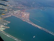
Sekondi is a bustling commercial center with a thriving economy. The city's location on the coast makes it an essential hub for fishing and trading activities. The Sekondi Fishing Harbour is the largest fishing port in Ghana and provides employment to thousands of people in the region. The city is also a center for the timber and cocoa industries, which are vital to the country's economy. Takoradi houses the Harbour and has timber, energy and technology industries. Over the years it has attracted a good number of investors, including miners, as the city is close to the mining towns in the western part of Ghana.[6] Ghana's recent discovery of oil gave the Sekondi-Takoradi township to be known as the Oil City.
Transportation
Sekondi is well-connected to other parts of Ghana and neighboring countries through a network of roads and railways. The city's port is a vital transportation hub, with several shipping lines providing regular services to other West African countries and Europe. The Takoradi Airport (TDI), located about 5 km from Sekondi, provides air transportation to other parts of Ghana and international destinations. There are public transport connections from Takoradi to major cities such as Accra; Kumasi; Mim; Cape Coast; Sunyani; Tamale; Tema; Ho; Wa; Bolgatanga; Elubo; Aflao; and Techiman.
Tourist attractions
Sekondi-Takoradi has plenty of beaches, however they are not a major tourist attraction. Many of the beaches are found to the west of Takoradi, with small resorts such as Fanta's Folly, The Hideout, Allan Beach and Vienna Beach. It also has an annual
Education
Sekondi-Takoradi city has several secondary schools, colleges, and special schools, ranging from single-sex to coeducational institutions. Among the tertiary institutions are: Takoradi Technical University (a public institution), Nurses and Midwifery Training College, Holy Child Teachers Training College (now a College of Education).[13] The Sekondi-Takoradi city currently has several secondary schools and Special schools, ranging from single-sex to coeducational institutions. These include:
- St. John's School (The Saints)
- Ghana Senior High Technical School(GSTS)
- Baidoo Bonsoe Senior High Technical School (BBSTS)
- Takoradi Secondary School (Tadisco)
- Methodist senior high school ( The Young legend)
- Sekondi College (Sekco)
- Ahantaman Senior High School
- Fijai Secondary School
- Adiembra Secondary School
- Bompeh senior high technical school
- Archbishop Porter Girls Secondary School and many others.[13]
Takoradi Technical Institute houses a fab lab, equipped by the Massachusetts Institute of Technology (MIT), which is the first of its kind in Africa.[13]
Takoradi has a well-equipped technical training center (
The Western Regional Library was established in Sekondi in 1955.[14]
Stadiums and sports

Stadiums
- Essipong Stadium
- Gyandu Park
Sports
Professional sports teams based in Sekondi-Takoradi include:
- FC Takoradi
- Sekondi Hasaacas
- Sekondi Wise Fighters
Institutions
- Empire FM[15]
Climate
Sekondi-Takoradi has a tropical savanna climate (Köppen climate classification: Aw).
| Climate data for Sekondi-Takoradi | |||||||||||||
|---|---|---|---|---|---|---|---|---|---|---|---|---|---|
| Month | Jan | Feb | Mar | Apr | May | Jun | Jul | Aug | Sep | Oct | Nov | Dec | Year |
| Record high °C (°F) | 35.0 (95.0) |
35.5 (95.9) |
35.0 (95.0) |
34.6 (94.3) |
34.6 (94.3) |
32.3 (90.1) |
31.8 (89.2) |
30.4 (86.7) |
31.2 (88.2) |
32.0 (89.6) |
34.5 (94.1) |
34.2 (93.6) |
35.5 (95.9) |
| Mean daily maximum °C (°F) | 30.4 (86.7) |
31.0 (87.8) |
31.3 (88.3) |
31.1 (88.0) |
30.2 (86.4) |
28.4 (83.1) |
27.3 (81.1) |
26.8 (80.2) |
27.6 (81.7) |
28.8 (83.8) |
30.0 (86.0) |
30.3 (86.5) |
29.4 (84.9) |
| Daily mean °C (°F) | 26.2 (79.2) |
26.9 (80.4) |
27.2 (81.0) |
27.2 (81.0) |
26.7 (80.1) |
25.6 (78.1) |
24.8 (76.6) |
24.1 (75.4) |
24.6 (76.3) |
25.5 (77.9) |
26.2 (79.2) |
26.2 (79.2) |
26.0 (78.8) |
| Mean daily minimum °C (°F) | 21.8 (71.2) |
22.6 (72.7) |
23.1 (73.6) |
23.2 (73.8) |
23.1 (73.6) |
22.8 (73.0) |
21.8 (71.2) |
21.1 (70.0) |
21.7 (71.1) |
22.1 (71.8) |
22.2 (72.0) |
22.1 (71.8) |
22.3 (72.1) |
| Record low °C (°F) | 16.1 (61.0) |
18.3 (64.9) |
20.6 (69.1) |
20.6 (69.1) |
20.0 (68.0) |
19.4 (66.9) |
17.2 (63.0) |
16.1 (61.0) |
17.8 (64.0) |
18.9 (66.0) |
18.9 (66.0) |
16.1 (61.0) |
16.1 (61.0) |
| Average rainfall mm (inches) | 31 (1.2) |
35 (1.4) |
79 (3.1) |
115 (4.5) |
250 (9.8) |
346 (13.6) |
120 (4.7) |
43 (1.7) |
57 (2.2) |
138 (5.4) |
77 (3.0) |
31 (1.2) |
1,322 (51.8) |
| Average rainy days (≥ 0.3 mm) | 3 | 4 | 7 | 10 | 17 | 19 | 13 | 11 | 13 | 14 | 10 | 5 | 126 |
| Average relative humidity (%)
|
86 | 85 | 83 | 84 | 84 | 86 | 87 | 87 | 87 | 87 | 86 | 85 | 86 |
| Mean monthly sunshine hours | 207.7 | 209.1 | 229.4 | 216.0 | 192.2 | 132.0 | 148.8 | 133.3 | 126.0 | 195.3 | 243.0 | 229.4 | 2,262.2 |
| Mean daily sunshine hours | 6.7 | 7.4 | 7.4 | 7.2 | 6.2 | 4.4 | 4.8 | 4.3 | 4.2 | 6.3 | 8.1 | 7.4 | 6.2 |
| Source: Deutscher Wetterdienst[16] | |||||||||||||
Sister cities
Gallery
-
 Virgin Island in Sekondi-Takoradi.
 -
 Beach on Virgin Island in Sekondi-Takoradi.
 -
-
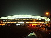 Sekondi-Takoradi Stadium at night.
 -
 Shores.
 -
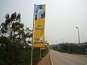 Highway in Sekondi-Takoradi.
 -
 Commuterson street in Sekondi-Takoradi.
 -
 Takoradi Airport (Sekondi-Takoradi Airport).
 -
 A house in Takoradi (Sekondi-Takoradi).
.jpg)
.jpg)


.jpg)

See also
- Takoradi Airport
- Takoradi Harbour
- Market Circle, Takoradi
- Railway stations in Ghana
References
- ^ a b "World Gazetteer online". World-gazetteer.com. Archived from the original on 30 September 2007. Retrieved 8 February 2014.
- ^ "Betway extends support to Volleyball Teams in the Western and Western North Regions". Citi Sports Online. 21 May 2021. Retrieved 21 May 2021.
- ^ "Twin-Cities project to plant 5,000 fruit-trees in Sekondi-Takoradi". Citinewsroom - Comprehensive News in Ghana. 4 February 2022. Retrieved 22 July 2023.
- ^ a b "Private Tutor". Infoplease.com. Retrieved 8 February 2014.
- ^ "Ministry of Railways Development - Ghana - railways development construction on western and eastern lines speeds off steadily". www.mrd.gov.gh. Retrieved 22 July 2023.
- ^ a b "Takoradi Port", Ghana Ports and Harbour Authority. Archived 31 December 2007 at the Wayback Machine
- ISBN 9780821414309. Retrieved 8 February 2014 – via BiblioVault.
- ^ "South Africa War Graves Project". Southafricawargraves.org. 8 October 2011. Retrieved 8 February 2014.
- ^ Obeng-Odoom F., 2014, Oiling the Urban Economy: Land, Labour, Capital, and the State in Sekondi-Takoradi, Ghana, Routledge, London.
- ^ Stats Ghana report on Sekondi-Takoradi population
- ^ Ghana Statistical Service report on Sekondi-Takoradi
- ^ "Sekondi-Takoradi Masqueraders Street Carnival". CNN iReport. Retrieved 2 September 2016.
- ^ a b c [1] Archived 25 March 2012 at the Wayback Machine
- ISBN 9783110230710
- ^ Starrfm.com.gh (15 July 2021). "Tarkwa: Awudua Gyaasehene reportedly kidnapped – Starr Fm". Retrieved 22 May 2022.
- ^ "Klimatafel von Takoradi (Sekondi-Takoradi) / Ghana" (PDF). Baseline climate means (1961-1990) from stations all over the world (in German). Deutscher Wetterdienst. Retrieved 18 October 2016.
Afrosages.com, Tourist Destinations Of Western Ghana, January 13, 2020
Wildcat Beauty, Cosmetics & More, Market Circle (behind Bank of Africa (Takoradi, Ghana [2]
External links
- Mytakoradi.com
- Ghana-pedia webpage – Takoradi
 Media related to Sekondi-Takoradi at Wikimedia Commons
| 2,000,000+ |   | |
|---|---|---|
| 1,000,000+ | ||
| 800,000+ | ||
| 100,000+ |
| |
| 80,000+ | ||
| 60,000+ |
| |
| 40,000+ | ||
| 20,000+ |
| |
| 5,000+ | ||
| ||
| International | |
|---|---|
| National | |
| Geographic | |