
Senj
Senj | |
|---|---|
| Grad Senj Town of Senj | |
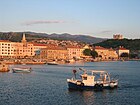
      Clockwise, from top: Senj harbour, City walls, example of renaissance housing architecture, Nehaj, Co-Cathedral of the Assumption of Mary, Senj, Bell tower of the Co-Cathedral | |
 Seal | |
 | |
 Senj Location of Senj within Croatia | |
| Coordinates: 44°59′24.52″N 14°54′10.96″E / 44.9901444°N 14.9030444°E | |
| Country | |
| County | |
| Government | |
| • Mayor | Jurica Tomljanović (HDZ) |
| • Town Council | 13 members |
| Area UTC+2 (CEST) | |
| Postal code | 53 270 |
| Area code | 053 |
| Website | senj |
Senj (Croatian:
The symbol of the town is the
Senj is to be found in the Lika-Senj County of Croatia, the Roman Catholic Diocese of Gospić-Senj and the Roman Catholic Archdiocese of Rijeka.
History

Senj has apparently been inhabited since prehistoric times. Senj is an old settlement founded more than 3000 years ago on Kuk
Senia was a thriving town in the Roman province of Dalmatia, used by the Romans as a stronghold against the Illyrians in the 2nd century BC. After the fall of the Roman Empire, the Avars and the Croats eventually settled here in the 7th century AD.
The Catholic
In 1248 the bishop of Senj was allowed by
The military captaincy of Senj was established in 1469 in order to defend against the invading Ottoman and Venetian armies. The town sheltered thousands of refugees from nearby occupied areas. The Nehaj Fortress was completed in 1558 on the hill Nehaj, which at the time was outside of town. Today it is wholly within the town's borders. The wars with the Ottomans lasted well into the 17th century. During this time the Uskoks lived in Senj and occupied the fortress. They served an important purpose during the wars since they had small units of men rowing swift boats that proved to be very effective guerrilla forces. However, after the Uskok War with Venice, which ended in 1617, they were forbidden to settle in the area. Prince Radic was appointed Prince of Senj by king Rudolf emperor of Austria (1 December 1600). (Radic family) Native noble family from Lika region; members of the family were Uskok military leaders at the headquarters in Senj.
The 18th century brought some prosperity, especially with the construction of the ) and Karlovac did not pass by Senj which held back further development.
Until 1918, the town was part of the
In the fall of 1943, during
Climate
Senj has a temperate climate which is usually described as temperate Oceanic or Marine west coast, with mild, windy winters and relatively dry and warm summers. According to the Köppen climate classification it falls within a cool, dry-summer subtropical zone (Csb), with cool-summer Mediterranean characteristics such as its usually dry summers.
| Climate data for Senj | |||||||||||||
|---|---|---|---|---|---|---|---|---|---|---|---|---|---|
| Month | Jan | Feb | Mar | Apr | May | Jun | Jul | Aug | Sep | Oct | Nov | Dec | Year |
| Record high °C (°F) | 20.3 (68.5) |
22.2 (72.0) |
25.9 (78.6) |
29.5 (85.1) |
33.6 (92.5) |
36.3 (97.3) |
39.7 (103.5) |
38.6 (101.5) |
35.6 (96.1) |
29.9 (85.8) |
26.9 (80.4) |
20.9 (69.6) |
39.7 (103.5) |
| Daily mean °C (°F) | 6.1 (43.0) |
6.6 (43.9) |
9.5 (49.1) |
13.3 (55.9) |
17.9 (64.2) |
21.9 (71.4) |
24.5 (76.1) |
24.2 (75.6) |
20.2 (68.4) |
15.6 (60.1) |
11.1 (52.0) |
7.5 (45.5) |
14.9 (58.8) |
| Record low °C (°F) | −11.8 (10.8) |
−16.6 (2.1) |
−9.3 (15.3) |
−0.8 (30.6) |
3.4 (38.1) |
7.6 (45.7) |
10.5 (50.9) |
8.2 (46.8) |
6.7 (44.1) |
1.6 (34.9) |
−4.9 (23.2) |
−10.4 (13.3) |
−16.6 (2.1) |
| Average precipitation mm (inches) | 94.2 (3.71) |
90.4 (3.56) |
86.7 (3.41) |
96.1 (3.78) |
91.7 (3.61) |
84.9 (3.34) |
64.5 (2.54) |
94.6 (3.72) |
137.9 (5.43) |
143.4 (5.65) |
165.3 (6.51) |
124.5 (4.90) |
1,274.2 (50.16) |
| Average rainy days | 10 | 9 | 10 | 12 | 11 | 10 | 8 | 8 | 9 | 10 | 13 | 12 | 122 |
| Average snowy days | 2 | 3 | 2 | 0 | 0 | 0 | 0 | 0 | 0 | 0 | 1 | 2 | 10 |
| Mean monthly sunshine hours | 100.9 | 123.2 | 158.1 | 187.7 | 242.7 | 265.8 | 310.2 | 287.2 | 214.7 | 167.6 | 101.8 | 90.2 | 2,250.1 |
| Source: Croatian Meteorological and Hydrological Service[8] | |||||||||||||
Economy

Modern Senj is a seaside tourist town. Primary industries are fishing, boating, and tourism.
Population
As of the 2021 census, Senj had a population of 5,973, with 97.30% being ethnic Croats. The largest minorities are Serbs with a population of 43 (0.72%) and Albanians with a population of 27 (0.45%)[9][10]
| population | 13268 | 15295 | 14782 | 14852 | 15857 | 16713 | 14963 | 14572 | 13289 | 12953 | 12235 | 10399 | 9582 | 9205 | 8132 | 7182 | 5973 |
| 1857 | 1869 | 1880 | 1890 | 1900 | 1910 | 1921 | 1931 | 1948 | 1953 | 1961 | 1971 | 1981 | 1991 | 2001 | 2011 | 2021 |
There are 27 settlements in the Town of Senj and they include (population as of 2011):[11]
- Alan, population 17
- Biljevine, population 51
- Bunica, population 85
- Crni Kal, population 72
- Jablanac, population 83
- Klada, population 39
- Krasno, population 476
- Krivi Put, population 33
- Lukovo, population 36
- Melnice, population 57
- Mrzli Dol, population 28
- Pijavica, population 262
- Podbilo, population 25
- Prizna, population 45
- Senj, population 4,810
- Senjska Draga, population 85
- Starigrad, population 15
- Stinica, population 73
- Stolac, population 41
- Sveta Jelena, population 16
- Sveti Juraj, population 599
- Velike Brisnice, no population
- Veljun Primorski, population 70
- Volarice, population 86
- Vrataruša, population 11
- Vratnik, population 59
- Vrzići, population 8
Notable people
- Blaž Baromić (c. 1450 – 1505)
- Nikola Jurišić (1490 – 1545)
- Ivo Senjanin (c. 1571 – 1612)
- Pavao Ritter Vitezović (1652 – 1713)
- Ivan Paskvić (1754 – 1829)
- Vjenceslav Novak (1859 – 1905)
- Silvije Strahimir Kranjčević (1865 – 1908)
- Milan Ogrizović (1877 – 1923)
- Eugen Kvaternik (1825 – 1871)
- Milan Moguš
- Vladimir Ćopić
- Sandra Šarić
- Edi Karić
- Domagoj Krajina
- Milan Ćopić
Twin towns – sister cities
Gallery
-
 Senj waterfront
 -
 Senj harbor chained with snow after a cold front
 -
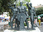 The Three Seamen statue
 -
 The Sundial in the town that lies on the north 45th parallel
 -
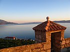 View of the Adriatic Sea
 -
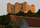 Thefortress Nehajis the most famous monument and symbol of Senj
 -
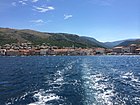 A view of Senj from the sea.


References
- Wikidata Q119585703.
- ^ "Population by Age and Sex, by Settlements, 2021 Census". Census of Population, Households and Dwellings in 2021. Zagreb: Croatian Bureau of Statistics. 2022.
- ^ Deanović, Mirko; Jernej, Josip (1975). "Sȅnj". Hrvatsko ili srpsko-talijanski rječnik (4th ed.). Zagreb: Školska knjiga.
- ^ a b "Povijest grada | Grad Senj – Službene stranice Grada Senja". www.senj.hr. Retrieved May 24, 2023.
- ^ Perhaps Regiment II. The map shows Zengg at the borderline between II and III.
- ^ Handbook of Austria and Lombardy-Venetia Cancellations on the Postage Stamp Issues 1850–1864, by Edwin MUELLER, 1961.
- ISSN 0582-673X.
- ^ "Mjesečne vrijednosti za Senj u razdoblju1948−2014" (in Croatian). Croatian Meteorological and Hydrological Service. Retrieved December 3, 2015.
- ^ https://podaci.dzs.hr/media/y00bavu1/popis_2021-stanovnistvo_najveci_gradovi_opcine_i_naselja.xlsx census spreadsheet
- ^ https://podaci.dzs.hr/media/td3jvrbu/popis_2021-stanovnistvo_po_gradovima_opcinama.xlsx census spreadsheet
- ^ "Population by Age and Sex, by Settlements, 2011 Census". Census of Population, Households and Dwellings 2011. Zagreb: Croatian Bureau of Statistics. December 2012.
- ^ "Gradovi prijatelji Grada Senja" (in Croatian). Senj. Retrieved February 8, 2024.
External links
Subdivisions of Lika-Senj County | ||
|---|---|---|
| Towns |  | |
| Municipalities | ||
| International | |
|---|---|
| National | |