
Seoul Metropolitan Subway
This article has multiple issues. Please help improve it or discuss these issues on the talk page. (Learn how and when to remove these template messages)
|
| Seoul Metropolitan Subway | |||
|---|---|---|---|
standard gauge | |||
| |||
| Seoul Metropolitan Subway | |
| Hangul | |
|---|---|
| Hanja | |
| Revised Romanization | Sudogwon Jeoncheol |
| McCune–Reischauer | Sudokwŏn Chŏnch'ŏl |
The Seoul Metropolitan Subway (
The network consists of multiple systems that form a larger, coherent system. These being the Seoul Metro proper, consisting of Seoul Metro lines 1 through 9 and certain light rail lines, that serves Seoul city proper and its surroundings; Korail regional rail lines, which serve the greater metropolitan region and beyond; Incheon Metro lines, operated by Incheon Transit Corporation, that serve Incheon city proper; and miscellaneous light rail lines, such as Gimpo Goldline and Yongin Everline, that connect lower-density areas of their respective cities to the rest of the network.[4] Most of the system is operated by three companies – Seoul Metro, Korail (Korea Railroad Corporation), and Incheon Metro - with the rest being operated by an assortment of local municipal corporations and private rail companies.
Its first metro line,
Overview
The first line of the Seoul Subway network started construction in 1971.
It has been described as the world's longest multi-operator metro system by
All directional signs in the system are written in Korean using Hangul, as well as English and Katakana/Chinese characters for Japanese and Mandarin Chinese. However the maps on the walls are in Korean and English only. In the trains, there are in addition many LCD screens giving service announcements, upcoming stop names, YTN news, stock prices and animated shorts. There are also prerecorded voice announcements that give the upcoming station, any possible line transfer, and the exiting side in Korean, followed by English. At major stations, this is followed by Japanese, then Mandarin Chinese, as well.[12]
Seoul Subway uses full-color LCD screens at all stations to display real-time subway arrival times,[13] which are also available on apps for smartphones.[14] Most trains have digital TV screens, and all of them have air conditioning and climate controlled seats installed that are automatically heated in the winter. In 2014, it became the world's first metro operator to use transparent displays for ads when it installed 48 transparent displays on major stations of Line 2 in Gangnam District.[13] All lines use the
Trains on numbered lines and light rail lines generally run on the right-hand track, while trains on the named heavy-rail lines (e.g. Shinbundang Line, Suin–Bundang Line, and AREX) run on the left-hand track. The exceptions are the trains on Line 1, as well as those on Line 4 south of Namtaeryeong station. These lines run on the left-hand track because these rail lines are government-owned via Korail or through-run to government-owned lines and follow a different standard to the metro, one that is followed by all national rail lines (with the exception of the otherwise self-contained Ilsan Line) because much of the Korean Peninsula's early rail network was constructed during Japanese rule.[15]
History
opened on 20 April 1985, andThe
Lines and branches
The system is organized such that numbered lines, with some exceptions, are considered as urban rapid transit lines located within the

| Line name | Terminus (Ascending / Descending) | Stations | Color | Total length | Opening Year | Last Extension | Operator | Owner | |
|---|---|---|---|---|---|---|---|---|---|
| Line 1 | Yeongdeungpo
|
Gwangmyeong / Seodongtan
|
102[Note 2] | Dark blue | 218.3 km[22][23][Note 3] | 1974 | 2023 | Korail / Seoul Metro | Government of South Korea / Seoul Metropolitan Government |
| Line 2 | Seongsu / Sindorim
|
Kkachisan
|
51 | Green | 60.2 km obsolete source ]
|
1980 | 1996 | Seoul Metro | Seoul Metropolitan Government |
| Line 3 | Daehwa | Ogeum | 44[Note 4] | Orange | 57.4 km[22][23][Note 5] | 1985 | 2010 | Korail / Seoul Metro | Government of South Korea / Seoul Metropolitan Government |
| Line 4 | Jinjeop | Oido | 51[Note 6] | Light blue | 72.1 km[22][23][Note 7] | 1985 | 2022 | Korail / Seoul Metro / Namyangju City Urban Corporation | |
| Line 5 | Banghwa | Hanam Geomdansan / Macheon | 56 | Purple/Violet | 63.0 km[23] | 1995 | 2021 | Seoul Metro | Seoul Metropolitan Government |
| Line 6 | Eungam | Sinnae
|
39 | Ocher[24] | 36.4 km[23] | 2000 | 2019 | ||
| Line 7 | Jangam | Seongnam | 53 | Olive Green[24] | 60.1 km[23] | 1996 | 2021 | Seoul Metro / Incheon Transit Corporation | Seoul Metropolitan Government / Bucheon City Council / Incheon Metropolitan City Council |
| Line 8 | Amsa | Moran | 18 | Pink | 17.7 km[23] | 1996 | 1999 | Seoul Metro | Seoul Metropolitan Government |
| Line 9 | Gaehwa / Gimpo International Airport[Note 8] | VHS Medical Center | 38 | Gold | 40.6 km | 2009 | 2018 | Seoul Metro Line 9 Corporation / Seoul Metro | |
| AREX | Seoul Station | Incheon Int'l Airport Terminal 2 | 14 | Sea-Blue[24] | 63.8 km | 2007 | 2018 | Airport Railroad Co., Ltd. | Government of South Korea |
| Gyeongui–Jungang Line | Munsan
|
Jipyeong / Seoul Station | 57 | Jade-Color[24] | 137.8 km[25] | 2005 | 2021 | Korail | |
| Gyeongchun Line | Chuncheon
|
24 | Teal[24] | 81.3 km[22] | 2010 | 2016 | |||
| Suin–Bundang Line | Wangsimni / Cheongnyangni[Note 10] | Incheon
|
63 | Orange-yellow | 104.6 km[26] | 1994 | 2020 | ||
| Ui LRT | Sinseol-dong | Bukhansan Ui | 15 | Light gold | 11.4 km[27] | 2017 | - | UiTrans LRT Co., Ltd. | Seoul Metropolitan Government |
| Sillim Line | Saetgang
|
Gwanaksan | 11 | Seoul-Skyblue[24] | 7.8 km | 2022 | - | South Seoul LRT Co., Ltd. | |
| Shinbundang Line | Sinsa | Gwanggyo | 16 | Red[24] | 33.4 km[28] | 2011 | 2022 | Shinbundang Railroad Corporation / Gyeonggi Railroad Co., Ltd. / New Seoul Railroad Co., Ltd. / Neo Trans | Government of South Korea |
| Incheon Line 1 | Gyeyang | Songdo Moonlight Festival Park | 30 | LightBlue[24] | 30.3 km | 1999 | 2020 | Incheon Transit Corporation | Incheon Metropolitan City Council |
| Incheon Line 2 | Geomdan Oryu | Unyeon | 27 | LightOrange[24] | 29.1 km | 2016 | - | ||
| EverLine
|
Giheung | Jeondae·Everland | 15 | Green[24] | 18.1 km[29] | 2013 | - | Yongin EverLine Co., Ltd. / Neo Trans | Yongin City Council |
| U Line | Balgok | Depot Temporary Platform | 16 | Mandarin[24] | 11.3 km[30] | 2012 | 2021 | Uijeongbu Light Rail Transit Co., Ltd | Uijeongbu City Council |
| Gyeonggang Line | Pangyo | Yeoju
|
11 | Korail-Blue[24] | 54.8 km | 2016 | - | Korail | Government of South Korea |
| Seohae Line | Ilsan | Wonsi
|
21 | Lime[24] | 47 km | 2018 | 2023 | Korail / SEO HAE RAIL CO.,LTD. (Subsidiary of Seoul Metro) / ERAIL Co., Ltd. | |
| Gimpo Goldline | Gimpo International Airport | Yangchon | 10 | Gold[24] | 23.7 km | 2019 | - | GIMPO Goldline Co., Ltd. (Subsidiary of Seoul Metro) | Gimpo City Council
|
Rolling stock
Fares and ticketing


The Seoul Metropolitan Subway system operates on a unified transportation fare system, meaning that subways and buses in Seoul, Incheon and Gyeonggi Province are treated as one system when it comes to fares. For example, a subway rider can transfer to any other line for free (with the exception of Shinbundang Line, EverLine and U Line, the latter two adding a flat charge of 200 and 300 won respectively). One can also transfer to any Seoul, Incheon, Gyeonggi-do, or some South Chungcheong Province city buses for free and get discounted fares on the more expensive express buses.[31]
In the case of Shinbundang Line, charges vary depending on the section used. The Sinsa - Gangnam section always charges 500 won, while the Gangnam - Jeongja section or the Jeongja - Gwanggyo section charges 1,000 won when used alone, and 1,400 altogether when used in conjunction with another. In total, the maximum added fee one can be charged is 1,900 won, which can be achieved by using all three sections.[32]
From 1974 until 1985, the subway's fare system was distance-based and Edmondson railway tickets, originally introduced for the Korean railways during Japanese rule, were used for fare validation. In 1985, the fare system changed to a zone-based system and magnetic-stripe paper tickets were introduced to replace the Edmondson system.
In 1996, the Seoul Metropolitan Subway became the first subway system in the world to roll out contactless smart cards, called Upass, for fare validation. These cards were issued up till October 2014, when they were discontinued in favour of the newer T-money cards.
Currently, the fare system is distance-based and accepted payment methods are single-use tickets, transportation cards including T-money and Cash Bee. Transportation cards can also be used on buses, taxis, convenience stores and many other popular retail places. Riders must tap in with a smartphone (KakaoPay and Samsung Pay/Wallet only), contactless-equipped credit or debit cards or other prepaid metro card at the entry gates. Popular methods of payments are using NFC-enabled Android smartphones (topped up or billed to the owner's credit/debit card via the T-money app) or credit or check (debit) cards with built-in RFID technology issued by the bank or card company.
The current single-use ticket is a credit card-sized plastic card with
Fares (except for single-use tickets) are currently 1,400 won for a trip up to 10 km (6.2 mi), with 100 won added for each subsequent 5 km (3.1 mi). Once 50 km (31.1 mi) has been passed, 100 won will be added every 8 km (5.0 mi).[33] Single-use ticket users must pay RFID deposit 500 won plus 100 won surcharge to fare.
Half-priced children's tickets are available. The city government also uses
International travelers can also use a Metropolitan Pass (MPASS) which provides up to 20 trips per day during the prepaid duration of 1 day to 7 days. Depending on where you purchase the card, the service is limited to the Seoul metropolitan area or Jeju Island and does not work in taxis or certain convenience stores.[34][35]
Current construction
Opening 2024
- Gyeongui-Jungang Line at Guri station.
- Unjeong station (by December). The first phase of GTX A Line will ultimately include 11 stations over 83.3 km (51.77 mi), after the section between Seoul station and Suseo station is connected by 2025, and GTX A’s part of Samseong stationis opened by 2028.
- The Wonsi station to Seohwaseongnamyang Stationby December 2024.
Opening 2025
- The Sinansan Line will open April 2025. The line will start at Yeouido station and split into two branches: one to Hanyang University ERICA Campus station, and one to Songsan station on the Seohae Line. The latter branch will partially share tracks with the Seohae Line and the Gyeonggang Line.
- The Incheon Subway Line 1 will be extended north in May 2025 by 6.8 km (4.226 mi), from Gyeyang station to Geomdan station, with 3 new stations. Geomdan station is later expected to become a transfer station with the Gimpo Goldline and the Incheon Subway Line 2, for which extensions are in planning.
- The Wirye Line, another light metro line in southeastern Seoul, will open in September 2025 between Macheon station on Line 5 and will have two branches: one will head to Bokjeong station on Line 8 and Suin-Bundang line, and one at Namwirye station, also a station on Line 8, with 12 stations planned in total. While technically part of the subway system, the Wirye Line will actually be a tramway line.
- Suseo station.
Opening 2026
- The Dongbuk Line, a light metro line in northeastern Seoul, is scheduled to open in July 2026 with 14 stations between Wangsimni station and Eunhaeng Sageori station.[36]
- Hagik station, between Songdo station and Inha University station on the Suin–Bundang Line, will open as an in-fill station once the redevelopment of the surrouneding area is completed. This area will feature cultural, commercial, and medical facilities along with new residential areas.[37]
- GTX ALine, to go along with urban development in the area.
Opening 2027 or later
- Bongeunsa Stationon Line 9.
- Line 9 will be extended 4 stations eastwards from VHS Medical Center station to Saemteo Park station, with a transfer with Godeok station on Line 5 by 2028.
- The Suin-Bundang Line.
- The Indeogwon Stationby December 2028. The Line will have 17 stops and a length of 38.1 km.
Approved for construction
The following lines have not started construction, but are considered to be approved after their plans and their financing have been finalized. Most of these lines are scheduled to start construction in the next couple of years.
- The Wirye–Sinsa Line, a light metro line in southeastern Seoul, will open between Sinsa station and Wirye with 11 stations planned.[40]
- Line 7 will also be further extended 3 stations northwards from Okjeong station in Yangju, currently under construction, to the city of Pocheon, with a terminus at Pocheon station.
- Line 9 will also be further extended to the East, with 6 new stations across the Han river and northwards from Saemteo Park station to Pungyang station.
- The Yongsan station, with 3 new stations over 5.3 km. Construction will begin upon the completion of the transfer of ownership of the Yongsan Garrisonto the Korean government.
- The Gwanggyo Jungang station to Homaesil station, with 5 new stations and 11 km of tracks. Construction will begin in 2023.
- The Seobu Line is a new light metro line, which will have a length of 18 km and go through 16 stations, starting at Gwanaksan station, which is also the last station of the Sillim Line, and then go North-West across the Han River and up to Saejeol station on Line 6. Construction will begin in 2023.
- GTX B, which will go from Songdo station to Maseok station, should begin in 2024.
Planned
Seoul City
The Seoul Metropolitan government published a ten-year plan for expansion of the subway with the following projects under consideration.[41][42]
- Gangbukhoengdan Line, a new line running in an arc north of Seoul between Cheongnyangni station and Mok-dong station with 19 stations planned. The line will provide transfers to Lines 1, 3, 4, 5, 6, 9, AREX, Gyeongui–Jungang, Gyeongchun, Bundang and Ui line.[43]
- Ui LRT will open a branch line from Solbat Park station to Banghak station on Line 1, the extension will open with 3 stations.[44]
- Sinnae station with 12 stations and connections to the Gyeongchun Line and Line 6.[45]
- light metro Sillim Line in the southwestern area of Seoul running between Nangok-dong and Boramae Park with 5 stations planned.[46]
- light metro in southwestern Seoul running between Sinwol-dong and Dangsan station on line 2, with 12 stations planned.[47]
- Line 4 will start running express services between Danggogae station and Namtaeryeong station.[41]
- Line 5 will start running shuttle services connecting Gubeundari station on the mainline and Dunchon-dong station on the Macheon Branch.[41]
- The Sillim Line will be connected to Seobu Line with a track between Seoul National University station (Line 2) and Gwanaksan(Seoul National Univ.).[41]
Incheon City
The Incheon Metropolitan government is working on the Second Incheon Metro Network Construction Plan that inherits the Incheon Metro Network Construction Plan published in 2016. It includes the construction of five new tram lines. The draft is expected to be released in October 2020.[48]
- Incheon Subway line 3 is planned to be a semi-circular subway line of Incheon. It will intersect Dowon station and to Incheon Line 1 at Dongmak station.
Partial network map

Gallery
-
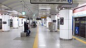 The platform at Hoehyeon Station on Seoul Subway Line 4 in Jung-gu, Seoul
 -
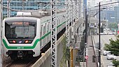 Seoul Metro Class 2000 series 10-car EMU set 2x13 leaving Hanyang University Station on the Seoul Metro Line 2 in Seongdong-gu, Seoul
 -
 A sign of Bongeunsa Station on Seoul Subway Line 9
 -
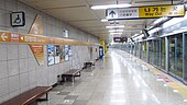 The platform at Hwarangdae Station on Seoul Subway Line 6 in Nowon-gu, Seoul
 -
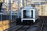 Seoul Metro Line 2 Inner Circle Line train arriving at Guro Digital Complex (2-14 new)
 -
 The no.3 entrance to Sinchon Station on the Seoul Metro Line 2 in Mapo-gu, Seoul
 -
 Seoul Metro Line 2 LCD


.jpg)


See also
Notes
- ^ With the exception of AREX on Yeongjong Island (extra charge applied depending on distance) and Shinbundang Line (extra charge of 500~1900 KRW depending on the sections used). EverLine and U Line will allow free transfers from 2014.
- ^ Of which 92 are operated by Korail and 10 by Seoul Metro.
- ^ Of which 210.5 km is operated by Korail and 7.8 km by Seoul Metro.
- ^ Of which 10 are operated by Korail and 34 by Seoul Metro.
- ^ Of which 19.2 km is operated by Korail and 38.2 km by Seoul Metro.
- ^ Of which 25 are operated by Korail and 26 by Seoul Metro.
- ^ Of which 40.4 km is operated by Korail and 31.7 km by Seoul Metro.
- ^ While Gaehwa is the official terminus, express trains only run to Gimpo International Airport station
- ^ Most trains run until Sangbong, very few trains operate to Kwangwoon Univ. and a few trains run to Cheongnyangni (However, express trains always go to Cheongnyangni)
- ^ Most trains run until Wangsimni and a few trains run to Cheongnyangni
References
- ^ "자료실 : 알림마당>자료실>자료실". www.seoulmetro.co.kr.
- ^ 수송현황 - 통계 - 량 [Transportation status - statistics - volume]. Korail (in Korean). Archived from the original on 14 November 2021.
- ^ 2012 Korail Statistics See p.400 for Seoul Metropolitan Subway (수도권 전철). Archived 27 February 2014 at the Wayback Machine
- ^ "Ministry of Land, Transport and Maritime Affairs of South Korea: Definition of Urban Rail and Wide-area Rail". Archived from the original on 25 April 2012.
- ^ "서울 지하철 1호선" (in Korean). Seoul Metropolitan Government. Retrieved 25 August 2015.
- ^ scaadmin (31 July 2015). "[Metro] Construction of the Seoul Metro – the Driver behind Sustainable Urban Growth & Change". 서울아카이브 Seoul Solution. Retrieved 27 July 2020.
- ^ "Seoul's first subway line opened in 1974". The Korea Times. 13 February 2011. Retrieved 25 July 2014.
- ^ "Introducing Korail". Korail. Retrieved 23 February 2014.
- ^ "The world's longest metro and subway systems". Railway-technology.com. 9 December 2013. Retrieved 7 September 2021.
- ^ "Underground world: Seoul's 'super highway' v London's 'rude tube'". BBC News. 3 April 2013. Retrieved 12 July 2013.
- ^ "대중교통 커뮤니티 - SBM (철도, 버스 이용자들의 공간) : 네이버 카페". cafe.naver.com. Retrieved 27 March 2018.
- ^ "Seoul Metropolitan Subway". Railway Technology. Retrieved 16 June 2022.
- ^ a b "낙후한 지하철 1~4호선, 첨단 디스플레이 기술로 새단장 나선다" [1-4 outdated subway line, state-of-the-art display technology sets out renovation]. etnews (in Korean). 15 March 2015. Retrieved 21 April 2015.
- ^ Malang Studio Co. Ltd. "Subway Korea - Android Apps on Google Play". google.com.
- ^ 문화일보 [Munhwailbo] (16 May 2006). "<오후여담>좌측통행" [<Afternoon digression> left side of the road]. Naver (in Korean). Naver Corp. Retrieved 21 April 2015.
- ^ "내년 지하철 9호선 마곡나루역 급행역사로 전환". 이데일리. 22 March 2017. Retrieved 27 March 2018.
- ^ "Seoul Gimpo Gold Line automated light metro opens". 30 September 2019.
- ^ "'추억의 꼬마열차' 수인선 수도권 남서지역 다시 누빈다". 서울일보 (in Korean). 13 September 2020. Retrieved 8 October 2022.
- ^ Burroughs, David (7 June 2022). "Seoul's Sillim Line rubber-tyred metro opens". International Railway Journal. Retrieved 8 October 2022.
- ^ https://english.visitseoul.net/transportation
- ^ https://koreajoongangdaily.joins.com/2022/05/29/national/socialAffairs/Korea-subway-Seoul/20220529174025996.html
- ^ a b c d "Metro Lines & Trains in Operation". Korail. Retrieved 25 July 2014.
- ^ a b c d e f g h 지하철건설현황 [Status of Subway Construction] (in Korean). Seoul City Government. Retrieved 22 February 2014.
- ^ a b c d e f g h i j k l m n "자료실 : 알림마당>자료실>자료실". www.seoulmetro.co.kr. Retrieved 16 January 2024.
- ^ "Southern portion of inter-Korean railway to reopen". The Hankyoreh. 25 December 2014. Retrieved 25 August 2015.
- ^ "Final Bundang Line Extension Opens". Kojects. 30 November 2013. Retrieved 26 August 2014.
- ^ "우이신설도시철도에 오신결 환영합니다". www.ui-line.com. Retrieved 27 March 2018.
- ^ "무인운전 시스템의 장점" (in Korean). Shinbundang Line & NeoTrans. Retrieved 25 July 2014.
- ^ "노선안내" (in Korean). Yongin Rapid Transit Corporation. Archived from the original on 10 August 2014. Retrieved 25 July 2014.
- ^ "사업개요" (in Korean). Uijeongbu LRT Corporation. Archived from the original on 2 November 2014. Retrieved 25 July 2014.
- ^ 신, 진호 (2 January 2022). "수도권 전철과 천안·아산 시내버스 '무료 환승'...알뜰교통카드 나왔다". JoongAng Ilbo (in Korean). Retrieved 10 October 2022.
- ^ "신분당선 운임안내" [Sinbundang Line Fare Information]. DX Line (in Korean). Retrieved 9 October 2022.
- ^ "User Guide > Fare". Seoul Metropolitan Subway. Retrieved 15 November 2023.
- ^ "Exclusive Tourist Cards". Korea Tourism Organization. 2 August 2018. Retrieved 26 November 2018.
- ^ "Tmoney Only for Foreigners: We would like to introduce Tmoney for Foreign Tourists". T-Money. Retrieved 26 November 2018.
- ^ "속도내는 동북선 경전철…2019년 착공". The Hankyoreh. 24 July 2017.
- ^ ""25분 거리를 10분만에… 지역경제도 살아났으면"… 27일 완전 재개통 앞둔 수인선 시범 운행". Kukmin Ilbo. 24 February 2016. Retrieved 27 March 2018.
- ^ "양주까지 7호선 연결 본격 시작…서울 접근성 기대".
- ^ "서울지하철 7호선 청라 연장사업 본궤도 진입…설계 착수". Yonhap News Agency. 4 May 2020.
- ^ "위례신사선 민자사업, 추진 확정..2021년께 착공 예상". NewsPim. 25 October 2018.
- ^ a b c d "[서울 도시철도망]강북횡단선 등 경전철 6개 노선 신설…서울 교통지도 바뀐다". 이투데이. 20 February 2019.
- ^ "News View :: The World on Arirang".
- ^ "2028년까지 목동~청량리 잇는 강북횡단선 등 경전철 6개 노선 신설". The Chosun Ilbo. 20 February 2019.
- ^ "우이신설역 연장 추진 확정, 솔밭공원~방학역 연결". 우먼컨슈머. 21 February 2019.
- ^ "[서울 도시철도망] 면목선, 동대문·중랑 상습정체 구간 해소". NewsPim. 20 February 2019.
- ^ "[서울 도시철도망] 난곡선, 남부순환로 이남 주거 밀집지 연결". NewsPim. 20 February 2019.
- ^ "[서울 도시철도망] 목동선, 서부서울 철도 사각지대 해소". NewsPim. 20 February 2019.
- ^ "인천시 철도과, 12월 국토부 '제2차 도시철도망구축계획' 승인 신청". 인천투데이. 16 September 2020.
External links
- Official websites by company
- Seoul city government
- The Seoul Underground Subway: Official Seoul Tourism
- English-language WMV video describing Seoul Subway history, current construction and future projects
| Railways |
| ||||||||||||||||
|---|---|---|---|---|---|---|---|---|---|---|---|---|---|---|---|---|---|
| Roads |
| ||||||||||||||||
| Buses |
| ||||||||||||||||
| Airports |
| ||||||||||||||||
| Related topics | |||||||||||||||||
| Seoul Capital Area |
| ||||||||||||||||
|---|---|---|---|---|---|---|---|---|---|---|---|---|---|---|---|---|---|
| Busan |
| ||||||||||||||||
| Daegu |
| ||||||||||||||||
| Gwangju | |||||||||||||||||
| Daejeon | |||||||||||||||||
Italics : Under construction | |||||||||||||||||
Rapid transit in Asia | |
|---|---|
| |
| |
* Under construction. | |