
Sepik
| Sepik | |
|---|---|
 Sediment plumes at the mouth of the Sepik (right) and Ramu (left) rivers | |
 Sepik River watershed (Interactive map) | |
| Location | |
| Country | Papua New Guinea, Indonesia |
| Region | Sandaun, Papua, East Sepik |
| Physical characteristics | |
| Source | |
| • location | Victor Emanuel Range, Papua New Guinea |
| • coordinates | 5°13′S 141°49′E / 5.217°S 141.817°E |
| • elevation | 2,170 m (7,120 ft) |
| Mouth | |
• location | Bismarck Sea, Papua New Guinea |
• coordinates | 3°50′30″S 144°32′30″E / 3.84167°S 144.54167°E |
• elevation | 0 m (0 ft) |
| Length | 1,146 km (712 mi) |
| Basin size | 80,321 km2 (31,012 sq mi)[1] |
| Depth | |
| • maximum | 35 m (115 ft) |
| Discharge | |
| • location | Bismarck Sea (near mouth) |
| • average | 7,000 m3/s (250,000 cu ft/s)[2] |
| • maximum | 26,000 m3/s (920,000 cu ft/s) |
| Discharge | |
| • location | Sepik-Ramu (Basin size: 100,243 km2 (38,704 sq mi) |
| • average | 7,663 m3/s (270,600 cu ft/s)[3]
8,000 m3/s (280,000 cu ft/s) 240 km3/a (7,600 m3/s) |
| • minimum | 4,363 m3/s (154,100 cu ft/s)[3] |
| • maximum | 10,963 m3/s (387,200 cu ft/s)[3] |
| Discharge | |
| • location | Ambunti (Basin size: 40,922 km2 (15,800 sq mi) |
| • average | 4,208 m3/s (148,600 cu ft/s)[5] (Period of data: 1967-1994)3,615 m3/s (127,700 cu ft/s)[4] |
| • minimum | 1,702 m3/s (60,100 cu ft/s)[4] |
| • maximum | 5,448 m3/s (192,400 cu ft/s)[4] |
| Basin features | |
| Tributaries | |
| • left | Yellow |
| • right | April, Karawari, Yuat, Keram |
The Sepik (
The Sepik has a large catchment area, and landforms that include swamplands,
Name
In 1884, Germany asserted control over the northeast quadrant of the island of
The word Sipik was first reported by A. Full[9] as one of two names for the watercourse—the other being Abschima—used by the natives living at the mouth of the river. A few years later, Leonhard Schultze applied the term Sepik to the entire watercourse, and it took, although Schultze also noted another name for the river, Azimar.[10] William Churchill, writing in the Bulletin of the American Geographical Society, wrote "These are not names of the river, they are but names for small stretches of the river as known to the folk of this or that hamlet. We cannot reckon how many such names there may be in the course of more than 600 miles of the system." Since "there is no indigenous name for the whole stream", Churchill concluded that "This is clearly a case where a European designation may properly be applied." He advocated for Kaiserin-Augusta. But that name faded with the German loss of colonial control over the territory after World War One. The word Sepik henceforth became the official name of the river.
Of course, each language group had one or more of its own names for the river. For example, the Iatmul people call the river Avusett, a compound of "bone" (ava) and "lake" (tset).[11]

Description
The river originates in the
For most of the Sepik's length, the river winds in serpentine fashion, like the Amazon River, to the Bismarck Sea off northern Papua New Guinea. Unlike many other large rivers, the Sepik has no delta whatsoever, but flows straight into the sea, about 100 kilometres (60 mi) east of the town of Wewak. It is navigable for most of its length. [citation needed]
The river has a total length of 1,126 kilometres (700 mi) and has a drainage basin of over 80,000 km2 (31,000 sq mi).[1] There is a 5-10 kilometre-wide belt of active meanders along most of its course, that has created a floodplain up to 70 kilometres wide, with extensive backwater swamps.[8] There are around 1,500 oxbow and other lakes in the floodplain, the largest of which are the Chambri Lakes.[8]
The Sepik basin is largely an undisturbed environment, with no major urban settlements, or mining and forestry activities, in the river catchment. [citation needed] April Salome Forest Management Area is located in Sepik River basin.
Peoples and languages
From the headwaters to the mouth, the river basin flows through the territories of spoken of dozens of Sepik languages,[13] each corresponding to one or more culture regions of related villages that exhibit similar social characteristics. The largest language and culture group along the river is the Iatmul people.
The Sepik-
History
Local villagers have lived along the river for many millennia and the river has formed the basis for food, transport and culture. There are at least 100 distinct villages and hamlets along the river, and most likely more.[16]

Early exploration
European contact with the river started in 1885, shortly after
In 1886 and 1887, further expeditions by
Europeans now increased their travels and presence along the river.[21] In the early twentieth century, several major expeditions to the river include the Südsee-Expedition sponsored by the Hamburg Academic of Science, the German-Dutch Border Expedition and the Kaiserin-Augusta-Fluss-Expedition[22] These expeditions, mainly German, collected flora and fauna, studied local tribes, and produced the first maps. The station town of Angoram was established in 1913 as a base on the lower Sepik for explorations, but with the beginning of World War I, the explorations ceased.[17]
After the first World War the Australian government took trusteeship of the German colony, creating the Territory of New Guinea, and the Sepik region came under their jurisdiction. During this period the Australians established a station on the middle Sepik at Ambunti to conduct further explorations.[17]
In 1923 journalist Beatrice Grimshaw attached herself to an expedition, and claimed to be the first white woman to ascent the Sepik, commenting on the widespread use of "pidgen-English" as a lingua franca.[23] In 1935 Sir Walter McNicoll, the new administrator of the Territory of New Guinea, travelled up length of the Sepik to "have a look at the river people and the kind of country along the banks".[24]
Modern 'explorers'
,_2012.jpg)
Despite the thorough exploration of the Sepik and the river basin by Europeans starting with the 1880s, and the extraordinarily keen knowledge of the region by local people and communities, many travelers today still see their tourism in the area as heroic efforts.
Part of this fantasy is that the river tribes are often said to have "little contact with the modern world," as the Los Angeles Times put it as late as 2017.[25] But that is just not true, and certainly not for a sizable tourist vessel operated by Coral Expeditions. Traveling the river is said to be "one of the last great adventures on earth".[26]
For example, in 2010 Clark Carter and Andrew Johnson traveled the length of the Sepik River from source to sea. They hiked to the source from Telefomin and kayaked down the upper reaches in an inflatable kayak. After nearly drowning in a section of rapids near Telefomin, they decided to walk through the jungle, following the river until it was calm enough to take a dugout canoe the remaining 900 kilometres to the Bismarck Sea. The expedition took six weeks. "The Sepik really appealed to me," said Carter, "because it conjures up images of remote tribes and wild animals. Probably the most alluring thing for me though, is just how un-travelled the area is."[27]
Also in 2010, the painter
World War II
The
The Australians eventually pushed the Japanese back to the village of
Sepik art

The Sepik is one of the most profuse and diverse art producing regions of the world. The numerous different tribes living along the river produce magnificent wood carvings, clay pottery and other art and craft. Different areas along the Sepik produce distinct art styles so an experience curator will be visually able to distinguish individual styles. The Sepik area is well known for its sculpture[33] masks[34] shields[35] and other artifacts. Many tribes use garamut drums in rituals; the drums are formed from long, hollowed-out tree trunks carved into the shape of various totem animals.[36][37][38]
Image gallery
-
 Korogo Village, Sepik River, PNG, 1975. Franz Luthi
 -
 A black-capped lory perching on a boy's head at Kaminabit village, Middle Sepik
 -
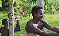 A warm welcome to foreign visitors
 -
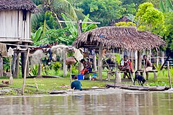 Snapshot of the daily life of the villagers


See also
References
- ^ a b "OC05 Sepik". Water Resources eAtlas. Watersheds of the World. Archived from the original on 2007-12-14.
- ^ "Dissolved Chemical Transport in Rivers of Papua New Guinea".
- ^ a b c Anders, Faaborg Povisen (1993). "Papua New Guinea-Fisheries survey of the upper Purari River Part 2-Results and discussion. A report prepared for the Sepik River Fish Stock Enhancement Project".
- ^ a b c "Papua New Guinea-PNG 3: Sepik Wara".
- ^ "TABLE DR1-River Data-Leier et. al-Megafan and non-megafan rivers". 2001.
- ^ "Sepik". Oxford English Dictionary (Online ed.). Oxford University Press. (Subscription or participating institution membership required.)
- ^ Fragmentation and Flow Regulation of the World’s Large River Systems
- ^ a b c "Sepik River". Rainbow Habitat. Archived from the original on 2007-05-31.
- ^ Full, A. 1909. "Eine Fahrt auf dem Kaiserin Augustafluß". Deutsches Kolonialblatt: Amtsblatt für die Schutzgebiete in Afrika und in der Südsee 20 (15) 739-41; 744–745.
- ^ Schultz, Leonhard. 1914. Forschungen im Innern der Insel Neuginea: Bericht des Führers über die wissenschaftlichen Ergebnisse der deutschen Grenzexpedition in das westliche Kaiser-Wilhelmsland 1910. Berlin: E. S. Mittler.
- ^ Silverman, Eric K. 2018. "The Sepik River, Papua New Guinea: Nourishing Tradition and Modern Catastrophe", in John R. Wagner and Jerry K. Jacka, eds., Island Rivers: Fresh Water and Place in Oceania, pp. 187–221, Canberra: ANU Press.
- hdl:2246/2593.
- ^ Laycock, Donald C. (1965). The Ndu language family (Sepik District, New Guinea). Canberra: Australian National University. OCLC 810186.
- ISBN 978-3-11-028642-7.
- ISBN 978-3-11-028642-7.
- ^ Still the best, most detailed map the river and region is Wewak: The Gateway to the Sepik: Maps of Wewak, West and East Sepik Provinces, published by Wirui Press, Wewak, Papua New Guinea, in the 1980s.
- ^ ISBN 0-86442-402-7.
- ^ See, e.g., Buschmann, Rainer F. 2009. Anthropology's Global Histories: The Ethnographic Frontier in German New Guinea, 1870-1935. Honolulu: University of Hawaii Press.
- ^ For a diary of the voyage, see Claas, Ulrike and Paul Rosco. 2009. Manuscript XXI: A Journey Up The Sepik River in 1887. The Journal of Pacific History 44 (3) 333-43.
- ^ Huber, Mary Taylor. 1988. The Bishops’ Progress: A Historical Ethnography of Catholic Missionary Experience on the Sepik Frontier. Washington, DC: Smithsonian Institution Press.
- ^ Bragge, Lawrence, Ulrike Claas, and Paul Roscoe. 2006. On the edge of empire: Military brokers in the Sepik “tribal zone.” American Anthropologist 33 (1) 100-113.
- ^ See Reche 1913, Schultz 1914, Behrmann 1922, Schindlbeck 1997.
- ^ Hoehn, Matthew, ed., 1948, Catholic Authors Contemporary Biographical Sketches, 1930-1947: Newark, NJ, St. Marys Abbey, p. 293-295, cited on "Grimshaw Origin" [1] accessed 6 August 2016
- ISBN 0-7015-0327-0.
- ^ McClure, Rosemary (2017-09-06). "Papua New Guinea river cruise takes you to see remote villages and ancient rain forests". Los Angeles Times. Retrieved 2023-06-14.
- ^ "Departures | 200 Miles Along the Sepik River". Departures. Retrieved 2023-06-14.
- ^ "Interview/debrief: Papua New Guinea Sepik River, hard as it comes," 15 January 2011, https://explorersweb.com/oceans/news.php?id=19891
- ^ Kühl, Ingo (2011). "Papua New Guinea". I. Kühl – via Deutsche Nationalbibliothek.
- OCLC 570739529.
- ISBN 978-1-107-08346-2.
- ^ "Aitape–Wewak Campaign". Australian War Memorial. Archived from the original on 13 March 2012. Retrieved 30 July 2010.
- ^ "Chapter Seven: Voices from Asia and the Pacific". War Compensation Forum. Archived from the original on 2011-09-28.
- ^ "Sepik Sculpture | Sepik river Sculpture | sell Sepik Sculpture". new guinea tribal arts. 2018-04-11. Retrieved 2018-11-13.
- ^ "Sepik masks | Sepik River masks | sell sepik mask | sell sepik river mask". new guinea tribal arts. 2018-03-02. Retrieved 2018-11-13.
- ^ "Sepik shields | Sepik River Shields | sell Sepik shield | wooden war shield". new guinea tribal arts. 2018-03-07. Retrieved 2018-11-13.
- ISBN 0792274172.
- ^ Salak, Kira. "Nonfiction book about Papua New Guinea,"Four Corners"".
- ^ Salak, Kira. "Includes photos of Art of Sepik River, Papua New Guinea".
External links
- Ibbitt, Richard; Takara, Kaoru; Mohd. Nor bin Mohd, Desa; Pawitan, Hidayat (2002). "Papua New Guinea: Sepik Wara" (PDF). Catalogue of rivers for Southeast Asia and the Pacific, vol. IV. UNESCO-IHP Regional Steering Committee for Southeast Asia and the Pacific. pp. 243–253. ISBN 4-9900653-1-X.
- The Sepik–Ramu System
- Sepik River
- Guide to Sepik River Carvings (Art-Pacific.com: New Guinea tribal art and Indonesian folk art)
- [2]
- A Report on the Sepik River Basin
- Papua New Guinea Sepik River Video
- The Sepik River Expedition 2010