
Serras de Aire e Candeeiros Natural Park
| Serras de Aire e Candeeiros Natural Park | |
|---|---|
ICNF | |
| Website | Serras de Aire e Candeeiros Natural Park |
Serras de Aire e Candeeiros Natural Park (PNSAC) is a natural park in central west Portugal. It occupies an area of 383.9 km2 (148.2 sq mi) and is the most important repository of limestone formations in Portugal with a variety of geological formations associated with karst topography such as caves (including pit caves), sinkholes, uvalas, poljes, limestone pavements, ponors, among others.[3] It was made a protected area in 1979 with the intend to protect the existing natural aspects and the architectonic and cultural heritage linked to the local populations.[4]
Location
The park is located in the
PNSAC is mainly composed by mountain ranges (Serras) and plateaus: The Serra de Aire (679 m (2,228 ft)) in the northeast; the Serra de Candeeiros (615 m (2,018 ft)) in the west, adjacent to Aire, between Porto de Mós and Rio Maior; the Santo António plateau in the centre and part of the São Mamede plateau in the north.[7][8]
Geomorphology
Orogeny

The park is located in the Estremadura Limestone Massif, a geomorphological unit of Portugal where rocks from the Jurassic flourish to a great extent.[9] The massif was created by the distensive opening phases of the Lusitanian Basin during the Mesozoic and the alpine compressive regimes established from the end of the Cretaceous.[10] The São Mamede Plateau and Serra de Aire are the result of a rollover anticline.
Geology
With a vigorous and rugged landscape, the park has some of the most interesting geological formations in the country.[11]
The nature park is evidenced both by its relief, as a prominent mass that rises about 200 m (660 ft) relative to its surroundings, and by its white, highly permeable
Similarly to river dynamics, water is collected in low areas or in depressions (such as
The terrain is characteristically dry due to its porosity and the first settlements were dependent on terra rossa for their activities. Currently, with the population less dependent on agricultural and pastoral activities, there has been a dispersion of buildings in the landscape, both for housing and for support of other economic activities. This diversification of the economy is partly responsible for the abandonment of the most traditional activities.[3]
Ecology
Flora
The natural park is part of the Southwest Iberian Mediterranean sclerophyllous and mixed forests and hosts more than 600 different plant species.[12] The vegetation that characterizes the PNSAC is the result of the bioclimatic influences on the territory. There is a great wealth of species with a diversity of sizes and origin (from Atlantic Europe, the Mediterranean, the Iberian Peninsula and North Africa), rare and unique Portuguese species, paleoclimatic species, some even used for medicinal, culinary, aromatic or ornamental purposes.[8] Though floristically rich, the park has suffered dramatic changes over the years. The Alvados Depression is a clear example of this dynamism; at present its landscape is agrarian; however, centuries ago, at the time of its occupation by its first settlers, the area was a marsh that was surrounded by oak groves, pine groves and strawberry trees. Later, with the romanization, it became an olive grove with grafts of wild-olive.[8]
The park has five main associated landscapes:[8][13]
- The
- The humid oak and pine forests, featuring Pinus pinea, Hedera hibernica, Viburnum tinus, Ruscus aculeatus, Pteridium aquilinum, one of the most representative vegetative formations in the park. Q. pyrenaicais restricted to the centre of the park and Q. suber is uncommon due to its dislike for calcareous soils
.jpg)
- The
- The human-introduced
- The riparian forests of Ulmus minor, Sambucus nigra, Salix atrocinerea, Salix alba, Alnus glutinosa, Tamarix gallica, Fraxinus angustifolia, very rare and degraded
Additionally, the park has 27 different species of
Fauna
The distribution and biodiversity of mammals is in part due to bioclimatic and geoecological characteristics. The fauna was drastically affected by the human occupation of this territory, which devastated habitats and destroyed resources.
- The micromammals, present by the orders insectivores, chiropterans, and rodents include the European hedgehog, the greater white-toothed shrew, the Etruscan shrew, the Iberian shrew, and the Spanish mole, the house mouse, the Algerian mouse, the black rat, the wood mouse, the Lusitanian pine vole, the Mediterranean pine vole, the greater horseshoe bat, the Mehely's horseshoe bat, the lesser horseshoe bat, the Mediterranean horseshoe bat, the Geoffroy's bat, the Bechstein's bat, the greater mouse-eared bat, the Natterer's bat, the lesser mouse-eared bat, the common pipistrelle, the serotine bat, the common bent-wing bat, or the European free-tailed bat
- The mesomammals are present by species of the order lagomorpha, which include the European rabbit and the Granada hare
- the large mammals group the carnivore and ungulate orders and are represented by the European badger, the beech marten, the Eurasian otter, the least weasel, the European polecat, the red fox, the common genet, the Egyptian mongoose, the Iberian lynx, the European wildcat and the domestic donkey
Among the several migratory and resident bird species the most common are the short-toed snake eagle, the common buzzard, the common cuckoo, the Eurasian hoopoe, the great spotted woodpecker, the crested lark, the woodlark, the Eurasian skylark, the red-rumped swallow, the white wagtail, the Eurasian wren, the European robin, the black redstart, the European stonechat, the blue rock thrush, the Sardinian warbler, the Eurasian blackcap, the Iberian chiffchaff, the short-toed treecreeper, the Red-billed chough, the carrion crow, the spotless starling, the common linnet, the cirl bunting or the corn bunting.[16]
Although lacking any water courses, the park has a surprising amount of
Unlike water courses, underground galleries are vast and a number os
The park has around 17 species of reptiles, which include the
Fish recorded in the park include the Iberian nase and Achondrostoma oligolepis.[14]
Climate

The park has a
The prevailing N-NW winds carry air masses loaded with moisture that cause intense fog and strong winter rainfall.
| Climate data for Serra de Santo António, altitude: 353 m (1,158 ft), 1984-2002 | |||||||||||||
|---|---|---|---|---|---|---|---|---|---|---|---|---|---|
| Month | Jan | Feb | Mar | Apr | May | Jun | Jul | Aug | Sep | Oct | Nov | Dec | Year |
| Average precipitation mm (inches) | 199.9 (7.87) |
134.8 (5.31) |
84.3 (3.32) |
112.2 (4.42) |
94.0 (3.70) |
32.9 (1.30) |
8.3 (0.33) |
8.2 (0.32) |
57.3 (2.26) |
148.0 (5.83) |
164.3 (6.47) |
191.9 (7.56) |
1,236.1 (48.69) |
| Source: Agência Portuguesa do Ambiente[20][21] | |||||||||||||
Natural heritage
Karst landscapes

There are over 130 identified caves in the park.[11] Some notable cave complexes include the Mira de Aire Caves, the Alvados Caves, the Almonda spring caves (including the Cave of Aroeira) and the Algar do Pena.[22]
Other notable geological formations include:
- Ramsar wetland[23] located between the towns of Minde and Mira de Aire, which floods with some frequency during the winter.[24]
- Alviela karst spring and the Ribeira dos Amiais ponor
- Fórnea, a natural amphitheatre formed by temporary springs[25]
- Arrimal Lagoons, sinkholes with naturally waterproofed bottoms with clays and other sediments[26]
Paleontology and archaeology
The park contains two
-
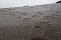
 Theropodfootprint in Vale de Meios
 -

-

-
 Sauropod footprints of the Serra de Aire Natural Monument
 -
 Christianized dolmen of Alcobertas
 -
 Roman road of Alqueidão da Serra


Threats

Even though a protected nature area was created to protect the existing natural aspects and architectonic heritage, the construction of
Views of the park from urban centers
-
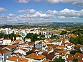
 East side of Serra de Aire as seen from the castle of Torres Novas
 -
 West side of Serra de Aire as seen from Fátima
 -
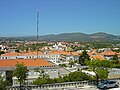 Southeast view of Serra de Santo António from Alcanena
 -
 West side view of Serra de Candeeiros from Alcobaça

.jpg)
.jpg)
.jpg)
References
- ^ "Serras de Aire e Candeeiros Nature Park". natural.pt. Retrieved 30 May 2021.
- ICNF. Retrieved 30 May 2021.
- ^ ICNF. p. 92. Retrieved 15 December 2020.
- ^ "Decreto-Lei 118/79, 1979-05-04" (in Portuguese). Diário da República. Retrieved 30 May 2021.
- ^ "Enquadramento Geológico e Geomorfológico". grutasdemiradeaire.com. Retrieved 15 December 2020.
- ^ "Parque Natural das Serras de Aires e Candeeiros". turismodocentro.pt. Retrieved 10 February 2021.
- ^ a b c d e f g h "Avaliação dos Impactes Ambientais dos Parques Eólicos em Áreas Protegidas: O Caso de Estudo do Parque Natural das Serras de Aire e Candeeiros" (PDF). Catarina Isabel Augusto Coelho. Retrieved 15 December 2020.
- ^ ISSN 1139-1987. Retrieved 30 May 2021.
- ^ M. F. Carvalho, Jorge; M. Prazeres, Cátia; Lisboa, José Vitor; J. Sardinha, Rui. "Rochas ornamentais do Maciço Calcário Estremenho: breve caraterização dos recursos, dos centros de produção e delimitação preliminar de áreas potenciais". Retrieved 29 May 2021.
- ^ "Geological heritage assessment in mining areas of serra de aire and candeeiros natural park". Jorge Manuel Ferreira Carvalho. Retrieved 15 December 2020.
- ^ a b c d "Parque Natural das Serras de Aire e Candeeiros". Infopédia - Dicionários Porto Editora (in Portuguese). Infopédia - Porto Editora Dictionaries. Retrieved 29 May 2021.
- ^ "Serra de Aire e Candeeiros". Minde Parish Council. Retrieved 15 December 2020.
- ^ a b "área protegida: serras de aire e candeeiros". Flora-On. Retrieved 15 December 2020.
- ^ a b "Serras de Aire e Candeeiros". Retrieved 30 May 2021.
- ^ a b "Parque Natural das Serras de Aire e Candeeiros". Turismo Médio Tejo. Retrieved 15 December 2020.
- ^ "Serra de Aire". www.avesdeportugal.info. Retrieved 30 May 2021.
- ^ a b Sofia Pereira Serrenho Reboleira, Ana. "Coleópteros (Insecta, Coleoptera) cavernícolas do Maciço Calcário Estremenho: uma abordagem à sua biodiversidade" (PDF). University of Aveiro. Retrieved 30 May 2021.
- ^ a b Paulo Jorge Silva Ferreira. "O património edificado molinológico no concelho de Porto de Mós: Reflexão para a sua preservação e reutilização na Serra de Candeeiros" (PDF). Universidade Lusófona. Retrieved 16 December 2020.
- ^ Solaris. Retrieved 15 December 2020.
- ^ "Serra de Santo António (16E/04U)". SNIRH. Retrieved 26 November 2021.
- ^ "Estudo de Impacte Ambiental da "Pedreira Vale do Mar"" (PDF). APA. Retrieved 12 December 2020.
- ^ "Algar do Pena". natural.pt. Retrieved 29 May 2021.
- ^ "Mira Minde Polje and related Springs | Ramsar Sites Information Service". rsis.ramsar.org. Retrieved 21 May 2021.
- ^ "Inventory of Sites with Geological Interest: Polje de Minde". geoportal.lneg.pt. Retrieved 29 May 2021.
- ^ "Fórnea (Chão das Pias)". www.municipio-portodemos.pt (in European Portuguese). Retrieved 29 May 2021.
- ^ "Lagoas do Arrimal". natural.pt. Retrieved 29 May 2021.
- ^ "Salinas de Rio Maior". Salgema (in European Portuguese). Retrieved 29 May 2021.
- ^ "Pegadas de Dinossauros de Vale dos Meios – Alcanede". serrasdeaireecandeeiros.com. Retrieved 15 December 2020.
- S2CID 54034942. Retrieved 15 December 2020.)
{{cite journal}}: CS1 maint: multiple names: authors list (link - ^ "Biostromas de corais e algas de Vale Florido". natural.pt. Retrieved 29 May 2021.
- ^ "Corte Geológico do Barranco de Zambujal". natural.pt. Retrieved 29 May 2021.
- ^ "Praia Jurássica de São Bento". serrasdeaireecandeeiros.com. Retrieved 15 December 2020.
- ^ Dário Estraviz-López, Octávio Mateus. "Tracks and multiple skeletons of brown bear (ursus arctos) in Algar do Vale da Pena, Portugal" (PDF). NOVA University Lisbon. Retrieved 15 December 2020.
- ^ "Dólmen e Igreja Paroquial de Santa Maria Madalena". www.turismoriomaior.pt. Retrieved 30 May 2021.
- ^ "Estrada Romana - Alqueidão da Serra". municipio-portodemos.pt. Retrieved 30 January 2021.
- ^ "Quercus faz balanço da intervenção no Parque Natural da Serra de Aire e Candeeiros, que cumpriu recentemente 35 anos". Quercus (organization). Retrieved 15 December 2020.