
Northeast India
This article currently links to a large number of disambiguation pages (or back to itself). (April 2024) |
Northeast India | ||
|---|---|---|
| North Eastern Region (NER) | ||
 | ||
 | ||
| Coordinates: 26°N 91°E / 26°N 91°E | ||
| Country | ||
| States | ||
| Largest city | 2011 Census of India)[1] | |
| Area | ||
| • Total | 262,184 km2 (101,230 sq mi) | |
| Population ( Scheduled languages | ||
| State/Regional official languages | ||
Northeast India, officially known as the North Eastern Region (NER), is the easternmost region of India representing both a geographic and political administrative division of the country.[18] It comprises eight states—Arunachal Pradesh, Assam, Manipur, Meghalaya, Mizoram, Nagaland and Tripura (commonly known as the "Seven Sisters"), and the "brother" state of Sikkim.[19]
The region shares an international border of 5,182 kilometres (3,220 mi) (about 99 per cent of its total geographical boundary) with several neighbouring countries – 1,395 kilometres (867 mi) with
The states of North Eastern Region are officially recognised under the
History

The earliest settlers may have been
In the early historical period (most of the first millennium CE), Kamarupa straddled most of present-day Northeast India. Xuanzang, a travelling Chinese Buddhist monk, visited Kamarupa in the 7th century CE. He described the people as "short in stature and black-looking", whose speech differed a little from mid-India and who were of simple but violent disposition. He wrote that the people in Kamarupa knew of Sichuan, which lay to the kingdom's east beyond a treacherous mountain.[29]
The northeastern states were established during the British Raj of the 19th and early 20th centuries, when they became relatively isolated from traditional trading partners such as Bhutan and Myanmar.[30] Many of the peoples in present-day Mizoram, Meghalaya and Nagaland converted to Christianity under the influence of British (Welsh) missionaries.[31]
Formation of North Eastern states
Since the
After
The city of Shillong served as the capital of the Assam province created during British Rule. It remained the capital of undivided Assam until the formation of the state of Meghalaya in 1972.[35] The capital of Assam was shifted to Dispur, a part of Guwahati, and Shillong was designated as the capital of Meghalaya.[citation needed]
| State | Historic Name | Capital(s) | Statehood |
|---|---|---|---|
| Arunachal Pradesh | North-East Frontier Agency | Itanagar | 1987 (earlier a Union Territory of India, constituted in 1971)[36] |
| Assam | Kamarupa | Shillong (till 1969), Dispur |
1947 |
| Manipur | Kangleipak[37] | Imphal | 1971 (earlier a Union Territory of India, constituted in 1956)[36] |
| Meghalaya | Khasi hills, Jaintia hills and Garo hills | Shillong | 1971[36] |
| Tripura | Tipperah[38] | Agartala | 1971 (earlier a Union Territory of India, constituted in 1956)[36] |
| Mizoram | Lushai Hills | Aizawl | 1987 (earlier a Union Territory of India, constituted in 1971)[36][39] |
| Nagaland | Naga Hills District | Kohima | 1963 |
| Sikkim | Sukhim | Gangtok | 1975 |
World War II
Initially, the Japanese had invaded British territories in Southeast Asia, including Burma (now Myanmar), with the intention of creating a fortified perimeter around Japan. The British had neglected the defense of Burma, and by early 1942, the Japanese had captured Rangoon and pushed Allied forces back towards India through a grueling retreat.[40]
In response to the Japanese advance, the British formed the South East Asia Command (SEAC) under Admiral Lord Louis Mountbatten in November 1943. This command brought new energy to the war effort in the region and emphasized the importance of standing firm and fighting on despite logistical challenges, such as during the monsoon season.[41]
The Japanese launched an offensive in March 1944 aimed at capturing Imphal and Kohima, key locations in northeast India. Capturing these areas would have allowed the Japanese to disrupt Allied supply lines to China and launch air attacks against India.[42]
However, the Allied forces, under the leadership of Field Marshal William Slim, held firm. They adopted aggressive tactics, including the creation of defensive "boxes" and the use of jungle warfare techniques. Despite being surrounded, the defenders at Kohima held out against intense Japanese attacks until reinforcements arrived.[43]
The battles of Imphal and Kohima resulted in a decisive defeat for the Japanese. They suffered heavy casualties and were forced to retreat, marking a turning point in the Burma Campaign. The Allied victory paved the way for subsequent offensives to clear Japanese forces from Burma and ultimately led to the re-conquest of the region.[44]
Sino-Indian War (1962)
Arunachal Pradesh, a state in the Northeastern tip of India, is claimed by China as
Seven Sister States
The Seven Sister States is a popular term for the contiguous
Geography
The Northeast region can be
The region is covered by the mighty Brahmaputra-Barak river systems and their tributaries. Geographically, apart from the
-
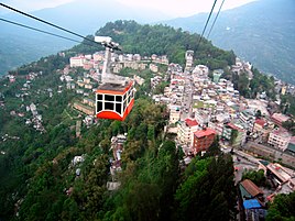 Ropeway, Gangtok
 -
-
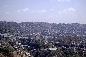
 Aerial view of Shillong
 -
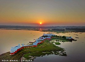 Neer Mahal of Tripura
 -

-

-

-
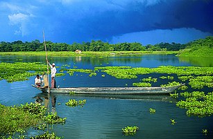
 Loktak lake, Manipur
 -
-
 Nohkalikai Falls, Cherrapunji, Meghalaya


Topography
Highest peaks

Kangchenjunga, the third highest mountain peak in the world rising to an altitude of 8,586 m (28,169 ft), lies in-between the state Sikkim and adjacent country Nepal.
Brahmaputra river basin


Tributaries of the Brahmaputra River in Northeast India:
Climate

Northeast India has a
Under the Köppen climate classification, the region is divided into 3 broad types: A (tropical climates), C (warm temperate mesothermal climates), and D (snow microthermal climates).[53][54] The tropical climates are located in parts of Manipur, Tripura, Mizoram, and the Cachar plains south of 25oN and are classified as tropical wet and dry (Aw).[53] Much of Assam, Nagaland, northern parts of Meghalaya and Manipur and parts of Arunachal Pradesh fall within the warm temperature mesothermal climates (type C) where the mean temperatures in coldest months range from −3 to 18 °C (27 to 64 °F).[54][55] The entire Brahmaputra valley has a humid subtropical climate (Cfa/Cwa) with hot summers.[54][55] At altitudes between 500 and 1,500 m (1,600 and 4,900 ft) located in the eastern hills of Nagaland, Manipur and Arunachal Pradesh, a (Cfb/CWb) climate prevails with warm summers.[54][55] Locations above 1,500 m (4,900 ft) in Meghalaya, parts of Nagaland, and northern Arunachal Pradesh have a (Cfc/Cwc) climate with short and cool summers.[55] Finally, the extreme northern parts of Arunachal Pradesh are classified as humid continental climates with mean winter temperatures below −3 °C (27 °F).[54][56]
- Temperature
Temperatures vary by altitude with the warmest places being in the
In the Brahmaputra and Barak valley river plains, mean winter temperatures vary between 16 and 17 °C (61 and 63 °F) while mean summer temperatures are around 28 °C (82 °F).[57] The highest summer temperatures occur in the West Tripura plain with Agartala, the capital of Tripura having mean maximum summer temperatures ranging between 33 and 35 °C (91 and 95 °F) in April.[60] The highest temperatures in summer occur before the arrival of monsoons and thus eastern areas have the highest temperatures in June and July where the monsoon arrives later than western areas.[60] In the Cachar Plain, located south of the Brahmaputra plain, temperatures are higher than the Brahmaputra plain although the temperature range is smaller owing to higher cloud cover and the monsoons that moderate night temperatures year round.[58][60]
In the mountainous areas of Arunachal Pradesh, the Himalayan ranges in the northern border with India and China experience the lowest temperatures with heavy snow during winter and temperatures that drop below freezing.[58] Areas with altitudes exceeding 2,000 metres (6,562 ft) receive snowfall during winters and have cool summers.[58] Below 2,000 metres (6,562 ft) above sea level, winter temperatures reach up to 15 °C (59 °F) during the day with nights dropping to zero while summers are cool, with a mean maximum of 25 °C (77 °F) and a mean minimum of 15 °C (59 °F).[58] In the hilly areas of Meghalaya, Nagaland, Manipur and Mizoram, winters are cold while summers are cool.[59]
The plains in Manipur has colder winter minimums than what is warranted by its elevation owing to being surrounded by hills on all sides.[61] This is due to temperature inversions during winter nights when cold air descends from the hills into the valleys below and its geographic location which prevents winds that bring hot temperatures and humidity from coming into the Manipur plain.[61] For example, in Imphal, winter daytime temperatures hover around 21 °C (70 °F) but nighttime temperatures drop to 3 °C (37 °F).[61]
- Rainfall
No part of Northeast India receives less than 1,000 mm (39 in) of rainfall a year.[52] Areas in the Brahmputra valley receive 2,000 mm (79 in) of rainfall a year while mountainous areas receive 2,000 to 3,000 mm (79 to 118 in) a year.[52] The southwest monsoon is responsible for bringing 90% of the annual rainfall to the region.[62] April to late October are the months where most of the rainfall in Northeast India occurs with June and July being the rainiest months.[62] In most parts of the region, the average date of onset of the monsoons is 1 June.[63] Southern areas are the first to receive the monsoon (May or June) with the Brahmaputra valley and the mountainous north receiving later (later May or June).[62] In the hilly parts of Mizoram, the closer proximity to the Bay of Bengal causes it to experience early monsoons with June being the wettest season.[62]
High-risk seismic zone
The North Eastern Region of India is a mega-earthquake prone zone caused by active
Wildlife
Flora
.jpg)
The region has been identified by the Indian Council of Agricultural Research as a center of rice germplasm. The National Bureau of Plant Genetic Resources (NBPGR), India, has highlighted the region as being rich in wild relatives of crop plants. It is the center of origin of citrus fruits. Two primitive variety of maize, Sikkim Primitive 1 and 2, have been reported from Sikkim (Dhawan, 1964). Although jhum cultivation, a traditional system of agriculture, is often cited as a reason for the loss of forest cover of the region, this primary agricultural economic activity practised by local tribes supported the cultivation of 35 varieties of crops. The region is rich in medicinal plants and many other rare and endangered taxa. Its high endemism in both higher plants, vertebrates, and avian diversity has qualified it as a biodiversity hotspot.
The following figures highlight the biodiversity significance of the region:[66]
- 51 forest typesare found in the region, broadly classified into six major types – tropical moist deciduous forests, tropical semi-evergreen forests, tropical wet evergreen forests, subtropical forests, temperate forests, and alpine forests.
- Out of the nine important vegetation types of India, six are found in the North Eastern Region.
- These forests harbour 8,000 out of 15,000 species of flowering plants. In floral species richness, the highest diversity is reported from the states of Arunachal Pradesh (5000 species) and Sikkim (4500 species) amongst the North Eastern states.
- According to the Indian Red Data Book, published by the Botanical Survey of India, 10 per cent of the flowering plants in the country are endangered. Of the 1500 endangered floral species, 800 are reported from Northeast India.
- Most of the North Eastern states have more than 60% of their area under forest cover, a minimum suggested coverage for the hill states in the country in order to protect from erosion.
- Northeast India is a part of Indo-Burma hotspot. This hotspot is the second largest in the world, next only to the Mediterranean Basin, with an area 2,206,000 square kilometres (852,000 sq mi) among the 25 identified.[citation needed]
Fauna


The
Northeast India is very rich in faunal diversity. There are as many as 15 species of non-human primates and most important of them are
WWF has identified the following priority ecoregions in North-East India:
- Brahmaputra Valley semi-evergreen forests
- Eastern Himalayan broadleaf forests
- Eastern Himalayan subalpine conifer forests
- Northeast India–Myanmar pine forests
National parks
State symbols
| Arunachal Pradesh | Assam | Manipur | Meghalaya | |||||
|---|---|---|---|---|---|---|---|---|
| Animal | Mithun ( Bos frontalis ) |
Indian rhinoceros (Rhinoceros unicornis) | Sangai (Rucervus eldii eldii) | Clouded leopard (Neofelis nebulosa) | ||||
| Bird | Hornbill ( Buceros bicornis ) |
White-winged duck (Asarcornis scutulata) | Mrs. Hume's pheasant (Syrmaticus humiae) | Hill myna (Gracula religiosa) | ||||
| Flower | Foxtail orchid (Rhynchostylis retusa) | Foxtail orchid (Rhynchostylis retusa) | Siroi lily (Lilium mackliniae) |
Lady's Slipper Orchid (Paphiopedilum insigne) | ||||
| Tree | Hollong (Dipterocarpus macrocarpus) |
Hollong (Dipterocarpus macrocarpus) |
Uningthou (Phoebe hainesiana) | Gamhar (Gmelina arborea) | ||||
| Mizoram | Nagaland | Sikkim | Tripura | |||||
| Animal | Himalayan serow (Capricornis thar) | Mithun ( Bos frontalis ) |
Red panda (Ailurus fulgens) | Phayre's leaf monkey (Trachypithecus phayrei) | ||||
| Bird | Mrs. Hume's pheasant (Syrmaticus humiae) | Blyth's tragopan (Tragopan blythii) | Blood pheasant (Ithaginis cruentus) | Green imperial pigeon (Ducula aenea) | ||||
| Flower | Red Vanda (Renanthera imschootiana) | Tree rhododendron (Rhododendron arboreum) | Noble dendrobium (Dendrobium nobile) | Indian rose chestnut (Mesua ferrea) | ||||
| Tree | Indian rose chestnut (Mesua ferrea) | Alder (Alnus nepalensis) | Rhododendron (Rhododendron niveum) | Agarwood (Aquilaria agallocha) | ||||
Demographics
The total population of Northeast India is 46 million with 68 per cent of that living in Assam alone. Assam also has a higher population density of 397 persons per km2 than the national average of 382 persons per km2. The literacy rates in the states of the Northeastern region, except those in Arunachal Pradesh and Assam, are higher than the national average of 74 per cent. As per 2011 census, Meghalaya recorded the highest population growth of 27.8 per cent among all the states of the region, higher than the national average at 17.64 per cent; while Nagaland recorded the lowest in the entire country with a negative 0.5 per cent.[73]
| State | Population | Males | Females | Sex Ratio | Literacy % | Rural Population | Urban Population | Area (km2) | Density (/km2) |
|---|---|---|---|---|---|---|---|---|---|
| Arunachal Pradesh | 1,383,727 | 713,912 | 669,815 | 938 | 65.38 | 870,087 | 227,881 | 83,743 | 17 |
| Assam | 31,205,576 | 15,939,443 | 15,266,133 | 958 | 72.19 | 23,216,288 | 3,439,240 | 78,438 | 397 |
| Manipur | 2,570,390 | 1,290,171 | 1,280,219 | 992 | 79.21 | 1,590,820 | 575,968 | 22,327 | 122 |
| Meghalaya | 2,966,889 | 1,491,832 | 1,475,057 | 989 | 74.43 | 1,864,711 | 454,111 | 22,429 | 132 |
| Mizoram | 1,097,206 | 555,339 | 541,867 | 976 | 91.33 | 447,567 | 441,006 | 21,081 | 52 |
| Nagaland | 1,978,502 | 1,024,649 | 953,853 | 931 | 79.55 | 1,647,249 | 342,787 | 16,579 | 119 |
| Sikkim | 610,577 | 323,070 | 287,507 | 890 | 81.42 | 480,981 | 59,870 | 7,096 | 86 |
| Tripura | 3,673,917 | 2,087,059 | 2,086,858 | 960 | 91.58 | 2,639,134 | 1,534,783 | 10,486 | 350 |
Largest cities by population
According to
| Rank | City | Type | State | Population | Rank | City | Type | State | Population |
|---|---|---|---|---|---|---|---|---|---|
| 1 | Guwahati | City | Assam | 968,549 | 9 | Jorhat | UA | Assam | 153,889 |
| 2 | Agartala | City | Tripura | 622,613 | 10 | Nagaon | UA | Assam | 147,496 |
| 3 | Imphal | UA | Manipur | 414,288 | 11 | Bongaigaon | UA | Assam | 139,650 |
| 4 | Dimapur | City | Nagaland | 379,769 | 12 | Tinsukia | UA | Assam | 126,389 |
| 5 | Shillong | UA | Meghalaya | 354,325 | 13 | Tezpur | UA | Assam | 102,505 |
| 6 | Aizawl | City | Mizoram | 291,822 | 14 | Kohima | UA | Nagaland | 100,000 |
| 7 | Silchar | UA | Assam | 229,136 | 15 | Gangtok | City | Sikkim | 98,658 |
| 8 | Dibrugarh | UA | Assam | 154,296 | 16 | Itanagar | City | Arunachal Pradesh | 95,650 |
|
UA: Urban Agglomeration[74] | |||||||||
Languages
Northeast India constitutes a single linguistic region within the Indian national context, with about 220 languages in multiple language families (
Among other Indo-Aryan languages,
Official languages
| State | Official Languages[83] |
|---|---|
| Arunachal Pradesh | English |
| Assam | Bengali[84]
|
| Manipur | Meitei |
| Meghalaya | English |
| Mizoram | Mizo, English |
| Nagaland | English[85] |
| Sikkim | Sikkimese, Lepcha, Nepali, English[17] |
| Tripura[86] | Bengali, Kokborok, English |
Etymology of state names
| Name of state | Origin | Literal meaning |
|---|---|---|
| Arunachal Pradesh | Sanskrit | Land of the dawn-lit mountains |
| Assam | native name | Both Assam and Ahom are from asam, acam, a corruption of Shan/Shyam as used for the Ahoms.[87] |
| Manipur | Sanskrit | Land abundant with jewels, adopted in the 18th century |
| Meghalaya | Sanskrit | Abode of the clouds, coined by Shiba P. Chatterjee |
| Mizoram | Mizo language | Land of the Mizo people; Ram means land |
| Nagaland | English | Land of the Naga people |
| Sikkim | Limbu language | New House – Derived from the word "Sukhim", "Su" meaning new and "Khim" meaning house |
| Tripura | Kokborok | Twipra etc. It literally means Land near the Water – Derived from the word "TWIPRA", "Twi" meaning water and "Bupra" meaning near, as Tripura is slightly near the Bay of Bengal .
|
Religions
Religion in Northeast India (2011)
Hinduism is the majority religion in the North Eastern states of Assam, Tripura, Manipur, Sikkim and plurality in Arunachal Pradesh, while Christianity is the majority religion in Meghalaya, Nagaland, Mizoram and plurality in Manipur and Arunachal Pradesh. A significant plurality of the state of Arunachal Pradesh follows the indigenous religion Donyi-Polo. Islam has a significant presence in Assam and about 93% of all North East Muslim population is concentrated in that state alone. A bulk of Christian population in India resides in North East, as about 30% of India's Christian population is concentrated in North Eastern region alone. There is a significant presence of Buddhism in Sikkim, Arunachal Pradesh and Mizoram.[88]
| State | Hinduism | Islam | Christianity | Buddhism | Jainism | Sikhism | Other Religions | Religion Not Stated |
|---|---|---|---|---|---|---|---|---|
| Arunachal Pradesh | 401,876 | 27,045 | 418,732 | 162,815 | 771 | 3,287 | 362,553 | 6,648 |
| Assam | 19,180,759 | 10,679,345 | 1,165,867 | 54,993 | 25,949 | 20,672 | 27,118 | 50,873 |
| Manipur | 1,181,876 | 239,836 | 1,179,043 | 7,084 | 1,692 | 1,527 | 233,767 | 10,969 |
| Meghalaya | 342,078 | 130,399 | 2,213,027 | 9,864 | 627 | 3,045 | 258,271 | 9,578 |
| Mizoram | 30,136 | 14,832 | 956,331 | 93,411 | 376 | 286 | 808 | 1,026 |
| Nagaland | 173,054 | 48,963 | 1,739,651 | 6,759 | 2,655 | 1,890 | 3,214 | 2,316 |
| Sikkim | 352,662 | 9,867 | 60,522 | 167,216 | 314 | 1,868 | 16,300 | 1,828 |
| Tripura | 3,063,903 | 316,042 | 159,882 | 125,385 | 860 | 1,070 | 1,514 | 5,261 |
| Total | 24,726,344 | 11,466,329 | 7,893,055 | 627,527 | 33,244 | 33,645 | 903,545 | 88,499 |
Ethnic groups
Northeast India has over 220 ethnic groups and an equal number of dialects in which
Majority communities
These ethnic groups form significant majorities in the states/regions of Northeast India:
- Assamese people - (48.38%), largest ethnicity in Assam
- Tani People - (40.32%), largest ethnicity in Arunachal Pradesh
- Bodolandregion of Assam
- Bengali people - (63.48% and 80.84%), largest ethnicity in Tripura state and Barak Valleyregion of Assam
- Meitei people - (53.3%), largest ethnicity in Manipur
- Tripuri people - largest ethnicity in Tripura Tribal Areas Autonomous District Council of Tripura
- Mizo people - (73.14%), largest ethnicity in Mizoram
- Khasi people - (46.24%), largest ethnicity in Meghalaya
- Naga people - (88.24%), largest ethnicity in Nagaland
- Nepali people - (62.6%), largest ethnicity in Sikkim
- Sikkimese people - native ethnicity of Sikkim
Minority communities
These ethnic groups form minorities in the states of Northeast India:
- Bhojpuri
- Bishnupriya
- Biate
- Bodo
- Chakma
- Deori
- Dimasa
- Garo
- Hajong
- Hmar
- Karbi
- Kami (caste)
- Khampti
- Koch Rajbongshi
- Kom
- Lepcha
- Limbu
- Lotha Naga
- Miji
- Miyas
- Mara
- Mishmi
- Nyishi
- Nepali
- Paite
- Pnar
- Purvottar maithili
- Rabha
- Ranglong(Langrong)
- Rai
- Singpho
- Sylheti
- Tamang
- Tiwa
- Tripuri
- Kuki people (Kuki: Thadou, Baite, Mate, Khongsai, Haokip, Doungel, Hangmi, Touthang, Kipgen, Hangmi, Neisel, Chongloi, Hangsing, Guite, etc.)
-
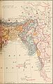 British India map of Northeast India by ethnicity and Language, 1891
 -
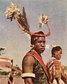 A Naga warrior in 1960
 -

-
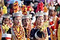 Shad suk Mynsiem, a Khasi festival
 -
 Traditional Hajong Clothing
 -
 Aka tribe, Arunachal Pradesh
 -
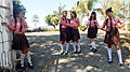 Mizo school girls
 -

-
 Princess of Sikkim in traditional royal dress
 -
 Tripuri woman in traditional attire
 -
 Asamiya youth in Bihu attire.


Ethnic groups by population
| Rank | Ethnic Group | Population | States with significant population | ||||||||||||||||||||||||||||||||||||||||||||||||||||||||||||||||
|---|---|---|---|---|---|---|---|---|---|---|---|---|---|---|---|---|---|---|---|---|---|---|---|---|---|---|---|---|---|---|---|---|---|---|---|---|---|---|---|---|---|---|---|---|---|---|---|---|---|---|---|---|---|---|---|---|---|---|---|---|---|---|---|---|---|---|---|
| 1 | Assamese | 15,300,000 | Assam | ||||||||||||||||||||||||||||||||||||||||||||||||||||||||||||||||
| 2 | Bengali | 15,000,000 | Assam, Tripura | ||||||||||||||||||||||||||||||||||||||||||||||||||||||||||||||||
| 3 | Koch Rajbongshi
|
7,000,000 | Assam | ||||||||||||||||||||||||||||||||||||||||||||||||||||||||||||||||
| 4 | Naga | 2,500,000 | Nagaland, Manipur | ||||||||||||||||||||||||||||||||||||||||||||||||||||||||||||||||
| 5 | Meitei | 2,370,000 | Manipur, Assam | ||||||||||||||||||||||||||||||||||||||||||||||||||||||||||||||||
| 6 | Mizo
a. Hmar b. Lai c. Kuki d. Lusei e. Zomi f. Ralte g. Mara |
2,217,202[92]
|
Mizoram, Manipur | ||||||||||||||||||||||||||||||||||||||||||||||||||||||||||||||||
| 7 | Nepali
|
1,700,000 | Sikkim | ||||||||||||||||||||||||||||||||||||||||||||||||||||||||||||||||
| 8 | Khasi | 1,500,000 | Meghalaya | ||||||||||||||||||||||||||||||||||||||||||||||||||||||||||||||||
| 9 | Bodo | 1,400,000 | Assam (Bodoland) | ||||||||||||||||||||||||||||||||||||||||||||||||||||||||||||||||
| 10 | Garo | 1,100,000 | Meghalaya | ||||||||||||||||||||||||||||||||||||||||||||||||||||||||||||||||
| 11 | Tripuri | 1,000,000 | Tripura | ||||||||||||||||||||||||||||||||||||||||||||||||||||||||||||||||
| 12 | Mising | 687,000 | Assam | ||||||||||||||||||||||||||||||||||||||||||||||||||||||||||||||||
| 13 | Karbi | 528,000 | Assam (Karbi Anglong) | ||||||||||||||||||||||||||||||||||||||||||||||||||||||||||||||||
| 14 | Pnar | 395,000 | Meghalaya | ||||||||||||||||||||||||||||||||||||||||||||||||||||||||||||||||
| 15 | Tiwa | 371,000 | Assam | ||||||||||||||||||||||||||||||||||||||||||||||||||||||||||||||||
| 16 | Rabha | 330,000 | Assam | ||||||||||||||||||||||||||||||||||||||||||||||||||||||||||||||||
| 17 | Dimasa | 262,000 | Assam (Dima Hasao) | ||||||||||||||||||||||||||||||||||||||||||||||||||||||||||||||||
| 18 | Nyishi | 250,000 | Arunachal Pradesh | ||||||||||||||||||||||||||||||||||||||||||||||||||||||||||||||||
| 19 | Chakma | 230,000 | Mizoram (Chakma Autonomous District Council), Tripura | ||||||||||||||||||||||||||||||||||||||||||||||||||||||||||||||||
| 20 | Others |
Culture
Cuisines
| State | Staple diet | Popular dishes |
|---|---|---|
Arunachal Pradesh |
Rice, fish, meat, leaf vegetables |
rice beer )
|
| Assam | Rice, fish, meat, leaf vegetable | Apong , etc.)
|
Manipur |
Rice, fish, local vegetables | u-morok, singju , ngari (fermented fish), kangshoi
|
Meghalaya |
Rice, spiced meat, fish | Khasi dishes – Thungtap, Dohjem, Thungrumbai, Jadoh, ki kpu, Garo dishes – kappa, brenga, so•tepa, wa•tepa, pura, minil, na•kam (dried fish), bamboo shoot |
| Mizoram | Rice, fish, meat | Bai, bekang (fermented soya beans), sa-um (fermented pork), sawhchiar |
| Nagaland | Rice, meat, stewed or steamed vegetables | fermented bamboo shoot, smoked pork and beef, bhut jolokia
|
| Sikkim | Rice, meat, dairy products | |
| Tripura | Rice, meat, vegetables | Maidul (rice ball), Awang bangwi, Awang sokrang, Chakhūi, Gudok, Mosodeng, Awandru, Mūkhūi, Hangjak, Yikjak, Wahan mosodeng, Muiya (bamboo shoot), Berma Bwtwi (fermented fish) |
-

-
 Bangwi - Tripuri food of Tripura
 -
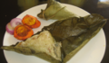
 Paknam (Manipur)
 -
 Basic Tripuri lunch thali
 -
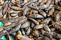 Smoked freshwater fish (Manipur)
 -
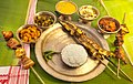
 North Sikkimmeal
 -
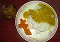
 Assamese thali
 -
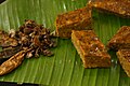
 Red rice with pork (Arunachal Pradesh)


Arts
The
All states in Northeast India share the handicrafts of bamboo and cane, wood carving, making traditional weapons and musical instruments, pottery and handloom weaving. Traditional tribal attires are made of thick fabrics primarily with cotton.[97] Assam silk is a famous industry in the region.
| State | Traditional Performing Arts
|
Traditional Visual Arts
|
Traditional Crafts
|
|---|---|---|---|
| Arunachal Pradesh | Wancho dances, Idu Mishmi dance, Digaru Mishmi Buiya dance, Khampti dance, Ponung dance, Sadinuktso[98] | Cane and bamboo, cotton and wool weaving, wood carving, blacksmithy (hand tools, weapons, ornaments, dishes, sacred bells and smoking pipes)[98][99] | |
| Assam | Sattriya, Bagurumba, Bihu dance, Bhaona (For more see Music of Assam) | Fine Arts of Assam ) |
Cane and bamboo, bell metal and brass, silk, toys, and mask making, pottery and terracotta, jewellery, musical instruments making, boat making, paints. |
| Manipur | Manipuri dance (Ras Lila), Kartal Cholom, Manjira Cholom, Khubak Eshei, Pung Cholom, Lai-Haraoba | Cotton textile, bamboo crafts (hats, baskets), pottery[99][97] | |
| Meghalaya | Nongkrem, Shad suk, Behdienkhlam, Wangala, Lahoo dance[100][99] (For more see Music of Meghalaya) | Making hand tools and weapons, musical instruments (drums), cane and bamboo work, weaving traditional attires, jewellery making (gold, coral, glass), wall engravings, wood carving[99][101] | |
| Mizoram | Music of Mizoram ), Bizhu Dance |
Traditional hand tools, weapons and textile work, bamboo and cane handicrafts[103][99] | |
| Nagaland | Zeliang dance, war dance, Nruirolians (cock dance) (For more see Music of Nagaland) | Cane and bamboo crafts, traditional hand tools, weapons and textile work, wood carving, pottery, ornaments for traditional attire, musical instruments (drum and trumpet)[99] | |
| Sikkim | Chu Faat dance, Lu Khangthamo, Gha To Kito, Rechungma, Maruni, ) | Thangka (showcasing Buddhist teachings on cotton canvas using vegetable dyes)[105] | Handmade paper, carpet making, woollen textile, wood carving[105]
|
| Tripura | Owa dance |
Rock curbings of different gods and goddesses | Cane and bamboo, Traditional cotton textiles, weaving and handloom, moluwa /sitalpati(mat making), wood carving,[99] string and wind musical instruments |
-

-
 Assamese youths performing Bihu dance.
 -
 Nyokum festival ofNyishi tribe (Arunachal Pradesh)
 -
-
 Bodo tribe (Assam)
 -
-
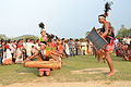
 Dance of Angami tribe (Nagaland)
 -


Music
Northeast is a hub of different genres of music. Each community has its own rich heritage of folk music. Talented musicians and singers are plentifully found in this part of the country. The Assamese singer-composer
Literature
Many of the Northeast Indian indigenous communities have an ancient heritage of
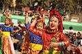
Festivals
Indigenous festivals in the northeast include the Ojiale festival of the
Administration and political disputes
International borders management
- McMahon Line and China–India border crossings patrolled by Indo-Tibetan Border Police and Special Frontier Force with China along Sikkim and Arunachal Pradesh
- India-Bangladesh border and crossings patrolled by Border Security Force along Assam, Meghalaya, Tripura and Mizoram
- crossings patrolled by Assam Rifles and Indian Armyalong Arunachal Pradesh, Nagaland, Manipur and Mizoram
- India-Bhutan borders patrolled by Sashastra Seema Bal along Sikkim, Assam and Arunachal Pradesh
- India-Nepal border patrolled by Sashastra Seema Bal along Sikkim
Pan-states development authorities
- Ministry for Development of North Eastern Region(DoNER)
- North Eastern Council
States and sub-divisions
| State | Code | Capital | Districts | Sub-division Type | Number of Subdivisions |
|---|---|---|---|---|---|
| Arunachal Pradesh | IN-AR | Itanagar | 20 | Circle | 149 |
| Assam | IN-AS | Dispur | 35 | Sub-division | 78 |
| Manipur | IN-MN | Imphal | 16 | Sub-division | 38 |
| Meghalaya | IN-ML | Shillong | 12 | Community Development Block |
39 |
| Mizoram | IN-MZ | Aizawl | 11 | Community Development Block | 22 |
| Nagaland | IN-NL | Kohima | 16 | Circle | 33 |
| Sikkim | IN-SK | Gangtok | 6 | Sub-division | 9 |
| Tripura | IN-TR | Agartala | 8 | Sub-division | 23 |

| State | Autonomous Division | Establishment |
|---|---|---|
| Assam | Bodoland Territorial Area Districts |
February 2003 |
| Dima Hasao district | February 1970 | |
| Karbi Anglong district | February 1970 | |
| Mising Autonomous Council | 1995 | |
| Rabha Hasong Autonomous Council | 1995 | |
| Manipur[114][115] | Churachandpur Autonomous District Council | 1971 |
| Chandel Autonomous District Council | 1971 | |
| Senapati Autonomous District Council | 1971 | |
| Sadar Hills Autonomous District Council | 1971 | |
| Tamenglong Autonomous District Council | 1971 | |
| Ukhrul Autonomous District Council | 1971 | |
| Meghalaya | Garo Hills Autonomous District Council | |
| Jaintia Hills Autonomous District Council | July 2012 | |
| Khasi Hills Autonomous District Council | ||
| Mizoram | Chakma Autonomous District Council | April 1972 |
| Lai Autonomous District Council | April 1972 | |
| Mara Autonomous District Council | May 1971 | |
| Tripura | Tripura Tribal Areas Autonomous District Council | January 1982 |
Government
The northeastern states, having 3.8% of India's total population, are allotted 25 out of a total of 543 seats in the Lok Sabha. This is 4.6% of the total number of seats.[citation needed]
| State | Chief Minister[116]
|
Governor[117]
|
High Court
|
Chief Justice |
|---|---|---|---|---|
| Arunachal Pradesh | Pema Khandu | Kaivalya Trivikram Parnaik | Guwahati High Court (Itanagar Bench) |
Sandeep Mehta, Chief Justice |
| Assam | Himanta Biswa Sarma | Gulab Chand Kataria | Guwahati High Court |
Sandeep Mehta, Chief Justice |
| Manipur | Nongthombam Biren Singh |
Anusuiya Uikye | Manipur High Court | Justice M. V. Muralidharan |
| Meghalaya | Conrad Sangma | Phagu Chauhan | Meghalaya High Court | Justice Sanjib Banerjee |
| Mizoram | Lalduhoma | Kambhampati Hari Babu | Guwahati High Court (Aizawl Bench) |
Sandeep Mehta, Chief Justice |
| Nagaland | Neiphiu Rio | La Ganesan | Guwahati High Court (Kohima Bench) |
Sandeep Mehta, Chief Justice |
| Sikkim | Prem Singh Tamang | Ganga Prasad | Sikkim High Court | Justice Satish K. Agnihotri |
| Tripura | Manik Saha | Indrasena Reddy |
Tripura High Court | Justice T. A. Gaur |
20th century separatist unrest
In 1947 Indian independence and partition resulted in the North East becoming a landlocked region. This exacerbated the isolation that has been recognised, but not studied. East Pakistan controlled access to the Indian Ocean.[118] The mountainous terrain has hampered the construction of road and railways connections in the region.[citation needed]
Several militant groups have formed an alliance to fight against the governments of India, Bhutan, and Myanmar, and now use the term "Western Southeast Asia" (WESEA) to refer to the region.
Economy
The
List of NE states by NSDP 2023-24
| Rank | State | NSDP in
Indian Rupees ₹ |
NSDP in
US Dollars $ |
NSDP Per Capita
in ₹ |
|---|---|---|---|---|
| 1 | Assam | ₹ 5,67,000 crore | $69 Billions | ₹ 1,58,734 |
| 2 | Tripura | ₹ 89,000 crore | $8 Billions | ₹ 2,14,458 |
| 3 | Sikkim | ₹ 47,331 crore | $3.88 Billions | ₹ 6,85,957 |
| 4 | Meghalaya | ₹ 46,600 crore | $5 Billions | ₹ 1,39,104 |
| 5 | Manipur | ₹ 45,145 crore | $5.52 Billions | ₹ 1,39,768 |
| 6 | Arunachal Pradesh | ₹ 37,870 crore | $4.6 Billions | ₹ 2,07,506 |
| 7 | Nagaland | ₹ 37,300 crore | $3.79 Billions | ₹ 90,666 |
| 8 | Mizoram | ₹ 35,904 crore | $4.3 Billion | ₹ 2,89,548 |
Industries
Agriculture
The economy is agrarian. Little land is available for settled agriculture. Along with settled agriculture, jhum (slash-and-burn) cultivation is still practised by a few indigenous groups of people. The inaccessible terrain and internal disturbances have made rapid industrialisation difficult in the region.[citation needed]


.jpg)

Tourism
Living Root Bridges


